I don't see a spin... but a lot of convection lingering this morning in the northern Gulf:
http://www.ssd.noaa.gov/goes/east/gmex/flash-vis.html
Models show low pressure forming in the NE Gulf of Mexico
Moderator: S2k Moderators
Forum rules

The posts in this forum are NOT official forecasts and should not be used as such. They are just the opinion of the poster and may or may not be backed by sound meteorological data. They are NOT endorsed by any professional institution or STORM2K. For official information, please refer to products from the National Hurricane Center and National Weather Service.
-
wx247

- S2K Supporter

- Posts: 14279
- Age: 42
- Joined: Wed Feb 05, 2003 10:35 pm
- Location: Monett, Missouri
- Contact:
0 likes
Personal Forecast Disclaimer:
The posts in this forum are NOT official forecast and should not be used as such. They are just the opinion of the poster and may or may not be backed by sound meteorological data. They are NOT endorsed by any professional institution or storm2k.org. For official information, please refer to the NHC and NWS products.
The posts in this forum are NOT official forecast and should not be used as such. They are just the opinion of the poster and may or may not be backed by sound meteorological data. They are NOT endorsed by any professional institution or storm2k.org. For official information, please refer to the NHC and NWS products.


Look at these rainfall rates! Upwards of 4 inches per hour:
http://radar.weather.gov/radar.php?rid= ... 11&loop=no
http://radar.weather.gov/radar.php?rid= ... 11&loop=no
0 likes

Re: GFDL shows low forming in the NE Gulf of Mexico.
AREA FORECAST DISCUSSION
NATIONAL WEATHER SERVICE TALLAHASSEE FL
1048 AM EDT THU JUL 1 2010
.UPDATE...VERY MOIST TROPICAL AIR MASS IN PLACE ACROSS THE REGION
THIS MORNING. 12Z SOUNDING INDICATED 2.44 INCHES OF PWAT WITH A
MODIFIED CAPE AROUND 2500 J/KG. SFC ANALYSIS REVEALS AN E-W
STATIONARY FRONT ACROSS CENTRAL GEORGIA AND ALABAMA SEPARATING MID
70S DEWPOINTS TO THE SOUTH FROM MID 60S DEWPOINTS TO THE NORTH. IN
ADDITION...SFC OBS INDICATES A WEAK INVERTED TROUGH ORIGINATING IN
APALACHEE BAY STRETCHING NORTH INTO SOUTH GEORGIA NEAR VALDOSTA.REGIONAL RADAR ALSO INDICATES SOME LOW TO MID-LEVEL CYCLONIC
TURNING WITH THIS FEATURE. ELSEWHERE ON THE RADAR...WIDESPREAD
SHOWERS AND THUNDERSTORMS CONTINUE OVER THE COASTAL WATERS WITH
ACTIVITY BEGINNING TO SLOWLY SPREAD INLAND.
0 likes
If this GFS vorticity map pans out, we should see our low pressure area drop SW from southern GA and into Apalachee Bay by tomorrow...then slowly move west toward SE LA...then stall over LA/MS/AL for several days...could be a major rainmaker!
http://moe.met.fsu.edu/cgi-bin/gfstc2.c ... =Animation
http://moe.met.fsu.edu/cgi-bin/gfstc2.c ... =Animation
0 likes
Mobile NWS from this morning...very interesting:
SHORT TERM (FRIDAY THROUGH SATURDAY NIGHT)...LOOKS LIKE MODEL
OUTPUT CALCULATIONS ARE PRETTY CONGRUENT ON THE 00Z CYCLE FOR TAU 00
TO 36. THEN FROM TAU 48 TO 72, SCATTER BEGINS TO DEVELOP ON THE
PROBLEM OF THE BAROTROPIC WAVE OFF THE COAST OF THE FLORIDA
PANHANDLE. OUR SKEPTICISM REMAINS FOR 6 TO 8 INCHES OF RAIN, BUT ONE
CAN ALMOST UNDERSTAND WHY THE MODEL SUITE IS PICKING THIS UP. IT
APPEARS THEY`RE ALL GRABBING AN EVENT ASSOCIATED WITH A SATELLITE
FEATURE THAT CAN BE SEEN ON THE IR AND WATER VAPOR, THAT PROPAGATES
SOUTH AGAINST THE MEAN LAYER FLOW. WE BELIEVE THAT FEATURE IS BEING
GROWN IN THE GRIDS AND IS WINDING UP IN SEVERAL DIFFERENT POSITIONS,
OR STATES OF EXISTENCE, DEPENDING ON WHICH MODEL WE LOOK AT. AS OF
FRIDAY MORNING, FOR TAU 48, THE ECMWF AND GFS ARE THE MAJOR
PROPONENTS OF THIS FEATURE, AND THE OTHERS, THE GEM, UKMET, AND NAM,
TEND TO DAMPEN IT. THROUGH SATURDAY EVENING THE NAYSAYERS GET ON THE
BANDWAGON AND DEVELOP THE THING ANYWHERE FROM SOUTHWEST PASS TO OFF
PANAMA CITY. THEN, WITH ONLY THE AVAILABILITY OF THE GEM, ECMWF, AND
GFS, THE ECMWF LOSES ALL TRACK OF IT AND THE OTHER TWO KEEP IT
HANGING AROUND ALONG THE BEACH. AS FOR THIS FRONT, WHICH LOOKS LIKE
IT WANTS TO STAGE A PAS-DE-DEUX WITH THAT BAROTROPIC FEATURE, IT IS
BRINGING IN DRY AIR WHICH SHOWS PROPENSITY TO ARRIVE ALONG THE COAST
BY FRIDAY. POPS WERE SCALED BACK INTO FRIDAY, WITH A STEEP GRADIENT
ALONG THE COAST INDICATING RAIN OFFSHORE AND DRY INLAND. IT IS HARD
FOR FRONTS TO GET THIS FAR SOUTH THIS TIME OF YEAR, BECAUSE THE
TEMPERATURE GRADIENTS AND ABSENCE OF A STRONG JET STREAM, INDIRECT
JET CIRCULATIONS, AND AGEOSTROPHIC FORCING, ALL TENDING TO BE
MINIMAL, AND HENCE, WE HAVE FRONTOLYSIS.
.LONG TERM (SUNDAY THROUGH THURSDAY)...THE GFS KEEPS HANGING TIGHT
ON THE BAROTROPIC FEATURE THROUGH TAU 240 WANDERING AIMLESSLY AROUND
THE I-10 CORRIDOR BETWEEN MOBILE AND BATON ROUGE. MEANWHILE THE
WAVENUMBER 5 PICTURE INDICATES THE OVERALL DOMINANCE OF AN RIDGE AT
500 MB, SO THE EFFECT OF THIS AS A RAINMAKER MAY NOT BE TOO FAR OFF
THE MARK. BAS IT WAS SAID BEFORE, 6 TO 8 INCHES AND MORE EVERY 6
HOURS LOOKED WRONG, AND THIS CYCLE, THE WHOLE GROUP BACKED OFF THOSE
FIGURES BY ALMOST A FACTOR OF TWO. WE USED THE EVEN SMALLER NUMBERS
OFFERED IN HPC GUIDANCE.
A FEW OF THE MODELS WANT TO DEVELOP A WEAK LOW PRESSURE SYSTEM OVER
THE NE GULF LATER IN THE WEEK AND TRACK IT WESTWARD ACROSS THE
NORTHERN GULF. WITH AN ELONGATED EASTWARD BAND OF COLD CLOUD TOPS
OVER THE NORTHERN GULF...THERE COULD BE SOME SUPPORT FOR THIS.
HOWEVER...CONTINUITY AMONGST THE GLOBAL MODELS ARE POOR AT THIS
TIME...SO WILL MAINTAIN OFFICIAL FORECAST CONTINUITY ON AN EAST TO
SOUTHEAST FLOW 10-15KTS INTO THE WEEKEND. WE`LL CONTINUE TO WATCH THE
CONVECTION OVER THE NE GULF NEXT COUPLE DAYS AND SEE WHAT HAPPENS.
http://forecast.weather.gov/product.php ... glossary=1
0 likes
-
mattpetre
- Category 2

- Posts: 510
- Age: 54
- Joined: Mon Sep 19, 2005 3:20 pm
- Location: Missouri City,TX & Galleria
- Contact:
Re: GFDL shows low forming in the NE Gulf of Mexico.
I was looking at the satellite presentation of Alex just a few minutes ago and thought it was curious how much of the frontal / Alex outer bands were building and lingering in the Northern Gulf. So I searched for this thread and found that it had existed for a few days. I'm thinking we may get a major mess-maker out of this thing and in the worst of all possible locations, well maybe it isn't so terrible for the spill to get spread out a little, I'm not sure... Hate the idea of oily rain getting all over everything, but at the same time perhaps it's this sort of dilution that will make it all somewhat ecologically tolerable. Crap, what am I thinking, this stinks. Anyway, I do think there is a good chance something will spin up in the N. Gulf 4th of July weekend into next week.
0 likes
Re: GFDL shows low forming in the NE Gulf of Mexico.
Could be something starting to get going in Appalachee Bay.
http://radar.weather.gov/radar.php?product=N0Z&rid=tlh&loop=yes
http://radar.weather.gov/radar.php?product=N0Z&rid=tlh&loop=yes
0 likes
-
tolakram
- Admin

- Posts: 20189
- Age: 62
- Joined: Sun Aug 27, 2006 8:23 pm
- Location: Florence, KY (name is Mark)
Re: GFDL shows low forming in the NE Gulf of Mexico.
Interesting. Some inflow, and unfortunately a strong flow that will help push oil on shore.
http://wwwghcc.msfc.nasa.gov/cgi-bin/ge ... mframes=10
Air pressure is still rising post Alex:
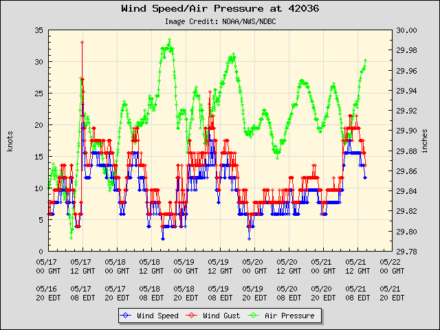
http://www.ndbc.noaa.gov/station_page.php?station=42036
There are plenty of buoys in this area to watch.
http://wwwghcc.msfc.nasa.gov/cgi-bin/ge ... mframes=10
Air pressure is still rising post Alex:
http://www.ndbc.noaa.gov/station_page.php?station=42036
There are plenty of buoys in this area to watch.
0 likes
M a r k
- - - - -
Join us in chat: Storm2K Chatroom Invite. Android and IOS apps also available.
The posts in this forum are NOT official forecasts and should not be used as such. Posts are NOT endorsed by any professional institution or STORM2K.org. For official information and forecasts, please refer to NHC and NWS products.

Re: GFDL shows low forming in the NE Gulf of Mexico.
12Z GFS remains persistent with low development.

0 likes
Re: GFDL shows low forming in the NE Gulf of Mexico.
Shear looks marginal for development. Probably why the models keep it weak.

0 likes
-
Stormcenter
- S2K Supporter
- Posts: 6689
- Joined: Wed Sep 03, 2003 11:27 am
- Location: Houston, TX
Well you be judge. Maybe something inland spinning around the panhandle.
http://www.rap.ucar.edu/weather/satelli ... uration=12
http://www.rap.ucar.edu/weather/satelli ... uration=12
0 likes
-
Weatherfreak000
Re: GFDL shows low forming in the NE Gulf of Mexico.
GFS, GFDL and past runs of HWRF have been seeing this, as well as Bob Breck's VIPIR model.
Strong consistency for a system that's less than three days out.
Strong consistency for a system that's less than three days out.
0 likes
-
Frank P
- S2K Supporter
- Posts: 2779
- Joined: Fri Aug 29, 2003 10:52 am
- Location: Biloxi Beach, Ms
- Contact:
Re: GFDL shows low forming in the NE Gulf of Mexico.
I see some kind of spin, perhaps in the mid levels at 30.2 and 83.6 slightly inland and drifting towards the SSW.. but that's a stretch.. put the loop in a fast mode and you might see it.. fwiw..
Last edited by Frank P on Thu Jul 01, 2010 11:43 am, edited 1 time in total.
0 likes
-
Stormcenter
- S2K Supporter
- Posts: 6689
- Joined: Wed Sep 03, 2003 11:27 am
- Location: Houston, TX
Re: GFDL shows low forming in the NE Gulf of Mexico.
That's what I'm seeing too. I'm starting to think that "maybe" the models
may be on to something here.
may be on to something here.
Frank P wrote:I sorts see some kind of spin, perhaps in the mid levels at 30.2 and 83.6 slightly inland and drifting towards the SSW.. but that's a stretch.. put the loop in a fast mode and you might see it.. fwiw..
0 likes
-
Frank P
- S2K Supporter
- Posts: 2779
- Joined: Fri Aug 29, 2003 10:52 am
- Location: Biloxi Beach, Ms
- Contact:
Re: GFDL shows low forming in the NE Gulf of Mexico.
Nothing like watching some home brew in the back yard on a Holiday Weekend.. if it develops at all..
0 likes
Re: GFDL shows low forming in the NE Gulf of Mexico.
Weatherfreak000 wrote:GFS, GFDL and past runs of HWRF have been seeing this, as well as Bob Breck's VIPIR model.
Strong consistency for a system that's less than three days out.
Add the CMC, Euro, and NAM - although a weaker version in ECM and NAM.
0 likes
Re:
Stormcenter wrote:Well you be judge. Maybe something inland spinning around the panhandle.
http://www.rap.ucar.edu/weather/satelli ... uration=12
SC, I can see the rotation just north of Appalachee Bay over the FL panhandle. This is exactly where GFS drops the vorticity down from.
0 likes
Re: Models show low pressure forming in the NE Gulf of Mexico
If GFS is to be believed, this low will be meandering over the northern gulf coast region for 7 days!
http://www.nco.ncep.noaa.gov/pmb/nwprod/analysis/carib/gfs/12/index_pcp_s_loop.shtml
http://www.nco.ncep.noaa.gov/pmb/nwprod/analysis/carib/gfs/12/index_pcp_s_loop.shtml
0 likes
Who is online
Users browsing this forum: MarioProtVI and 95 guests