Wave in Caribbean

This is the general tropical discussion area. Anyone can take their shot at predicting a storms path.

Moderator: S2k Moderators

Forum rules

The posts in this forum are NOT official forecasts and should not be used as such. They are just the opinion of the poster and may or may not be backed by sound meteorological data. They are NOT endorsed by any professional institution or STORM2K. For official information, please refer to products from the National Hurricane Center and National Weather Service.

Help Support Storm2K
Message
Author
User avatar
KWT
Category 5
Category 5
Posts: 31415
Joined: Tue Aug 17, 2004 11:02 am
Location: UK!!!

Re: Wave in Eastern Atlantic (A preview of things to come?)

#61 Postby KWT » Fri Jun 04, 2010 10:04 am

cycloneye wrote:Guess what peeps,the wave I have been following is still alive and well with a weak turning.By the way,its forecast to bring very bad weather to the NE Caribbean a week from today as the AFD of San Juan says.


Ah that probably is a wave that the ECM is showing some small intrest in, coming intothe Caribbean about 6-7 days time then getting into the S.Gulf by 240hrs.
0 likes   
Personal Forecast Disclaimer:
The posts in this forum are NOT official forecast and should not be used as such. They are just the opinion of the poster and may or may not be backed by sound meteorological data. They are NOT endorsed by any professional institution or storm2k.org. For official information, please refer to the NHC and NWS products

User avatar
Pedro Fernández
Tropical Storm
Tropical Storm
Posts: 233
Age: 47
Joined: Mon Dec 31, 2007 7:24 am
Location: Costa Tropical (Granada, Spain).
Contact:

#62 Postby Pedro Fernández » Fri Jun 04, 2010 11:43 am

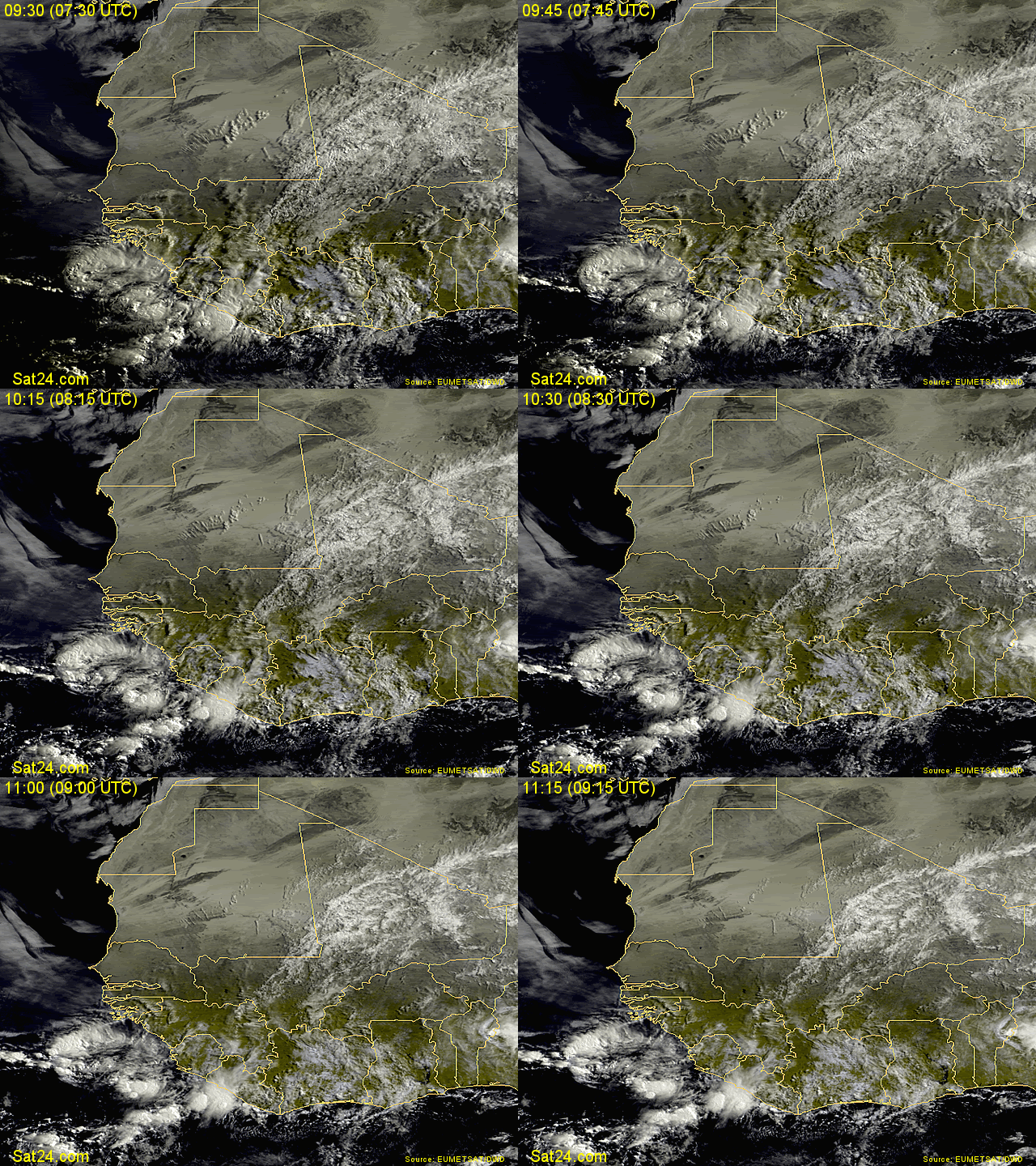
A new huge tropical wave is located inland África in the 12 UTC infrarred image. Surely it will reach the Atlantic Ocean in the next hours. Amazing. 8-)
0 likes   

User avatar
cycloneye
Admin
Admin
Posts: 145568
Age: 68
Joined: Thu Oct 10, 2002 10:54 am
Location: San Juan, Puerto Rico

Re: Wave in Eastern Atlantic (A preview of things to come?)

#63 Postby cycloneye » Fri Jun 04, 2010 2:07 pm

Here is an excerpt of the AFD in San Juan that talks about this particular wave that is around 25W as I am posting this.

http://forecast.weather.gov/product.php ... glossary=1

THE GFS MODEL GUIDANCE SUGGESTS THAT A WEAK TROPICAL WAVE WILL MOVE
MAINLY SOUTH OF THE REGION BY TUESDAY. THIS FEATURE WILL BRING A
SLIGHT INCREASE IN MOISTURE...WITH SHOWERS AND THUNDERSTORMS ACROSS
PARTS OF THE REGION BY MID WEEK. A WELL DEFINED TROPICAL WAVE WILL
FOLLOW BY FRIDAY NEXT WEEK...BRINGING WITH IT A GENERAL INCREASE IN
CLOUDINESS...SHOWERS AND THUNDERSTORMS
.
0 likes   
Visit the Caribbean-Central America Weather Thread where you can find at first post web cams,radars
and observations from Caribbean basin members Click Here

Parungus
Tropical Wave
Tropical Wave
Posts: 4
Joined: Mon Mar 15, 2010 4:49 pm

Re:

#64 Postby Parungus » Sat Jun 05, 2010 7:04 am

Pedro Fernández wrote:A new huge tropical wave is located inland África in the 12 UTC infrarred image. Surely it will reach the Atlantic Ocean in the next hours. Amazing. 8-)


Yesterday:

Image


Today:

Image


Saludos, Pedro. :wink:
0 likes   

User avatar
Gustywind
Category 5
Category 5
Posts: 12334
Joined: Mon Sep 03, 2007 7:29 am
Location: Baie-Mahault, GUADELOUPE

#65 Postby Gustywind » Sat Jun 05, 2010 7:46 am

Image
Image
0 likes   

User avatar
cycloneye
Admin
Admin
Posts: 145568
Age: 68
Joined: Thu Oct 10, 2002 10:54 am
Location: San Juan, Puerto Rico

Re: Wave in Eastern Atlantic (A preview of things to come?)

#66 Postby cycloneye » Sun Jun 06, 2010 5:39 am

Good news about the wave that I have been following is that we can see it in the Central Atlantic images,so no waiting for 3-6 hours intervals of new pics. Speaking of the wave,it has increased convection and the small circulation is still with it.This high amplitude wave is forecast to affect the Eastern Caribbean by next friday.

Image
0 likes   
Visit the Caribbean-Central America Weather Thread where you can find at first post web cams,radars
and observations from Caribbean basin members Click Here

User avatar
KWT
Category 5
Category 5
Posts: 31415
Joined: Tue Aug 17, 2004 11:02 am
Location: UK!!!

#67 Postby KWT » Sun Jun 06, 2010 7:43 am

Yeah the ITCZ is looking decent as you'd expect as we head into the hurricane season.
0 likes   
Personal Forecast Disclaimer:
The posts in this forum are NOT official forecast and should not be used as such. They are just the opinion of the poster and may or may not be backed by sound meteorological data. They are NOT endorsed by any professional institution or storm2k.org. For official information, please refer to the NHC and NWS products

User avatar
Gustywind
Category 5
Category 5
Posts: 12334
Joined: Mon Sep 03, 2007 7:29 am
Location: Baie-Mahault, GUADELOUPE

#68 Postby Gustywind » Sun Jun 06, 2010 8:02 am

Image
0 likes   

User avatar
cycloneye
Admin
Admin
Posts: 145568
Age: 68
Joined: Thu Oct 10, 2002 10:54 am
Location: San Juan, Puerto Rico

Re: Wave in Eastern Atlantic (A preview of things to come?)

#69 Postby cycloneye » Sun Jun 06, 2010 8:12 am

If you look closely at this visible image,you can see some curving in the clouds.

Excerpt from AFD San Juan.

A SHARP DECREASE IN CONVECTION IS EXPECTED FOR WED-THU AS TROUGH
FILLS/WEAKENS AND SUBSIDENCE DEVELOPS BEHIND DEPARTING TROPICAL WAVE
AND AHEAD OF A HIGH AMPLITUDE AND MORE ROBUST TROPICAL WAVE LOCATED
ALONG 30W THIS MORNING.
GFS SHOWS LOTS OF WEATHER WILL ACCOMPANY
THIS WAVE AS IT MOVES ACROSS THE AREA FRI WITH PW VALUES AND K
INDICES INCREASING UP TO 2.5 INCHES AND 40 RESPECTIVELY AND A VERY
UNSTABLE AIR MASS.


Image
0 likes   
Visit the Caribbean-Central America Weather Thread where you can find at first post web cams,radars
and observations from Caribbean basin members Click Here

User avatar
Vortex
S2K Supporter
S2K Supporter
Posts: 4644
Age: 53
Joined: Fri Aug 01, 2003 9:34 pm
Location: Hilton Head, SC

#70 Postby Vortex » Sun Jun 06, 2010 8:37 am

Nogaps for the last several runs continues to bring a closed circulation across the windwards with this system.

00z Nogaps Loop

https://www.fnmoc.navy.mil/wxmap_cgi/cg ... t=Tropical
0 likes   

User avatar
cycloneye
Admin
Admin
Posts: 145568
Age: 68
Joined: Thu Oct 10, 2002 10:54 am
Location: San Juan, Puerto Rico

Re: Wave in Eastern Atlantic (A preview of things to come?)

#71 Postby cycloneye » Sun Jun 06, 2010 9:27 am

We are talking about these kinds of strong waves already in June 6?

Another view of strong wave.

Image
0 likes   
Visit the Caribbean-Central America Weather Thread where you can find at first post web cams,radars
and observations from Caribbean basin members Click Here

User avatar
SFLcane
S2K Supporter
S2K Supporter
Posts: 10163
Age: 47
Joined: Sat Jun 05, 2010 1:44 pm
Location: Lake Worth Florida

Re: Wave in Eastern Atlantic (A preview of things to come?)

#72 Postby SFLcane » Sun Jun 06, 2010 9:28 am

Those are some impressive ways for sure across the central/eastern tropical atlantic. Here are a few links to follow them.

1-http://www.meteo.psu.edu/rtwx/ewall/SAT_TROPATLEAST/anim16vis.html
2-http://einstein.atmos.colostate.edu/~mcnoldy/tropics/sectors/

Image
0 likes   

User avatar
cycloneye
Admin
Admin
Posts: 145568
Age: 68
Joined: Thu Oct 10, 2002 10:54 am
Location: San Juan, Puerto Rico

Re: Wave in Eastern Atlantic (34W) A preview of things to come?

#73 Postby cycloneye » Sun Jun 06, 2010 10:01 am

If anyone wants to make a thread about the new wave emerging Africa today,go ahead as this thread has been for the wave that is now reaching 35W.By the way,that one emerging looks more impressive than the other one when it was at the same area.

Image
0 likes   
Visit the Caribbean-Central America Weather Thread where you can find at first post web cams,radars
and observations from Caribbean basin members Click Here

User avatar
HURAKAN
Professional-Met
Professional-Met
Posts: 46086
Age: 38
Joined: Thu May 20, 2004 4:34 pm
Location: Key West, FL
Contact:

#74 Postby HURAKAN » Sun Jun 06, 2010 10:08 am

As long as they keep emerging below 10ºN, they won't amount to much.
0 likes   

User avatar
KWT
Category 5
Category 5
Posts: 31415
Joined: Tue Aug 17, 2004 11:02 am
Location: UK!!!

#75 Postby KWT » Sun Jun 06, 2010 10:17 am

Indeed Hurakan they are coming off quite low still as you'd expect for June...still that won't be occuring forever and these waves have a good look to them when they emerge from Africa and indeed don't drain as quickly as they have done in some other years at this stage.
0 likes   
Personal Forecast Disclaimer:
The posts in this forum are NOT official forecast and should not be used as such. They are just the opinion of the poster and may or may not be backed by sound meteorological data. They are NOT endorsed by any professional institution or storm2k.org. For official information, please refer to the NHC and NWS products

User avatar
cycloneye
Admin
Admin
Posts: 145568
Age: 68
Joined: Thu Oct 10, 2002 10:54 am
Location: San Juan, Puerto Rico

Re: Wave in Eastern Atlantic (35W) A preview of things to come?

#76 Postby cycloneye » Sun Jun 06, 2010 11:55 am

For being early June,what we are seeing is impressive as each wave that emerges from Africa is progressively more amplified than the next one.
0 likes   
Visit the Caribbean-Central America Weather Thread where you can find at first post web cams,radars
and observations from Caribbean basin members Click Here

User avatar
cycloneye
Admin
Admin
Posts: 145568
Age: 68
Joined: Thu Oct 10, 2002 10:54 am
Location: San Juan, Puerto Rico

Re: Wave in Eastern Atlantic (35W) A preview of things to come?

#77 Postby cycloneye » Sun Jun 06, 2010 12:06 pm

Nice almost closed circulation caught early this morning on ASCAT but too far south to develop for now unless it starts pulling more north in latitud.

Image
0 likes   
Visit the Caribbean-Central America Weather Thread where you can find at first post web cams,radars
and observations from Caribbean basin members Click Here

User avatar
ronjon
Category 5
Category 5
Posts: 4823
Joined: Fri Aug 19, 2005 5:17 pm
Location: Hernando Beach, FL

Re: Wave in Eastern Atlantic (35W) A preview of things to come?

#78 Postby ronjon » Sun Jun 06, 2010 12:29 pm

Actually you can track this wave on the long range GFS as the model forecasts it to move to the northern Leeward Islands and then W-NW across the greater Antilles. It appears this wave sparks some sort of low pressure in the western caribbean that the GFS model has developed off and on the last few days. Of course thats way off in the model run but interesting nonetheless. I think this pattern is indicative of the large scale atmospheric changes that JB and the ECM were forecasting this season. As these waves gradually move north in latitude, they'll eventually spawn something further west in the basin, perhaps as early as late June or July.

http://www.nco.ncep.noaa.gov/pmb/nwprod/analysis/carib/gfs/12/model_s.shtml
0 likes   

User avatar
KWT
Category 5
Category 5
Posts: 31415
Joined: Tue Aug 17, 2004 11:02 am
Location: UK!!!

Re: Wave in Eastern Atlantic (35W) A preview of things to come?

#79 Postby KWT » Sun Jun 06, 2010 12:35 pm

cycloneye wrote:For being early June,what we are seeing is impressive as each wave that emerges from Africa is progressively more amplified than the next one.


Once these waves lift though they will start to drag more and more SAL so we will probably see the waves suffer a little bit more later this month...I think the difference this year with most is that any wave that does break free from the SAL is going to have conditions favourable already, as we saw with Bertha in 2008.
0 likes   
Personal Forecast Disclaimer:
The posts in this forum are NOT official forecast and should not be used as such. They are just the opinion of the poster and may or may not be backed by sound meteorological data. They are NOT endorsed by any professional institution or storm2k.org. For official information, please refer to the NHC and NWS products

User avatar
cycloneye
Admin
Admin
Posts: 145568
Age: 68
Joined: Thu Oct 10, 2002 10:54 am
Location: San Juan, Puerto Rico

Re: Wave in Eastern Atlantic (35W) A preview of things to come?

#80 Postby cycloneye » Sun Jun 06, 2010 12:45 pm

I am a bit surprised to see this for this wave.

Image
0 likes   
Visit the Caribbean-Central America Weather Thread where you can find at first post web cams,radars
and observations from Caribbean basin members Click Here


Return to “Talkin' Tropics”

Who is online

Users browsing this forum: Blown Away, Cpv17, MEANINGLESS_NUMBERS, riapal and 74 guests