Possible GOM/Caribbean development

This is the general tropical discussion area. Anyone can take their shot at predicting a storms path.

Moderator: S2k Moderators

Forum rules

The posts in this forum are NOT official forecasts and should not be used as such. They are just the opinion of the poster and may or may not be backed by sound meteorological data. They are NOT endorsed by any professional institution or STORM2K. For official information, please refer to products from the National Hurricane Center and National Weather Service.

Help Support Storm2K
Message
Author
tolakram
Admin
Admin
Posts: 20012
Age: 62
Joined: Sun Aug 27, 2006 8:23 pm
Location: Florence, KY (name is Mark)

Re: Possible GOM/Caribbean development

#61 Postby tolakram » Mon May 31, 2010 10:26 am

Zoom 1: http://wwwghcc.msfc.nasa.gov/cgi-bin/ge ... mframes=18

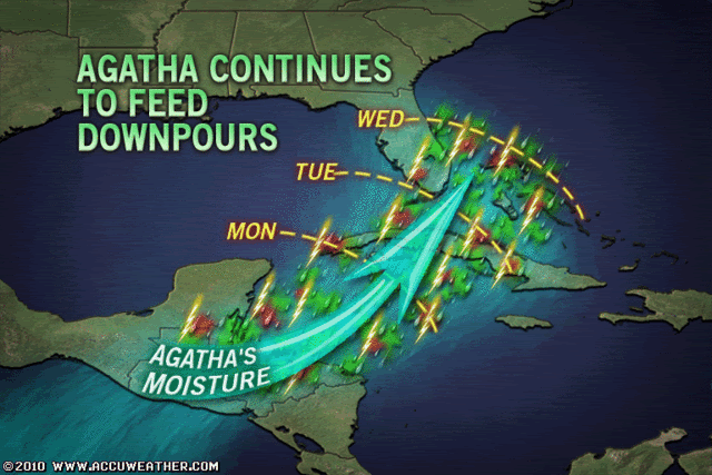
Looks like something might be getting started. There is some mid level spin (I think), but not sure about the surface.

Pressures are still rising at this buoy

Image
http://www.ndbc.noaa.gov/station_page.php?station=42056

Wind shear north of the system is expected 9GFS) to relax a bit for the next 24 t 48 hours before increasing again. You know how believable those wind shear forecasts are though.
0 likes   
M a r k
- - - - -
Join us in chat: Storm2K Chatroom Invite. Android and IOS apps also available.

The posts in this forum are NOT official forecasts and should not be used as such. Posts are NOT endorsed by any professional institution or STORM2K.org. For official information and forecasts, please refer to NHC and NWS products.

User avatar
cycloneye
Admin
Admin
Posts: 145568
Age: 68
Joined: Thu Oct 10, 2002 10:54 am
Location: San Juan, Puerto Rico

Re: Possible GOM/Caribbean development

#62 Postby cycloneye » Mon May 31, 2010 10:39 am

0 likes   
Visit the Caribbean-Central America Weather Thread where you can find at first post web cams,radars
and observations from Caribbean basin members Click Here

User avatar
brunota2003
S2K Supporter
S2K Supporter
Posts: 9476
Age: 34
Joined: Sat Jul 30, 2005 9:56 pm
Location: Stanton, KY...formerly Havelock, NC
Contact:

#63 Postby brunota2003 » Mon May 31, 2010 10:44 am

If there is a llc, then it is extremely broad and weak (note those winds are only 7 mph, or about 5 knots). However, the convection still is persisting (almost what? 4 or 5 hours now?), so it is possible a llc starts working toward the surface, or if there is one, it might start to tighten up a bit.
0 likes   

User avatar
drezee
S2K Supporter
S2K Supporter
Posts: 3664
Joined: Mon Jun 09, 2003 12:49 pm
Location: FL

Re: Possible GOM/Caribbean development

#64 Postby drezee » Mon May 31, 2010 10:49 am

OK, there are different kinds of development...

Having a developing broad area of low pressure, one would expect pressure falls at that distance from the quasi-center.

Having a existing TC crossing over CA, you would not necessarily expect pressure fall at this point. The over all environment pressure is rising. THe High Pressure over the Atlantic is building in. The pressure at that buoy should rise. You should be looking for three things over the next 12-24 hours at that buoy:
1. Are the winds increasing?
2. Are the waves increasing?
3. Is the pressure at the nearest buoy rising slower than the rest of the environment?

1.Y
2. Y
3. Y, nearest buoy between 42056 and high pressure has risen 0.5 faster...

Do not look at this as a broad area of LP...this is a different situation...
0 likes   

User avatar
HURAKAN
Professional-Met
Professional-Met
Posts: 46086
Age: 38
Joined: Thu May 20, 2004 4:34 pm
Location: Key West, FL
Contact:

#65 Postby HURAKAN » Mon May 31, 2010 10:53 am

12z

Image

91L soon?
0 likes   

User avatar
blp
Category 5
Category 5
Posts: 2840
Age: 46
Joined: Thu Sep 09, 2004 7:51 pm
Location: Miami, FL
Contact:

Re: Possible GOM/Caribbean development

#66 Postby blp » Mon May 31, 2010 11:13 am

Shear appears to be easing up in its path.

Image

However, overall shear appears high in the Gulf.

Image

Looks like it has a small opportunity off Yucatan.
0 likes   

User avatar
HURAKAN
Professional-Met
Professional-Met
Posts: 46086
Age: 38
Joined: Thu May 20, 2004 4:34 pm
Location: Key West, FL
Contact:

#67 Postby HURAKAN » Mon May 31, 2010 11:40 am

Image

Accuweather's take
0 likes   

User avatar
alienstorm
Category 1
Category 1
Posts: 496
Joined: Tue Jul 31, 2007 1:29 pm
Location: Miami Fla western suburb

#68 Postby alienstorm » Mon May 31, 2010 12:13 pm

There is something developing there the question is persistence, and how much it can gather before shear tears into it.
0 likes   
Personal Forecast Disclaimer:The posts in this forum are NOT official forecast and should not be used as such. They are just the opinion of the poster and may or may not be backed by sound meteorological data. They are NOT endorsed by any professional institution or storm2k.org. For official information, please refer to the NHC and NWS products.

User avatar
wxman57
Moderator-Pro Met
Moderator-Pro Met
Posts: 22984
Age: 67
Joined: Sat Jun 21, 2003 8:06 pm
Location: Houston, TX (southwest)

Re:

#69 Postby wxman57 » Mon May 31, 2010 1:06 pm

thetruesms wrote:Every time I read through this thread to catch up on it, and start thinking of what I want to post, wxman always comes along and posts more or less exactly what I want to discuss :lol:

Our blob is in a spot where it looks to have a (very small) window before it'll get torn apart heading towards that jet streak. I'll be watching it closely, but more just for rain chances for FL than any serious tropical development.


Sorry. You can post first next time. ;-)

Convection dropping off now. Guidance has changed some since last week. The jet stream isn't dipping as far into the NW Caribbean now.
0 likes   

User avatar
NDG
S2K Supporter
S2K Supporter
Posts: 15446
Joined: Sun Jul 09, 2006 10:14 pm
Location: Orlando, FL

Re: Possible GOM/Caribbean development

#70 Postby NDG » Mon May 31, 2010 1:10 pm

As the day has gone, I have grown not very impressed with this system. There is a vorticity with maybe a very broad & weak low pressure center east of Belize while the convection & H85 vorticity keeps drifting away from it. Surface pressures are not very low in the area, if anything they have gone up in the last 24 hrs.
0 likes   

User avatar
HURAKAN
Professional-Met
Professional-Met
Posts: 46086
Age: 38
Joined: Thu May 20, 2004 4:34 pm
Location: Key West, FL
Contact:

#71 Postby HURAKAN » Mon May 31, 2010 1:10 pm

205 TWD:

A 1010 MB LOW IS CENTERED OFF THE COAST OF BELIZE
NEAR 18N87W DRIFTING N. SCATTERED MODERATE TO ISOLATED STRONG
CONVECTION IS FROM 17N-19N BETWEEN 85W-87W.
0 likes   

User avatar
blp
Category 5
Category 5
Posts: 2840
Age: 46
Joined: Thu Sep 09, 2004 7:51 pm
Location: Miami, FL
Contact:

Re: Possible GOM/Caribbean development

#72 Postby blp » Mon May 31, 2010 1:11 pm

2:05pm Discussion... Low is still off the coast.

CARIBBEAN SEA...
TWO TROPICAL WAVES ARE OVER SOUTH AMERICA AND THE CARIBBEAN SEA.

SEE ABOVE. A 1010 MB LOW IS CENTERED OFF THE COAST OF BELIZE
NEAR 18N87W DRIFTING N.
SCATTERED MODERATE TO ISOLATED STRONG
CONVECTION IS FROM 17N-19N BETWEEN 85W-87W. SCATTERED SHOWERS
ARE OVER THE NW CARIBBEAN N OF 20N BETWEEN 78W-87W. FURTHER S...
SCATTERED MODERATE TO ISOLATED STRONG CONVECTION IS OVER PANAMA
FROM 8N-11N BETWEEN 77W-80W. FURTHER E...THE TAIL END OF A
SURFACE TROUGH FROM N OF THE LEEWARD ISLANDS TO HISPANIOLA IS
PRODUCING ISOLATED MODERATE CONVECTION FROM 17N-21N BETWEEN
66W-71W. IN THE UPPER LEVELS...AN UPPER LEVEL HIGH IS CENTERED
OVER THE W CARIBBEAN NEAR 15N82W. ANOTHER UPPER LEVEL HIGH IS
CENTERED E OF THE LEEWARD ISLANDS NEAR 16N58W. SUBSIDENCE IS
NOTED IN THE VICINITY OF BOTH UPPER LEVEL HIGHS WHILE UPPER
LEVEL MOISTURE IS NOTED ELSEWHERE. EXPECT OVER THE NEXT 24
HOURS...FOR RAIN AND SHOWERS TO DOT MOST OF THE CARIBBEAN DUE TO
THE EXISTING SURFACE FEATURES.
0 likes   

User avatar
cycloneye
Admin
Admin
Posts: 145568
Age: 68
Joined: Thu Oct 10, 2002 10:54 am
Location: San Juan, Puerto Rico

Re: Possible GOM/Caribbean development

#73 Postby cycloneye » Mon May 31, 2010 1:22 pm

:uarrow: It seems that the folks at NHC are not in a hurry to have invest up as they want to wait for convection to persist a bit more.
0 likes   
Visit the Caribbean-Central America Weather Thread where you can find at first post web cams,radars
and observations from Caribbean basin members Click Here

User avatar
blp
Category 5
Category 5
Posts: 2840
Age: 46
Joined: Thu Sep 09, 2004 7:51 pm
Location: Miami, FL
Contact:

Re: Possible GOM/Caribbean development

#74 Postby blp » Mon May 31, 2010 1:26 pm

Interesting. Did not get all of the area in question.

Image
0 likes   

User avatar
NDG
S2K Supporter
S2K Supporter
Posts: 15446
Joined: Sun Jul 09, 2006 10:14 pm
Location: Orlando, FL

Re: Possible GOM/Caribbean development

#75 Postby NDG » Mon May 31, 2010 1:51 pm

cycloneye wrote::uarrow: It seems that the folks at NHC are not in a hurry to have invest up as they want to wait for convection to persist a bit more.


Probably more because it has not global model support also.
0 likes   

User avatar
Blown Away
S2K Supporter
S2K Supporter
Posts: 10152
Joined: Wed May 26, 2004 6:17 am

Re: Possible GOM/Caribbean development

#76 Postby Blown Away » Mon May 31, 2010 1:57 pm

Some deep reds beginning to build again, looks better than 90L did.
http://www.ssd.noaa.gov/goes/flt/t1/loop-avn.html
0 likes   
Hurricane Eye Experience: David 79, Irene 99, Frances 04, Jeanne 04, Wilma 05... EYE COMING MY WAY IN 2024…
Hurricane Brush Experience: Andrew 92, Erin 95, Floyd 99, Matthew 16, Irma 17, Ian 22, Nicole 22…

User avatar
wxman57
Moderator-Pro Met
Moderator-Pro Met
Posts: 22984
Age: 67
Joined: Sat Jun 21, 2003 8:06 pm
Location: Houston, TX (southwest)

Re: Possible GOM/Caribbean development

#77 Postby wxman57 » Mon May 31, 2010 2:08 pm

Surface obs do not indicate any evidence of an LLC, even a broad one. Obs at Roatan are almost certainly land/sea breeze effect. They're 5 kts or less and not blowing steadily from any direction. Other obs north of there are from the ENE-ESE. Probably most telling is the pressure at the NW Caribbean buoy near 20N/85W which has been rising for 3-5 hours as the storms approached. Not a sign of development. Wind shear steadily increases as it moves north, so it looks like just some rain for western Cuba tonight and Florida on Wednesday.

Image
Last edited by wxman57 on Mon May 31, 2010 2:08 pm, edited 1 time in total.
0 likes   

User avatar
brunota2003
S2K Supporter
S2K Supporter
Posts: 9476
Age: 34
Joined: Sat Jul 30, 2005 9:56 pm
Location: Stanton, KY...formerly Havelock, NC
Contact:

#78 Postby brunota2003 » Mon May 31, 2010 2:08 pm

The pressure is starting to fall at the buoy now.

I also believe that any circulation (mid/upper level) is to the S or SW of the convection.
0 likes   

User avatar
tailgater
S2K Supporter
S2K Supporter
Posts: 3339
Joined: Sun Jul 11, 2004 9:13 pm
Location: St. Amant La.

Re: Possible GOM/Caribbean development

#79 Postby tailgater » Mon May 31, 2010 2:38 pm

Interesting MIMIC loop shows this area starting to break away from that large SW flow it had been caught up in.
http://cimss.ssec.wisc.edu/tropic/real- ... /main.html
0 likes   
The following post is NOT an official forecast and should not be used as such. It is just the opinion of the poster and may or may not be backed by sound meteorological data. It is NOT endorsed by any professional institution including storm2k.org For Official Information please refer to the NHC and NWS products.

User avatar
littlevince
S2K Supporter
S2K Supporter
Posts: 768
Joined: Fri Oct 21, 2005 10:45 am
Location: Portugal

Re: Possible GOM/Caribbean development

#80 Postby littlevince » Mon May 31, 2010 2:47 pm

Surface observations:

Image
0 likes   


Return to “Talkin' Tropics”

Who is online

Users browsing this forum: Cpv17, IsabelaWeather, Killjoy12, ljmac75 and 66 guests