Late Season Development W. Carib. (Is invest 91L)

This is the general tropical discussion area. Anyone can take their shot at predicting a storms path.

Moderator: S2k Moderators

Forum rules

The posts in this forum are NOT official forecasts and should not be used as such. They are just the opinion of the poster and may or may not be backed by sound meteorological data. They are NOT endorsed by any professional institution or STORM2K. For official information, please refer to products from the National Hurricane Center and National Weather Service.

Help Support Storm2K
Message
Author
MiamiensisWx

Re: Late Season Development W. Carib. GFS & CMC

#61 Postby MiamiensisWx » Sat Oct 18, 2008 4:24 pm

blp wrote:I agree.... I am thinking that with the Low now offshore they will probably bring the code yellow back up.

It's an error... it's still Code Yellow:

http://www.nhc.noaa.gov/gtwo_atl.shtml
0 likes   

jinftl
Category 5
Category 5
Posts: 4312
Joined: Tue Aug 31, 2004 4:47 pm
Location: fort lauderdale, fl

Re:

#62 Postby jinftl » Sat Oct 18, 2008 4:52 pm

Probably way to soon to get that specific with a forecast for something that has not even formed yet. The NHC gives the area less than a 20% chance of development in the next 48 hours. Forecasting tropical storm conditions later next week is even more speculative.

This is not even an invest yet....it may not materialize into much of anything....or it could be become a nuisance storm/beneficial rainmaker, or a more serious threat to contend with....and that could be for some areas of florida, all areas, or no areas. Could very well head into Cuba as well. Alot of the impacts on florida will also be a function of how big (in size) this system may become...that will determine how much of a rainmaker this could be....and how big of a windfield (if any) there will be.

Once...and if...a low pressure center forms, we will have a better sense of its movement, strength, and the upper air dynamics at the time. Any low pressure that develops will be influenced by fronts/troughs, upper level winds, etc....but way too soon to really know for sure what will aid in development, and what will deter it.


Even a week before landfall with Wilma, the expectation was for a weakening storm as she entered the Gulf...instead, once emerging from the Yucatan, Wilma strengthened pretty much all the way to landfall in Florida...with a huge, expanding windfield...even dragging a 'real' cold front behind her. Never know how all the dynamics will play out since timing and location are so key.

NWS TPC/NATIONAL HURRICANE CENTER MIAMI FL
5 PM EDT MON OCT 17 2005
ONCEWILMA GETS INTO THE GULF OF MEXICO...THE UPPER FLOW WILL BECOME
MORE HOSTILE AS SHEAR INCREASES...AND SOME WEAKENING IS THEREFORE
EXPECTED AT THAT TIME.


Tampa Bay Hurricane wrote:So after reading Miami's analysis, and also good call gatorcane on td 16's remnants remaining,

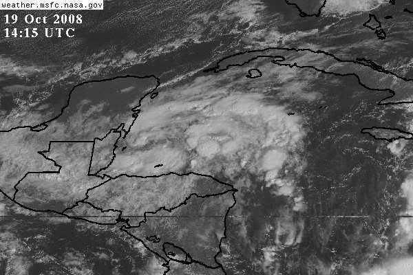
Would it be reasonable to say that there is a high chance (given the heavy
convection in the NW Caribbean) of a weak sheared tropical storm
forming (as explained in Miami's analysis of the shear
vectors/westerlies shearing a northward moving system) and moving northeast into the peninsula mainly as a rain maker
but with hybrid characterisics and winds of 40-50 mph?
Similar to Hybrid-Tropical Storm Gabrielle of 2001 (70 mph landfall in venice near sarasota
with subtropical/hybrid characteristics in september of that year)- but winds of 40-50 mph NOT
70 mph??
0 likes   

User avatar
wxman57
Moderator-Pro Met
Moderator-Pro Met
Posts: 22984
Age: 67
Joined: Sat Jun 21, 2003 8:06 pm
Location: Houston, TX (southwest)

Re: Late Season Development W. Carib. GFS & CMC

#63 Postby wxman57 » Sat Oct 18, 2008 5:19 pm

Looks like it's dissipating. I don't think it's anything to be concerned about, unless you're in Haiti/DR and getting more rain.
0 likes   

jinftl
Category 5
Category 5
Posts: 4312
Joined: Tue Aug 31, 2004 4:47 pm
Location: fort lauderdale, fl

Re: Late Season Development W. Carib. GFS & CMC

#64 Postby jinftl » Sat Oct 18, 2008 5:29 pm

Had it even formed yet...LOL....keep in mind, the models are talking at least a few days out before development takes place. Not even an invest yet....so not sure anything has happened today to sound the 'all clear', esp since there is nothing to sound it on right now!

Dr. Jeff Master's update today:
Wind shear is expected to be low over most of the Caribbean during the coming week, and we need to watch the Western Caribbean for tropical storm development. The GFS and Canadian computer models are predicting the development of a tropical depression in the northwestern Caribbean near the western tip of Cuba 5-7 days from now. The other computer models predict that wind shear will be too high in this region to allow a tropical cyclone to develop.

If a storm did develop in this region, it would likely move north or northeastward and affect the Gulf Coast of Florida. The likelihood of a tropical storm in the Gulf of Mexico over the next ten days is about 20%, and is about 40% in the Caribbean Sea.


http://www.wunderground.com/blog/JeffMasters/comment.html?entrynum=1131&tstamp=200810


wxman57 wrote:Looks like it's dissipating. I don't think it's anything to be concerned about, unless you're in Haiti/DR and getting more rain.
0 likes   

User avatar
Blown Away
S2K Supporter
S2K Supporter
Posts: 10154
Joined: Wed May 26, 2004 6:17 am

Re: Late Season Development W. Carib. GFS & CMC

#65 Postby Blown Away » Sat Oct 18, 2008 6:17 pm

jinftl wrote:Had it even formed yet...LOL....keep in mind, the models are talking at least a few days out before development takes place. Not even an invest yet....so not sure anything has happened today to sound the 'all clear', esp since there is nothing to sound it on right now!

Dr. Jeff Master's update today:
Wind shear is expected to be low over most of the Caribbean during the coming week, and we need to watch the Western Caribbean for tropical storm development. The GFS and Canadian computer models are predicting the development of a tropical depression in the northwestern Caribbean near the western tip of Cuba 5-7 days from now. The other computer models predict that wind shear will be too high in this region to allow a tropical cyclone to develop.

If a storm did develop in this region, it would likely move north or northeastward and affect the Gulf Coast of Florida. The likelihood of a tropical storm in the Gulf of Mexico over the next ten days is about 20%, and is about 40% in the Caribbean Sea.

http://www.wunderground.com/blog/JeffMasters/comment.html?entrynum=1131&tstamp=200810
wxman57 wrote:Looks like it's dissipating. I don't think it's anything to be concerned about, unless you're in Haiti/DR and getting more rain.


Wxman57 is referring to the low just SW of Haiti, and it does appear to be dissipating. I think most are referring to the removal of the "Code Yellow" for the area just off the Yucatan.

BTW, the convection is starting to pop around the area of low pressure just on/off the Yucatan coast.
http://www.ssd.noaa.gov/goes/east/carb/loop-avn.html
0 likes   

User avatar
Blown Away
S2K Supporter
S2K Supporter
Posts: 10154
Joined: Wed May 26, 2004 6:17 am

Re: Late Season Development W. Carib. GFS & CMC

#66 Postby Blown Away » Sat Oct 18, 2008 6:21 pm

MiamiensisWx wrote:
blp wrote:I agree.... I am thinking that with the Low now offshore they will probably bring the code yellow back up.

It's an error... it's still Code Yellow:

http://www.nhc.noaa.gov/gtwo_atl.shtml


Your right, I could not understand why they would have removed "Code Yellow" from this area.

The NCEP has a low moving from the NW Caribbean to the Big Bend Florida area in 7 days.
http://www.ncep.noaa.gov/nationalmaps/
0 likes   

User avatar
HURAKAN
Professional-Met
Professional-Met
Posts: 46086
Age: 38
Joined: Thu May 20, 2004 4:34 pm
Location: Key West, FL
Contact:

#67 Postby HURAKAN » Sat Oct 18, 2008 6:46 pm

0 likes   

User avatar
HURAKAN
Professional-Met
Professional-Met
Posts: 46086
Age: 38
Joined: Thu May 20, 2004 4:34 pm
Location: Key West, FL
Contact:

Re: Late Season Development W. Carib. GFS & CMC

#68 Postby HURAKAN » Sat Oct 18, 2008 6:46 pm

TROPICAL WEATHER OUTLOOK
NWS TPC/NATIONAL HURRICANE CENTER MIAMI FL
800 PM EDT SAT OCT 18 2008

FOR THE NORTH ATLANTIC...CARIBBEAN SEA AND THE GULF OF MEXICO...

THE REMNANTS OF OMAR ARE CENTERED ABOUT 855 MILES EAST OF BERMUDA.
RE-DEVELOPMENT AS A TROPICAL CYCLONE IS NOT EXPECTED.

AN AREA OF DISTURBED WEATHER CONTINUES OVER THE NORTHWESTERN
CARIBBEAN SEA IN ASSOCIATION WITH A BROAD AREA OF LOW PRESSURE.
LITTLE MOTION IS ANTICIPATED AND DEVELOPMENT...IF ANY...WILL BE
SLOW TO OCCUR. THIS SYSTEM WILL LIKELY PRODUCE CLOUDINESS AND
HEAVY RAINS OVER PORTIONS OF CENTRAL AMERICA...PRIMARILY OVER
BELIZE AND THE EASTERN YUCATAN PENINSULA OF MEXICO.


CLOUDINESS AND SHOWERS ASSOCIATED WITH A TROPICAL WAVE CENTERED
ABOUT 800 MILES WEST OF THE CAPE VERDE ISLANDS REMAIN DISORGANIZED.
UPPER-LEVEL WINDS ARE NOT CONDUCIVE FOR DEVELOPMENT AT THIS TIME.

SHOWER ACTIVITY ASSOCIATED WITH THE AREA OF DISTURBED WEATHER OVER
THE CENTRAL CARIBBEAN SEA HAS DIMINISHED.

ELSEWHERE...TROPICAL CYCLONE FORMATION IS NOT EXPECTED DURING THE
NEXT 48 HOURS.

$$

FORECASTER BEVEN
0 likes   

Sanibel
Category 5
Category 5
Posts: 10375
Joined: Mon Aug 30, 2004 11:06 pm
Location: Offshore SW Florida

Re: Late Season Development W. Carib. GFS & CMC

#69 Postby Sanibel » Sat Oct 18, 2008 8:19 pm

I'm pretty sure the Central America LOW has relocated offshore. I think the trough finally pulled it as I was speculating. Could have some business sooner than we thought here.

Edit: Not sure where the center is.
0 likes   

User avatar
TheEuropean
Professional-Met
Professional-Met
Posts: 1796
Age: 59
Joined: Tue Sep 20, 2005 3:17 pm
Location: Voerde, Germany
Contact:

#70 Postby TheEuropean » Sun Oct 19, 2008 12:00 am

18/2345 UTC 18.4N 85.5W TOO WEAK INVEST -- Atlantic Ocean
0 likes   

User avatar
Thunder44
Category 5
Category 5
Posts: 5922
Age: 44
Joined: Mon Jun 09, 2003 7:53 pm
Location: New York City

Re: Late Season Development W. Carib. GFS & CMC

#71 Postby Thunder44 » Sun Oct 19, 2008 3:59 am

000
ABNT20 KNHC 190543
TWOAT
TROPICAL WEATHER OUTLOOK
NWS TPC/NATIONAL HURRICANE CENTER MIAMI FL
200 AM EDT SUN OCT 19 2008

FOR THE NORTH ATLANTIC...CARIBBEAN SEA AND THE GULF OF MEXICO...

THE REMNANTS OF OMAR ARE CENTERED ABOUT 900 MILES EAST-NORTHEAST OF
BERMUDA. RE-DEVELOPMENT AS A TROPICAL CYCLONE IS NOT EXPECTED.

AN AREA OF DISTURBED WEATHER IS OVER THE NORTHWESTERN CARIBBEAN
SEA...ASSOCIATED WITH A BROAD AREA OF LOW PRESSURE. LITTLE MOTION
IS ANTICIPATED AND DEVELOPMENT...IF ANY...WILL BE SLOW TO OCCUR.
THIS SYSTEM WILL LIKELY PRODUCE CLOUDINESS AND HEAVY RAINS OVER
PORTIONS OF CENTRAL AMERICA...PRIMARILY OVER BELIZE AND THE EASTERN
YUCATAN PENINSULA OF MEXICO.


CLOUDINESS AND SHOWERS ASSOCIATED WITH A TROPICAL WAVE CENTERED
ABOUT 900 MILES WEST OF THE CAPE VERDE ISLANDS REMAIN DISORGANIZED.
UPPER-LEVEL WINDS ARE NOT CONDUCIVE FOR DEVELOPMENT AT THIS TIME.

ELSEWHERE...TROPICAL CYCLONE FORMATION IS NOT EXPECTED DURING THE
NEXT 48 HOURS.

$$

FORECASTER BEVEN
0 likes   

User avatar
TheEuropean
Professional-Met
Professional-Met
Posts: 1796
Age: 59
Joined: Tue Sep 20, 2005 3:17 pm
Location: Voerde, Germany
Contact:

#72 Postby TheEuropean » Sun Oct 19, 2008 4:56 am

19/0545 UTC 18.3N 87.6W TOO WEAK INVEST -- Atlantic Ocean
0 likes   

User avatar
Thunder44
Category 5
Category 5
Posts: 5922
Age: 44
Joined: Mon Jun 09, 2003 7:53 pm
Location: New York City

Re: Late Season Development W. Carib. GFS & CMC

#73 Postby Thunder44 » Sun Oct 19, 2008 6:58 am

ZCZC MIATWOAT ALL
TTAA00 KNHC DDHHMM
TROPICAL WEATHER OUTLOOK
NWS TPC/NATIONAL HURRICANE CENTER MIAMI FL
800 AM EDT SUN OCT 19 2008

FOR THE NORTH ATLANTIC...CARIBBEAN SEA AND THE GULF OF MEXICO...

1. SHOWERS AND THUNDERSTORMS REMAIN DISORGANIZED IN ASSOCIATION WITH
A NEARLY-STATIONARY BROAD OF LOW PRESSURE AREA LOCATED OVER THE
NORTHWESTERN CARIBBEAN SEA. DEVELOPMENT OF THIS SYSTEM...IF
ANY...IS EXPECTED TO BE SLOW TO OCCUR. REGARDLESS OF
DEVELOPMENT...THE LOW WILL LIKELY PRODUCE CLOUDINESS AND HEAVY
RAINFALL OVER PORTIONS OF CENTRAL AMERICA...PRIMARILY OVER BELIZE
AND THE EASTERN YUCATAN PENINSULA OF MEXICO DURING THE NEXT COUPLE
OF DAYS.

ELSEWHERE...TROPICAL CYCLONE FORMATION IS NOT EXPECTED DURING THE
NEXT 48 HOURS.

$$

FORECASTER BROWN
0 likes   

User avatar
gatorcane
S2K Supporter
S2K Supporter
Posts: 23692
Age: 47
Joined: Sun Mar 13, 2005 3:54 pm
Location: Boca Raton, FL

Re: Late Season Development W. Carib. GFS & CMC

#74 Postby gatorcane » Sun Oct 19, 2008 9:03 am

No doubt this will be a numbered invest by the end of the day:

Image

TAFB surface plot at 72 hours. Doesn't move much:

Image
0 likes   

User avatar
CourierPR
Category 5
Category 5
Posts: 1335
Age: 71
Joined: Tue Aug 31, 2004 7:53 pm
Location: Pompano Beach, Florida

Re: Late Season Development W. Carib. GFS & CMC

#75 Postby CourierPR » Sun Oct 19, 2008 9:07 am

Gatorcane, it appears to me that slow organization is taking place. What say you?
0 likes   

User avatar
gatorcane
S2K Supporter
S2K Supporter
Posts: 23692
Age: 47
Joined: Sun Mar 13, 2005 3:54 pm
Location: Boca Raton, FL

Re: Late Season Development W. Carib. GFS & CMC

#76 Postby gatorcane » Sun Oct 19, 2008 9:09 am

CourierPR wrote:Gatorcane, it appears to me that slow organization is taking place. What say you?


Yes, absolutely. The NHC has given it an "INVEST" tag but not an official number yet. When it gets a number it means its more organized.
0 likes   

Sanibel
Category 5
Category 5
Posts: 10375
Joined: Mon Aug 30, 2004 11:06 pm
Location: Offshore SW Florida

Re: Late Season Development W. Carib. GFS & CMC

#77 Postby Sanibel » Sun Oct 19, 2008 9:17 am

Cold front this am in Florida. Our Belize LOW has warmed slightly. I think the MJO is weakening or in a d-min er something. The disturbance will tell us if it refires. Warmer but better organization today. Rest of Atlantic has weakened in convection like MJO weakening.
0 likes   

User avatar
HURAKAN
Professional-Met
Professional-Met
Posts: 46086
Age: 38
Joined: Thu May 20, 2004 4:34 pm
Location: Key West, FL
Contact:

#78 Postby HURAKAN » Sun Oct 19, 2008 9:20 am

0 likes   

User avatar
HURAKAN
Professional-Met
Professional-Met
Posts: 46086
Age: 38
Joined: Thu May 20, 2004 4:34 pm
Location: Key West, FL
Contact:

#79 Postby HURAKAN » Sun Oct 19, 2008 9:21 am

19/1145 UTC 17.6N 87.3W TOO WEAK INVEST -- Atlantic Ocean
0 likes   

User avatar
HURAKAN
Professional-Met
Professional-Met
Posts: 46086
Age: 38
Joined: Thu May 20, 2004 4:34 pm
Location: Key West, FL
Contact:

#80 Postby HURAKAN » Sun Oct 19, 2008 9:37 am

Image
0 likes   


Return to “Talkin' Tropics”

Who is online

Users browsing this forum: Google Adsense [Bot], jgh, Lizzytiz1, NotSparta, Tak5, weatherSnoop and 75 guests