2025 Global Model Runs Discussion (Out thru day 16)

This is the general tropical discussion area. Anyone can take their shot at predicting a storms path.

Moderator: S2k Moderators

Forum rules

The posts in this forum are NOT official forecasts and should not be used as such. They are just the opinion of the poster and may or may not be backed by sound meteorological data. They are NOT endorsed by any professional institution or STORM2K. For official information, please refer to products from the National Hurricane Center and National Weather Service.

Help Support Storm2K
Message
Author
TomballEd
Category 2
Category 2
Posts: 792
Age: 61
Joined: Wed Aug 16, 2023 4:52 pm
Location: Spring/Klein area, not Tomball

Re: 2025 Global Model Runs Discussion (Out thru day 16)

#561 Postby TomballEd » Wed Aug 06, 2025 10:06 am

SconnieCane wrote:
cycloneye wrote:Here we go again with the ups and downs AnnularCane. 06z GFS did not develop that wave as it crossed thru PR, DR, Haiti and Cuba.


It's uncanny how often the "GA shredder track" plays havoc with the models. The Euro run in your prior post is also a perfect example. The only reason it has a system there is because it develops it before it gets to Hispaniola.


From multiple days out, it takes only a small shift in track to graze the Greater Antilles rather than hit them full on and be weakened/destroyed. Or I would never trust a model a week out to accurately predict a hit or miss. Plus the west side of Cuba has smaller ridges than the east side of the island. Charley is an example of a storm not badly weakened by Cuba.
2 likes   

User avatar
StormWeather
Category 1
Category 1
Posts: 265
Joined: Wed Jun 05, 2024 2:34 pm

Re: 2025 Global Model Runs Discussion (Out thru day 16)

#562 Postby StormWeather » Wed Aug 06, 2025 11:33 am

12Z GFS today delays the development of our current 20/60 AoI tropical wave, but it does develop the wave behind it within 7 days from current time. If this suggestion continues to persist in the GFS in the following runs, it will have my attention because it is within a week’s time as of now.

Edit: actually the GFS initially develops the new wave into a 998 mb system by 12Z August 12th, which is 6 days out.

Edit 2: our current 20/60 AoI eventually develops into a weak 1001 mb system around 35N, 60W. It stays weak.
1 likes   
Just an average cyclone tracker

The posts in this forum are NOT official forecasts and should not be used as such. They are just the opinion of the poster and may or may not be backed by sound meteorological data. They are NOT endorsed by any professional institution or storm2k.org. For official information, please refer to the NHC and NWS products

OURAGAN
Category 1
Category 1
Posts: 455
Joined: Sat Aug 07, 2004 12:18 pm
Location: GUADELOUPE

Re: 2025 Global Model Runs Discussion (Out thru day 16)

#563 Postby OURAGAN » Wed Aug 06, 2025 11:45 am

975 MB, august15, east of lesser Antilles.
0 likes   

hurricane2025
Tropical Storm
Tropical Storm
Posts: 217
Joined: Thu Apr 08, 2021 10:36 am

Re: 2025 Global Model Runs Discussion (Out thru day 16)

#564 Postby hurricane2025 » Wed Aug 06, 2025 11:50 am

Gfs is so inconsistent don’t even look at past 180 hours
2 likes   

TomballEd
Category 2
Category 2
Posts: 792
Age: 61
Joined: Wed Aug 16, 2023 4:52 pm
Location: Spring/Klein area, not Tomball

Re: 2025 Global Model Runs Discussion (Out thru day 16)

#565 Postby TomballEd » Wed Aug 06, 2025 12:11 pm

GFS op shows a weak moisture/vorticity max ahead of the 40% Mandarin 10% of the 6Z GEFS (same for Euro ensembles) develop that. That leads to GFS ensemble members producing 2.5 Gulf storms/hurricanes

Could being the operative word. 10% is not screaming ensemble support.

Edit to add: The system behind the 40% Mandarin seems to have a future. Too early to guess which is right, but 0Z Euro ensembles show some track spread on that possible system the GFS family doesn't. 5% of the Canadian ensembles (shown below) hit Corpus Christi in 9 days (for entertainment purposes only)

Image
4 likes   

TomballEd
Category 2
Category 2
Posts: 792
Age: 61
Joined: Wed Aug 16, 2023 4:52 pm
Location: Spring/Klein area, not Tomball

Re: 2025 Global Model Runs Discussion (Out thru day 16)

#566 Postby TomballEd » Wed Aug 06, 2025 12:40 pm

2 likes   

BobHarlem
Category 5
Category 5
Posts: 2249
Joined: Thu Oct 20, 2005 6:11 pm

Re: 2025 Global Model Runs Discussion (Out thru day 16)

#567 Postby BobHarlem » Wed Aug 06, 2025 1:03 pm

Fairly large change on the 12z Euro, in now recurves the wave behind the current area of interest in the Atlantic (edit: now invest 96L) well before the lesser Antilles and east of Bermuda. Basically following the path of the first wave, although there may be a sign of a stall toward the end of the run. Euro needs a few more runs to cook and the wave actually in the Atlantic, but I'll take an August fish barrel, just no Bermuda or Canada please. Euro AI is the clickbait run for this afternoon.
Last edited by BobHarlem on Wed Aug 06, 2025 2:05 pm, edited 5 times in total.
3 likes   

OURAGAN
Category 1
Category 1
Posts: 455
Joined: Sat Aug 07, 2004 12:18 pm
Location: GUADELOUPE

Re: 2025 Global Model Runs Discussion (Out thru day 16)

#568 Postby OURAGAN » Wed Aug 06, 2025 1:06 pm

Not GFS
0 likes   

Stratton23
Category 5
Category 5
Posts: 2569
Joined: Fri Jul 21, 2023 10:59 pm
Location: Katy, Tx

Re: 2025 Global Model Runs Discussion (Out thru day 16)

#569 Postby Stratton23 » Wed Aug 06, 2025 2:52 pm

Sneaky little tropical wave SE of the leeward islands, TomballEd posted the GEFS run above, some members in the gulf in 8-9 days, worth watching despite model support being low and nothing official from the NHC, wind shear is favorable in the caribbean, mid level shear is moderate to low , also not alot of dry air, trade winds are fast though, still worth keeping a close eye on, GFS has shown attempts at consolidating a vortex as it moves through the caribbean
0 likes   

Cachondo23
Tropical Depression
Tropical Depression
Posts: 88
Joined: Wed May 25, 2022 5:56 am

Re: 2025 Global Model Runs Discussion (Out thru day 16)

#570 Postby Cachondo23 » Wed Aug 06, 2025 3:18 pm

BobHarlem wrote:Fairly large change on the 12z Euro, in now recurves the wave behind the current area of interest in the Atlantic (edit: now invest 96L) well before the lesser Antilles and east of Bermuda. Basically following the path of the first wave, although there may be a sign of a stall toward the end of the run. Euro needs a few more runs to cook and the wave actually in the Atlantic, but I'll take an August fish barrel, just no Bermuda or Canada please. Euro AI is the clickbait run for this afternoon.

Is today’s 12z Euro not available in Tropical Tidbits? It stays at 06z
0 likes   

User avatar
WaveBreaking
Category 2
Category 2
Posts: 589
Joined: Sun Jun 30, 2024 11:33 am
Location: US

Re: 2025 Global Model Runs Discussion (Out thru day 16)

#571 Postby WaveBreaking » Wed Aug 06, 2025 3:20 pm

Cachondo23 wrote:
BobHarlem wrote:Fairly large change on the 12z Euro, in now recurves the wave behind the current area of interest in the Atlantic (edit: now invest 96L) well before the lesser Antilles and east of Bermuda. Basically following the path of the first wave, although there may be a sign of a stall toward the end of the run. Euro needs a few more runs to cook and the wave actually in the Atlantic, but I'll take an August fish barrel, just no Bermuda or Canada please. Euro AI is the clickbait run for this afternoon.

Is today’s 12z Euro not available in Tropical Tidbits? It stays at 06z


BobHarlem probably looked at the 12Z Euro on pivotalweather.com, which gets Euro model data faster than Tropical Tidbits.
0 likes   
I am NOT a professional meteorologist, so take all of my posts with a grain of salt. My opinions are mine and mine alone.

User avatar
Cpv17
Category 5
Category 5
Posts: 5016
Joined: Wed Dec 07, 2016 2:24 pm
Location: Wharton/El Campo, TX

Re: 2025 Global Model Runs Discussion (Out thru day 16)

#572 Postby Cpv17 » Wed Aug 06, 2025 3:20 pm

Cachondo23 wrote:
BobHarlem wrote:Fairly large change on the 12z Euro, in now recurves the wave behind the current area of interest in the Atlantic (edit: now invest 96L) well before the lesser Antilles and east of Bermuda. Basically following the path of the first wave, although there may be a sign of a stall toward the end of the run. Euro needs a few more runs to cook and the wave actually in the Atlantic, but I'll take an August fish barrel, just no Bermuda or Canada please. Euro AI is the clickbait run for this afternoon.

Is today’s 12z Euro not available in Tropical Tidbits? It stays at 06z


Tropical Tidbits is slow and has been having a lot of issues for me over the past few months.
2 likes   

BobHarlem
Category 5
Category 5
Posts: 2249
Joined: Thu Oct 20, 2005 6:11 pm

Re: 2025 Global Model Runs Discussion (Out thru day 16)

#573 Postby BobHarlem » Wed Aug 06, 2025 3:51 pm

Cachondo23 wrote:
BobHarlem wrote:Fairly large change on the 12z Euro, in now recurves the wave behind the current area of interest in the Atlantic (edit: now invest 96L) well before the lesser Antilles and east of Bermuda. Basically following the path of the first wave, although there may be a sign of a stall toward the end of the run. Euro needs a few more runs to cook and the wave actually in the Atlantic, but I'll take an August fish barrel, just no Bermuda or Canada please. Euro AI is the clickbait run for this afternoon.

Is today’s 12z Euro not available in Tropical Tidbits? It stays at 06z


Tidbits is generally having issues, I love it, but I don't think Levi gets as much time to work on it as he used to back at FSU. Tidbits has been usually slower (and sometimes misses frames/runs) than some of the alternates. One thing about tropics links, always have backups and alternate sources.

Pivotal Euro link: https://www.pivotalweather.com/model.ph ... &dpdt=&mc=
Euro AI: https://www.pivotalweather.com/model.ph ... &dpdt=&mc=
GFS: https://www.pivotalweather.com/model.ph ... &dpdt=&mc=
Canadian: https://www.pivotalweather.com/model.ph ... &dpdt=&mc=
Icon: https://www.pivotalweather.com/model.ph ... &dpdt=&mc=
5 likes   

BobHarlem
Category 5
Category 5
Posts: 2249
Joined: Thu Oct 20, 2005 6:11 pm

Re: 2025 Global Model Runs Discussion (Out thru day 16)

#574 Postby BobHarlem » Wed Aug 06, 2025 4:26 pm

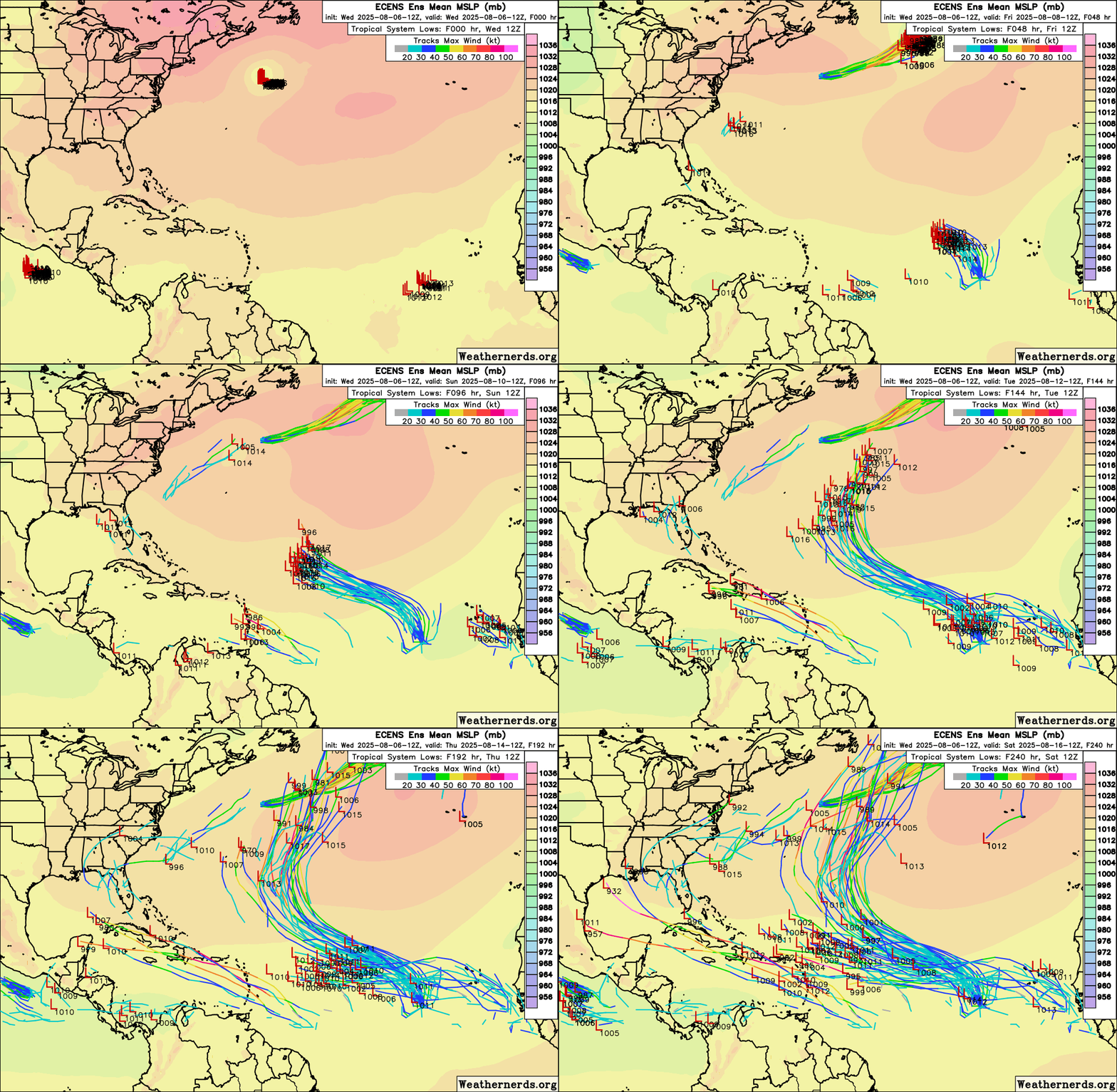
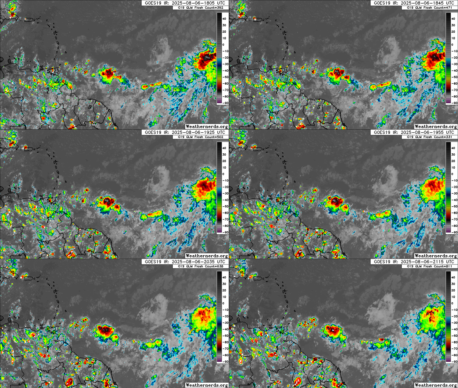
12z Euro Ensembles, animated to make out the difference between 96l and the followup wave easier. Yeah that thing east of the leewards is interesting too. GFS operational showed it some as well.

Image

potential "under the radar" wave east of the leewards:

Image
5 likes   

User avatar
Hurricaneman
Category 5
Category 5
Posts: 7374
Age: 45
Joined: Tue Aug 31, 2004 3:24 pm
Location: central florida

Re: 2025 Global Model Runs Discussion (Out thru day 16)

#575 Postby Hurricaneman » Wed Aug 06, 2025 4:54 pm

That area east of the islands needs to be watched, could be a sleeper, wouldn’t be surprised to see a lemon issued at 8 pm or at latest 8 am
3 likes   

ChrisH-UK
Category 2
Category 2
Posts: 636
Joined: Sat May 29, 2021 8:22 am

Re: 2025 Global Model Runs Discussion (Out thru day 16)

#576 Postby ChrisH-UK » Wed Aug 06, 2025 5:00 pm

BobHarlem wrote:12z Euro Ensembles, animated to make out the difference between 96l and the followup wave easier. Yeah that thing east of the leewards is interesting too. GFS operational showed it some as well.

https://i.postimg.cc/YqQZ37LL/43319939.gif

potential "under the radar" wave east of the leewards:

https://i.postimg.cc/J4TJSDkf/48984470.gif


The GFS has it rolling in to the Caribbean worth keeping an eye on it.

Image
3 likes   

Stratton23
Category 5
Category 5
Posts: 2569
Joined: Fri Jul 21, 2023 10:59 pm
Location: Katy, Tx

Re: 2025 Global Model Runs Discussion (Out thru day 16)

#577 Postby Stratton23 » Wed Aug 06, 2025 5:45 pm

Tropics really exploding on the 18z GFS lol, but that little wave near the leeward island is definitely getting my attention more
2 likes   

BobHarlem
Category 5
Category 5
Posts: 2249
Joined: Thu Oct 20, 2005 6:11 pm

Re: 2025 Global Model Runs Discussion (Out thru day 16)

#578 Postby BobHarlem » Wed Aug 06, 2025 5:50 pm

Stratton23 wrote:Tropics really exploding on the 18z GFS lol, but that little wave near the leeward island is definitely getting my attention more


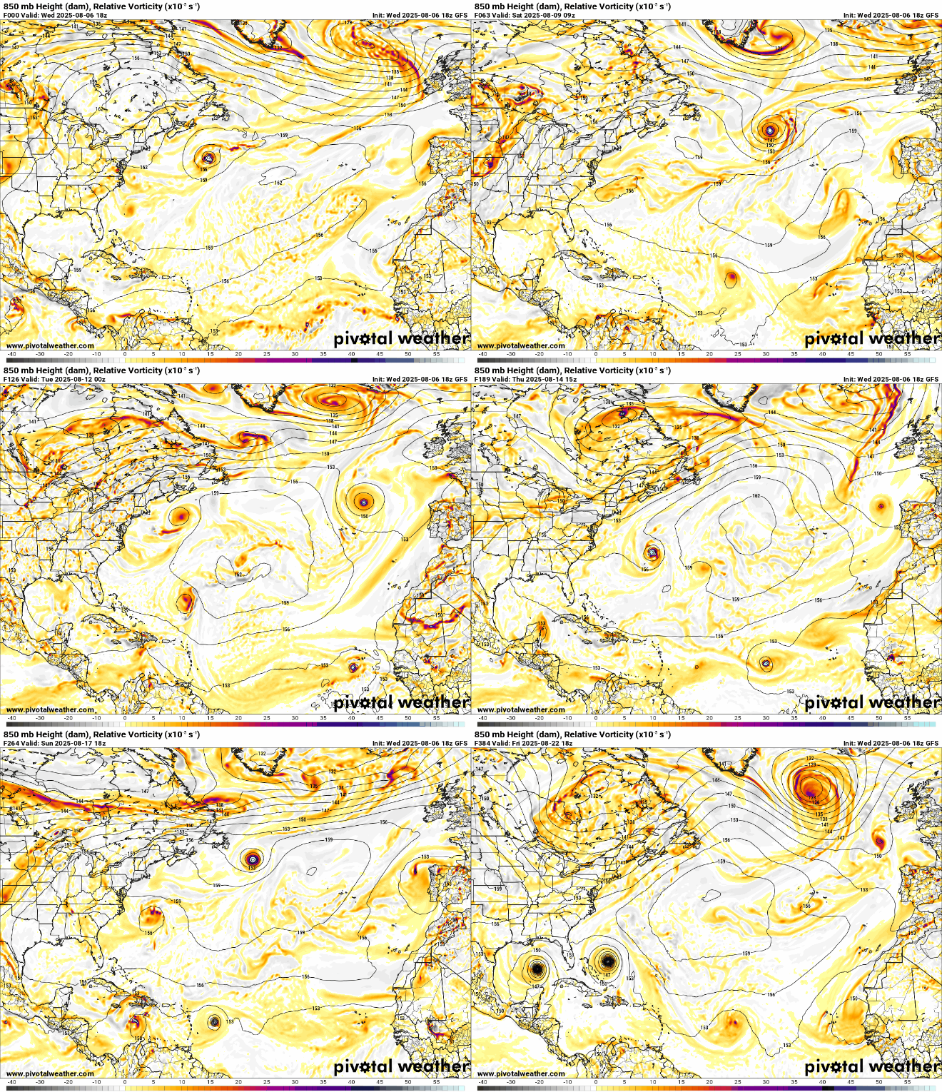
yeah 18z GFS has 7 maybe 8 different distinct areas coming and going by the end of the run. If even part of this verifies it's going to get confusing.

Image

Double vision happy hour at the end there.
3 likes   

User avatar
WaveBreaking
Category 2
Category 2
Posts: 589
Joined: Sun Jun 30, 2024 11:33 am
Location: US

Re: 2025 Global Model Runs Discussion (Out thru day 16)

#579 Postby WaveBreaking » Wed Aug 06, 2025 6:35 pm

Stratton23 wrote:Tropics really exploding on the 18z GFS lol, but that little wave near the leeward island is definitely getting my attention more


The twin Cat. 4 hurricanes at the end of the run definitely makes this run a top-15 top-10 happy hour run imo :lol: :lol: :lol:
Image
9 likes   

I am NOT a professional meteorologist, so take all of my posts with a grain of salt. My opinions are mine and mine alone.

zzzh
Category 3
Category 3
Posts: 853
Joined: Thu Sep 02, 2021 1:13 pm

Re: 2025 Global Model Runs Discussion (Out thru day 16)

#580 Postby zzzh » Wed Aug 06, 2025 7:04 pm

WaveBreaking wrote:
Stratton23 wrote:Tropics really exploding on the 18z GFS lol, but that little wave near the leeward island is definitely getting my attention more


The twin Cat. 4 hurricanes at the end of the run definitely makes this run a top-15 top-10 happy hour run imo :lol: :lol: :lol:
https://i.imgur.com/7o1obc7.png

Image
Looks familiar :lol: :lol: :lol:
5 likes   


Return to “Talkin' Tropics”

Who is online

Users browsing this forum: Cleveland Kent Evans, Cpv17, kevin, Pelicane and 50 guests