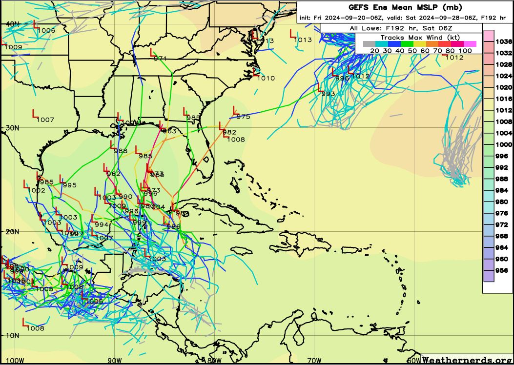
Low pressure developing over the western Caribbean Sea (Is Invest 97L)

This is the general tropical discussion area. Anyone can take their shot at predicting a storms path.

Moderator: S2k Moderators

Forum rules

The posts in this forum are NOT official forecasts and should not be used as such. They are just the opinion of the poster and may or may not be backed by sound meteorological data. They are NOT endorsed by any professional institution or STORM2K. For official information, please refer to products from the National Hurricane Center and National Weather Service.

Help Support Storm2K
Message
Author
User avatar
Category5Kaiju
Category 5
Category 5
Posts: 4097
Joined: Thu Dec 24, 2020 12:45 pm
Location: Seattle

Re: Area of low pressure to develop over the western Caribbean Sea

#541 Postby Category5Kaiju » Fri Sep 20, 2024 6:52 am

toad strangler wrote:
Blown Away wrote:[url]https://i.postimg.cc/vH8B0rSt/gfs-ememb-lowlocs-watl-fh126-240.gif [/url]

IMO, 06z GEFS are still in a big disagreement on timing. The FL W coast and Big Bend area members have this AOI landfalling in 7-8 days while NGOM have landfall in 9-10 day range. The faster developing AOI goes in @FL W coast and slower moving system goes to NGOM coast... The operational GFS keeps bouncing around on these timing scenarios, you can see the big timing difference between 18z vs 06z this morning... JMHO


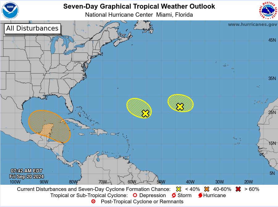
I hate to beat a dead horse, but that's because there is nothing there yet to really look at as far as a seedling disturbance. Models will naturally struggle with that, no?


We don't even have an Invest yet. I think things will become clearer once we get an Invest tagged and when the hurricane models jump into action.
5 likes   
Unless explicitly stated, all info in my posts is based on my own opinions and observations. Tropical storms and hurricanes can be extremely dangerous. Do not think you can beat Mother Nature. Refer to an accredited weather research agency or meteorologist if you need to make serious decisions regarding an approaching storm.

caneman
Category 5
Category 5
Posts: 1447
Joined: Fri Sep 05, 2014 5:44 am
Location: Clearwater Beach, Fl

Re: Area of low pressure to develop over the western Caribbean Sea

#542 Postby caneman » Fri Sep 20, 2024 6:59 am

I might be imagining things but it looks like there is some consolidation taking place in that area now. Let's see if it sustains.
0 likes   

User avatar
SouthFLTropics
Category 5
Category 5
Posts: 4236
Age: 50
Joined: Thu Aug 14, 2003 8:04 am
Location: Port St. Lucie, Florida

Re: Area of low pressure to develop over the western Caribbean Sea

#543 Postby SouthFLTropics » Fri Sep 20, 2024 7:02 am

We are going to have multiple solutions from all of the models including the ensembles until we actually have something to latch onto. Right now, they are spitting out different outcomes based on multiple unknown variables to provide a possible picture of what could happen. There are just too many unknowns at the moment for them to provide a definitive picture. To quote former defense secretary Rumsfeld, "there are unknown unknowns." With that said, I think we may already be seeing some early indications in real time of this thing coming together. The area off of the tip of the Honduras/Nicaragua border looks a little interesting this morning. When we get something more established, the model picture will come more into focus. Being in South Florida, a quick spin up of this system is not something we would want to see because I believe that we would be more at risk. A slower development will put the North Central to Northeastern gulf coast in play. Speed of development, strength, and timing. Right now, I'm on the lookout for any signs of quicker development.
1 likes   
Fourth Generation Florida Native

Personal Storm History: David 79, Andrew 92, Erin 95, Floyd 99, Irene 99, Frances 04, Jeanne 04, Wilma 05, Matthew 16, Irma 17, Ian 22, Nicole 22, Milton 24

Frank P
S2K Supporter
S2K Supporter
Posts: 2776
Joined: Fri Aug 29, 2003 10:52 am
Location: Biloxi Beach, Ms
Contact:

Re: Area of low pressure to develop over the western Caribbean Sea

#544 Postby Frank P » Fri Sep 20, 2024 7:08 am

The coffee might be starting to brew this morning... latest IR image loops
Image
9 likes   

User avatar
gatorcane
S2K Supporter
S2K Supporter
Posts: 23691
Age: 47
Joined: Sun Mar 13, 2005 3:54 pm
Location: Boca Raton, FL

Re: Area of low pressure to develop over the western Caribbean Sea

#545 Postby gatorcane » Fri Sep 20, 2024 7:33 am

Noticing the models are showing less of an ideal environment if the low develops and makes it into the GOM. The 00Z ECMWF has no development, partly because it keeps it over Central America but there does appear to be some shear in the GOM showing up in the models.

Image
Last edited by gatorcane on Fri Sep 20, 2024 7:34 am, edited 2 times in total.
0 likes   

User avatar
N2FSU
S2K Supporter
S2K Supporter
Posts: 1062
Joined: Thu Sep 04, 2003 2:04 pm
Location: Tallahassee, FL

Re: Area of low pressure to develop over the western Caribbean Sea

#546 Postby N2FSU » Fri Sep 20, 2024 7:34 am

WV looks quite interesting this morning
Image


Sent from my iPhone using Tapatalk
4 likes   

User avatar
StPeteMike
Category 2
Category 2
Posts: 631
Joined: Thu Jun 07, 2018 11:26 pm

Re: Area of low pressure to develop over the western Caribbean Sea

#547 Postby StPeteMike » Fri Sep 20, 2024 7:53 am

gatorcane wrote:Noticing the models are showing less of an ideal environment if the low develops and makes it into the GOM. The 00Z ECMWF has no development, partly because it keeps it over Central America but there does appear to be some shear in the GOM showing up in the models.

https://i.postimg.cc/SxX9tyb5/ecmwf-shear-watl-55.png

We shall see if this stays true.

This was from wxman 2 days out before future Michael got designated as a TD. And I respect wxman’s insights and professional expertise, but I still think we’re in a position that many struggle to forecast upper level conditions 5 days out. No fault on the mets or established posters here, just think that we have the technology to really analyze shear on a day to day basis across all of the CONJS and use the information provided to forecast shear conditions 5 days out.

wxman57 wrote:Note that current shear does not equal future shear. GFS indicates quite strong shear developing across the Gulf as the disturbance moves northward on Monday/Tuesday. I think we're looking at another sheared TS, similar to Gordon. Landfall somewhere between Pascagoula, MS and the mid FL Panhandle Wed afternoon. Went with 45 kts on my forecast. Certainly could not rule out 55-60 kts, but not forecasting that. Not much weather west of the track, and squalls could extend all the way east across the FL Peninsula Tue/Wed.

http://wxman57.com/images/shear.png
2 likes   
The above post is not official and should not be used as such. It is the opinion of the poster and may or may not be backed by sound meteorological data. It is not endorsed by any professional institution or storm2k.org. For official information, please refer to the NHC and NWS products.

User avatar
Blown Away
S2K Supporter
S2K Supporter
Posts: 10145
Joined: Wed May 26, 2004 6:17 am

Re: Area of low pressure to develop over the western Caribbean Sea

#548 Postby Blown Away » Fri Sep 20, 2024 7:55 am

Image
Image


The 8am NHC update bumped the potential area more into the BOC and the 06z GEFS have more weaker members into the Yucatan/BOC and fewer into the GOM. Wouldn't be shocked to see future GFS operational runs shift W into Yucatan/BOC. JMHO.
1 likes   
Hurricane Eye Experience: David 79, Irene 99, Frances 04, Jeanne 04, Wilma 05... EYE COMING MY WAY IN 2024…
Hurricane Brush Experience: Andrew 92, Erin 95, Floyd 99, Matthew 16, Irma 17, Ian 22, Nicole 22…

Ian2401
Category 1
Category 1
Posts: 307
Joined: Thu Sep 14, 2017 5:55 pm
Location: Tallahassee, Florida
Contact:

Re: Area of low pressure to develop over the western Caribbean Sea

#549 Postby Ian2401 » Fri Sep 20, 2024 7:58 am

convection east of honduras is interesting. models don't show any vorticity consolidation until early-mid next week. looking at the gfs simulated IR...nothing until that time frame either. nothing showing up on 850mb vort maps yet. even a little more concentrated vorticity in this area is something that can help jump start systems like this.

also seeing enhanced convection in the EPAC which IS forecast by the GFS.
1 likes   
B.S. Meteorology from Florida State '24 // Current M.S. Meteorology student at Florida State

Research Interests: Rapid Intensification, TC Climatology, TC Modeling

Consult the NHC for official information

User avatar
chaser1
S2K Supporter
S2K Supporter
Posts: 5464
Age: 64
Joined: Sat Oct 15, 2005 5:59 pm
Location: Longwood, Fl

Re: Area of low pressure to develop over the western Caribbean Sea

#550 Postby chaser1 » Fri Sep 20, 2024 8:13 am

gatorcane wrote:Noticing the models are showing less of an ideal environment if the low develops and makes it into the GOM. The 00Z ECMWF has no development, partly because it keeps it over Central America but there does appear to be some shear in the GOM showing up in the models.

https://i.postimg.cc/SxX9tyb5/ecmwf-shear-watl-55.png


Looks like orange duct tape protecting the Glass of Mexico, to me.
0 likes   
Andy D

(For official information, please refer to the NHC and NWS products.)

AutoPenalti
Category 5
Category 5
Posts: 4030
Age: 29
Joined: Mon Aug 17, 2015 4:16 pm
Location: Ft. Lauderdale, Florida

Re: Area of low pressure to develop over the western Caribbean Sea

#551 Postby AutoPenalti » Fri Sep 20, 2024 8:20 am

Less members pointing to Florida now, looks like a stall in the GOM is becoming increasingly more likely.
1 likes   
The posts in this forum are NOT official forecasts and should not be used as such. They are just the opinion of the poster and may or may not be backed by sound meteorological data. They are NOT endorsed by any professional institution or STORM2K. For official information, please refer to products from the NHC and NWS.


Model Runs Cheat Sheet:
GFS (5:30 AM/PM, 11:30 AM/PM)
HWRF, GFDL, UKMET, NAVGEM (6:30-8:00 AM/PM, 12:30-2:00 AM/PM)
ECMWF (1:45 AM/PM)

TCVN
is a weighted averaged

BobHarlem
Category 5
Category 5
Posts: 2108
Joined: Thu Oct 20, 2005 6:11 pm

Re: Area of low pressure to develop over the western Caribbean Sea

#552 Postby BobHarlem » Fri Sep 20, 2024 8:32 am

On the 6z GEFS nearly all members go to Florida... eventually. So there's a bunch of uncertainty here on the GFS ensembles.

Notable, nothing really develops until late Wednesday, which means storm2k will stay frosty for several days.
Quicker runs landfall on Friday, mid runs, monday, and stragglers a week from Wednesday.

If anyone says they know where this one is going and what will happen they are lying.

Image
2 likes   

psyclone
S2K Supporter
S2K Supporter
Posts: 4762
Joined: Wed Aug 24, 2005 9:04 pm
Location: palm harbor fl

Re: Area of low pressure to develop over the western Caribbean Sea

#553 Postby psyclone » Fri Sep 20, 2024 8:35 am

A sheared TS with some party squalls would be a delightful downgrade and certainly in the spirit of 2024 absurdly undershooting expectations. We'll take it as we impatiently await that cold front..
5 likes   

psyclone
S2K Supporter
S2K Supporter
Posts: 4762
Joined: Wed Aug 24, 2005 9:04 pm
Location: palm harbor fl

Re: Area of low pressure to develop over the western Caribbean Sea

#554 Postby psyclone » Fri Sep 20, 2024 8:39 am

The gulf is stupidly warm so any junk storm that can slay some of that surface warmth would lower the ceiling on potential late season chicanery. One can hope. We've already had 3 low end gulf cane landfalls...that seems like enough...
1 likes   

User avatar
ScottNAtlanta
Category 5
Category 5
Posts: 2367
Joined: Sat May 25, 2013 3:11 pm
Location: Atlanta, GA

Re: Area of low pressure to develop over the western Caribbean Sea

#555 Postby ScottNAtlanta » Fri Sep 20, 2024 8:39 am

Accuweather has some interesting graphics on historical tracks of systems that originate in this area this time of year. I was surprised by the percentage that made it to TX


Link: https://youtube.com/watch?v=Ro20qZGka-Y
1 likes   
The posts in this forum are NOT official forecast and should not be used as such. They are just the opinion of the poster and may or may not be backed by sound meteorological data. They are NOT endorsed by any professional institution or storm2k.org. For official information, please refer to the NHC and NWS products.

Stratton23
Category 5
Category 5
Posts: 2520
Joined: Fri Jul 21, 2023 10:59 pm
Location: Katy, Tx

Re: Area of low pressure to develop over the western Caribbean Sea

#556 Postby Stratton23 » Fri Sep 20, 2024 8:41 am

Problem is,a weak system wont upwell anything in the gulf, wont really cool off the water, i am thinking the models are over doing shear by a good bit, their will be shear, but not as much as what the GFS depicts, just have to wait and see where this disturbance begins to form
0 likes   

User avatar
Steve
S2K Supporter
S2K Supporter
Posts: 9621
Joined: Sat Apr 05, 2003 11:41 pm
Location: Not a state-caster

Re: Area of low pressure to develop over the western Caribbean Sea

#557 Postby Steve » Fri Sep 20, 2024 8:42 am

ThomasW wrote:Best analog here would be KAREN 2013 if these trends continue. Note the "if". However, the EPAC may receive TWO significant hurricanes instead, both of which could be threats to Mexico.


So it’s going to be annoying.
8 likes   

psyclone
S2K Supporter
S2K Supporter
Posts: 4762
Joined: Wed Aug 24, 2005 9:04 pm
Location: palm harbor fl

Re: Area of low pressure to develop over the western Caribbean Sea

#558 Postby psyclone » Fri Sep 20, 2024 8:47 am

Stratton23 wrote:Problem is,a weak system wont upwell anything in the gulf, wont really cool off the water, i am thinking the models are over doing shear by a good bit, their will be shear, but not as much as what the GFS depicts, just have to wait and see where this disturbance begins to form


Clouds, rain and wind will absolutely cool off the gulf from at a time that solar insulation is insufficient for recovery. It won't be cold but it will be less hot and McNoldy's OHC graphic which is sitting at record highs would drop substantially. The northern gulf is already cooling down but any wind and rain would grease those skids big time. We need a slop storm for that very reason. BTW the eastern gulf never did return to its pre Debby temps...and that one happened in early August.
0 likes   

WeatherBoy2000
Category 1
Category 1
Posts: 346
Joined: Mon Apr 10, 2023 9:29 am

Re: Area of low pressure to develop over the western Caribbean Sea

#559 Postby WeatherBoy2000 » Fri Sep 20, 2024 8:54 am

There's definitely still a lot of uncertainty which is being reflected by the gfs's highly volatile run to run fluctuations in intensity. The other global models aren't too hot on it, but many ensemble members still point to the potential of a powerful storm. I think it's too early to confidently say that this will be anything in either direction outside of a TC probably forming in or heading into the gulf in 5-7 days.
1 likes   

3090
Category 2
Category 2
Posts: 549
Age: 65
Joined: Fri Aug 19, 2011 4:01 pm

Re: Area of low pressure to develop over the western Caribbean Sea

#560 Postby 3090 » Fri Sep 20, 2024 9:09 am

Well here we are this morning diving into the why of the models showing little movement out of the southern GOM. So it went from the system is going across Fla, or the North central Gulf Coast to now where? It is still one big guess. Nothing changed from yesterday. Still a mystery.
0 likes   


Return to “Talkin' Tropics”

Who is online

Users browsing this forum: Google Adsense [Bot], KeysRedWine, lilbump3000, riapal, StormWeather, Stratton23, TomballEd and 48 guests