


2026 ENSO Updates
Moderator: S2k Moderators
Forum rules

The posts in this forum are NOT official forecasts and should not be used as such. They are just the opinion of the poster and may or may not be backed by sound meteorological data. They are NOT endorsed by any professional institution or STORM2K. For official information, please refer to products from the National Hurricane Center and National Weather Service.
Re: 2026 ENSO Updates
MJO forecasts is looping back to the Pacific, and may loop back yet again. 200mb CHI charts show sinking motion returning to the MC region while re-igniting over the Pacific. Pretty good indicator background low frequency is shifting closer to El Nino mode.
3 likes
The above post and any post by Ntxw is NOT an official forecast and should not be used as such. It is just the opinion of the poster and may or may not be backed by sound meteorological data. It is NOT endorsed by any professional institution including Storm2k. For official information, please refer to NWS products.
Help support Storm2K!
-
AJC3

- Admin

- Posts: 4156
- Age: 62
- Joined: Tue Aug 31, 2004 7:04 pm
- Location: Ballston Spa, New York
- Contact:
Re: 2026 ENSO Updates: Breaking News=BoM announces La Niña has ended
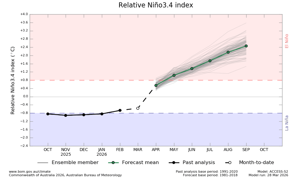
mixedDanilo.E wrote:cycloneye wrote:The first shoe has dropped and is from the BoM of Australia.
https://i.imgur.com/SNR3rQQ.jpeg
https://www.bom.gov.au/climate/ocean/outlooks/archive/20260328//plumes/sstOutlooks.rnino34.hr.png
https://www.bom.gov.au/climate/enso/?ni ... s=Overview
I'm not gonna lie to you, even though strong El Nino is looking more likely, I have a hard time believing we will get as as strong as the BoM forecasts, especially by September. What especially makes me want to partially throw this run out is a HUGE jump in the index from March to April. I'm sorry but I do not see that happening.
Since there's a dash between FEB-MAR, that makes me think that their MAR value (about -0.55C) is a hindcast/nowcast that was used to initialize that run of the ACCESS-S2, rather than an actual analyzed data point. That point on the graph doesn't even match their own NINO 3.4 value (-0.42C) shown in the text, and moreover, CPC's latest update from 30 MAR had that value as -0.3C. I know BoM/CPC have different ENSO thresholds, but is there also a fundamental difference in how actual ENSO values are calculated? In any event, if you plot the CPC value on the chart, then the BOM model change from MAR-APR doesn't look nearly as odd. Just some food for thought.

Caveat: There might be something I'm not taking into account about how the indices are calculated.
1 likes
-
DorkyMcDorkface

- Category 5

- Posts: 1037
- Age: 28
- Joined: Mon Sep 30, 2019 1:32 pm
- Location: Mid-Atlantic
Re: 2026 ENSO Updates
I've learned a lot about ENSO over the past 5 years but I have a question: when was the last time we've had a strong Niño event so suddenly after another? Seems like they occur once every decade or so, but this time around we're getting two in rather quick succession. I also wonder because the last time it was understandable with a triple-dip moderate Niña event the first half of the 2020s but this time around we've had two weaker Niña events (according to RONI, ONI was nearly merely cool-neutral for 2024-25). What's the case this time around?
0 likes
Please note the thoughts expressed by this account are solely those of the user and are from a hobbyist perspective. For more comprehensive analysis, consult an actual professional meteorologist or meteorological agency.
Floyd 1999 | Isabel 2003 | Hanna 2008 | Irene 2011 | Sandy 2012 | Isaias 2020
Re: 2026 ENSO Updates
DorkyMcDorkface wrote:I've learned a lot about ENSO over the past 5 years but I have a question: when was the last time we've had a strong Niño event so suddenly after another? Seems like they occur once every decade or so, but this time around we're getting two in rather quick succession. I also wonder because the last time it was understandable with a triple-dip moderate Niña event the first half of the 2020s but this time around we've had two weaker Niña events (according to RONI, ONI was nearly merely cool-neutral for 2024-25). What's the case this time around?
One aspect we have to think about is that the warm pool over the western Pacific has been prolific in the 2020s. The warm water expanse has been incredible El Nino or La Nina. 2023-2024 did not fully disperse this warm pool. It's physics, if the bathwater is continuously hot, any shift will allow it to move despite what ENSO was. This is something we don't fully understand with global oceans warming rapidly. A theoretical idea one could ask, since 2023-24 did not fully behave like a traditional Nino, could it be reason why we're seeing a more traditional one form so close?
1963-64, and then 1965-66 had a moderate and strong Nino pretty quickly.
6 likes
The above post and any post by Ntxw is NOT an official forecast and should not be used as such. It is just the opinion of the poster and may or may not be backed by sound meteorological data. It is NOT endorsed by any professional institution including Storm2k. For official information, please refer to NWS products.
Help support Storm2K!
Help support Storm2K!
-
cycloneye

- Admin
- Posts: 149666
- Age: 69
- Joined: Thu Oct 10, 2002 10:54 am
- Location: San Juan, Puerto Rico
Re: 2026 ENSO Updates
2 likes
Visit the Caribbean-Central America Weather Thread where you can find at first post web cams,radars
and observations from Caribbean basin members Click Here
and observations from Caribbean basin members Click Here
-
DorkyMcDorkface
- Category 5
- Posts: 1037
- Age: 28
- Joined: Mon Sep 30, 2019 1:32 pm
- Location: Mid-Atlantic
Re: 2026 ENSO Updates
Ntxw wrote:DorkyMcDorkface wrote:I've learned a lot about ENSO over the past 5 years but I have a question: when was the last time we've had a strong Niño event so suddenly after another? Seems like they occur once every decade or so, but this time around we're getting two in rather quick succession. I also wonder because the last time it was understandable with a triple-dip moderate Niña event the first half of the 2020s but this time around we've had two weaker Niña events (according to RONI, ONI was nearly merely cool-neutral for 2024-25). What's the case this time around?
One aspect we have to think about is that the warm pool over the western Pacific has been prolific in the 2020s. The warm water expanse has been incredible El Nino or La Nina. 2023-2024 did not fully disperse this warm pool. It's physics, if the bathwater is continuously hot, any shift will allow it to move despite what ENSO was. This is something we don't fully understand with global oceans warming rapidly. A theoretical idea one could ask, since 2023-24 did not fully behave like a traditional Nino, could it be reason why we're seeing a more traditional one form so close?
1963-64, and then 1965-66 had a moderate and strong Nino pretty quickly.
So would you say the accumulation of subsurface warmth in the Indo-Pacific Warm Pool is a byproduct of the three consecutive Niñas i mentioned + general warming of the oceans? I think the latter reason in particular could explain why a triple dip Niña event like 1998-2001 didn't result in a strong/super Niño in 2002-03 (was moderate and CPAC-based iirc). Perhaps if it occured nowadays in a warmer oceanic climate it might have?
1 likes
Please note the thoughts expressed by this account are solely those of the user and are from a hobbyist perspective. For more comprehensive analysis, consult an actual professional meteorologist or meteorological agency.
Floyd 1999 | Isabel 2003 | Hanna 2008 | Irene 2011 | Sandy 2012 | Isaias 2020
Re: 2026 ENSO Updates
DorkyMcDorkface wrote:Ntxw wrote:DorkyMcDorkface wrote:I've learned a lot about ENSO over the past 5 years but I have a question: when was the last time we've had a strong Niño event so suddenly after another? Seems like they occur once every decade or so, but this time around we're getting two in rather quick succession. I also wonder because the last time it was understandable with a triple-dip moderate Niña event the first half of the 2020s but this time around we've had two weaker Niña events (according to RONI, ONI was nearly merely cool-neutral for 2024-25). What's the case this time around?
One aspect we have to think about is that the warm pool over the western Pacific has been prolific in the 2020s. The warm water expanse has been incredible El Nino or La Nina. 2023-2024 did not fully disperse this warm pool. It's physics, if the bathwater is continuously hot, any shift will allow it to move despite what ENSO was. This is something we don't fully understand with global oceans warming rapidly. A theoretical idea one could ask, since 2023-24 did not fully behave like a traditional Nino, could it be reason why we're seeing a more traditional one form so close?
1963-64, and then 1965-66 had a moderate and strong Nino pretty quickly.
So would you say the accumulation of subsurface warmth in the Indo-Pacific Warm Pool is a byproduct of the three consecutive Niñas i mentioned + general warming of the oceans? I think the latter reason in particular could explain why a triple dip Niña event like 1998-2001 didn't result in a strong/super Niño in 2002-03 (was moderate and CPAC-based iirc). Perhaps if it occured nowadays in a warmer oceanic climate it might have?
Something of that nature would be a thought. 1997 super El Nino was also very efficient in dispersing the WPAC warm pool both oceanic and atmospherically whereas 2023 had trouble coupling at times. The warm pool back then was also less expansive than it is in recent times.
3 likes
The above post and any post by Ntxw is NOT an official forecast and should not be used as such. It is just the opinion of the poster and may or may not be backed by sound meteorological data. It is NOT endorsed by any professional institution including Storm2k. For official information, please refer to NWS products.
Help support Storm2K!
Help support Storm2K!
-
Kingarabian

- S2K Supporter

- Posts: 16376
- Joined: Sat Aug 08, 2009 3:06 am
- Location: Honolulu, Hawaii
Re: 2026 ENSO Updates
Twin cyclones should develop in the SWPAC over the next 48 hours. Their winds are showing on the 850mb wind anomaly hovmollers.
3 likes
RIP Kobe Bryant
-
USTropics
- Professional-Met

- Posts: 2739
- Joined: Sun Aug 12, 2007 3:45 am
- Location: Florida State University
Re: 2026 ENSO Updates
Ntxw wrote:DorkyMcDorkface wrote:Ntxw wrote:
One aspect we have to think about is that the warm pool over the western Pacific has been prolific in the 2020s. The warm water expanse has been incredible El Nino or La Nina. 2023-2024 did not fully disperse this warm pool. It's physics, if the bathwater is continuously hot, any shift will allow it to move despite what ENSO was. This is something we don't fully understand with global oceans warming rapidly. A theoretical idea one could ask, since 2023-24 did not fully behave like a traditional Nino, could it be reason why we're seeing a more traditional one form so close?
1963-64, and then 1965-66 had a moderate and strong Nino pretty quickly.
So would you say the accumulation of subsurface warmth in the Indo-Pacific Warm Pool is a byproduct of the three consecutive Niñas i mentioned + general warming of the oceans? I think the latter reason in particular could explain why a triple dip Niña event like 1998-2001 didn't result in a strong/super Niño in 2002-03 (was moderate and CPAC-based iirc). Perhaps if it occured nowadays in a warmer oceanic climate it might have?
Something of that nature would be a thought. 1997 super El Nino was also very efficient in dispersing the WPAC warm pool both oceanic and atmospherically whereas 2023 had trouble coupling at times. The warm pool back then was also less expansive than it is in recent times.
This is a really good point. We are seeing a potential rapid-succession El Nino even because the 2023-2024 'recharge-discharge' was interrupted/muted. Like some of our previous discussions a few months ago, the previous El Nino was atypically forced (the background state was overwhelmingly warm), and the discharge phase was incomplete. While the thermocline flattened to a degree, the full volume of upper-ocean heat content wasn't able to fully evacuate.
It would be interesting to see if there is relative research on anthropogenic heat and how that impacts the WPWB (my assumptions are it has made it deeper and more voluminous). This would require a much stronger and prolonged divergence mechanism (like the wind stress/WWB we are seeing for oceanic transport). The 2023-24 El Nino event was definitely not fully coupled. Specifically, the Walker Circulation was decoupled (i.e., unusual easterly wind anomalies) and the global oceans (particularly the Atlantic) were uniformly hot (hence the ENSO teleconnections were muted).
Due to the inconsistent ocean-atmospheric coupling, the discharge event was sluggish. Heat was shifted more towards the CPAC, but didn't fully leave the basin. The lingering residual heat (especially at the subsurface) is one of the reasons we could be seeing a significant El Nino on the horizon. This research article does a good job of highlighting how the integrated OHC from 0 to 2000 meters has significantly increased in the past ~45 years. Essentially, the warm pool has anomalously gained heat from the eastern boundary current faster than it loses it to the northern boundary current.
8 likes
-
Category5Kaiju

- Category 5
- Posts: 4345
- Joined: Thu Dec 24, 2020 12:45 pm
- Location: Seattle during the summer, Phoenix during the winter
Re: 2026 ENSO Updates
DorkyMcDorkface wrote:I've learned a lot about ENSO over the past 5 years but I have a question: when was the last time we've had a strong Niño event so suddenly after another? Seems like they occur once every decade or so, but this time around we're getting two in rather quick succession. I also wonder because the last time it was understandable with a triple-dip moderate Niña event the first half of the 2020s but this time around we've had two weaker Niña events (according to RONI, ONI was nearly merely cool-neutral for 2024-25). What's the case this time around?
Others have explained it fairly well, but yeah; at least since 1950, the only somewhat similar events would be 1994/1997 (Moderate and then Very Strong) or 1963/1965 (Moderate and then Strong). Two Strong/Very Strong El Nino events being separated by 3 years has never happened before in recorded times. With that being said, I think the 2023 El Nino was highly unorthodox despite its look as your textbook strong El Nino event given the background conditions and shoddy coupling that accompanied it. I mean, the WPAC that year featured below-average activity, which is something that shouldn't happen during a Strong El Nino event.
It's looking like this year is going to do what 2023 failed to do: a Strong El Nino event that actually has proper coupling and allows the WPAC and EPAC to go haywire. The way I see it, 2023 provided the blueprint instructions, and 2026 is reading those and executing it.
4 likes
Unless explicitly stated, all information in my posts is based on my own opinions and observations. Tropical storms and hurricanes can be extremely dangerous. Refer to an accredited weather research agency or meteorologist if you need to make serious decisions regarding an approaching storm.
-
DorkyMcDorkface
- Category 5
- Posts: 1037
- Age: 28
- Joined: Mon Sep 30, 2019 1:32 pm
- Location: Mid-Atlantic
Re: 2026 ENSO Updates
I appreciate the input from everyone, it's starting to make more sense now. 2023-24 was definitely unorthodox as far as strong Niños go given the lack of true atmospheric response and competition from other parts of the globe (definitive -PDO and -PMM likely didn't help). And yes, it was very much evident by high NATL activity and unusually low WPAC activity (EPAC behaved more like you'd expect interestingly enough). Everything was kind of "off" that year, but things so far are behaving more typical of an imminent upper-echelon Niño event this year.
2 likes
Please note the thoughts expressed by this account are solely those of the user and are from a hobbyist perspective. For more comprehensive analysis, consult an actual professional meteorologist or meteorological agency.
Floyd 1999 | Isabel 2003 | Hanna 2008 | Irene 2011 | Sandy 2012 | Isaias 2020
-
dexterlabio
- Category 5
- Posts: 3517
- Joined: Sat Oct 24, 2009 11:50 pm
Re: 2026 ENSO Updates
^Just to float it out there that the WPAC season being seemingly inactive in 2023 is due to the record low number of tropical storms that developed that year. However, WPAC boasted an above average ACE that year.
This is not to discount the fact that 2023 was a very unusual year for a strong El Niño, but little details like the ACE must also be taken into account if we want to get the complete picture as to what went "different."
This is not to discount the fact that 2023 was a very unusual year for a strong El Niño, but little details like the ACE must also be taken into account if we want to get the complete picture as to what went "different."
2 likes
Personal Forecast Disclaimer:
The posts in this forum are NOT official forecast and should not be used as such. They are just the opinion of the poster and may or may not be backed by sound meteorological data. They are NOT endorsed by any professional institution or storm2k.org. For official information, please refer to the NHC and NWS products.
The posts in this forum are NOT official forecast and should not be used as such. They are just the opinion of the poster and may or may not be backed by sound meteorological data. They are NOT endorsed by any professional institution or storm2k.org. For official information, please refer to the NHC and NWS products.
-
Kingarabian
- S2K Supporter
- Posts: 16376
- Joined: Sat Aug 08, 2009 3:06 am
- Location: Honolulu, Hawaii
Re: 2026 ENSO Updates
A strong MJO pulse is finally in the forecast for the Pacific even though its late. SWPAC and CPAC basins carrying most of the weight and will be a fountain for tropical and sub tropical disturbances.
We'll see this in real time over the next 16 days with repeat candidates for TCG stretching from 15N to 15S and should all be reflected in the MJO and 850mb wind charts. Should also be an uptick in WPAC activity.
We'll see this in real time over the next 16 days with repeat candidates for TCG stretching from 15N to 15S and should all be reflected in the MJO and 850mb wind charts. Should also be an uptick in WPAC activity.
1 likes
RIP Kobe Bryant
-
DorkyMcDorkface
- Category 5
- Posts: 1037
- Age: 28
- Joined: Mon Sep 30, 2019 1:32 pm
- Location: Mid-Atlantic
Re: 2026 ENSO Updates
Kingarabian wrote:A strong MJO pulse is finally in the forecast for the Pacific even though its late. SWPAC and CPAC basins carrying most of the weight and will be a fountain for tropical and sub tropical disturbances.
We'll see this in real time over the next 16 days with repeat candidates for TCG stretching from 15N to 15S and should all be reflected in the MJO and 850mb wind charts. Should also be an uptick in WPAC activity.
Pacific MJO signal has definitely become well-defined on the GEFS RMM plot. Normally you could chalk this up to being a result of its amplification bias but in this case it can be inferred it's a legitimate signal given the powerful WWB spawning TC activity on both sides of the equator.

2 likes
Please note the thoughts expressed by this account are solely those of the user and are from a hobbyist perspective. For more comprehensive analysis, consult an actual professional meteorologist or meteorological agency.
Floyd 1999 | Isabel 2003 | Hanna 2008 | Irene 2011 | Sandy 2012 | Isaias 2020
-
Yellow Evan

- Professional-Met
- Posts: 16255
- Age: 27
- Joined: Fri Jul 15, 2011 12:48 pm
- Location: Henderson, Nevada/Honolulu, HI
- Contact:
Re: 2026 ENSO Updates
dexterlabio wrote:^Just to float it out there that the WPAC season being seemingly inactive in 2023 is due to the record low number of tropical storms that developed that year. However, WPAC boasted an above average ACE that year.
This is not to discount the fact that 2023 was a very unusual year for a strong El Niño, but little details like the ACE must also be taken into account if we want to get the complete picture as to what went "different."
Unorthodox coupled El Niños produce unorthodox outcomes. 1969 was similar to 2023 in terms of quality but not quantity and unusual Atlantic activity. On the other hand of the spectrum, 1977 and 2004 were Modokis struggled hard in the East Pacific with two very different outcomes in the Atlantic.
Last edited by Yellow Evan on Tue Apr 07, 2026 9:51 pm, edited 1 time in total.
2 likes
Re: 2026 ENSO Updates
dexterlabio wrote:^Just to float it out there that the WPAC season being seemingly inactive in 2023 is due to the record low number of tropical storms that developed that year. However, WPAC boasted an above average ACE that year.
This is not to discount the fact that 2023 was a very unusual year for a strong El Niño, but little details like the ACE must also be taken into account if we want to get the complete picture as to what went "different."
2023 typhoon season had about 270 ace, which is below average
1 likes
-
xtyphooncyclonex

- Category 5
- Posts: 3897
- Age: 24
- Joined: Sat Dec 08, 2012 9:07 am
- Location: Cebu City
- Contact:
Re: 2026 ENSO Updates
zzzh wrote:dexterlabio wrote:^Just to float it out there that the WPAC season being seemingly inactive in 2023 is due to the record low number of tropical storms that developed that year. However, WPAC boasted an above average ACE that year.
This is not to discount the fact that 2023 was a very unusual year for a strong El Niño, but little details like the ACE must also be taken into account if we want to get the complete picture as to what went "different."
2023 typhoon season had about 270 ace, which is below average
I think the point he was trying to make was that it was an unusual quality over quantity year, at the expense of quantity. Wiki says it's above the average, though it's debatable since diff sources have the average at around 290-300.
ACE per storm was typical for an El Niño year = above 16. It also has the highest ACE of any WPac season in the 2020s. There must have been something suppressing convective activity but keeping storms intense for long if they formed.
2 likes
REMINDER: My opinions that I, or any other NON Pro-Met in this forum, are unofficial. Please do not take my opinions as an official forecast and warning. I am NOT a meteorologist. Following my forecasts blindly may lead to false alarm, danger and risk if official forecasts from agencies are ignored.
-
dexterlabio
- Category 5
- Posts: 3517
- Joined: Sat Oct 24, 2009 11:50 pm
Re: 2026 ENSO Updates
zzzh wrote:dexterlabio wrote:^Just to float it out there that the WPAC season being seemingly inactive in 2023 is due to the record low number of tropical storms that developed that year. However, WPAC boasted an above average ACE that year.
This is not to discount the fact that 2023 was a very unusual year for a strong El Niño, but little details like the ACE must also be taken into account if we want to get the complete picture as to what went "different."
2023 typhoon season had about 270 ace, which is below average
There are different metric perhaps as to what counts as normal or above normal in terms of ACE. Using the 1991 to 2010 dataset, 301 is considered the average for the WPAC.
Nonetheless, 2023 still had a very high ACE per TC for the WPAC, which I think should be considered if we are to analyze what went different that year. Because if we are only going to base on the TC count, we might draw conclusions that are not quite accurate.
2 likes
Personal Forecast Disclaimer:
The posts in this forum are NOT official forecast and should not be used as such. They are just the opinion of the poster and may or may not be backed by sound meteorological data. They are NOT endorsed by any professional institution or storm2k.org. For official information, please refer to the NHC and NWS products.
The posts in this forum are NOT official forecast and should not be used as such. They are just the opinion of the poster and may or may not be backed by sound meteorological data. They are NOT endorsed by any professional institution or storm2k.org. For official information, please refer to the NHC and NWS products.
-
cycloneye
- Admin
- Posts: 149666
- Age: 69
- Joined: Thu Oct 10, 2002 10:54 am
- Location: San Juan, Puerto Rico
Re: 2026 ENSO Updates
The mother of WWB's is coming.

1 likes
Visit the Caribbean-Central America Weather Thread where you can find at first post web cams,radars
and observations from Caribbean basin members Click Here
and observations from Caribbean basin members Click Here
-
Kingarabian
- S2K Supporter
- Posts: 16376
- Joined: Sat Aug 08, 2009 3:06 am
- Location: Honolulu, Hawaii
Re: 2026 ENSO Updates
2026-02 -0.2696 PDO
JMA had the PDO warming up to -0.26 the warmest in nearly 6 years by their measures.
JMA had the PDO warming up to -0.26 the warmest in nearly 6 years by their measures.
1 likes
RIP Kobe Bryant
Who is online
Users browsing this forum: Hurricane2022, Iceresistance, WaveBreaking and 196 guests