2012 Tropical Waves
Moderator: S2k Moderators
Forum rules

The posts in this forum are NOT official forecasts and should not be used as such. They are just the opinion of the poster and may or may not be backed by sound meteorological data. They are NOT endorsed by any professional institution or STORM2K. For official information, please refer to products from the National Hurricane Center and National Weather Service.
-
cycloneye

- Admin

- Posts: 149769
- Age: 69
- Joined: Thu Oct 10, 2002 10:54 am
- Location: San Juan, Puerto Rico
Re: First 2012 Atlantic Tropical Wave on 5/16/12 at 18z
TROPICAL WEATHER DISCUSSION
NWS NATIONAL HURRICANE CENTER MIAMI FL
805 AM EDT FRI MAY 25 2012
...TROPICAL WAVES...
A CARIBBEAN SEA TROPICAL WAVE IS ALONG 14N61W 12N63W 8N63W IN
NORTHEASTERN VENEZUELA. WIDELY SCATTERED TO SCATTERED MODERATE
AND ISOLATED STRONG CONVECTIVE PRECIPITATION IS 16N BETWEEN
58W AND 70W.
0 likes
Visit the Caribbean-Central America Weather Thread where you can find at first post web cams,radars
and observations from Caribbean basin members Click Here
and observations from Caribbean basin members Click Here
-
cycloneye
- Admin
- Posts: 149769
- Age: 69
- Joined: Thu Oct 10, 2002 10:54 am
- Location: San Juan, Puerto Rico
Re: First 2012 Atlantic Tropical Wave on 5/16/12 at 18z
TROPICAL WEATHER DISCUSSION
NWS NATIONAL HURRICANE CENTER MIAMI FL
205 PM EDT FRI MAY 25 2012
...TROPICAL WAVES...
TROPICAL WAVE EXTENDS FROM 15N63W TO 10N65W MOVING W THROUGH THE
SE CARIBBEAN AT 15-20 KT. THE WAVE LIES ON THE ERN SIDE OF AN
AREA OF DEEP MOISTURE PRESENT IN TOTAL PRECIPITABLE WATER
IMAGERY. A SMALL AREA OF SCATTERED MODERATE CONVECTION IS FROM
13N-15N BETWEEN 65W-67W.
0 likes
Visit the Caribbean-Central America Weather Thread where you can find at first post web cams,radars
and observations from Caribbean basin members Click Here
and observations from Caribbean basin members Click Here
-
cycloneye
- Admin
- Posts: 149769
- Age: 69
- Joined: Thu Oct 10, 2002 10:54 am
- Location: San Juan, Puerto Rico
Re: First two waves introduced on 5/16/12 at 18z/2nd still alive
TROPICAL WEATHER DISCUSSION
NWS NATIONAL HURRICANE CENTER MIAMI FL
805 PM EDT FRI MAY 25 2012
TROPICAL WAVE EXTENDS OVER THE E CARIBBEAN FROM 15N64W TO 10N65W
MOVING W AT 15-20 KT. THE WAVE LIES ON THE ERN SIDE OF AN AREA
OF DEEP MOISTURE PRESENT IN TOTAL PRECIPITABLE WATER IMAGERY.
SCATTERED SHOWERS ARE FROM 12N-16N BETWEEN 61W-70W
0 likes
Visit the Caribbean-Central America Weather Thread where you can find at first post web cams,radars
and observations from Caribbean basin members Click Here
and observations from Caribbean basin members Click Here
-
cycloneye
- Admin
- Posts: 149769
- Age: 69
- Joined: Thu Oct 10, 2002 10:54 am
- Location: San Juan, Puerto Rico
Re: First two waves introduced on 5/16/12 at 18z/2nd still alive
TROPICAL WEATHER DISCUSSION
NWS NATIONAL HURRICANE CENTER MIAMI FL
205 AM EDT FRI MAY 25 2012
...TROPICAL WAVES...
A CARIBBEAN SEA TROPICAL WAVE IS ALONG 16N66W 13N63W 9N68W IN
NORTH CENTRAL VENEZUELA. RAINSHOWERS ARE POSSIBLE TO THE SOUTH
OF 17N BETWEEN 60W AND 71W.
NWS NATIONAL HURRICANE CENTER MIAMI FL
205 AM EDT FRI MAY 25 2012
...TROPICAL WAVES...
A CARIBBEAN SEA TROPICAL WAVE IS ALONG 16N66W 13N63W 9N68W IN
NORTH CENTRAL VENEZUELA. RAINSHOWERS ARE POSSIBLE TO THE SOUTH
OF 17N BETWEEN 60W AND 71W.
0 likes
Visit the Caribbean-Central America Weather Thread where you can find at first post web cams,radars
and observations from Caribbean basin members Click Here
and observations from Caribbean basin members Click Here
-
cycloneye
- Admin
- Posts: 149769
- Age: 69
- Joined: Thu Oct 10, 2002 10:54 am
- Location: San Juan, Puerto Rico
Re: First two waves introduced on 5/16/12 at 18z/2nd still alive
TROPICAL WEATHER DISCUSSION
NWS NATIONAL HURRICANE CENTER MIAMI FL
805 AM EDT SAT MAY 26 2012
...TROPICAL WAVES...
A CARIBBEAN SEA TROPICAL WAVE IS ALONG 16N66W...TO CURACAO...
TO 10N70W IN NORTHWESTERN VENEZUELA. NUMEROUS STRONG CONVECTIVE
PRECIPITATION IS ON TOP OF LAKE MARACAIBO IN NORTHWESTERN
VENEZUELA...AND JUST TO THE EAST OF THE LAKE WITHIN A 30 NM
RADIUS OF 9N69W. RAINSHOWERS ARE POSSIBLE IN THE CARIBBEAN SEA
TO THE SOUTH OF 17N BETWEEN 60W AND 72W.
0 likes
Visit the Caribbean-Central America Weather Thread where you can find at first post web cams,radars
and observations from Caribbean basin members Click Here
and observations from Caribbean basin members Click Here
-
cycloneye
- Admin
- Posts: 149769
- Age: 69
- Joined: Thu Oct 10, 2002 10:54 am
- Location: San Juan, Puerto Rico
Re: First two waves introduced on 5/16/12 at 18z/2nd still alive
TROPICAL WEATHER DISCUSSION
NWS NATIONAL HURRICANE CENTER MIAMI FL
205 PM EDT SAT MAY 26 2012
...TROPICAL WAVES...
A CARIBBEAN SEA TROPICAL WAVE IS ALONG 16571W ACROSS THE GUAJIRA
PENINSULA IN NE COLOMBIA INTO WESTERN VENEZUELA NEAR LAKE
MARACAIBO. WIND DATA FROM BUOY AND LAND BASED OBSERVATIONS
INDICATE THE WAVE IS VERY BROAD...BUT STACKS WELL WITH CYCLONIC
TURNING NOTED IN LOW LEVEL SATELLITE DERIVED WIND DISPLAYS.
CONVECTION REMAINS MINIMAL DESPITE DECENT PRECIPITABLE WATER
VALUES IN THE S CENTRAL CARIBBEAN NOTED ON SATELLITE AND
REGIONAL SOUNDING DATA. THE MAIN IMPACT OF THE WAVE SO FAR ON
SENSIBLE WEATHER IS TO ENHANCE TRADE WIND FLOW SLIGHTLY...AS FAR
N AS THE N SIDE OF HISPANIOLA WHERE 20 KT WINDS ARE NOTED IN
SHIP AND SCATTEROMETER DATA. CONVECTION WILL LIKELY INCREASE
SLIGHTLY AS THE WAVE SHIFTS WESTWARD INTO THE SW CARIBBEAN
THROUGH MON...AND INTERACTS WITH A QUASI-STATIONARY UPPER TROUGH
EXTENDING OVER THE NW CARIBBEAN. THE WAVE WILL LOSE ITS DISTINCT
IDENTITY THROUGH SUN AS IT INTERACTS WITH THE UPPER TROUGH...AND
STALLS OVER THE FAR SW CARIBBEAN.
0 likes
Visit the Caribbean-Central America Weather Thread where you can find at first post web cams,radars
and observations from Caribbean basin members Click Here
and observations from Caribbean basin members Click Here
-
cycloneye
- Admin
- Posts: 149769
- Age: 69
- Joined: Thu Oct 10, 2002 10:54 am
- Location: San Juan, Puerto Rico
Re: First two waves introduced on 5/16/12 at 18z/2nd still alive
TROPICAL WEATHER DISCUSSION
NWS NATIONAL HURRICANE CENTER MIAMI FL
805 PM EDT SAT MAY 26 2012
...TROPICAL WAVES...
A CARIBBEAN SEA TROPICAL WAVE IS ALONG 74W S OF 17N MOVING W AT
20-25 KT. CYCLONIC TURING IS NOTED IN LOW LEVEL SATELLITE
DERIVED WIND DISPLAYS. CONVECTION REMAINS MINIMAL DESPITE DECENT
PRECIPITABLE WATER VALUES IN THE S CENTRAL CARIBBEAN NOTED ON
SATELLITE AND REGIONAL SOUNDING DATA.
0 likes
Visit the Caribbean-Central America Weather Thread where you can find at first post web cams,radars
and observations from Caribbean basin members Click Here
and observations from Caribbean basin members Click Here

-
cycloneye
- Admin
- Posts: 149769
- Age: 69
- Joined: Thu Oct 10, 2002 10:54 am
- Location: San Juan, Puerto Rico
Re: First two waves introduced on 5/16/12 at 18z/2nd still alive
TROPICAL WEATHER DISCUSSION
NWS NATIONAL HURRICANE CENTER MIAMI FL
205 AM EDT SUN MAY 27 2012
...TROPICAL WAVES...
A CARIBBEAN SEA TROPICAL WAVE IS ALONG 74W/75W TO THE SOUTH OF
17N. THIS WAVE IS BECOMING DIFFUSE AND WEAKENING. IT IS MOST
PROBABLE THAT THIS FEATURE WILL BE DROPPED FROM THE 27/0600 UTC
SURFACE MAP ANALYSIS.
NWS NATIONAL HURRICANE CENTER MIAMI FL
205 AM EDT SUN MAY 27 2012
...TROPICAL WAVES...
A CARIBBEAN SEA TROPICAL WAVE IS ALONG 74W/75W TO THE SOUTH OF
17N. THIS WAVE IS BECOMING DIFFUSE AND WEAKENING. IT IS MOST
PROBABLE THAT THIS FEATURE WILL BE DROPPED FROM THE 27/0600 UTC
SURFACE MAP ANALYSIS.
0 likes
Visit the Caribbean-Central America Weather Thread where you can find at first post web cams,radars
and observations from Caribbean basin members Click Here
and observations from Caribbean basin members Click Here
-
cycloneye
- Admin
- Posts: 149769
- Age: 69
- Joined: Thu Oct 10, 2002 10:54 am
- Location: San Juan, Puerto Rico
Re: First two waves introduced on 5/16/12 at 18z/2nd still alive
It was dropped from analysis.
TROPICAL WEATHER DISCUSSION
NWS NATIONAL HURRICANE CENTER MIAMI FL
805 AM EDT SUN MAY 27 2012
...TROPICAL WAVES...
THE 74W/75W TROPICAL WAVE DISSIPATED AND IT WAS DROPPED FROM
THE 27/0600 UTC SURFACE MAP ANALYSIS.
TROPICAL WEATHER DISCUSSION
NWS NATIONAL HURRICANE CENTER MIAMI FL
805 AM EDT SUN MAY 27 2012
...TROPICAL WAVES...
THE 74W/75W TROPICAL WAVE DISSIPATED AND IT WAS DROPPED FROM
THE 27/0600 UTC SURFACE MAP ANALYSIS.
0 likes
Visit the Caribbean-Central America Weather Thread where you can find at first post web cams,radars
and observations from Caribbean basin members Click Here
and observations from Caribbean basin members Click Here

Re: First 2 waves on 5/16/12 at 18z/2nd gone at 5/27/12 at 06z
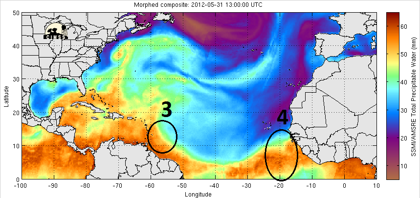
Tropical Wave #4
Introduced: 1200 UTC 31 May 2012
Introduced: 1200 UTC 31 May 2012
0 likes
Re: 2012 Tropical Waves
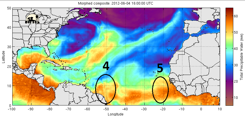
Nice looking wave at 10N/35W for this time of year. Getting that inverted V look. Even a sign of some broad turning.
0 likes


Re: First 2 waves on 5/16/12 at 18z/2nd gone at 5/27/12 at 06z
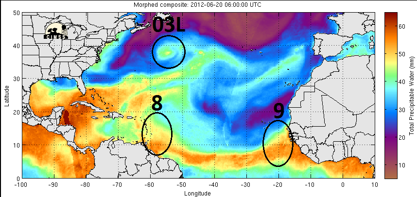
Tropical Wave #10
Introduced: 0600 UTC 24 June 2012
Related thread: http://www.storm2k.org/phpbb2/viewtopic.php?f=31&t=113053
Invest thread: http://www.storm2k.org/phpbb2/viewtopic.php?f=59&t=113074 (97L)

Introduced: 0600 UTC 24 June 2012
Related thread: http://www.storm2k.org/phpbb2/viewtopic.php?f=31&t=113053
Invest thread: http://www.storm2k.org/phpbb2/viewtopic.php?f=59&t=113074 (97L)
0 likes
Re: 2012 Tropical Waves

Anyone know why that area near 30W isn't a wave? Sure looks like on on TPW.
0 likes
-
Aric Dunn
- Category 5

- Posts: 21238
- Age: 43
- Joined: Sun Sep 19, 2004 9:58 pm
- Location: Ready for the Chase.
- Contact:
holy impressive wave that just came off affrica.
0 likes
Note: If I make a post that is brief. Please refer back to previous posts for the analysis or reasoning. I do not re-write/qoute what my initial post said each time.
If there is nothing before... then just ask
Space & Atmospheric Physicist, Embry-Riddle Aeronautical University,
I believe the sky is falling...
If there is nothing before... then just ask
Space & Atmospheric Physicist, Embry-Riddle Aeronautical University,
I believe the sky is falling...
Who is online
Users browsing this forum: cycloneye, hurricanes1234 and 152 guests