
Latest GFS is painting the same picture as it happened with 94L.
As this tropical wave that is entering the eastern Caribbean reaches the central and western Caribbean it will be interacting with yet another UL trough in the eastern GOM/western Carib and as another system gets going in the eastern Pacific. This tropical wave looks like it will get the Caribbean disturbed once again but it may not get a chance for best development until it reaches extreme western Caribbean or BOC, if at all.
2011 Tropical Waves
Moderator: S2k Moderators
Forum rules

The posts in this forum are NOT official forecasts and should not be used as such. They are just the opinion of the poster and may or may not be backed by sound meteorological data. They are NOT endorsed by any professional institution or STORM2K. For official information, please refer to products from the National Hurricane Center and National Weather Service.

Re: 2011 Tropical Waves
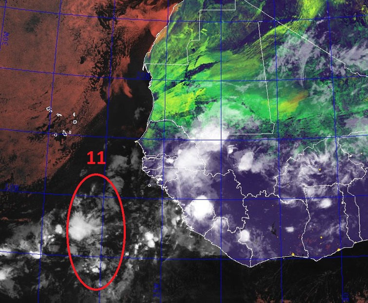
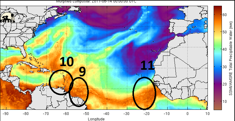
cycloneye wrote:Wave #11 Introduced on 6/14/11 at 00z around 20W
Uploaded by imageshack.us

Sorry, forgot to do this one.

0 likes
-
cycloneye

- Admin

- Posts: 149777
- Age: 69
- Joined: Thu Oct 10, 2002 10:54 am
- Location: San Juan, Puerto Rico
Re: 2011 Tropical Waves
Wave #12 Introduced on 6/17/11 at 18z Around 20W

Uploaded by imageshack.us
Uploaded by imageshack.us
0 likes
Visit the Caribbean-Central America Weather Thread where you can find at first post web cams,radars
and observations from Caribbean basin members Click Here
and observations from Caribbean basin members Click Here
-
cycloneye
- Admin
- Posts: 149777
- Age: 69
- Joined: Thu Oct 10, 2002 10:54 am
- Location: San Juan, Puerto Rico
Re: 2011 Tropical Waves
Wave # 13 Introduced at 6/21/11 on 18z around 17W
This wave is the most northward in latitud that has been introduced so far this year.IMO,in part, the cooling of the Gulf of Guinea factor is starting to have effects in that part of the world with the moonson trough way up in latitud.

Uploaded by imageshack.us
This wave is the most northward in latitud that has been introduced so far this year.IMO,in part, the cooling of the Gulf of Guinea factor is starting to have effects in that part of the world with the moonson trough way up in latitud.
Uploaded by imageshack.us
0 likes
Visit the Caribbean-Central America Weather Thread where you can find at first post web cams,radars
and observations from Caribbean basin members Click Here
and observations from Caribbean basin members Click Here
-
cycloneye
- Admin
- Posts: 149777
- Age: 69
- Joined: Thu Oct 10, 2002 10:54 am
- Location: San Juan, Puerto Rico
Re: 2011 Tropical Waves
Wave #14 Introduced at 6/25/11 on 06z around 27W

Uploaded by imageshack.us
Uploaded by imageshack.us
0 likes
Visit the Caribbean-Central America Weather Thread where you can find at first post web cams,radars
and observations from Caribbean basin members Click Here
and observations from Caribbean basin members Click Here
-
cycloneye
- Admin
- Posts: 149777
- Age: 69
- Joined: Thu Oct 10, 2002 10:54 am
- Location: San Juan, Puerto Rico
Re: 2011 Tropical Waves
Wave #15 Introduced at 7/1/11 on 18z around 20W

Uploaded by imageshack.us
Uploaded by imageshack.us
0 likes
Visit the Caribbean-Central America Weather Thread where you can find at first post web cams,radars
and observations from Caribbean basin members Click Here
and observations from Caribbean basin members Click Here

Re: 2011 Tropical Waves
So far some of them have been pretty impressive, and though I mentioned a slow start to things (until Arlene), my thoughts over the past couple of months is that this season might be more of a problem than the past 3 or 4...
Frank
Frank
0 likes
-
cycloneye
- Admin
- Posts: 149777
- Age: 69
- Joined: Thu Oct 10, 2002 10:54 am
- Location: San Juan, Puerto Rico
Re: 2011 Tropical Waves
Wave #16 Introduced at 12z on 7/6/11
A TROPICAL WAVE WAS FOUND THIS MORNING...EMBEDDED IN THE ITCZ
WITH AXIS ANALYZED FROM 11N39W TO 4N42W MOVING W AT ABOUT 12 KT.
A DEEP LAYER MOISTURE SURROUNDS THIS WAVE ON TOTAL PRECIPITABLE
WATER IMAGERY. THE AREA OF CONVECTION ASSOCIATED TO THE WAVE IS
EMBEDDED IN THE ITCZ DISCUSSED BELOW.
A TROPICAL WAVE WAS FOUND THIS MORNING...EMBEDDED IN THE ITCZ
WITH AXIS ANALYZED FROM 11N39W TO 4N42W MOVING W AT ABOUT 12 KT.
A DEEP LAYER MOISTURE SURROUNDS THIS WAVE ON TOTAL PRECIPITABLE
WATER IMAGERY. THE AREA OF CONVECTION ASSOCIATED TO THE WAVE IS
EMBEDDED IN THE ITCZ DISCUSSED BELOW.
0 likes
Visit the Caribbean-Central America Weather Thread where you can find at first post web cams,radars
and observations from Caribbean basin members Click Here
and observations from Caribbean basin members Click Here
-
cycloneye
- Admin
- Posts: 149777
- Age: 69
- Joined: Thu Oct 10, 2002 10:54 am
- Location: San Juan, Puerto Rico
Re: 2011 Tropical Waves
Wave #17 Introduced at 18z on 7/7/11 around 25W

Uploaded by imageshack.us
Uploaded by imageshack.us
0 likes
Visit the Caribbean-Central America Weather Thread where you can find at first post web cams,radars
and observations from Caribbean basin members Click Here
and observations from Caribbean basin members Click Here

Re: 2011 Tropical Waves
I didnt know where to post it so I'm going to try it here. I see in the Central and Eastern Atlantic loop what looks like a large wave @ 20 N 39 W. I don't see introduced as a wave but sure looks like 1 to me.
Looks like it will travel SW or WSW for a day or 2 taking it into a moister atmosphere with warmer waters and father away from that UUL. It's in the desert of the Central Atlantic right now but in a couple of day if it holds together could be something to watch. We'll see I'm just a little bored.

Looks like it will travel SW or WSW for a day or 2 taking it into a moister atmosphere with warmer waters and father away from that UUL. It's in the desert of the Central Atlantic right now but in a couple of day if it holds together could be something to watch. We'll see I'm just a little bored.
0 likes
The following post is NOT an official forecast and should not be used as such. It is just the opinion of the poster and may or may not be backed by sound meteorological data. It is NOT endorsed by any professional institution including storm2k.org For Official Information please refer to the NHC and NWS products.
-
cycloneye
- Admin
- Posts: 149777
- Age: 69
- Joined: Thu Oct 10, 2002 10:54 am
- Location: San Juan, Puerto Rico
Re: 2011 Tropical Waves
Wave #18 introduced at 06z on 7/12/11 around 25W

Uploaded by imageshack.us
Uploaded by imageshack.us
0 likes
Visit the Caribbean-Central America Weather Thread where you can find at first post web cams,radars
and observations from Caribbean basin members Click Here
and observations from Caribbean basin members Click Here

Re: 2011 Tropical Waves
Dust Storm Shrouds Algeria And Mali
A dust storm blew through parts of Algeria and Mali on Sunday and Monday. The storm was so large that parts the north African nations were hidden when the Moderate Resolution Imaging Spectroradiometer (MODIS) on NASA’s Terra satellite captured the below natural-colour image on July 10, 2011.

In places, the airborne dust forms a camel-coloured cloud thick enough to completely hide the land surface below, especially near the Algeria-Mali border. The dark land surface northeast of the storm is the relatively high, rocky ground of Tassili n’Ajjer National Park where stone forests.
Source points for the dust storm are not obvious in this image, but a massive sand sea known as Erg Chech covers parts of northeastern Mali and western Algeria. The shifting dunes of this region provide plentiful material for dust storms.
NASA image courtesy Jeff Schmaltz, MODIS Rapid Response Team, Goddard Space Flight Center. Caption by Michon Scott. Instrument: Terra – MODIS
A dust storm blew through parts of Algeria and Mali on Sunday and Monday. The storm was so large that parts the north African nations were hidden when the Moderate Resolution Imaging Spectroradiometer (MODIS) on NASA’s Terra satellite captured the below natural-colour image on July 10, 2011.
In places, the airborne dust forms a camel-coloured cloud thick enough to completely hide the land surface below, especially near the Algeria-Mali border. The dark land surface northeast of the storm is the relatively high, rocky ground of Tassili n’Ajjer National Park where stone forests.
Source points for the dust storm are not obvious in this image, but a massive sand sea known as Erg Chech covers parts of northeastern Mali and western Algeria. The shifting dunes of this region provide plentiful material for dust storms.
NASA image courtesy Jeff Schmaltz, MODIS Rapid Response Team, Goddard Space Flight Center. Caption by Michon Scott. Instrument: Terra – MODIS
0 likes

Re: 2011 Tropical Waves
tailgater wrote:I didnt know where to post it so I'm going to try it here. I see in the Central and Eastern Atlantic loop what looks like a large wave @ 20 N 39 W. I don't see introduced as a wave but sure looks like 1 to me.
Looks like it will travel SW or WSW for a day or 2 taking it into a moister atmosphere with warmer waters and father away from that UUL. It's in the desert of the Central Atlantic right now but in a couple of day if it holds together could be something to watch. We'll see I'm just a little bored.
WOW!
0 likes
-
SouthFloridawx

- S2K Supporter

- Posts: 8346
- Age: 47
- Joined: Tue Jul 26, 2005 1:16 am
- Location: Sarasota, FL
- Contact:
Re: 2011 Tropical Waves
Is this part of the wave that is just east of the Cape Verde Islands?

0 likes

-
cycloneye
- Admin
- Posts: 149777
- Age: 69
- Joined: Thu Oct 10, 2002 10:54 am
- Location: San Juan, Puerto Rico
Re: 2011 Tropical Waves
Wave #20 introduced around 17W on African Coast in 12z surface analysis at 7/16/11

Uploaded by imageshack.us
Uploaded by imageshack.us
0 likes
Visit the Caribbean-Central America Weather Thread where you can find at first post web cams,radars
and observations from Caribbean basin members Click Here
and observations from Caribbean basin members Click Here
-
cycloneye
- Admin
- Posts: 149777
- Age: 69
- Joined: Thu Oct 10, 2002 10:54 am
- Location: San Juan, Puerto Rico
Re: 2011 Tropical Waves
Wave #21 Introduced on 12z surface analysis at 7/21/11 around 25W

Uploaded by imageshack.us
Uploaded by imageshack.us
0 likes
Visit the Caribbean-Central America Weather Thread where you can find at first post web cams,radars
and observations from Caribbean basin members Click Here
and observations from Caribbean basin members Click Here
-
cycloneye
- Admin
- Posts: 149777
- Age: 69
- Joined: Thu Oct 10, 2002 10:54 am
- Location: San Juan, Puerto Rico
Re: 2011 Tropical Waves
Wave #22 Introduced on 7/25/11 at 06z around 26W

Uploaded by imageshack.us
Uploaded by imageshack.us
0 likes
Visit the Caribbean-Central America Weather Thread where you can find at first post web cams,radars
and observations from Caribbean basin members Click Here
and observations from Caribbean basin members Click Here
-
cycloneye
- Admin
- Posts: 149777
- Age: 69
- Joined: Thu Oct 10, 2002 10:54 am
- Location: San Juan, Puerto Rico
Re: 2011 Tropical Waves
Wave #23 Introduced on 7/26/11 at 00z around 18W

Uploaded by imageshack.us
Uploaded by imageshack.us
0 likes
Visit the Caribbean-Central America Weather Thread where you can find at first post web cams,radars
and observations from Caribbean basin members Click Here
and observations from Caribbean basin members Click Here
-
HurricaneWarning92
- Category 2

- Posts: 520
- Joined: Sat Jul 23, 2011 4:33 pm
- Location: Pembroke Pines, S. Florida (Lat: 26.00N, Lon: 80.22W)
0 likes
The posts in this forum are NOT official forecast and should not be used as such. They are just the opinion of the poster and may or may not be backed by sound meteorological data. They are NOT endorsed by any professional institution or storm2k.org. For official information, please refer to the NHC and NWS products.
Who is online
Users browsing this forum: Google Adsense [Bot] and 208 guests