2024 Indicators: SST's, MSLP, Shear, SAL, Steering, Instability (Day 16+ Climate Models)
Moderator: S2k Moderators
Forum rules

The posts in this forum are NOT official forecasts and should not be used as such. They are just the opinion of the poster and may or may not be backed by sound meteorological data. They are NOT endorsed by any professional institution or STORM2K. For official information, please refer to products from the National Hurricane Center and National Weather Service.
-
CyclonicFury

- Category 5

- Posts: 2032
- Age: 27
- Joined: Sun Jul 02, 2017 12:32 pm
- Location: NC
- Contact:
Re: 2024 Indicators: SST's, MSLP, Shear, SAL, Steering, Instability, (Day 16+ Climate Models)
Today marks 100 days until the official start of the 2024 Atlantic hurricane season!
9 likes
NCSU B.S. in Meteorology Class of 2021. Tropical weather blogger at http://www.cyclonicfury.com. My forecasts and thoughts are NOT official, for official forecasts please consult the National Hurricane Center.
-
AnnularCane

- S2K Supporter

- Posts: 2959
- Joined: Thu Jun 08, 2006 9:18 am
- Location: Wytheville, VA
Re: 2024 Indicators: SST's, MSLP, Shear, SAL, Steering, Instability, (Day 16+ Climate Models)
CyclonicFury wrote:Today marks 100 days until the official start of the 2024 Atlantic hurricane season!
I don't know why, but the time seems to go faster after this milestone.
1 likes
"But it never rained rain. It never snowed snow. And it never blew just wind. It rained things like soup and juice. It snowed mashed potatoes and green peas. And sometimes the wind blew in storms of hamburgers." -- Judi Barrett, Cloudy with a Chance of Meatballs
-
cycloneye

- Admin

- Posts: 149338
- Age: 69
- Joined: Thu Oct 10, 2002 10:54 am
- Location: San Juan, Puerto Rico
Re: 2024 Indicators: SST's, MSLP, Shear, SAL, Steering, Instability, (Day 16+ Climate Models)
The latest readings of the sst anomalys from Coral Reef and OISST in MDR have been some decrease, but not a lot, and there is right now the +NAO.


3 likes
Visit the Caribbean-Central America Weather Thread where you can find at first post web cams,radars
and observations from Caribbean basin members Click Here
and observations from Caribbean basin members Click Here
-
cycloneye
- Admin
- Posts: 149338
- Age: 69
- Joined: Thu Oct 10, 2002 10:54 am
- Location: San Juan, Puerto Rico
Re: 2024 Indicators: SST's, MSLP, Shear, SAL, Steering, Instability (Day 16+ Climate Models)
2 likes
Visit the Caribbean-Central America Weather Thread where you can find at first post web cams,radars
and observations from Caribbean basin members Click Here
and observations from Caribbean basin members Click Here
-
Blown Away

- S2K Supporter
- Posts: 10253
- Joined: Wed May 26, 2004 6:17 am
Very early thoughts on the 2024 Atlantic hurricane season
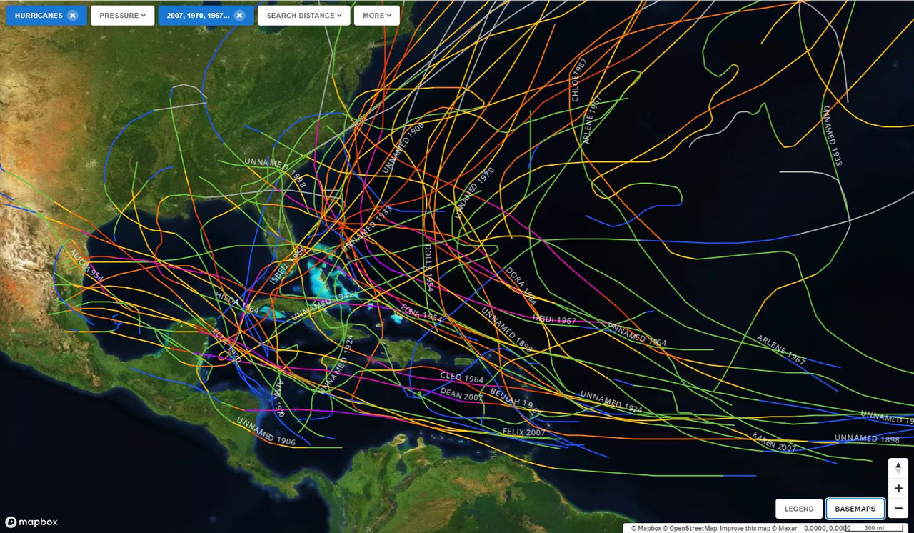
This map represents all hurricane tracks in the Atlantic Basin during years where there was a developing La Nina going into hurricane season and the strength was weak to moderate during ASO.
Years used (Very unscientific): 1898,1906, 1924, 1933, 1938, 1942, 1954, 1964, 1967, 1970, 2007 (I'm sure I missed a few).
The spray of storms is focused more west in the basin and is definitely in line with 2024 early season predictions and consistent IMO of stronger ridging and La Nina influence.
I assume adding the extra SST fuel and lower shear results in a very active season and there are a few representatives of this in the sample group.
2 likes
Hurricane Eye Experience: David 79, Irene 99, Frances 04, Jeanne 04, Wilma 05… Hurricane Brush Experience: Andrew 92, Erin 95, Floyd 99, Matthew 16, Irma 17, Ian 22, Nicole 22…
-
cycloneye
- Admin
- Posts: 149338
- Age: 69
- Joined: Thu Oct 10, 2002 10:54 am
- Location: San Juan, Puerto Rico
Re: Very early thoughts on the 2024 Atlantic hurricane season
Blown Away wrote:[url]https://i.postimg.cc/GpS2ZsyN/La-Nina-Years.jpg [/url]
This map represents all hurricane tracks in the Atlantic Basin during years where there was a developing La Nina going into hurricane season and the strength was weak to moderate during ASO.
Years used (Very unscientific): 1898,1906, 1924, 1933, 1938, 1942, 1954, 1964, 1967, 1970, 2007 (I'm sure I missed a few).
The spray of storms is focused more west in the basin and is definitely in line with 2024 early season predictions and consistent IMO of stronger ridging and La Nina influence.
I assume adding the extra SST fuel and lower shear results in a very active season and there are a few representatives of this in the sample group.
What I dont like at all is the very active Caribbean among those years mentioned.
0 likes
Visit the Caribbean-Central America Weather Thread where you can find at first post web cams,radars
and observations from Caribbean basin members Click Here
and observations from Caribbean basin members Click Here
-
cycloneye
- Admin
- Posts: 149338
- Age: 69
- Joined: Thu Oct 10, 2002 10:54 am
- Location: San Juan, Puerto Rico
Re: 2024 Indicators: SST's, MSLP, Shear, SAL, Steering, Instability (Day 16+ Climate Models)
As I posted yesterday, not a lot of a drop.
https://twitter.com/AndyHazelton/status/1761012386859729359
https://twitter.com/AndyHazelton/status/1761012386859729359
0 likes
Visit the Caribbean-Central America Weather Thread where you can find at first post web cams,radars
and observations from Caribbean basin members Click Here
and observations from Caribbean basin members Click Here
-
DorkyMcDorkface

- Category 4

- Posts: 997
- Age: 28
- Joined: Mon Sep 30, 2019 1:32 pm
- Location: Mid-Atlantic
Re: 2024 Indicators: SST's, MSLP, Shear, SAL, Steering, Instability (Day 16+ Climate Models)
cycloneye wrote:As I posted yesterday, not a lot of a drop.
https://twitter.com/AndyHazelton/status/1761012386859729359
https://twitter.com/cyclonicwx/status/1761185573480341747
3 likes
Please note the thoughts expressed by this account are solely those of the user and are from a hobbyist perspective. For more comprehensive analysis, consult an actual professional meteorologist or meteorological agency.
Floyd 1999 | Isabel 2003 | Hanna 2008 | Irene 2011 | Sandy 2012 | Isaias 2020
-
DorkyMcDorkface
- Category 4
- Posts: 997
- Age: 28
- Joined: Mon Sep 30, 2019 1:32 pm
- Location: Mid-Atlantic
Re: 2024 Indicators: SST's, MSLP, Shear, SAL, Steering, Instability (Day 16+ Climate Models)
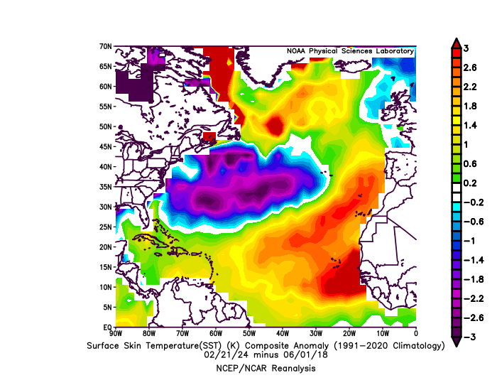
In case you're looking for a (nervous?) laugh: SSTs now subtracted from how they looked at the start of the 2018 hurricane season.
4 likes
Please note the thoughts expressed by this account are solely those of the user and are from a hobbyist perspective. For more comprehensive analysis, consult an actual professional meteorologist or meteorological agency.
Floyd 1999 | Isabel 2003 | Hanna 2008 | Irene 2011 | Sandy 2012 | Isaias 2020
-
mixedDanilo.E
- Tropical Storm

- Posts: 109
- Joined: Sun Nov 21, 2021 8:00 am
- Location: NY
Re: 2024 Indicators: SST's, MSLP, Shear, SAL, Steering, Instability (Day 16+ Climate Models)
DorkyMcDorkface wrote:In case you're looking for a (nervous?) laugh: SSTs now subtracted from how they looked at the start of the 2018 hurricane season.
https://uploads.disquscdn.com/images/290a2edf5059ab5a13a8f35ac426bd5ba0e91ccce567a2c6c842b818dce89281.gif
quite literally the exact opposite - incredible!
0 likes
-
DorkyMcDorkface
- Category 4
- Posts: 997
- Age: 28
- Joined: Mon Sep 30, 2019 1:32 pm
- Location: Mid-Atlantic
Re: 2024 Indicators: SST's, MSLP, Shear, SAL, Steering, Instability (Day 16+ Climate Models)
mixedDanilo.E wrote:DorkyMcDorkface wrote:In case you're looking for a (nervous?) laugh: SSTs now subtracted from how they looked at the start of the 2018 hurricane season.
https://uploads.disquscdn.com/images/290a2edf5059ab5a13a8f35ac426bd5ba0e91ccce567a2c6c842b818dce89281.gif
quite literally the exact opposite - incredible!
Yeah just about...
6 likes
Please note the thoughts expressed by this account are solely those of the user and are from a hobbyist perspective. For more comprehensive analysis, consult an actual professional meteorologist or meteorological agency.
Floyd 1999 | Isabel 2003 | Hanna 2008 | Irene 2011 | Sandy 2012 | Isaias 2020
-
Hurricane2022

- Category 5
- Posts: 2016
- Joined: Tue Aug 23, 2022 11:38 pm
- Location: Araçatuba, Brazil
Re: 2024 Indicators: SST's, MSLP, Shear, SAL, Steering, Instability (Day 16+ Climate Models)
DorkyMcDorkface wrote:In case you're looking for a (nervous?) laugh: SSTs now subtracted from how they looked at the start of the 2018 hurricane season.
https://uploads.disquscdn.com/images/290a2edf5059ab5a13a8f35ac426bd5ba0e91ccce567a2c6c842b818dce89281.gif
I think we need a "nervous laughing" Smilie ASAP. It would be very useful before and during this 2024 season.
2 likes
Sorry for the bad English sometimes...!
For reliable and detailed information for any meteorological phenomenon, please consult the National Hurricane Center, Joint Typhoon Warning Center , or your local Meteo Center.
--------
ECCE OMNIA NOVA FACIAM (Ap 21,5).
For reliable and detailed information for any meteorological phenomenon, please consult the National Hurricane Center, Joint Typhoon Warning Center , or your local Meteo Center.
--------
ECCE OMNIA NOVA FACIAM (Ap 21,5).
-
cycloneye
- Admin
- Posts: 149338
- Age: 69
- Joined: Thu Oct 10, 2002 10:54 am
- Location: San Juan, Puerto Rico
Re: 2024 Indicators: SST's, MSLP, Shear, SAL, Steering, Instability (Day 16+ Climate Models)
DorkyMcDorkface wrote:mixedDanilo.E wrote:DorkyMcDorkface wrote:In case you're looking for a (nervous?) laugh: SSTs now subtracted from how they looked at the start of the 2018 hurricane season.
https://uploads.disquscdn.com/images/290a2edf5059ab5a13a8f35ac426bd5ba0e91ccce567a2c6c842b818dce89281.gif
quite literally the exact opposite - incredible!
Yeah just about...
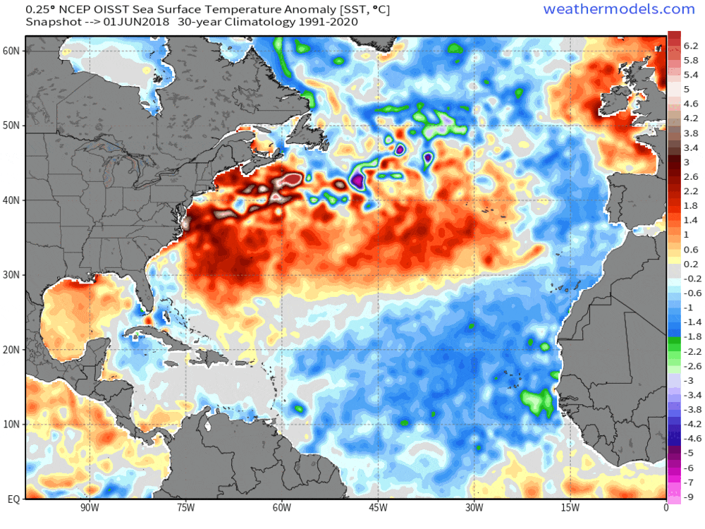
https://uploads.disquscdn.com/images/3387b2d70141329b01b4656fb87072330a86290cb9b837939dbe05a23468f4df.gif
Not only is the MDR very warm, but also the Caribbean and that is what worries me the most, as I and many members of S2K live in these neck of the woods.
1 likes
Visit the Caribbean-Central America Weather Thread where you can find at first post web cams,radars
and observations from Caribbean basin members Click Here
and observations from Caribbean basin members Click Here

Re: 2024 Indicators: SST's, MSLP, Shear, SAL, Steering, Instability (Day 16+ Climate Models)
cycloneye wrote:DorkyMcDorkface wrote:mixedDanilo.E wrote:
quite literally the exact opposite - incredible!
Yeah just about...
https://uploads.disquscdn.com/images/3387b2d70141329b01b4656fb87072330a86290cb9b837939dbe05a23468f4df.gif
Not only is the MDR very warm, but also the Caribbean and that is what worries me the most, as I and many members of S2K live in these neck of the woods.
I’m probably in the minority on this but I really don’t care much about how warm the waters are east of 60W.
0 likes
-
Hurricane2022
- Category 5
- Posts: 2016
- Joined: Tue Aug 23, 2022 11:38 pm
- Location: Araçatuba, Brazil
Re: 2024 Indicators: SST's, MSLP, Shear, SAL, Steering, Instability (Day 16+ Climate Models)
Cpv17 wrote:cycloneye wrote:DorkyMcDorkface wrote:Yeah just about...
https://uploads.disquscdn.com/images/3387b2d70141329b01b4656fb87072330a86290cb9b837939dbe05a23468f4df.gif
Not only is the MDR very warm, but also the Caribbean and that is what worries me the most, as I and many members of S2K live in these neck of the woods.
I’m probably in the minority on this but I really don’t care much about how warm the waters are east of 60W.
But it would be important to observe the situation there, since we don't know if we can have something strong there that could cause problems somewhere close to the USA or the Caribbean, like some systems similar to Irma and Isabel...
Sometimes they are little things that may seem insignificant but sooner or later they can end up being big enemies for us if we ignore them, even if it is for a brief moment, for example the aforementioned Irma. If I'm not mistaken, at the beginning of his life that guy seemed to pose no significant risk to Florida, Cuba... But time passed and the worse happened. It was horrible but it could have been even worse.
4 likes
Sorry for the bad English sometimes...!
For reliable and detailed information for any meteorological phenomenon, please consult the National Hurricane Center, Joint Typhoon Warning Center , or your local Meteo Center.
--------
ECCE OMNIA NOVA FACIAM (Ap 21,5).
For reliable and detailed information for any meteorological phenomenon, please consult the National Hurricane Center, Joint Typhoon Warning Center , or your local Meteo Center.
--------
ECCE OMNIA NOVA FACIAM (Ap 21,5).
-
NotSparta

- Professional-Met

- Posts: 1677
- Age: 24
- Joined: Fri Aug 18, 2017 8:24 am
- Location: Naples, FL
- Contact:
Re: 2024 Indicators: SST's, MSLP, Shear, SAL, Steering, Instability (Day 16+ Climate Models)
Cpv17 wrote:cycloneye wrote:DorkyMcDorkface wrote:Yeah just about...
https://uploads.disquscdn.com/images/3387b2d70141329b01b4656fb87072330a86290cb9b837939dbe05a23468f4df.gif
Not only is the MDR very warm, but also the Caribbean and that is what worries me the most, as I and many members of S2K live in these neck of the woods.
I’m probably in the minority on this but I really don’t care much about how warm the waters are east of 60W.
That's a big part of what controls how active the season is so it's not something to ignore
8 likes
This post was probably an opinion of mine, and in no way is official. Please refer to http://www.hurricanes.gov for official tropical analysis and advisories.
My website, with lots of tropical wx graphics, including satellite and recon: http://cyclonicwx.com
My website, with lots of tropical wx graphics, including satellite and recon: http://cyclonicwx.com
-
DorkyMcDorkface
- Category 4
- Posts: 997
- Age: 28
- Joined: Mon Sep 30, 2019 1:32 pm
- Location: Mid-Atlantic
Re: 2024 Indicators: SST's, MSLP, Shear, SAL, Steering, Instability (Day 16+ Climate Models)
Cpv17 wrote:cycloneye wrote:DorkyMcDorkface wrote:Yeah just about...
https://uploads.disquscdn.com/images/3387b2d70141329b01b4656fb87072330a86290cb9b837939dbe05a23468f4df.gif
Not only is the MDR very warm, but also the Caribbean and that is what worries me the most, as I and many members of S2K live in these neck of the woods.
I’m probably in the minority on this but I really don’t care much about how warm the waters are east of 60W.
That area has the highest correlation with seasonal activity though.
4 likes
Please note the thoughts expressed by this account are solely those of the user and are from a hobbyist perspective. For more comprehensive analysis, consult an actual professional meteorologist or meteorological agency.
Floyd 1999 | Isabel 2003 | Hanna 2008 | Irene 2011 | Sandy 2012 | Isaias 2020
-
weeniepatrol

- Category 5
- Posts: 1343
- Joined: Sat Aug 22, 2020 5:30 pm
- Location: WA State
Re: 2024 Indicators: SST's, MSLP, Shear, SAL, Steering, Instability (Day 16+ Climate Models)
DorkyMcDorkface wrote:Cpv17 wrote:cycloneye wrote:
Not only is the MDR very warm, but also the Caribbean and that is what worries me the most, as I and many members of S2K live in these neck of the woods.
I’m probably in the minority on this but I really don’t care much about how warm the waters are east of 60W.
That area has the highest correlation with seasonal activity though.
To be fair, this early in the year, it does not.
https://twitter.com/philklotzbach/status/1266107330417979392
3 likes
-
cycloneye
- Admin
- Posts: 149338
- Age: 69
- Joined: Thu Oct 10, 2002 10:54 am
- Location: San Juan, Puerto Rico
Re: 2024 Indicators: SST's, MSLP, Shear, SAL, Steering, Instability (Day 16+ Climate Models)
Can I say those famouus words? "Season Cancelled" 

2 likes
Visit the Caribbean-Central America Weather Thread where you can find at first post web cams,radars
and observations from Caribbean basin members Click Here
and observations from Caribbean basin members Click Here
Re: 2024 Indicators: SST's, MSLP, Shear, SAL, Steering, Instability (Day 16+ Climate Models)
NotSparta wrote:Cpv17 wrote:cycloneye wrote:
Not only is the MDR very warm, but also the Caribbean and that is what worries me the most, as I and many members of S2K live in these neck of the woods.
I’m probably in the minority on this but I really don’t care much about how warm the waters are east of 60W.
That's a big part of what controls how active the season is so it's not something to ignore
Yeah but if they form out there (depending on the steering, of course) a lot of those won’t impact land and your average person doesn’t give 2 cents about fish storms. Fish storms are for the true weather nerds to marvel over.
0 likes
Who is online
Users browsing this forum: No registered users and 77 guests