2023 EPAC Season

This is the general tropical discussion area. Anyone can take their shot at predicting a storms path.

Moderator: S2k Moderators

Forum rules

The posts in this forum are NOT official forecasts and should not be used as such. They are just the opinion of the poster and may or may not be backed by sound meteorological data. They are NOT endorsed by any professional institution or STORM2K. For official information, please refer to products from the National Hurricane Center and National Weather Service.

Help Support Storm2K
Message
Author
User avatar
cycloneye
Admin
Admin
Posts: 145282
Age: 68
Joined: Thu Oct 10, 2002 10:54 am
Location: San Juan, Puerto Rico

Re: 2023 EPAC Season

#301 Postby cycloneye » Sat Jul 29, 2023 6:45 am

Tropical Weather Outlook
NWS National Hurricane Center Miami FL
500 AM PDT Sat Jul 29 2023

For the eastern North Pacific...east of 140 degrees west longitude:

1. Offshore of Southern Mexico:
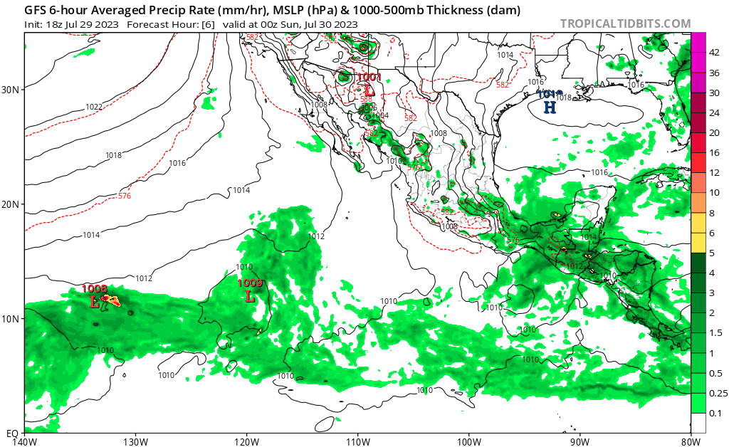
A tropical wave located over the far eastern Pacific south of the
coast of El Salvador is producing a large area of disorganized
showers and thunderstorms. This system is forecast to move generally
westward, and an area of low pressure is expected to form off the
coast of southern Mexico later this weekend. Thereafter, gradual
development of this system is forecast and a tropical depression
will likely form early next week while it moves west-northwestward
at 10 to 15 mph, roughly parallel to the coasts of southern and
southwestern Mexico.
* Formation chance through 48 hours...low...30 percent.
* Formation chance through 7 days...high...80 percent.

Forecaster Bucci
0 likes   
Visit the Caribbean-Central America Weather Thread where you can find at first post web cams,radars
and observations from Caribbean basin members Click Here

User avatar
cycloneye
Admin
Admin
Posts: 145282
Age: 68
Joined: Thu Oct 10, 2002 10:54 am
Location: San Juan, Puerto Rico

Re: 2023 EPAC Season

#302 Postby cycloneye » Sat Jul 29, 2023 12:36 pm

Tropical Weather Outlook
NWS National Hurricane Center Miami FL
1100 AM PDT Sat Jul 29 2023

For the eastern North Pacific...east of 140 degrees west longitude:

1. Offshore of Southern Mexico:
A tropical wave located south of the coast of Guatemala is producing
a large area of disorganized showers and thunderstorms.
Environmental conditions are conducive for gradual development, and
a tropical depression will likely form early next week while the
system moves west-northwestward at 10 to 15 mph, roughly parallel to
the coasts of southern and southwestern Mexico.
* Formation chance through 48 hours...medium...40 percent.
* Formation chance through 7 days...high...80 percent.

Forecaster Bucci
0 likes   
Visit the Caribbean-Central America Weather Thread where you can find at first post web cams,radars
and observations from Caribbean basin members Click Here

User avatar
cycloneye
Admin
Admin
Posts: 145282
Age: 68
Joined: Thu Oct 10, 2002 10:54 am
Location: San Juan, Puerto Rico

Re: 2023 EPAC Season

#303 Postby cycloneye » Sat Jul 29, 2023 1:20 pm

Invest 96E is up.
0 likes   
Visit the Caribbean-Central America Weather Thread where you can find at first post web cams,radars
and observations from Caribbean basin members Click Here

User avatar
gatorcane
S2K Supporter
S2K Supporter
Posts: 23691
Age: 47
Joined: Sun Mar 13, 2005 3:54 pm
Location: Boca Raton, FL

Re: 2023 EPAC Season

#304 Postby gatorcane » Sat Jul 29, 2023 8:27 pm

Looks like the lid is coming off in the EPAC with the GFS showing three hurricanes in the next 14 days. Given the strengthening El Nino, I expect the EPAC to crank out a lot of hurricanes this season with several majors:

Saved loop:
Image
0 likes   

User avatar
Category5Kaiju
Category 5
Category 5
Posts: 4095
Joined: Thu Dec 24, 2020 12:45 pm
Location: Seattle

Re: 2023 EPAC Season

#305 Postby Category5Kaiju » Sat Jul 29, 2023 8:31 pm

gatorcane wrote:Looks like the lid is coming off in the EPAC with the GFS showing three hurricanes in the next 14 days. Given the strengthening El Nino, I expect the EPAC to crank out a lot of hurricanes this season.

Saved loop:
https://i.postimg.cc/VLCqGMKx/gfs-mslp-pcpn-epac-fh6-384.gif


Just out of curiosity, what are your thoughts on the -PDO?
0 likes   
Unless explicitly stated, all info in my posts is based on my own opinions and observations. Tropical storms and hurricanes can be extremely dangerous. Do not think you can beat Mother Nature. Refer to an accredited weather research agency or meteorologist if you need to make serious decisions regarding an approaching storm.

User avatar
Hurricane2022
Category 5
Category 5
Posts: 1541
Joined: Tue Aug 23, 2022 11:38 pm
Location: Araçatuba, Brazil

Re: 2023 EPAC Season

#306 Postby Hurricane2022 » Sat Jul 29, 2023 9:25 pm

gatorcane wrote:Looks like the lid is coming off in the EPAC with the GFS showing three hurricanes in the next 14 days. Given the strengthening El Nino, I expect the EPAC to crank out a lot of hurricanes this season with several majors:

Saved loop:
https://i.postimg.cc/VLCqGMKx/gfs-mslp-pcpn-epac-fh6-384.gif

I rarely believe any GFS prediction after TAU 180.
1 likes   
Sorry for the bad English sometimes...!
For reliable and detailed information for any meteorological phenomenon, please consult the National Hurricane Center, Joint Typhoon Warning Center , or your local Meteo Center.

--------

Una cvm Christo, pro Christo, et in Christo. Sit nomen Domini benedictvm.

User avatar
Kingarabian
S2K Supporter
S2K Supporter
Posts: 15979
Joined: Sat Aug 08, 2009 3:06 am
Location: Honolulu, Hawaii

Re: 2023 EPAC Season

#307 Postby Kingarabian » Sat Jul 29, 2023 9:47 pm

gatorcane wrote:Looks like the lid is coming off in the EPAC with the GFS showing three hurricanes in the next 14 days. Given the strengthening El Nino, I expect the EPAC to crank out a lot of hurricanes this season with several majors:

Saved loop:
https://i.postimg.cc/VLCqGMKx/gfs-mslp-pcpn-epac-fh6-384.gif

2 of the 3 systems look believable although the Euro and CMC don't agree much on intensity.
1 likes   
RIP Kobe Bryant

User avatar
gatorcane
S2K Supporter
S2K Supporter
Posts: 23691
Age: 47
Joined: Sun Mar 13, 2005 3:54 pm
Location: Boca Raton, FL

Re: 2023 EPAC Season

#308 Postby gatorcane » Sun Jul 30, 2023 12:13 pm

The 12Z GFS now shows four hurricanes forming in the EPAC over the next 14 days. :double:

Image
0 likes   

User avatar
cycloneye
Admin
Admin
Posts: 145282
Age: 68
Joined: Thu Oct 10, 2002 10:54 am
Location: San Juan, Puerto Rico

Re: 2023 EPAC Season

#309 Postby cycloneye » Sun Jul 30, 2023 1:21 pm

Southwest of southern Baja California:
A small area of low pressure located about 1100 miles southwest of
the southern tip of Baja California is producing a few showers and
thunderstorms. Significant development of this system is unlikely
while it moves westward at 10 to 15 mph over the next couple of
days.
* Formation chance through 48 hours...low...10 percent.
* Formation chance through 7 days...low...10 percent.
0 likes   
Visit the Caribbean-Central America Weather Thread where you can find at first post web cams,radars
and observations from Caribbean basin members Click Here

User avatar
Yellow Evan
Professional-Met
Professional-Met
Posts: 16143
Age: 27
Joined: Fri Jul 15, 2011 12:48 pm
Location: Henderson, Nevada/Honolulu, HI
Contact:

Re: 2023 EPAC Season

#310 Postby Yellow Evan » Sun Jul 30, 2023 2:14 pm

:uarrow: Clear TC btw.

Image

Image
0 likes   

zzzh
Category 3
Category 3
Posts: 834
Joined: Thu Sep 02, 2021 1:13 pm

Re: 2023 EPAC Season

#311 Postby zzzh » Sun Jul 30, 2023 2:56 pm

Image
Yep, this is a TD.
0 likes   

User avatar
cycloneye
Admin
Admin
Posts: 145282
Age: 68
Joined: Thu Oct 10, 2002 10:54 am
Location: San Juan, Puerto Rico

Re: 2023 EPAC Season

#312 Postby cycloneye » Sun Jul 30, 2023 6:45 pm

Here comes the other one models develop.

South of Southwestern Mexico:
An area of low pressure could form late this week a few hundred
miles south of the coast of southwestern Mexico. Some gradual
development is possible by the upcoming weekend while the system
moves west-northwestward or northwestward, roughly parallel to the
southwestern coast of Mexico.
* Formation chance through 48 hours...low...near 0 percent.
* Formation chance through 7 days...low...20 percent.


Southwest of southern Baja California:
A small area of low pressure located about 1100 miles southwest of
the southern tip of Baja California is still producing a few
showers and thunderstorms. Significant development of this system
is unlikely due to strong upper-level winds while it moves westward
at 10 to 15 mph during the next couple of days.
* Formation chance through 48 hours...low...10 percent.
* Formation chance through 7 days...low...10 percent.


Image
0 likes   
Visit the Caribbean-Central America Weather Thread where you can find at first post web cams,radars
and observations from Caribbean basin members Click Here

User avatar
ElectricStorm
Category 5
Category 5
Posts: 5044
Age: 24
Joined: Tue Aug 13, 2019 11:23 pm
Location: Skiatook, OK / Norman, OK

Re: 2023 EPAC Season

#313 Postby ElectricStorm » Sun Jul 30, 2023 6:48 pm

Not really sure why it's still 10/10 when it has a closed circulation...
0 likes   
B.S Meteorology, University of Oklahoma '25

Please refer to the NHC, NWS, or SPC for official information.

User avatar
cycloneye
Admin
Admin
Posts: 145282
Age: 68
Joined: Thu Oct 10, 2002 10:54 am
Location: San Juan, Puerto Rico

Re: 2023 EPAC Season

#314 Postby cycloneye » Mon Jul 31, 2023 6:54 am

8 AM TWO:

2. Central East Pacific:
A small area of low pressure located about 1100 miles southwest of
the southern tip of the Baja California Peninsula continues to
produce an area of disorganized showers and thunderstorms.
Conditions do not appear to be conducive for development of this
system while it moves westward at 10 to 15 mph during the next
couple of days.
* Formation chance through 48 hours...low...10 percent.
* Formation chance through 7 days...low...10 percent.

3. South of Southwestern Mexico:
An area of low pressure could form late this week a few hundred
miles south of the coast of southwestern Mexico. Some gradual
development is possible by the upcoming weekend while the system
moves west-northwestward or northwestward, roughly parallel to the
southwestern coast of Mexico.
* Formation chance through 48 hours...low...near 0 percent.
* Formation chance through 7 days...low...20 percent.
0 likes   
Visit the Caribbean-Central America Weather Thread where you can find at first post web cams,radars
and observations from Caribbean basin members Click Here

User avatar
cycloneye
Admin
Admin
Posts: 145282
Age: 68
Joined: Thu Oct 10, 2002 10:54 am
Location: San Juan, Puerto Rico

Re: 2023 EPAC Season

#315 Postby cycloneye » Mon Jul 31, 2023 12:59 pm

11 AM Pacific:

2. Central East Pacific:
A small area of low pressure located about 1100 miles southwest of
the southern tip of the Baja California Peninsula continues to
produce an area of disorganized showers and thunderstorms. The
proximity of nearby dry air is likely to prevent significant
development of this system while it moves westward at 5 to 10 mph
during the next couple of days.
* Formation chance through 48 hours...low...10 percent.
* Formation chance through 7 days...low...10 percent.

3. South of Southwestern Mexico:
An area of low pressure could form towards the end of this week a
few hundred miles south of the coast of southwestern Mexico. Some
gradual development of this system is possible by the weekend while
it moves west-northwestward or northwestward, roughly parallel to
the southwestern coast of Mexico.
* Formation chance through 48 hours...low...near 0 percent.
* Formation chance through 7 days...low...30 percent.
0 likes   
Visit the Caribbean-Central America Weather Thread where you can find at first post web cams,radars
and observations from Caribbean basin members Click Here

User avatar
Yellow Evan
Professional-Met
Professional-Met
Posts: 16143
Age: 27
Joined: Fri Jul 15, 2011 12:48 pm
Location: Henderson, Nevada/Honolulu, HI
Contact:

Re: 2023 EPAC Season

#316 Postby Yellow Evan » Mon Jul 31, 2023 1:47 pm

GFS has a fantastic UL environment and as a result consistently goes below 950 mbar. ECMWF barely has any development.
1 likes   

User avatar
Ntxw
Storm2k Moderator
Storm2k Moderator
Posts: 22783
Joined: Wed Oct 21, 2009 6:34 pm
Location: DFW, Texas

Re: 2023 EPAC Season

#317 Postby Ntxw » Mon Jul 31, 2023 7:05 pm

Could be two big hurricanes simultaneously at some point if the second one is real from the models.
1 likes   
The above post and any post by Ntxw is NOT an official forecast and should not be used as such. It is just the opinion of the poster and may or may not be backed by sound meteorological data. It is NOT endorsed by any professional institution including Storm2k. For official information, please refer to NWS products.

  Help support Storm2K!
Help Support Storm2K

User avatar
cycloneye
Admin
Admin
Posts: 145282
Age: 68
Joined: Thu Oct 10, 2002 10:54 am
Location: San Juan, Puerto Rico

Re: 2023 EPAC Season

#318 Postby cycloneye » Mon Jul 31, 2023 7:48 pm

South of Southwestern Mexico:
An area of low pressure could form late this week a few hundred
miles south of the coast of southwestern Mexico. Some gradual
development of this system is possible by the weekend while it
moves west-northwestward or northwestward, roughly parallel to
the southwestern coast of Mexico.
* Formation chance through 48 hours...low...near 0 percent.
* Formation chance through 7 days...low...30 percent.
0 likes   
Visit the Caribbean-Central America Weather Thread where you can find at first post web cams,radars
and observations from Caribbean basin members Click Here

User avatar
cycloneye
Admin
Admin
Posts: 145282
Age: 68
Joined: Thu Oct 10, 2002 10:54 am
Location: San Juan, Puerto Rico

Re: 2023 EPAC Season

#319 Postby cycloneye » Tue Aug 01, 2023 10:55 am

It looks like this basin will surpass in a easy way, the average ACE threshold with Dora and future Eugene. As of August 1, is below average with 43.3 vs 25.4.

Source=CSU.

http://tropical.atmos.colostate.edu/Realtime/
0 likes   
Visit the Caribbean-Central America Weather Thread where you can find at first post web cams,radars
and observations from Caribbean basin members Click Here

User avatar
cycloneye
Admin
Admin
Posts: 145282
Age: 68
Joined: Thu Oct 10, 2002 10:54 am
Location: San Juan, Puerto Rico

Re: 2023 EPAC Season

#320 Postby cycloneye » Tue Aug 01, 2023 12:40 pm

Off the coast of Southwestern Mexico:
An area of low pressure is forecast to form towards the latter part
of this week a few hundred miles south of the coast of southwestern
Mexico. Thereafter, some gradual development of this system is
possible, and a tropical depression could form by early next week
while it moves west-northwestward or northwestward, roughly parallel
to the southwestern coast of Mexico.
* Formation chance through 48 hours...low...near 0 percent.
* Formation chance through 7 days...medium...50 percent.
0 likes   
Visit the Caribbean-Central America Weather Thread where you can find at first post web cams,radars
and observations from Caribbean basin members Click Here


Return to “Talkin' Tropics”

Who is online

Users browsing this forum: Google Adsense [Bot], Stormybajan, Ulf and 30 guests