
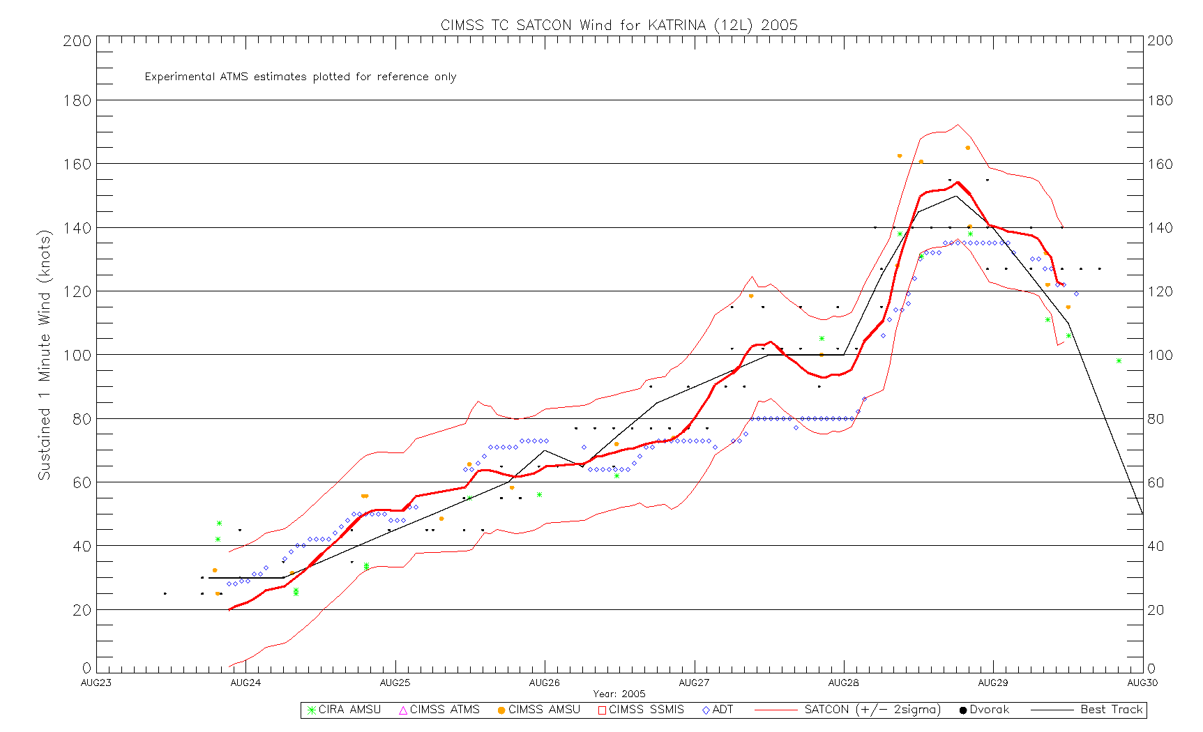
Just eyeballing, I might do 135 kt for 00Z (W/a deep OW), 130 kt for 06Z (B/a not so deep OW), and 135 kt again for 12Z (B/WMG following up B/WMG w/W ring form 09Z) before coming down.
Moderator: S2k Moderators


Chris90 wrote:I've taken a look back this evening at the 1988 season after reading the personal analysis you both have presented, and I'm thinking there is a good chance both Helene and Joan did reach Category 5 status. I'm also struck by the similarities between the 1988 and 2007 seasons. Dean following a similar track to Gilbert and Felix following a Joan-esque one. Looking at some satellite images and loops of Joan, there are definitely some moments when I'm reminded of Felix, and I'm thinking based on the size of the storm and the pressures, Joan could quite possibly have peaked with 140-150kts, in fact, I think it's more likely than not.
I'd be interested to see some KZC analysis on Joan to see what the outputs would be. I know I've seen some KZC analysis done by some users on the forum, but it's beyond my skill level.
1900hurricane wrote:Chris90 wrote:I've taken a look back this evening at the 1988 season after reading the personal analysis you both have presented, and I'm thinking there is a good chance both Helene and Joan did reach Category 5 status. I'm also struck by the similarities between the 1988 and 2007 seasons. Dean following a similar track to Gilbert and Felix following a Joan-esque one. Looking at some satellite images and loops of Joan, there are definitely some moments when I'm reminded of Felix, and I'm thinking based on the size of the storm and the pressures, Joan could quite possibly have peaked with 140-150kts, in fact, I think it's more likely than not.
I'd be interested to see some KZC analysis on Joan to see what the outputs would be. I know I've seen some KZC analysis done by some users on the forum, but it's beyond my skill level.
I use KZC quite a bit since I've written a few Python programs that can implement it pretty quickly. Probably the biggest issue with running it for Joan '88 would involve deriving the S parameter, which approximates storm size. The two most common ways to derive it are from TS wind radii and from the radius of the outermost closed isobar, both of which may be a pain digging up for Joan. I could probably figure something out though once I have some free time, even if it's just something as simple as eyeballing it and using a confidence interval.


galaxy401 wrote:These HURDAT reanalysis are going to get more interesting now that we are in the satellite era. If a storm like Hugo, Felix, or Helen existed now, what intensity would they be assessed? Jose is the closest example we have since then it seems.
Ptarmigan wrote:I happen to look at re-analysis from 1931 to 1943.
Documentation for 1931 to 1943
http://www.aoml.noaa.gov/hrd/Landsea/la ... e-2014.pdf
I noticed the 1935 Labor Day Hurricane had a large radius of outer closed isobars (ROCI). It has a ROCI of 300 nautical miles, which is quite large. If I recall, the hurricane prior to hitting Florida Keys had hurricane force winds extending up to 15 miles.
CrazyC83 wrote:galaxy401 wrote:These HURDAT reanalysis are going to get more interesting now that we are in the satellite era. If a storm like Hugo, Felix, or Helen existed now, what intensity would they be assessed? Jose is the closest example we have since then it seems.
We learned a lot even in the last few years. We could probably do a reanalysis almost right up to recent seasons, as the SFMR became operational in 2007 (it was experimental from 2003-06) and SATCON came around when, 2010?
1900hurricane wrote:Ptarmigan wrote:I happen to look at re-analysis from 1931 to 1943.
Documentation for 1931 to 1943
http://www.aoml.noaa.gov/hrd/Landsea/la ... e-2014.pdf
I noticed the 1935 Labor Day Hurricane had a large radius of outer closed isobars (ROCI). It has a ROCI of 300 nautical miles, which is quite large. If I recall, the hurricane prior to hitting Florida Keys had hurricane force winds extending up to 15 miles.
Just saw this. Here's what I get when I plug that ROCI of 300 nm and OCI of 1010 mb into KZC when coupled with the 892 mb pressure, 7.4 kt forward speed, and 24.8ºN landfall latitude.>>> from KZCeq import KZC, KZCroci
>>> v = 100
>>> oci = 1010
>>> p0 = 1000
>>> c = 7.4
>>> p = 892
>>> l = 24.8
>>> while p0 > p:
v = v + 0.1
p0 = KZC(KZCroci(v, c, roci, l), oci)
>>> print("%3.0f" % v)
167
That 167 kt is more intense than in best track. When rounded to 165 kt, that KZC output would tie Allen '80 for the highest LMI for the NAtl.
Shell Mound wrote:1900hurricane wrote:Ptarmigan wrote:I happen to look at re-analysis from 1931 to 1943.
Documentation for 1931 to 1943
http://www.aoml.noaa.gov/hrd/Landsea/la ... e-2014.pdf
I noticed the 1935 Labor Day Hurricane had a large radius of outer closed isobars (ROCI). It has a ROCI of 300 nautical miles, which is quite large. If I recall, the hurricane prior to hitting Florida Keys had hurricane force winds extending up to 15 miles.
Just saw this. Here's what I get when I plug that ROCI of 300 nm and OCI of 1010 mb into KZC when coupled with the 892 mb pressure, 7.4 kt forward speed, and 24.8ºN landfall latitude.>>> from KZCeq import KZC, KZCroci
>>> v = 100
>>> oci = 1010
>>> p0 = 1000
>>> c = 7.4
>>> p = 892
>>> l = 24.8
>>> while p0 > p:
v = v + 0.1
p0 = KZC(KZCroci(v, c, roci, l), oci)
>>> print("%3.0f" % v)
167
That 167 kt is more intense than in best track. When rounded to 165 kt, that KZC output would tie Allen '80 for the highest LMI for the NAtl.
This is a very good baseline for establishing intensity, but it can be improved further, when adjusting for other variables. Wouldn't accounting for the intensity trend (rapidly deepening) and RMW (~5 n mi, much smaller than climatology for its location) add at least ten knots to the KZC output? I, personally, would assume that these factors would bump up the baseline from 165 to at least 175 knots, and that the actual winds were likely similar to Patricia's or Haiyan's (185 to 190 knots). Is that a reasonable guess to you?
Code: Select all
V500 = r34 / 9 - 3
Rmax = 66.785 - 0.09102 * v + 1.0619 * (lat - 25)
X = 0.1147 + 0.0055 * v - 0.001 * (lat - 25)
V500c = v * (Rmax / 500) ** X
S = V500 / V500c
Code: Select all
S = (roci / 60) / 8 + 0.1
Shell Mound wrote:CrazyC83 wrote:Earlier I took a look at majors up to 1978 (although some may warrant further revision). Now here is my thought for the major hurricanes (either in the best track or that I believe were such) from 1979 to 1994 (i.e. before the most recent era):
1979 - David (BT 150 kt, no change), Frederic (BT 115 kt, no change)
1980 - Allen (BT 165 kt, no change), Frances (BT 100 kt, increase to 125 kt), Ivan (BT 90 kt, increase to 100 kt)
1981 - Harvey (BT 115 kt, no change), Irene (BT 105 kt, no change); REMOVED: Floyd (BT 100 kt, decrease to 85 kt)
1982 - no majors; REMOVED: Debby (BT 115 kt, decrease to 95 kt)
1983 - no majors; REMOVED: Alicia (BT 100 kt, decrease to 90 kt)
1984 - Diana (BT 115 kt, no change)
1985 - Elena (BT 110 kt, no change), Gloria (BT 125 kt, increase to 135 kt), Kate (BT 105 kt, decrease to 100 kt)
1986 - no majors
1987 - Emily (BT 110 kt, increase to 120 kt)
1988 - Gilbert (BT 160 kt, increase to 170 kt), Helene (BT 125 kt, increase to 140 kt), Joan (BT 125 kt, no change)
1989 - Gabrielle (BT 125 kt, no change), Hugo (BT 140 kt, increase to 150 kt)
1990 - Gustav (BT 105 kt, no change)
1991 - Bob (BT 100 kt, increase to 110 kt)
1992 - Andrew (BT 150 kt, increase to 160 kt)
1993 - Emily (BT 100 kt, increase to 110 kt)
1994 - no majors
The biggest increase is with Frances 1980 (best analysis is T6.5, before even reaching 30W longitude!) while Debby is the biggest decrease (no evidence it was higher than T5.0 looking at satellite).
My own tidbits, to be taken for what they are worth:
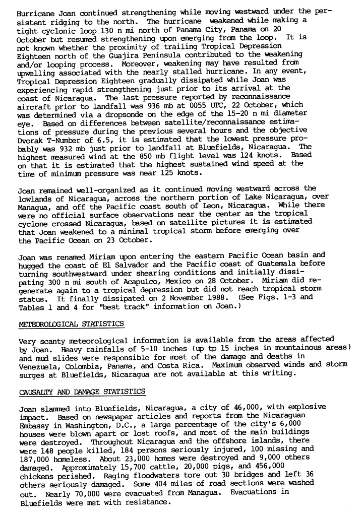
*Some of the systems listed here may be underestimate due to small size. For instance, I would not necessarily keep Joan (1988) at *only* 125 knots. Joan was a very compact, rapidly deepening system as it neared landfall in Nicaragua, much like Ethel (1971), which, despite *only* attaining a minimum recon-derived pressure of 943 mb (which likely was not the lowest pressure, as landfall occurred several hours later, and the storm was rapidly intensifying at the time of the last mission), was likely fully deserving of its Cat-5 designation in HURDAT as it made landfall near Cabo Gracias a Dios, on the Honduras/Nicaragua border. Both Joan and Ethel featured pinhole-type, well-defined eyes on aircraft radar, but the satellite estimates likely did not register the small inner cores. A similar situation actually existed with Felix (2007), whose satellite presentation just before landfall in Nicaragua did *not* support Cat-5 intensity—only a fortuitously timed recon mission hours earlier found that winds in the storm were higher (high-end Cat-4) than satellite indicated, and based on the continued improvement in presentation afterward, the NHC went with 140 knots for the landfall. In all three cases, the highest winds on land affected sparsely populated regions and thus went unrecorded. Based on available data and pre-landfall intensity trends, all three storms likely featured pressures in the low to mid 930s at their peaks/landfalls and similar winds, in the 135-to-145-knot range. My guesses: 135 knots for Joan, 145 knots for Ethel and Felix.
The 1935 Labor Day hurricane, Ethel, Joan, Andrew (1992), Iris (2001), Charley (2004), and Felix, among others, all belong in the same class: tiny, explosively deepening cyclones whose actual intensities were far higher than were/would have been discernible on satellite. Case in point for Joan: the last recon mission into Joan found a pressure of 933 mb hours before landfall over Central America, along with a very small eye. If anything, Joan was probably closer to 135 knots than 125 knots at its peak intensity. As for Andrew, the flight-level winds, pressures, and radar data from both its initial and secondary peaks strongly suggests that 160 knots is probably too low for such a small, explosively deepening, rapidly translating, westward-moving system situated beneath a very strong subtropical ridge and embedded in high environmental pressures. A more realistic estimate for Andrew, in my view, would be 170 knots (with well-documented 922-mb pressures) for both peaks, to the east of the Bahamas and at landfall on South FL. Despite studies, it is by no means conclusive that the extreme wind damage in Naranja Lakes et al., assumed to be from mesovortices in Andrew's eyewall over Dade County, was *entirely* due to mesovortices rather than the representative winds in a very extreme, compact, Cat-5 hurricane. The 1935 hurricane, being even smaller and more intense (892 mb, if not lower) than Andrew, is a very good candidate for Patricia- or Haiyan-league winds—185 to 190 knots at landfall on the FL Keys.
One key note about Andrew: the extreme wind-caused damage swaths were co-located with strong, N-eyewall (hence RMW) convection, suggestive of *potentially* representative winds.
Re: David and Hugo, I concur with your estimate for Hugo, but perhaps not for David. Even visible satellite imagery reveals that David had a very bright, white CDO, extremely impressive, circular outflow, and stadium-effect eye at the time(s) of its likely peak intensity over the northeastern Caribbean Sea. Aircraft-derived surface estimates and measured flight-level winds, while less reliable in the late 1970s vs. today, suggested winds higher than the pressure-wind relationship indicated. David was not a midget-sized storm at the time, but it certainly wasn't a large one, in terms of wind radii. It was pretty similar to Inez (1966) in size. Interestingly, aircraft infamously reported 700-mb winds of 170 knots in the northern eyewall of Inez, concurrent with rapid intensification and a minimum (observed, likely not the deepest) pressure of 927 mb. David and Inez were both similar in terms of overall size, RMW, observed pressure(s), and intensity trend(s) around peak(s); therefore, one may logically deduce that both were similarly intense, with minimum pressures likely in the low 920s and peak sustained winds of 155 to 160 knots. In other words, Irma- and Maria-type winds, but higher pressures because smaller RMWs and wind radii. Another convincing piece of evidence in favour: Inez and David (like Felix at its peak!) were embedded in high environmental pressures. ...
On another note, Hugo is an interesting case to reanalyse, not just for its (probably 150-knot) Cat-5 peak over the MDR, but also for its Cat-4 landfall in SC. Radar data from Charleston, showing a continued tightening of the eye and intensification of lightning/convective activity, suggest that Hugo continued to deepen after the last aircraft mission, while satellite data from the time of landfall (and before) clearly suggested a higher intensity than 120 knots. Even aircraft-derived winds suggest that 120 knots was a cautious estimate. Given evidence of mesovortices in the eye of Hugo, the minimum pressure of 934 mb at landfall is probably a bit high. Finally, while this is inconclusive, the wind damage in the Bulls Bay–McClellanville area was consistent with a much stronger hurricane. All in all, a solid case can be made that Hugo's true intensity at landfall in SC was in the 130-to-135-knot range, with a pressure of 930-932 mb.
Oh, and I also concur with Chris90 re: Lenny being a solid candidate for Cat-5 status, however briefly it attained that plateau.
tatertawt24 wrote:Shell Mound wrote:CrazyC83 wrote:Earlier I took a look at majors up to 1978 (although some may warrant further revision). Now here is my thought for the major hurricanes (either in the best track or that I believe were such) from 1979 to 1994 (i.e. before the most recent era):
1979 - David (BT 150 kt, no change), Frederic (BT 115 kt, no change)
1980 - Allen (BT 165 kt, no change), Frances (BT 100 kt, increase to 125 kt), Ivan (BT 90 kt, increase to 100 kt)
1981 - Harvey (BT 115 kt, no change), Irene (BT 105 kt, no change); REMOVED: Floyd (BT 100 kt, decrease to 85 kt)
1982 - no majors; REMOVED: Debby (BT 115 kt, decrease to 95 kt)
1983 - no majors; REMOVED: Alicia (BT 100 kt, decrease to 90 kt)
1984 - Diana (BT 115 kt, no change)
1985 - Elena (BT 110 kt, no change), Gloria (BT 125 kt, increase to 135 kt), Kate (BT 105 kt, decrease to 100 kt)
1986 - no majors
1987 - Emily (BT 110 kt, increase to 120 kt)
1988 - Gilbert (BT 160 kt, increase to 170 kt), Helene (BT 125 kt, increase to 140 kt), Joan (BT 125 kt, no change)
1989 - Gabrielle (BT 125 kt, no change), Hugo (BT 140 kt, increase to 150 kt)
1990 - Gustav (BT 105 kt, no change)
1991 - Bob (BT 100 kt, increase to 110 kt)
1992 - Andrew (BT 150 kt, increase to 160 kt)
1993 - Emily (BT 100 kt, increase to 110 kt)
1994 - no majors
The biggest increase is with Frances 1980 (best analysis is T6.5, before even reaching 30W longitude!) while Debby is the biggest decrease (no evidence it was higher than T5.0 looking at satellite).
My own tidbits, to be taken for what they are worth:
*Some of the systems listed here may be underestimate due to small size. For instance, I would not necessarily keep Joan (1988) at *only* 125 knots. Joan was a very compact, rapidly deepening system as it neared landfall in Nicaragua, much like Ethel (1971), which, despite *only* attaining a minimum recon-derived pressure of 943 mb (which likely was not the lowest pressure, as landfall occurred several hours later, and the storm was rapidly intensifying at the time of the last mission), was likely fully deserving of its Cat-5 designation in HURDAT as it made landfall near Cabo Gracias a Dios, on the Honduras/Nicaragua border. Both Joan and Ethel featured pinhole-type, well-defined eyes on aircraft radar, but the satellite estimates likely did not register the small inner cores. A similar situation actually existed with Felix (2007), whose satellite presentation just before landfall in Nicaragua did *not* support Cat-5 intensity—only a fortuitously timed recon mission hours earlier found that winds in the storm were higher (high-end Cat-4) than satellite indicated, and based on the continued improvement in presentation afterward, the NHC went with 140 knots for the landfall. In all three cases, the highest winds on land affected sparsely populated regions and thus went unrecorded. Based on available data and pre-landfall intensity trends, all three storms likely featured pressures in the low to mid 930s at their peaks/landfalls and similar winds, in the 135-to-145-knot range. My guesses: 135 knots for Joan, 145 knots for Ethel and Felix.
The 1935 Labor Day hurricane, Ethel, Joan, Andrew (1992), Iris (2001), Charley (2004), and Felix, among others, all belong in the same class: tiny, explosively deepening cyclones whose actual intensities were far higher than were/would have been discernible on satellite. Case in point for Joan: the last recon mission into Joan found a pressure of 933 mb hours before landfall over Central America, along with a very small eye. If anything, Joan was probably closer to 135 knots than 125 knots at its peak intensity. As for Andrew, the flight-level winds, pressures, and radar data from both its initial and secondary peaks strongly suggests that 160 knots is probably too low for such a small, explosively deepening, rapidly translating, westward-moving system situated beneath a very strong subtropical ridge and embedded in high environmental pressures. A more realistic estimate for Andrew, in my view, would be 170 knots (with well-documented 922-mb pressures) for both peaks, to the east of the Bahamas and at landfall on South FL. Despite studies, it is by no means conclusive that the extreme wind damage in Naranja Lakes et al., assumed to be from mesovortices in Andrew's eyewall over Dade County, was *entirely* due to mesovortices rather than the representative winds in a very extreme, compact, Cat-5 hurricane. The 1935 hurricane, being even smaller and more intense (892 mb, if not lower) than Andrew, is a very good candidate for Patricia- or Haiyan-league winds—185 to 190 knots at landfall on the FL Keys.
One key note about Andrew: the extreme wind-caused damage swaths were co-located with strong, N-eyewall (hence RMW) convection, suggestive of *potentially* representative winds.
Re: David and Hugo, I concur with your estimate for Hugo, but perhaps not for David. Even visible satellite imagery reveals that David had a very bright, white CDO, extremely impressive, circular outflow, and stadium-effect eye at the time(s) of its likely peak intensity over the northeastern Caribbean Sea. Aircraft-derived surface estimates and measured flight-level winds, while less reliable in the late 1970s vs. today, suggested winds higher than the pressure-wind relationship indicated. David was not a midget-sized storm at the time, but it certainly wasn't a large one, in terms of wind radii. It was pretty similar to Inez (1966) in size. Interestingly, aircraft infamously reported 700-mb winds of 170 knots in the northern eyewall of Inez, concurrent with rapid intensification and a minimum (observed, likely not the deepest) pressure of 927 mb. David and Inez were both similar in terms of overall size, RMW, observed pressure(s), and intensity trend(s) around peak(s); therefore, one may logically deduce that both were similarly intense, with minimum pressures likely in the low 920s and peak sustained winds of 155 to 160 knots. In other words, Irma- and Maria-type winds, but higher pressures because smaller RMWs and wind radii. Another convincing piece of evidence in favour: Inez and David (like Felix at its peak!) were embedded in high environmental pressures. ...
On another note, Hugo is an interesting case to reanalyse, not just for its (probably 150-knot) Cat-5 peak over the MDR, but also for its Cat-4 landfall in SC. Radar data from Charleston, showing a continued tightening of the eye and intensification of lightning/convective activity, suggest that Hugo continued to deepen after the last aircraft mission, while satellite data from the time of landfall (and before) clearly suggested a higher intensity than 120 knots. Even aircraft-derived winds suggest that 120 knots was a cautious estimate. Given evidence of mesovortices in the eye of Hugo, the minimum pressure of 934 mb at landfall is probably a bit high. Finally, while this is inconclusive, the wind damage in the Bulls Bay–McClellanville area was consistent with a much stronger hurricane. All in all, a solid case can be made that Hugo's true intensity at landfall in SC was in the 130-to-135-knot range, with a pressure of 930-932 mb.
Oh, and I also concur with Chris90 re: Lenny being a solid candidate for Cat-5 status, however briefly it attained that plateau.
Terrific post.
1.) Wasn't Naranja Lakes situated in the southern eyewall of Andrew? Hence the mesovortex explanation for the extreme damage.
2.) Do you have examples of the stronger wind damage from Hugo? Not that I disagree, I'd just really love to see them. And by evidence of mesovortices in the eye, do you mean the satellite imagery?

1900hurricane wrote:Did you know the 888 mb in Gilbert wasn't actually measured? It's actually an estimate based on the 700 mb extrapolated pressure which was then bias corrected. The paper by Willoughby, Masters, and Landsea goes into detail how the value was derived. It's quite an interesting read.

Users browsing this forum: HurricaneFan, Old-TimeCane and 207 guests

_SWA.JPG)