2024 Indicators: SST's, MSLP, Shear, SAL, Steering, Instability (Day 16+ Climate Models)
Moderator: S2k Moderators
Forum rules

The posts in this forum are NOT official forecasts and should not be used as such. They are just the opinion of the poster and may or may not be backed by sound meteorological data. They are NOT endorsed by any professional institution or STORM2K. For official information, please refer to products from the National Hurricane Center and National Weather Service.
-
Category5Kaiju

- Category 5

- Posts: 4345
- Joined: Thu Dec 24, 2020 12:45 pm
- Location: Seattle during the summer, Phoenix during the winter
Re: 2024 Indicators: SST's, MSLP, Shear, SAL, Steering, Instability (Day 16+ Climate Models)
Pretty surreal that we’re looking at the possibility of major landfalls in both the EPAC and the Atlantic basins less than a week apart
6 likes
Unless explicitly stated, all information in my posts is based on my own opinions and observations. Tropical storms and hurricanes can be extremely dangerous. Refer to an accredited weather research agency or meteorologist if you need to make serious decisions regarding an approaching storm.

Re: 2024 Indicators: SST's, MSLP, Shear, SAL, Steering, Instability (Day 16+ Climate Models)
Category5Kaiju wrote:Pretty surreal that we’re looking at the possibility of major landfalls in both the EPAC and the Atlantic basins less than a week apart
Of course very different compared to last year due to the proximity and different location of John and 97L, but it kinda reminds me of Jova and Lee last year. Everyone paid attention to Lee, but it struggled at first while Jova unexpectedly intensified into a cat 5. But then Lee woke up and stole Jova's thunder by becoming an even stronger cat 5. Let's hope this isn't a repeat of last year in terms of intensity.
4 likes
-
WeatherBoy2000
- Category 1

- Posts: 463
- Joined: Mon Apr 10, 2023 9:29 am
Re: 2024 Indicators: SST's, MSLP, Shear, SAL, Steering, Instability (Day 16+ Climate Models)
https://x.com/webberweather/status/1838669456702337233
It's still warming too:

Anomalies are back up over 1.5c and increasing:

Just like last year, the chance for CV cyclones will likely last well into October again.
It's still warming too:
Anomalies are back up over 1.5c and increasing:
Just like last year, the chance for CV cyclones will likely last well into October again.
5 likes
-
weeniepatrol

- Category 5
- Posts: 1345
- Joined: Sat Aug 22, 2020 5:30 pm
- Location: WA State
Re: 2024 Indicators: SST's, MSLP, Shear, SAL, Steering, Instability (Day 16+ Climate Models)
Atlantic SSTs are incomprehensible.

I know you might have to squint to analyze isotherms here. However, the region of 30 C waters in the Atlantic appears to be larger than the region of 30 C waters in the WEST PACIFIC.

I know you might have to squint to analyze isotherms here. However, the region of 30 C waters in the Atlantic appears to be larger than the region of 30 C waters in the WEST PACIFIC.
7 likes
-
Category5Kaiju
- Category 5
- Posts: 4345
- Joined: Thu Dec 24, 2020 12:45 pm
- Location: Seattle during the summer, Phoenix during the winter
Re: 2024 Indicators: SST's, MSLP, Shear, SAL, Steering, Instability (Day 16+ Climate Models)
weeniepatrol wrote:Atlantic SSTs are incomprehensible.
https://i.imgur.com/n889URT.png
I know you might have to squint to analyze isotherms here. However, the region of 30 C waters in the Atlantic appears to be larger than the region of 30 C waters in the WEST PACIFIC.
https://i.imgur.com/mY4R8Q9.png
If that holds and if projected conditions come to fruition, then this season will not only feature the earliest Category 5 on record but also will feature the latest Category 5 on record
7 likes
Unless explicitly stated, all information in my posts is based on my own opinions and observations. Tropical storms and hurricanes can be extremely dangerous. Refer to an accredited weather research agency or meteorologist if you need to make serious decisions regarding an approaching storm.
Re: 2024 Indicators: SST's, MSLP, Shear, SAL, Steering, Instability (Day 16+ Climate Models)
No clue where to put this so I'll put it here. Thought this was a fun little list, the most intense Atlantic hurricane for each letter of the alphabet (so only hurricanes since we've started using official names instead of numbers so no storms like "Labor Day"). The picks are chosen by pressure, but if there is another storm with a higher pressure, but also stronger winds it's added in italics behind it.
A = Allen (1980, 899 mb, 190 mph)
B = Beulah (1967, 921 mb, 160 mph) / Beryl (2024, 934 mb, 165 mph)
C = Camille (1969, 900 mb, 175 mph)
D = Dean (2007, 905 mb, 175 mph) / Dorian (2019, 910 mb, 185 mph)
E = Esther (1961, 919 mb, 160 mph)
F = Felix (2007, 929 mb, 175 mph)
G = Gilbert (1988, 888 mb, 185 mph)
H = Hattie (1961, 914 mb, 165 mph)
I = Ivan (2004, 910 mb, 165 mph) / Irma (2017, 914 mb, 180 mph)
J = Janet (1955, 914 mb, 175 mph)
K = Katrina (2005, 902 mb, 175 mph)
L = Lorenzo (2019, 925 mb, 160 mph) / Lee (2023, 926 mb, 165 mph)
M = Mitch (1998, 905 mb, 180 mph)
N = Nicole (2016, 950 mb, 140 mph)
O = Opal (1995, 916 mb, 150 mph)
P = Paloma (2008, 944 mb, 145 mph)
R = Rita (2005, 895 mb, 180 mph)
S = Sam (2021, 927 mb, 155 mph)
T = Teddy (2020, 945 mb, 140 mph)
V = Vince (2005, 988 mb, 75 mph)
W = Wilma (2005, 882 mb, 185 mph)
8 likes
-
weeniepatrol
- Category 5
- Posts: 1345
- Joined: Sat Aug 22, 2020 5:30 pm
- Location: WA State
Re: 2024 Indicators: SST's, MSLP, Shear, SAL, Steering, Instability (Day 16+ Climate Models)
Well.. it took a while but this season has become uncomfortable again.
9 likes
-
galaxy401

- Category 5
- Posts: 2446
- Age: 30
- Joined: Sat Aug 25, 2012 9:04 pm
- Location: Casa Grande, Arizona
Re: 2024 Indicators: SST's, MSLP, Shear, SAL, Steering, Instability (Day 16+ Climate Models)
This season is likely still going to end above average with hurricanes. We're at 5 hurricanes and could see 3 more within the next week.
3 likes
Got my eyes on moving right into Hurricane Alley: Florida.

Re: 2024 Indicators: SST's, MSLP, Shear, SAL, Steering, Instability (Day 16+ Climate Models)
WiscoWx02 wrote:Teban54 wrote:WiscoWx02 wrote:I think at this point we can agree that the switch is not going to flip. Give it two more weeks now takes us past peak of the season...it isn't a sound argument at this point. The Atlantic is the most hostile anyone has seen since 2013, if not even more hostile because even in 2013 we were able to get named storms at this time. Models light up for a few runs then go poof, and with it being September when conditions don't get more favorable than they do now, it can be reasonably assumed that will not change going forward. Even in 2022 the models were more lively than they are now if I recall correctly.
The experts were right. 2024 would be memorable, but for the opposite reason that they expected. Late June and early July was peak of the season with Beryl. This season has been like a season out of the 1970's shifted forward 2 months haha. Really not much left to say other than that, hard to ignore that something just isn't right with the Atlantic this year and there is a legitimate possibility, if not a probability at this point, that things just aren't going to get going. I think I'm going to check out of watching the tropics the rest of the season, which is going to be weird considering tracking the tropics this time of year has become such an integral part of my yearly routine since 2015. I wonder what 2025 will have in store......?
I remember you said very similar things in 2022 two weeks before Ian happened. Just saying.
I did and ate crow for it I'll admit. Not worried about that this year though. Eric Webb said it all...the writing is on the wall for this season to just not perform.
It's ironic and almost amusing that not only did the original comment age like milk, but it did so in almost the exact same fashion as the same comment from the same user did in 2022.
8 likes
TC naming lists: retirements and intensity
Most aggressive Advisory #1's in North Atlantic (cr. kevin for starting the list)
Most aggressive Advisory #1's in North Atlantic (cr. kevin for starting the list)
-
weeniepatrol
- Category 5
- Posts: 1345
- Joined: Sat Aug 22, 2020 5:30 pm
- Location: WA State
Re: 2024 Indicators: SST's, MSLP, Shear, SAL, Steering, Instability (Day 16+ Climate Models)
At this point it doesn't matter if zero systems form between January and 1 October, you STILL should refrain from canceling and 2013posting. It does NOT matter how hostile you think the Atlantic has been/will be, something WILL find a way to ruin Americans' week.
Honestly this is not even remotely surprising. Almost every single season in the last decade has been comically backloaded.
Case in point. The season is over when it's over and no sooner. Doesn't matter what happens in June, July, August, or even the first half of September.
NO OFFENSE intended to this user!!! I am not trying to single you out nor make this personal. It's just a great example of how easy it is to make.... we'll call them premature posts. I am by zero means innocent of doing this as well!
Honestly this is not even remotely surprising. Almost every single season in the last decade has been comically backloaded.
Teban54 wrote:It's ironic and almost amusing that not only did the original comment age like milk, but it did so in almost the exact same fashion as the same comment from the same user did in 2022
Case in point. The season is over when it's over and no sooner. Doesn't matter what happens in June, July, August, or even the first half of September.
NO OFFENSE intended to this user!!! I am not trying to single you out nor make this personal. It's just a great example of how easy it is to make.... we'll call them premature posts. I am by zero means innocent of doing this as well!
7 likes
-
HurricaneRyan
- Category 3

- Posts: 847
- Age: 32
- Joined: Sun Dec 05, 2010 3:05 pm
Re: 2024 Indicators: SST's, MSLP, Shear, SAL, Steering, Instability (Day 16+ Climate Models)
Helene clearly gave the season cancel posters hell for doubting the season.
7 likes
Kay '22 Hilary '23
-
Keldeo1997
- Category 2

- Posts: 688
- Joined: Fri Oct 11, 2019 11:35 pm
Re: 2024 Indicators: SST's, MSLP, Shear, SAL, Steering, Instability (Day 16+ Climate Models)
Looks like this will be a Quailty over quantity season. Who cares if this is "one of the quietest seasons ever" if everything that does form is very impactful.
2 likes
-
AxaltaRacing24
- Category 5
- Posts: 1774
- Age: 25
- Joined: Wed Jul 27, 2016 11:14 am
- Location: Jupiter, FL
Re: 2024 Indicators: SST's, MSLP, Shear, SAL, Steering, Instability (Day 16+ Climate Models)
Keldeo1997 wrote:Looks like this will be a Quailty over quantity season. Who cares if this is "one of the quietest seasons ever" if everything that does form is very impactful.
I do not think this season is going to end up as "quiet" at this point.
3 likes
-
tolakram
- Admin

- Posts: 20186
- Age: 62
- Joined: Sun Aug 27, 2006 8:23 pm
- Location: Florence, KY (name is Mark)
Re: 2024 Indicators: SST's, MSLP, Shear, SAL, Steering, Instability (Day 16+ Climate Models)
Just remember that this seasons season cancelling was mostly due to the storm COUNT predicted by most organizations. All points valid, this could be a really bad season, but counting is still dumb IMO.
1 likes
M a r k
- - - - -
Join us in chat: Storm2K Chatroom Invite. Android and IOS apps also available.
The posts in this forum are NOT official forecasts and should not be used as such. Posts are NOT endorsed by any professional institution or STORM2K.org. For official information and forecasts, please refer to NHC and NWS products.
Re: 2024 Indicators: SST's, MSLP, Shear, SAL, Steering, Instability (Day 16+ Climate Models)
kevin wrote:Okay I know long-range CFS runs have a value of ~0, but today's 00z run is so crazy that I have to discuss it.
Now that the Atlantic finally seems to notice that it's peak season (at least in about 5 days according to the models), let's take a look at the most recent CFS run combined with our current knowledge of the GEFS & Euro ensembles for fun to see what it thinks of a backloaded season. Once again, the timeframe is so far out that the practical value of one run is ~0, but it's also just a bit for fun. Since it's for fun anyways I also added potential names and rough ACE estimates. Intensity estimates are more based on track and general pressure since CFS basically never gets something below 990 mb.
September
*Sep 20 - Sep 22: Gordon might briefly re-intensify into a TD but nothing more [ACE ~0, season 7/4/1].
*Sep 21 - Sep 23: A weak TS could form west of Gordon, becoming Helene [ACE 0 - 2, season 8/4/1].
*Sep 24 - Oct 2: The WCar disturbance forms, Isaac. CFS is notoriously bad with Yucatan-related stuff so it becomes a strung out mess. Let's for now use the GEFS and Euro ensembles, assuming a MH making landfall somewhere along the US coast [ACE 15 - 25, season 9/5/2].
*Sep 24 - Sep 29: Around the same time the eastern MDR disturbance forms, potentially stealing the WCar's I-name. For now I put it as Joyce. Recurves quite early on the CFS run. Based on current ensembles probably a recurving hurricane. Let's for now assume a middle-of-the-road case and not the massive MH GFS shows [ACE 10 - 20, season 10/6/2].
*Sep 25 - Sep 28: A STS forms east of the US, Kirk. This one is also showing up in the GEFS ensembles. CFS even seems to make it a low-end hurricane (pressure in the high 980s, which is very low for CFS) before becoming extra-tropical. No threat to land [ACE 5 - 10, season 11/7/2].
*Sep 26 - Oct 6: Another TD/TS forms below Joyce in the lower portion of the MDR, becoming Leslie. This is in-line with some GEFS members which show more MDR action near the end of the ensemble run. Makes landfall in the Lesser Antilles and the Bahamas and then recurves away. Based on track probably a hurricane [ACE 10 - 20, season 12/8/2].
*Sep 27 - Oct 6: Ehm... there's another MDR storm coming from Africa, becoming Milton. Recurves before the Lesser Antilles and dissipates while recurving. Based on track probably a hurricane. For statistics sake, let's assume that either Joyce, Leslie or Milton becomes a MH [ACE 10 - 20, season 13/9/3].
October
*Oct 8 - Oct 15: The Atlantic needs a day or two to recover, but then we get another eastern MDR storm, Nadine. Recurves OTS early, but probably a hurricane based on track [ACE 5 - 15, season 14/10/3].
*Oct 16 - Oct 24: For the first time this year a CFS run which shows long-range TC genesis in the WCar, Oscar. Stays around for quite some days in the boiling WCar and then goes to Cuba/Florida and also impacts the NY region afterwards while turning extra-tropical. Late-season WCar storm makes me go with a MH [ACE 15 - 25, season 15/11/4].
*Oct 17 - 24: A TS forms in the central Atlantic, Patty. Recurves far east, but the low pressure in the 990s for the MDR makes me go with a recurving hurricane. Eventually dissipates west of Spain [ACE 5 - 15, season 16/12/4].
*Oct 20 - 26. A STS forms off the coast of the US, Rafael. Stays around for a few days and moves east, intensifying into probably a high-end TS or low-end hurricane before dissipating. Let's assume a TS for now just to compensate for some of the craziness of this run [ACE 5 - 10, season 17/12/4].
*Oct 31 - Nov 2: Short-lived STS OTS, Sara [ACE 0 - 2, season 18/12/4].
November
*Nov 4 - 8: A STS forms east of the US and intensifies into a strong hurricane, Tony, potentially a MH before impacting NY and Newfoundland. Almost Sandy-like [ACE 10 - 15, season 19/13/5].
*Nov 19 - 24. A huge STS forms in the central Atlantic, Valerie. Intensifies into the 960s mbar, which is unheard of for a large-scale model like CFS. Eventually becomes extra-tropical, but no clue what to make of this. Put it as a hurricane for now [ACE 10 - 15, season 20/14/5].
Conclusion
This has to be the craziest CFS run I've ever seen and would put 2020's late season to shame. Combining this with the season so far would result in season totals of 20/14/5 and an ACE in the range of 160 - 250. Also, somehow the model churns out 6 more TCs in the last 11 days of this month. Does this mean this will become reality? No, of course not. Let's first see whether the relatively short-term prediction of a crazy end of September comes to fruition. But, if CFS is correctly sniffing out late-season favorability, we could be in for quite a ride.
Now a little more than a week later let's see where we stand. We are now at Isaac and will most likely have Joyce within an hour. If models are to be believed, the wave behind Joyce will form into a TC around the end of the month so I think realistically Joyce and Kirk is the most we can get before October. The WCar disturbance will most likely form a little later in the first week of October. So we may not get to the 'M' storm in September, but CFS still correctly saw the increased favorability for TC genesis. And based on the long-term ECMWF favorability for the first half of October the season might still catch up with this CFS run within that timespan. Interestingly, while it may just be a coincidence, the storm labeled as 'Kirk' in this post actually formed in about the same place and timespan as Isaac in reality. And the CFS Leslie/Milton both sound very similar both in time span and location to the wave behind 98L.
2 likes
-
tolakram
- Admin
- Posts: 20186
- Age: 62
- Joined: Sun Aug 27, 2006 8:23 pm
- Location: Florence, KY (name is Mark)
Re: 2024 Indicators: SST's, MSLP, Shear, SAL, Steering, Instability (Day 16+ Climate Models)
I'll put this saved sat loop here as well. Sept 27th, morning after Cat 4 Helene made landfall. Clockwise, Helene, Isaac, Joyce.

6 likes
M a r k
- - - - -
Join us in chat: Storm2K Chatroom Invite. Android and IOS apps also available.
The posts in this forum are NOT official forecasts and should not be used as such. Posts are NOT endorsed by any professional institution or STORM2K.org. For official information and forecasts, please refer to NHC and NWS products.
- - - - -
Join us in chat: Storm2K Chatroom Invite. Android and IOS apps also available.
The posts in this forum are NOT official forecasts and should not be used as such. Posts are NOT endorsed by any professional institution or STORM2K.org. For official information and forecasts, please refer to NHC and NWS products.
-
WeatherBoy2000
- Category 1
- Posts: 463
- Joined: Mon Apr 10, 2023 9:29 am
Re: 2024 Indicators: SST's, MSLP, Shear, SAL, Steering, Instability (Day 16+ Climate Models)
The activity within the past couple days has got the named storm count metrics back to average:
https://tropical.atmos.colostate.edu/Realtime/ (we're at 10 storms now with Joyce).
Depending on how the next couple weeks turn out, the Atlantic may ease its way back to above average.
https://tropical.atmos.colostate.edu/Realtime/ (we're at 10 storms now with Joyce).
Depending on how the next couple weeks turn out, the Atlantic may ease its way back to above average.
1 likes
-
Category5Kaiju
- Category 5
- Posts: 4345
- Joined: Thu Dec 24, 2020 12:45 pm
- Location: Seattle during the summer, Phoenix during the winter
Re: 2024 Indicators: SST's, MSLP, Shear, SAL, Steering, Instability (Day 16+ Climate Models)
tolakram wrote:I'll put this saved sat loop here as well. Sept 27th, morning after Cat 4 Helene made landfall. Clockwise, Helene, Isaac, Joyce.
https://i.imgur.com/a2Y3MEn.gif
Dang, Helene is GIGANTIC compared to those other systems.
2 likes
Unless explicitly stated, all information in my posts is based on my own opinions and observations. Tropical storms and hurricanes can be extremely dangerous. Refer to an accredited weather research agency or meteorologist if you need to make serious decisions regarding an approaching storm.
Re: 2024 Indicators: SST's, MSLP, Shear, SAL, Steering, Instability (Day 16+ Climate Models)
Is September 27 the new September 10?
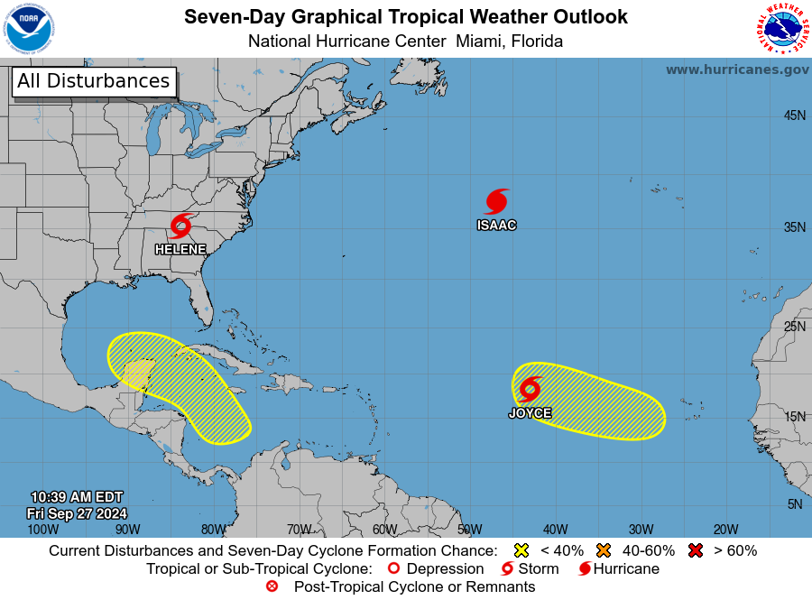
- Helene is still causing flooding problems after an impressive Cat 4 landfall
- Isaac strengthened into a high-latitude hurricane, and may even have a chance at Cat 2 (however small)
- Joyce has formed, marking the first time in 2024 with three concurrent TCs
- Two more lemons, with a possible Helene redux and a possible MDR storm in October
1 likes
TC naming lists: retirements and intensity
Most aggressive Advisory #1's in North Atlantic (cr. kevin for starting the list)
Most aggressive Advisory #1's in North Atlantic (cr. kevin for starting the list)
Re: 2024 Indicators: SST's, MSLP, Shear, SAL, Steering, Instability (Day 16+ Climate Models)
Category5Kaiju wrote:tolakram wrote:I'll put this saved sat loop here as well. Sept 27th, morning after Cat 4 Helene made landfall. Clockwise, Helene, Isaac, Joyce.
https://i.imgur.com/a2Y3MEn.gif
Dang, Helene is GIGANTIC compared to those other systems.
Big cyclone for sure.....similar in size to Allen or Gilbert?...
0 likes
Who is online
Users browsing this forum: No registered users and 233 guests