Can we not do this for a third time please
2024 Global Model Runs Discussion (Out thru day 16)
Moderator: S2k Moderators
Forum rules

The posts in this forum are NOT official forecasts and should not be used as such. They are just the opinion of the poster and may or may not be backed by sound meteorological data. They are NOT endorsed by any professional institution or STORM2K. For official information, please refer to products from the National Hurricane Center and National Weather Service.
-
WaveBreaking

- Category 2

- Posts: 728
- Joined: Sun Jun 30, 2024 11:33 am
- Location: US
Re: 2024 Global Model Runs Discussion (Out thru day 16)
Can we not do this for a third time please
2 likes
I am NOT a professional meteorologist, so take all of my posts with a grain of salt. My opinions are mine and mine alone.
-
floridasun
- Tropical Storm

- Posts: 245
- Joined: Tue Sep 14, 2021 3:59 pm
Re: 2024 Global Model Runs Discussion (Out thru day 16)
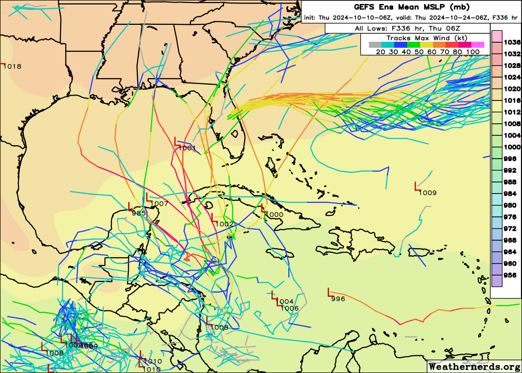
gfs only one support system in nw carribbean now need more support before their put it on outlookTeban54 wrote:6z GEFS has a few more members showing a strong hurricane crossing near the Yucatan Channel.
Please, can we just don't?
https://i.postimg.cc/L5V35HLy/gefs-2024-10-10-06-Z-336-36-788-260-804-9-343-301-634-MSLP-Surface-tracks-lows.png
1 likes
-
jlauderdal
- S2K Supporter

- Posts: 7240
- Joined: Wed May 19, 2004 5:46 am
- Location: NE Fort Lauderdale
- Contact:
-
SFLcane

- S2K Supporter
- Posts: 10281
- Age: 48
- Joined: Sat Jun 05, 2010 1:44 pm
- Location: Lake Worth Florida
Re: 2024 Global Model Runs Discussion (Out thru day 16)
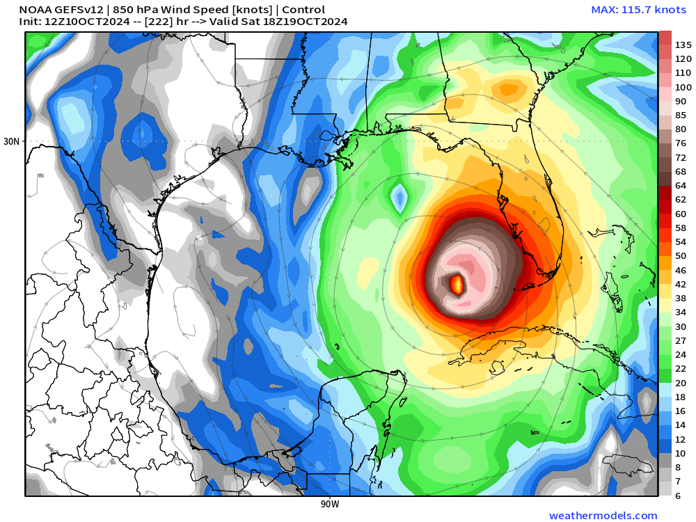
jlauderdal wrote:Bernie speaks and he has been good.
https://x.com/AccuRayno/status/1844409625086656515
https://x.com/AccuRayno/status/1844409625086656515
1 likes
-
Weathertracker96
- Tropical Storm
- Posts: 150
- Joined: Mon Oct 16, 2023 3:41 pm
Re: 2024 Global Model Runs Discussion (Out thru day 16)
SFLcane wrote:jlauderdal wrote:Bernie speaks and he has been good.
https://x.com/AccuRayno/status/1844409625086656515
https://x.com/AccuRayno/status/1844409625086656515
Would the high push anything down there into Central America ?
0 likes
-
Meteorcane

- Category 2
- Posts: 559
- Joined: Thu Jul 21, 2011 6:49 am
- Location: North Platte Nebraska
Re: 2024 Global Model Runs Discussion (Out thru day 16)
Weathertracker96 wrote:
Would the high push anything down there into Central America ?
Initially yes, anything would probably have a mostly westward component... but this time of year the pattern tends to be pretty progressive and ridges can break down relatively quickly. Another factor would be exactly how far north anything would form in the W.Carribbean, the further south the more likely it would get buried in Central America, whereas the further north it forms, the more likely it could feel a weakness and be drawn northward
3 likes
-
Category5Kaiju

- Category 5

- Posts: 4346
- Joined: Thu Dec 24, 2020 12:45 pm
- Location: Seattle during the summer, Phoenix during the winter
Re: 2024 Global Model Runs Discussion (Out thru day 16)
“How many more storms do you want to menace Tampa”
2024: “Yes.”
12 likes
Unless explicitly stated, all information in my posts is based on my own opinions and observations. Tropical storms and hurricanes can be extremely dangerous. Refer to an accredited weather research agency or meteorologist if you need to make serious decisions regarding an approaching storm.

Re: 2024 Global Model Runs Discussion (Out thru day 16)
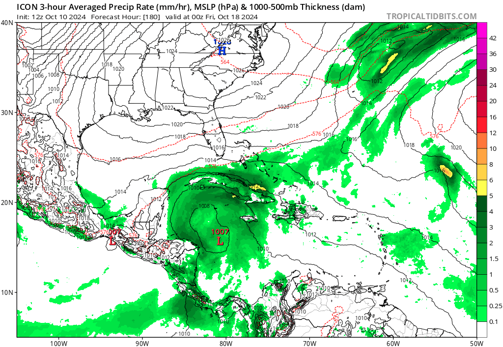
The fact that we may be facing another one is insane. ICON, GFS and it's ensembles supporting the idea does lend more credibility. CMC and Euro ensembles show a slight tick up in the region as well.SFLcane wrote:12z GEFS control...

6 likes
-
floridasun
- Tropical Storm
- Posts: 245
- Joined: Tue Sep 14, 2021 3:59 pm
Re: 2024 Global Model Runs Discussion (Out thru day 16)
gfs of tropical tidbit dont show that show it going to northern gulf from middle of gulfWoofde wrote:The fact that we may be facing another one is insane. ICON, GFS and it's ensembles supporting the idea does lend more credibility. CMC and Euro ensembles show a slight tick up in the region as well.
0 likes


Re: 2024 Global Model Runs Discussion (Out thru day 16)
Regardless of eventual timing, landfall location, or intensity; It would appear things are favorable for tropical development in the NW Caribbean
4 likes
-
Weathertracker96
- Tropical Storm
- Posts: 150
- Joined: Mon Oct 16, 2023 3:41 pm
Re: 2024 Global Model Runs Discussion (Out thru day 16)
Meteorcane wrote:Weathertracker96 wrote:
Would the high push anything down there into Central America ?
Initially yes, anything would probably have a mostly westward component... but this time of year the pattern tends to be pretty progressive and ridges can break down relatively quickly. Another factor would be exactly how far north anything would form in the W.Carribbean, the further south the more likely it would get buried in Central America, whereas the further north it forms, the more likely it could feel a weakness and be drawn northward
Thanks for answering. After seeing the GEFS control, I guess this is else to watch now. Milton caused flooding & damage in my area. Will be watching the model trends. Won’t be surprised if we get another lemon down there this weekend sigh..
1 likes


Re: 2024 Global Model Runs Discussion (Out thru day 16)
Woofde wrote:The fact that we may be facing another one is insane. ICON, GFS and it's ensembles supporting the idea does lend more credibility. CMC and Euro ensembles show a slight tick up in the region as well.
I just sighed
3 likes
Hurricane Experience: Charley 2004, Frances 2004, Jeanne 2004, Matthew 2016, Irma 2017, Dorian 2019, Ian 2022, Nicole 2022, Helene 2024, Milton 2024
-
floridasun
- Tropical Storm
- Posts: 245
- Joined: Tue Sep 14, 2021 3:59 pm
Re: 2024 Global Model Runs Discussion (Out thru day 16)
this part season that florida watch carribbean we all remember wilma other came from that area in oct
2 likes

Re: 2024 Global Model Runs Discussion (Out thru day 16)
I just can't. My tree guy just left and will be back in a couple of days to take care of Milton's mess, and it's a large one. My trees can't take anymore. (nor my nerves)
I'll just leave the boards on the front porch for a while. Geez! 2004 redux west coast edition.
I'll just leave the boards on the front porch for a while. Geez!
2004 redux west coast edition.
3 likes

Re: 2024 Global Model Runs Discussion (Out thru day 16)
GFS has been hinting at a W Caribbean system ever since Milton formed. Doesn't seem like a phantom now that other Globals are starting to jump onboard. There has already been WAY too much sensationalism on social media about future Nadine hitting Florida. Way too early for all that.
6 likes
Igor 2010, Sandy 2012, Fay 2014, Gonzalo 2014, Joaquin 2015, Nicole 2016, Humberto 2019, Imelda 2025
I am only a tropical weather enthusiast. My predictions are not official and may or may not be backed by sound meteorological data. For official information, please refer to the NHC and NWS products.
I am only a tropical weather enthusiast. My predictions are not official and may or may not be backed by sound meteorological data. For official information, please refer to the NHC and NWS products.
-
weeniepatrol

- Category 5
- Posts: 1345
- Joined: Sat Aug 22, 2020 5:30 pm
- Location: WA State
-
wzrgirl1

- S2K Supporter
- Posts: 1360
- Joined: Sat Sep 04, 2004 6:44 am
- Location: Pembroke Pines, Florida
Re: 2024 Global Model Runs Discussion (Out thru day 16)
https://moe.met.fsu.edu/cgi-bin/gfstc2. ... =Animation
Click Fwd. to advance it. Goes out to October 17-18th.
Click Fwd. to advance it. Goes out to October 17-18th.
Last edited by wzrgirl1 on Thu Oct 10, 2024 5:59 pm, edited 1 time in total.
1 likes
Who is online
Users browsing this forum: Cdenton12 and 127 guests