Possible development in the Gulf of Mexico (Is Invest 92L)

This is the general tropical discussion area. Anyone can take their shot at predicting a storms path.

Moderator: S2k Moderators

Forum rules

The posts in this forum are NOT official forecasts and should not be used as such. They are just the opinion of the poster and may or may not be backed by sound meteorological data. They are NOT endorsed by any professional institution or STORM2K. For official information, please refer to products from the National Hurricane Center and National Weather Service.

Help Support Storm2K
Message
Author
BIFF_THE_UNRULY
Tropical Storm
Tropical Storm
Posts: 143
Joined: Fri Jun 28, 2024 2:12 pm

Re: Possible development in the Western Caribbean (0/50)

#221 Postby BIFF_THE_UNRULY » Sun Sep 29, 2024 8:22 pm

eastcoastFL wrote:
BIFF_THE_UNRULY wrote:
ConvergenceZone wrote:
Yea I do think Florida can get some rains from this. Let's just hope the rains move in and out fairly quickly if they do come. They need a break.


Would tend to disagree. Helene was a very poor rainmaker for us. We probably need more rain.


I guess that would depend on where exactly you are located.


Helene did not put much Rain in Florida. It gave issues to Georgia and the Carolinas, but it moved way too fast for most of our state. Barring the direct impact area's I dont think rain was all that significant of a factor for Florida.
2 likes   

BIFF_THE_UNRULY
Tropical Storm
Tropical Storm
Posts: 143
Joined: Fri Jun 28, 2024 2:12 pm

Re: Possible development in the Western Caribbean (0/50)

#222 Postby BIFF_THE_UNRULY » Sun Sep 29, 2024 8:24 pm

In fact Helene was the Driest dang storm i was ever in. we did not get any rain until well into the night

It was hot, dusty, dry and miserable wind for the first 6 hours. Really unlike anything i have ever associated with a tropical system and I was on the Dirty side in Hudson Florida. Precipitation was over us on radar but it just never made it down
3 likes   

User avatar
ScottNAtlanta
Category 5
Category 5
Posts: 2367
Joined: Sat May 25, 2013 3:11 pm
Location: Atlanta, GA

Re: Possible development in the Western Caribbean (0/50)

#223 Postby ScottNAtlanta » Sun Sep 29, 2024 8:32 pm

HurricaneBelle wrote:
psyclone wrote:There's a pretty good signal for heavy rain over Florida at a minimum. Anything beyond that fits into the unknowable category at this point. I'd disregard both the hype squad and the professional downcast squad at this point and wait for clarity...which will take awhile...pretty much just like every potential system.


Speaking of rains, interestingly we didn't get very much from Helene in Pinellas (I recorded about 1.5 inch total at my house from Wed night-Fri AM) so for those of us not subject to surge Debby was worse (had some water intrusion myself). Of course Helene was catastrophic for those who were, and I'd rather have the water intrusion I dealt with than for all those people to suffer on the coast.

For this one I could do without the rain and the surge.

I got 12.5 inches at my house in Atlanta...I can definitely say I do not want another storm coming this way for the rest of the season.
4 likes   
The posts in this forum are NOT official forecast and should not be used as such. They are just the opinion of the poster and may or may not be backed by sound meteorological data. They are NOT endorsed by any professional institution or storm2k.org. For official information, please refer to the NHC and NWS products.

User avatar
wzrgirl1
S2K Supporter
S2K Supporter
Posts: 1325
Joined: Sat Sep 04, 2004 6:44 am
Location: Pembroke Pines, Florida

Re: Possible development in the Western Caribbean (0/50)

#224 Postby wzrgirl1 » Sun Sep 29, 2024 8:38 pm

0 likes   

User avatar
wzrgirl1
S2K Supporter
S2K Supporter
Posts: 1325
Joined: Sat Sep 04, 2004 6:44 am
Location: Pembroke Pines, Florida

Re: Possible development in the Western Caribbean (0/50)

#225 Postby wzrgirl1 » Sun Sep 29, 2024 8:41 pm

0 likes   

O Town
S2K Supporter
S2K Supporter
Posts: 5205
Age: 52
Joined: Wed Sep 07, 2005 9:37 pm
Location: Orlando, Florida 28°35'35"N 81°22'55"W

Re: Possible development in the Western Caribbean (0/50)

#226 Postby O Town » Sun Sep 29, 2024 8:41 pm

gatorcane wrote:The GFS has a much different track than previous runs. How this doesn't become stronger than just a TS though:

https://i.postimg.cc/Pq8WjhM9/floop-gfs-2024092918-sfcwind-mslp-caribbean.gif

Not a fan of how it seems to linger on the west coast for 24hrs or more. Even if it’s just an undeveloped low and and just brings rain….
1 likes   

#ORLANDOSTRONG

User avatar
eastcoastFL
Category 5
Category 5
Posts: 3901
Age: 43
Joined: Thu Apr 12, 2007 12:29 pm
Location: Palm City, FL

Re: Possible development in the Western Caribbean (0/50)

#227 Postby eastcoastFL » Sun Sep 29, 2024 8:42 pm

BIFF_THE_UNRULY wrote:In fact Helene was the Driest dang storm i was ever in. we did not get any rain until well into the night

It was hot, dusty, dry and miserable wind for the first 6 hours. Really unlike anything i have ever associated with a tropical system and I was on the Dirty side in Hudson Florida. Precipitation was over us on radar but it just never made it down


Again, that depends on your specific location. There were places in the panhandle that had over a foot of rain. Here in Stuart we had a few heavy bands come through but not more than an inch of rain. But you also have a lot of places still saturated from the surge all up and down some of our gulf coast. They don’t need anymore rain.
0 likes   
Personal Forecast Disclaimer:
The posts in this forum are NOT official forecast and should not be used as such. They are just the opinion of the poster and may or may not be backed by sound meteorological data. They are NOT endorsed by any professional institution or storm2k.org. For official information, please refer to the NHC and NWS products.

LARanger
Tropical Storm
Tropical Storm
Posts: 131
Joined: Wed Oct 07, 2020 12:45 pm

Re: Possible development in the Western Caribbean (0/50)

#228 Postby LARanger » Sun Sep 29, 2024 9:25 pm

Frank P wrote:GFS 12z model run says what cold front? More GFS shenanigans me thinks!
https://i.ibb.co/YZJ84bn/floop-gfs-2024092912-sfcwind-mslp-gom.gif


Did that just "lol j/k" at Florida then smack New Orleans?
0 likes   
Baton Rouge area cyclone dilettante, PSWAGGER* tropical weather & hydrology model developer
(* Pseudo-Scientific Wild-A** Guesses Generally Expressed Ridiculously)
The GFDL would've had all this figured out by now.

hipshot
Category 2
Category 2
Posts: 591
Joined: Tue Jul 06, 2010 9:18 pm
Location: Dallas, Texas

Re: Possible development in the Western Caribbean (0/50)

#229 Postby hipshot » Sun Sep 29, 2024 9:35 pm

LARanger wrote:
Frank P wrote:GFS 12z model run says what cold front? More GFS shenanigans me thinks!
https://i.ibb.co/YZJ84bn/floop-gfs-2024092912-sfcwind-mslp-gom.gif


Did that just "lol j/k" at Florida then smack New Orleans?

That's what it looked like on that run. It looked like a low also hit the Houston area before that.
0 likes   

User avatar
Blown Away
S2K Supporter
S2K Supporter
Posts: 10145
Joined: Wed May 26, 2004 6:17 am

Re: Possible development in the Western Caribbean (0/50)

#230 Postby Blown Away » Sun Sep 29, 2024 9:57 pm

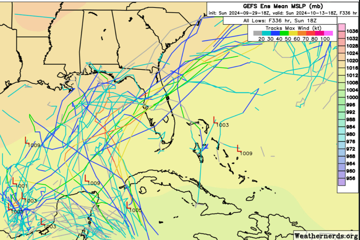
Image
18z GEFS…

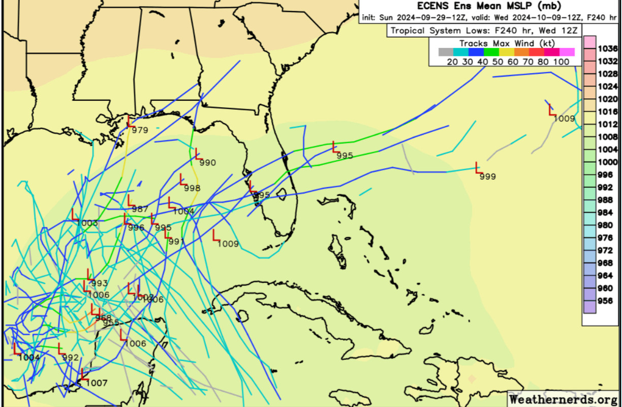
Image
12z ECENS…
1 likes   
Hurricane Eye Experience: David 79, Irene 99, Frances 04, Jeanne 04, Wilma 05... EYE COMING MY WAY IN 2024…
Hurricane Brush Experience: Andrew 92, Erin 95, Floyd 99, Matthew 16, Irma 17, Ian 22, Nicole 22…

User avatar
cycloneye
Admin
Admin
Posts: 145295
Age: 68
Joined: Thu Oct 10, 2002 10:54 am
Location: San Juan, Puerto Rico

Re: Possible development in the Western Caribbean (0/50)

#231 Postby cycloneye » Mon Sep 30, 2024 1:04 am

Western Caribbean Sea and Gulf of Mexico:
A broad area of low pressure located over the western Caribbean Sea
is producing disorganized showers and thunderstorms. Environmental
conditions appear to be conducive for gradual development, and a
tropical depression could form around the middle part of this week
while the disturbance moves slowly west-northwestward. This system
is then expected to move northwestward into the Gulf of Mexico
during the latter portion of this week. Interests in the
northwestern Caribbean Sea and along the U.S. Gulf Coast should
monitor the progress of this system.
* Formation chance through 48 hours...low...near 0 percent.
* Formation chance through 7 days...medium...50 percent.
0 likes   
Visit the Caribbean-Central America Weather Thread where you can find at first post web cams,radars
and observations from Caribbean basin members Click Here

otowntiger
Category 5
Category 5
Posts: 1921
Joined: Tue Aug 31, 2004 7:06 pm

Re: Possible development in the Western Caribbean (0/50)

#232 Postby otowntiger » Mon Sep 30, 2024 5:49 am

It looks like the GFS, CMC and the Euro all take a system from the general area of the BOC across the gulf and over the FL peninsula by Monday/Tuesday next week- ranging from a weak TD to Cat 1 cane. Decent agreement for now. ICON forms a storm in the BOC and has it drifting slowly north and that’s where it ends since it only goes out 120 hours.

:edit: my comments above based on the overnight (12z) runs - of course since then the GFS pivots to bring a low pressure center to the northern gulf coast after it looked like it was on to a little consistency, lol. (See runs posted by Ivsnhater below)
Last edited by otowntiger on Mon Sep 30, 2024 6:34 am, edited 3 times in total.
0 likes   

User avatar
Ivanhater
Storm2k Moderator
Storm2k Moderator
Posts: 11160
Age: 38
Joined: Fri Jul 01, 2005 8:25 am
Location: Pensacola

Re: Possible development in the Western Caribbean (0/50)

#233 Postby Ivanhater » Mon Sep 30, 2024 5:50 am

Solid western shift in this mornings models

ImageImage

Sent from my motorola razr plus 2023 using Tapatalk
1 likes   
Michael

Frank P
S2K Supporter
S2K Supporter
Posts: 2776
Joined: Fri Aug 29, 2003 10:52 am
Location: Biloxi Beach, Ms
Contact:

Re: Possible development in the Western Caribbean / GOM (0/50)

#234 Postby Frank P » Mon Sep 30, 2024 6:18 am

06z GFS run showing multiple lows
Image
1 likes   

Frank P
S2K Supporter
S2K Supporter
Posts: 2776
Joined: Fri Aug 29, 2003 10:52 am
Location: Biloxi Beach, Ms
Contact:

Re: Possible development in the Western Caribbean / GOM (0/50)

#235 Postby Frank P » Mon Sep 30, 2024 6:23 am

06z ICON overall set up is similar to the Oz and would most likely track it east over the GOM towards the west coast of FL.
0 likes   

User avatar
GCANE
S2K Supporter
S2K Supporter
Posts: 11496
Joined: Mon Oct 22, 2007 8:03 am

Re: Possible development in the Western Caribbean / GOM (0/50)

#236 Postby GCANE » Mon Sep 30, 2024 6:24 am

It appears GFS and ICON are onto a 700mb vort that develops just offshore of Mexico in the EPAC.
It crosses the IoT and spins up in the BoC.
Lots of high CAPE and TPW being fed into it from the EPAC and W Carib.
Will be in a small ARWB generated by a trof over TX.
Good setup.
0 likes   

Frank P
S2K Supporter
S2K Supporter
Posts: 2776
Joined: Fri Aug 29, 2003 10:52 am
Location: Biloxi Beach, Ms
Contact:

Re: Possible development in the Western Caribbean / GOM (0/50)

#237 Postby Frank P » Mon Sep 30, 2024 6:30 am

CMC similar to the EURO with a weak system to the west coast of FL but has a new system in the S GOM 10 days out.
Image
1 likes   

User avatar
cycloneye
Admin
Admin
Posts: 145295
Age: 68
Joined: Thu Oct 10, 2002 10:54 am
Location: San Juan, Puerto Rico

Re: Possible development in the Western Caribbean / GOM (0/40)

#238 Postby cycloneye » Mon Sep 30, 2024 6:56 am

Important change of the timing at 8 AM TWO:

Western Caribbean Sea and Gulf of Mexico:
A large and disorganized area of low pressure located over the
western and southwestern Caribbean Sea is producing some shower and
thunderstorm activity. Environmental conditions could become
conducive for gradual development, and a tropical depression could
form in a few days while the system is over the southern Gulf of
Mexico or northwestern Caribbean Sea. While interests in the
northwestern Caribbean Sea and along the U.S. Gulf Coast should
continue to monitor the progress of this system, the timetable for
potential development has shifted later toward late week or this
weekend.
* Formation chance through 48 hours...low...near 0 percent.
* Formation chance through 7 days...medium...40 percent.


Image
0 likes   
Visit the Caribbean-Central America Weather Thread where you can find at first post web cams,radars
and observations from Caribbean basin members Click Here

Michele B
S2K Supporter
S2K Supporter
Posts: 1114
Joined: Thu Aug 25, 2016 8:08 am
Location: SWFL

Re: Possible development in the Western Caribbean (0/50)

#239 Postby Michele B » Mon Sep 30, 2024 7:02 am

BIFF_THE_UNRULY wrote:In fact Helene was the Driest dang storm i was ever in. we did not get any rain until well into the night

It was hot, dusty, dry and miserable wind for the first 6 hours. Really unlike anything i have ever associated with a tropical system and I was on the Dirty side in Hudson Florida. Precipitation was over us on radar but it just never made it down


Other things were weird to me, too.

Usually, as a hurricane passes by, the temps drop somewhat. Yes, plenty of humidity, but the temperatures do go down - even if it's just a few degrees. It didn't seem like that happened.

It stayed very warm throughout and just "felt" different.
0 likes   
Cleo - 1964, Betsy - 1965, David - 1979, Andrew - 1992, Charlie (Francis, Ivan, Jeanne) - 2004, Irma - 2017, Ian - 2022

User avatar
Teban54
Category 5
Category 5
Posts: 3204
Joined: Sat May 19, 2018 1:19 pm

Re: Possible development in the Western Caribbean (0/50)

#240 Postby Teban54 » Mon Sep 30, 2024 7:16 am

Hammy wrote:
MetroMike wrote:
Teban54 wrote:IIRC several ensemble runs for Helene, especially EPS, didn't start showing anything stronger than Cat 1 until about 3-5 days before genesis. Operational Euro didn't even develop it, which led people into thinking the best analog was Karen 2013, or a PTC that never becomes a TC before landfall.


I don’t understand the correlation of Karen 2013 to this hurricane. Anymore insight?


Some posts were making comparisons between future-Helene and Karen, and seemingly treating the models that failed to develop it/briefly developed it as set in stone.

Here are examples from two different users 3 days before Helene formed. (Not saying this system will experience the same.)
On September 20, someone wrote:Best analog here would be KAREN 2013 if these trends continue. Note the "if". However, the EPAC may receive TWO significant hurricanes instead, both of which could be threats to Mexico.

On September 20, someone wrote:I disagree, I think there's a distinct possibility the CAG storm doesn't become more than a moderate TS (think Karen in 2013). Not much support for the MDR systems. Not going much beyond 70 ACE is a possibility, especially if there's a 2013 like shutdown in October.
2 likes   


Return to “Talkin' Tropics”

Who is online

Users browsing this forum: gib, Hurricane2022, HurricaneFan, RomP and 49 guests