Near Yucatán / SE Gulf of Mexico development (Is Invest 91L)
Moderator: S2k Moderators
Forum rules
The posts in this forum are NOT official forecasts and should not be used as such. They are just the opinion of the poster and may or may not be backed by sound meteorological data. They are NOT endorsed by any professional institution or STORM2K. For official information, please refer to products from the National Hurricane Center and National Weather Service.
Re: Near Yucatán / SE Gulf of Mexico development
According to the GFS and Euro it will turn very stormy across the NW Caribbean waters starting tomorrow morning through Thursday while both vortices possibly consolidate over or near the Yucatan P.
Shear keeps the deepest convection to the east of it, typical early system.
3 likes
- cycloneye
- Admin
- Posts: 139596
- Age: 67
- Joined: Thu Oct 10, 2002 10:54 am
- Location: San Juan, Puerto Rico
Re: Near Yucatán / SE Gulf of Mexico development
Tropical Weather Outlook
NWS National Hurricane Center Miami FL
800 PM EDT Tue May 31 2022
For the North Atlantic...Caribbean Sea and the Gulf of Mexico:
Near the Yucatan Peninsula and Southeastern Gulf of Mexico:
A large area of disturbed weather has developed near the Yucatan
Peninsula, partially related to the remnants of Agatha interacting
with an upper-level trough over the Gulf of Mexico. Despite this
marginal environment, this system is likely to become a tropical
depression by Friday as it moves northeastward across the Yucatan
Peninsula, the northwestern Caribbean Sea, and southeastern Gulf of
Mexico. Regardless of development, locally heavy rainfall is likely
across portions of southeastern Mexico, the Yucatan Peninsula,
Guatemala, and Belize during the next couple of days, spreading
across western Cuba, southern Florida, and the Florida Keys on
Friday and Saturday. Interests in the Yucatan Peninsula, western
Cuba, the Florida Keys and the Florida Peninsula should monitor the
progress of this system.
* Formation chance through 48 hours...medium...40 percent.
* Formation chance through 5 days...high...70 percent.
$$
Forecaster Papin
0 likes
Visit the Caribbean-Central America Weather Thread where you can find at first post web cams,radars
and observations from Caribbean basin members Click Here
- Iceresistance
- Category 5
- Posts: 8931
- Age: 20
- Joined: Sat Oct 10, 2020 9:45 am
- Location: Tecumseh, OK/Norman, OK
Re: Near Yucatán / SE Gulf of Mexico development
cycloneye wrote:Tropical Weather Outlook
NWS National Hurricane Center Miami FL
800 PM EDT Tue May 31 2022
For the North Atlantic...Caribbean Sea and the Gulf of Mexico:
Near the Yucatan Peninsula and Southeastern Gulf of Mexico:
A large area of disturbed weather has developed near the Yucatan
Peninsula, partially related to the remnants of Agatha interacting
with an upper-level trough over the Gulf of Mexico. Despite this
marginal environment, this system is likely to become a tropical
depression by Friday as it moves northeastward across the Yucatan
Peninsula, the northwestern Caribbean Sea, and southeastern Gulf of
Mexico. Regardless of development, locally heavy rainfall is likely
across portions of southeastern Mexico, the Yucatan Peninsula,
Guatemala, and Belize during the next couple of days, spreading
across western Cuba, southern Florida, and the Florida Keys on
Friday and Saturday. Interests in the Yucatan Peninsula, western
Cuba, the Florida Keys and the Florida Peninsula should monitor the
progress of this system.
* Formation chance through 48 hours...medium...40 percent.
* Formation chance through 5 days...high...70 percent.
$$
Forecaster Papin
Fooey! You beat me to it!
But either way, it looks like that the Atlantic Hurricane season may start with a BANG!
2 likes
Bill 2015 & Beta 2020
Winter 2020-2021
All observations are in Tecumseh, OK unless otherwise noted.
Winter posts are focused mainly for Oklahoma & Texas.
Take any of my forecasts with a grain of salt, refer to the NWS, SPC, and NHC for official information
Never say Never with weather! Because ANYTHING is possible!
Winter 2020-2021
All observations are in Tecumseh, OK unless otherwise noted.
Winter posts are focused mainly for Oklahoma & Texas.
Take any of my forecasts with a grain of salt, refer to the NWS, SPC, and NHC for official information
Never say Never with weather! Because ANYTHING is possible!
Re: Near Yucatán / SE Gulf of Mexico development
cycloneye wrote:Tropical Weather Outlook
NWS National Hurricane Center Miami FL
800 PM EDT Tue May 31 2022
For the North Atlantic...Caribbean Sea and the Gulf of Mexico:
Near the Yucatan Peninsula and Southeastern Gulf of Mexico:
A large area of disturbed weather has developed near the Yucatan
Peninsula, partially related to the remnants of Agatha interacting
with an upper-level trough over the Gulf of Mexico. Despite this
marginal environment, this system is likely to become a tropical
depression by Friday as it moves northeastward across the Yucatan
Peninsula, the northwestern Caribbean Sea, and southeastern Gulf of
Mexico. Regardless of development, locally heavy rainfall is likely
across portions of southeastern Mexico, the Yucatan Peninsula,
Guatemala, and Belize during the next couple of days, spreading
across western Cuba, southern Florida, and the Florida Keys on
Friday and Saturday. Interests in the Yucatan Peninsula, western
Cuba, the Florida Keys and the Florida Peninsula should monitor the
progress of this system.
* Formation chance through 48 hours...medium...40 percent.
* Formation chance through 5 days...high...70 percent.
$$
Forecaster Papin
Invest coming soon.
2 likes
- wxman57
- Moderator-Pro Met
- Posts: 22506
- Age: 66
- Joined: Sat Jun 21, 2003 8:06 pm
- Location: Houston, TX (southwest)
Re: Near Yucatán / SE Gulf of Mexico development
Still looks like we'll see something in between the EC & GFS solutions. Sheared mess passing Florida next weekend will likely be named Alex at one point. I'd look for NHC to start PTC advisories on Thursday, perhaps. May be more subtropical than tropical in the Gulf. Exposed LLC with squalls way east of the center. Not a Florida wind threat, just rain. May be strongest after passing Florida. Will be butting up against some very strong westerly wind shear to its north. Because of that, I don't see it being much of an impact to the Carolinas.
5 likes
- ObsessedMiami
- Category 1
- Posts: 413
- Joined: Tue Aug 31, 2004 8:08 pm
- Location: West Kendall, Fl
Re: Near Yucatán / SE Gulf of Mexico development
zzh wrote:Invest coming soon.
Movin on up to the Active Storms forum and out of the Talking Tropics backwater
2 likes
- cycloneye
- Admin
- Posts: 139596
- Age: 67
- Joined: Thu Oct 10, 2002 10:54 am
- Location: San Juan, Puerto Rico
Re: Near Yucatán / SE Gulf of Mexico development
ObsessedMiami wrote:zzh wrote:Invest coming soon.
Movin on up to the Active Storms forum and out of the Talking Tropics backwater
When it happens, this thread will close but not yet.
0 likes
Visit the Caribbean-Central America Weather Thread where you can find at first post web cams,radars
and observations from Caribbean basin members Click Here
- skyline385
- Category 5
- Posts: 2573
- Age: 33
- Joined: Wed Aug 26, 2020 11:15 pm
- Location: Houston TX
Re: Near Yucatán / SE Gulf of Mexico development
Honestly looks like there wont be much rain as well
0 likes
- skyline385
- Category 5
- Posts: 2573
- Age: 33
- Joined: Wed Aug 26, 2020 11:15 pm
- Location: Houston TX
Re: Near Yucatán / SE Gulf of Mexico development
Decided to check 12Z EPS and was surprised to see such a narrow spread
Last edited by skyline385 on Tue May 31, 2022 10:19 pm, edited 2 times in total.
5 likes
- Blown Away
- S2K Supporter
- Posts: 9874
- Joined: Wed May 26, 2004 6:17 am
Re: Near Yucatán / SE Gulf of Mexico development
skyline385 wrote:Decided to check 12Z EPS and was surprised to see such a narrow spreadhttps://uploads.tapatalk-cdn.com/20220601/e91ba2fb14b5b0855db4dc3de030f6f9.jpg
Lots of blue 980-999 mb, that’s strong TS range to low end Cat 1.
2 likes
Hurricane Eye Experience: David 79, Irene 99, Frances 04, Jeanne 04, Wilma 05... EYE COMING MY WAY IN 2024…
Hurricane Brush Experience: Andrew 92, Erin 95, Floyd 99, Matthew 16, Irma 17, Ian 22, Nicole 22…
Re: Near Yucatán / SE Gulf of Mexico development
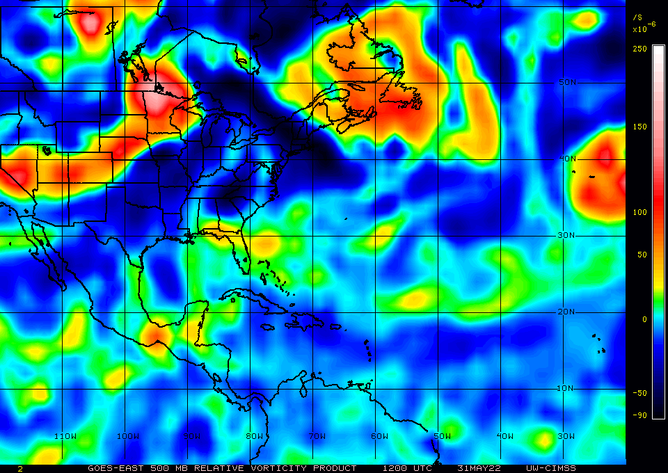
NDG wrote:blp wrote:NDG wrote:Two noticeable vortices this morning, the one from Agatha in southern MX and one over northern Belize.
Might be why the models have different solutions.
https://i.imgur.com/4lfLxly.gif
700mb and 500mb on Agatha still holding up so think it has best chance. I think will pop again once it reaches the BOC.
https://uploads.disquscdn.com/images/467e9e1cb03c56e8dd22e4c03aa28f3625211fb3c6813e0a27a868fd90a7f353.gif
https://i.ibb.co/k0zxDGf/wg8vor3.gif
The Euro focuses on Agatha's vortex while the GFS dissipates it and develops the vortex currently over the eastern Yucatan Peninsula.
Good observation and a very logical explation for each model's insistance for future track and intensity. I'd typically bet on GFS's capacity to sniff out smaller meso scale tropical development. On the flip side, Agatha may be super weak but she ain't shallow. That mid level circulation is pretty vigorous (albiet broad). If GFS wins out on a more W. Caribean new development, it'll be a S. Fla soaking Fri and Sat. If Agatha's mid level remains the dominant feature however, I may end up eating my own words as a respectable "moderate" TS potentially takes aim at somewhere between Ft Myers and Tampa.
Hmm, might be an opportune time to drive down to Englewood and snag a bunch of sharks teeth that'll surely wash up on the Manasota Key beaches!
3 likes
Personal Forecast Disclaimer:
The posts in this forum are NOT official forecast and should not be used as such. They are just the opinion of the poster and may or may not be backed by sound meteorological data. They are NOT endorsed by any professional institution or storm2k.org. For official information, please refer to the NHC and NWS products.
- skyline385
- Category 5
- Posts: 2573
- Age: 33
- Joined: Wed Aug 26, 2020 11:15 pm
- Location: Houston TX
Re: Near Yucatán / SE Gulf of Mexico development
0Z ICON looks more like a trough than a TS or STS
0 likes
- Ian2401
- Category 1
- Posts: 281
- Joined: Thu Sep 14, 2017 5:55 pm
- Location: Tallahassee, Florida
- Contact:
Re: Near Yucatán / SE Gulf of Mexico development
Big jump NW on the 00z GFS run
0 likes
FSU '24 student pursuing a degree in meteorology. Consult NHC for official information.
Re: Near Yucatán / SE Gulf of Mexico development
Ian2401 wrote:Big jump NW on the 00z GFS run
Huh? As of last glance, the GFS 0Z was only out to 48 hrs. Were you looking at the last post above? That was the ICON.
0 likes
Personal Forecast Disclaimer:
The posts in this forum are NOT official forecast and should not be used as such. They are just the opinion of the poster and may or may not be backed by sound meteorological data. They are NOT endorsed by any professional institution or storm2k.org. For official information, please refer to the NHC and NWS products.
- Ian2401
- Category 1
- Posts: 281
- Joined: Thu Sep 14, 2017 5:55 pm
- Location: Tallahassee, Florida
- Contact:
Re: Near Yucatán / SE Gulf of Mexico development
chaser1 wrote:Ian2401 wrote:Big jump NW on the 00z GFS run
Huh? As of last glance, the GFS 0Z was only out to 48 hrs. Were you looking at the last post above? That was the ICON.
Was looking at the 36hr 00z GFS which had a closed low form off the tip of the Yucatan compared to 18z which had it forming much further SE. Not as pronounced of a shift now at 66hr loaded in but still noticeably more N and faster than the 18z run. With the storm likely to be as heavily sheared as it is, how N the storm gets up the FL peninsula will matter a lot.
0 likes
FSU '24 student pursuing a degree in meteorology. Consult NHC for official information.
Re: Near Yucatán / SE Gulf of Mexico development
Ian2401 wrote:Big jump NW on the 00z GFS run
Yes, this run is much stronger and much more consolidated..
0 likes
The following post is NOT an official forecast and should not be used as such. It is just the opinion of the poster and may or may not be backed by sound meteorological data. It is NOT endorsed by any professional institution including storm2k.org For Official Information please refer to the NHC and NWS products.
Re: Near Yucatán / SE Gulf of Mexico development
Jeeez, what a flurry of last minute entries into the '22 Atlantic Season poll Might actually break a hundred participants. I guess some throw their hat in the ring for the passion, and for others it's all about the bragging rights. For me...... I'm all about winning the million dollars baby
3 likes
Personal Forecast Disclaimer:
The posts in this forum are NOT official forecast and should not be used as such. They are just the opinion of the poster and may or may not be backed by sound meteorological data. They are NOT endorsed by any professional institution or storm2k.org. For official information, please refer to the NHC and NWS products.
- skyline385
- Category 5
- Posts: 2573
- Age: 33
- Joined: Wed Aug 26, 2020 11:15 pm
- Location: Houston TX
Re: Near Yucatán / SE Gulf of Mexico development
blp wrote:Ian2401 wrote:Big jump NW on the 00z GFS run
Yes, this run is much stronger and much more consolidated..
Ended up being weaker than 18Z, I am beginning to doubt if we will even see a TS at this rate
Lots of models have backtracked on intensities in the last few runs.
0 likes
-
- Category 1
- Posts: 418
- Joined: Thu Feb 26, 2009 11:27 pm
Re: Near Yucatán / SE Gulf of Mexico development
HIGH SEAS FORECAST
NWS NATIONAL HURRICANE CENTER MIAMI FL
0430 UTC WED JUN 01 2022
42 HOUR FORECAST NEW LOW PRES POSSIBLE TROPICAL CYCLONE...INLAND NEAR 20N 88W 1006 MB.
48 HOUR FORECAST LOW PRES...POSSIBLE TROPICAL CYCLONE INLAND NEAR 21N 88W 1005 MB.
NWS NATIONAL HURRICANE CENTER MIAMI FL
0430 UTC WED JUN 01 2022
42 HOUR FORECAST NEW LOW PRES POSSIBLE TROPICAL CYCLONE...INLAND NEAR 20N 88W 1006 MB.
48 HOUR FORECAST LOW PRES...POSSIBLE TROPICAL CYCLONE INLAND NEAR 21N 88W 1005 MB.
0 likes
- galaxy401
- Category 5
- Posts: 2300
- Age: 29
- Joined: Sat Aug 25, 2012 9:04 pm
- Location: Casa Grande, Arizona
Re: Near Yucatán / SE Gulf of Mexico development
Should be an Invest shortly. Now 50%.
Tropical Weather Outlook
NWS National Hurricane Center Miami FL
200 AM EDT Wed Jun 1 2022
For the North Atlantic...Caribbean Sea and the Gulf of Mexico:
Near the Yucatan Peninsula and Southeastern Gulf of Mexico:
A large area of disturbed weather located near the Yucatan Peninsula
is interacting with an upper-level trough over the Gulf of Mexico
and producing a broad region of disorganized showers and
thunderstorms. Environmental conditions appear marginally conducive
for gradual development, and this system is likely to become a
tropical depression by the weekend as it moves northeastward into
the northwestern Caribbean Sea, southeastern Gulf of Mexico, and
crosses the Florida Peninsula. Regardless of development, locally
heavy rainfall is likely across portions of southeastern Mexico, the
Yucatan Peninsula, Guatemala, and Belize during the next couple of
days, spreading across western Cuba, southern Florida, and the
Florida Keys on Friday and Saturday. Interests in the Yucatan
Peninsula, western Cuba, the Florida Keys, and the Florida Peninsula
should monitor the progress of this system.
* Formation chance through 48 hours...medium...50 percent.
* Formation chance through 5 days...high...70 percent.
0 likes
Got my eyes on moving right into Hurricane Alley: Florida.
Who is online
Users browsing this forum: Christiana, Cpv17, Google Adsense [Bot], Ivanhater, JayTX, jgh, kevin, loon, South Texas Storms and 95 guests