Trough of low pressure in Western Caribbean (Is Invest 95L)
Moderator: S2k Moderators
Forum rules

The posts in this forum are NOT official forecasts and should not be used as such. They are just the opinion of the poster and may or may not be backed by sound meteorological data. They are NOT endorsed by any professional institution or STORM2K. For official information, please refer to products from the National Hurricane Center and National Weather Service.
Re: Possible SW Caribbean Development
Happy Hour para-GFS is like a Mitch #2 that disintegrates within 24 hours. This model is definitely drunk. 
1 likes
Personal Forecast Disclaimer:
The posts in this forum are NOT official forecasts and should not be used as such. They are just the opinion of the poster and may or may not be backed by sound meteorological data. They are NOT endorsed by any professional institution or storm2k.org. For official information, please refer to the NHC and NWS products.
The posts in this forum are NOT official forecasts and should not be used as such. They are just the opinion of the poster and may or may not be backed by sound meteorological data. They are NOT endorsed by any professional institution or storm2k.org. For official information, please refer to the NHC and NWS products.
-
TheStormExpert
Re: Possible SW Caribbean Development
LarryWx wrote:Happy Hour para-GFS is like a Mitch #2 that disintegrates within 24 hours. This model is definitely drunk.
Which is why I’m not believing it. It’s smoking the goods!
1 likes
-
ElectricStorm

- Category 5

- Posts: 5157
- Age: 25
- Joined: Tue Aug 13, 2019 11:23 pm
- Location: Norman, OK
Re: Possible SW Caribbean Development
TheStormExpert wrote:Loveweather12 wrote:Where did you get that conclusion from?TheStormExpert wrote:So basically we went from talk of a major hurricane in the Western Caribbean to talk of basically nothing or something weak. Oh how the tides change!
Going off the models and the fact that the only mode that really does much with this the GFS-P, and that doesn’t seem like a reliable model.
Like I said on the last page... models have been crap this year so even though some of them are trending weaker really doesn't mean a whole lot based on their performance this year...
3 likes
B.S Meteorology, University of Oklahoma '25
Please refer to the NHC, NWS, or SPC for official information.
Please refer to the NHC, NWS, or SPC for official information.

Re: Possible SW Caribbean Development
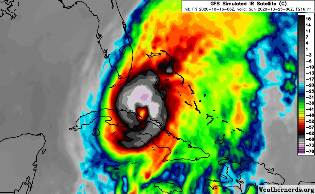
All of the models are having problems with this. The GFS is too enthusiastic with a weakness in the ridge, the GFS-Para is too unenthusiastic about movement, the Euro doesn’t show anything, the CMC tries to develop 93L’s remnants in the gyre, and the ICON can’t even get the genesis location right.
I’m thinking the most likely solution is the gyre starting in the SWCar on October 19th and moving generally NW as it develops into a TC within 24-72 hours of that date, before eventually getting tugged north and impacting Cuba.
I’m thinking the most likely solution is the gyre starting in the SWCar on October 19th and moving generally NW as it develops into a TC within 24-72 hours of that date, before eventually getting tugged north and impacting Cuba.
7 likes
Irene '11 Sandy '12 Hermine '16 5/15/2018 Derecho Fay '20 Isaias '20 Elsa '21 Henri '21 Ida '21
I am only a meteorology enthusiast who knows a decent amount about tropical cyclones. Look to the professional mets, the NHC, or your local weather office for the best information.
I am only a meteorology enthusiast who knows a decent amount about tropical cyclones. Look to the professional mets, the NHC, or your local weather office for the best information.
-
EquusStorm
- Category 5
- Posts: 1649
- Age: 35
- Joined: Thu Nov 07, 2013 1:04 pm
- Location: Jasper, AL
- Contact:
Re: Possible SW Caribbean Development
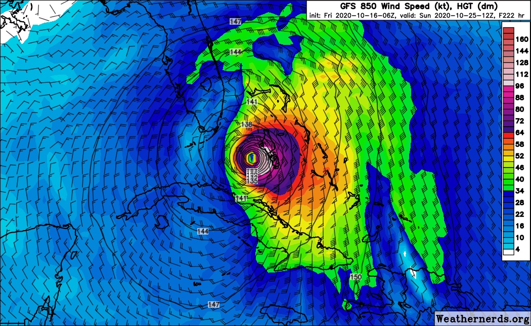
I definitely have my eyes on upper level conditions whenever genesis eventually happens. We know water temperatures can support a pretty high end system but as we saw with Delta, little wrenches thrown in like moving a bit out from under the ULAC and getting sheared to pieces can disrupt an otherwise pristine environment. But if it becomes a very slow mover like Para was suggesting earlier (not likely) could be big trouble. High potential ceiling, low confidence; lotta people need to watch.
3 likes
Colors of lost purpose on the canvas of irrelevance
Not a meteorologist, in fact more of an idiot than anything. You should probably check with the NHC or a local NWS office for official information.
Not a meteorologist, in fact more of an idiot than anything. You should probably check with the NHC or a local NWS office for official information.
-
SFLcane

- S2K Supporter

- Posts: 10281
- Age: 48
- Joined: Sat Jun 05, 2010 1:44 pm
- Location: Lake Worth Florida
Re: Possible SW Caribbean Development
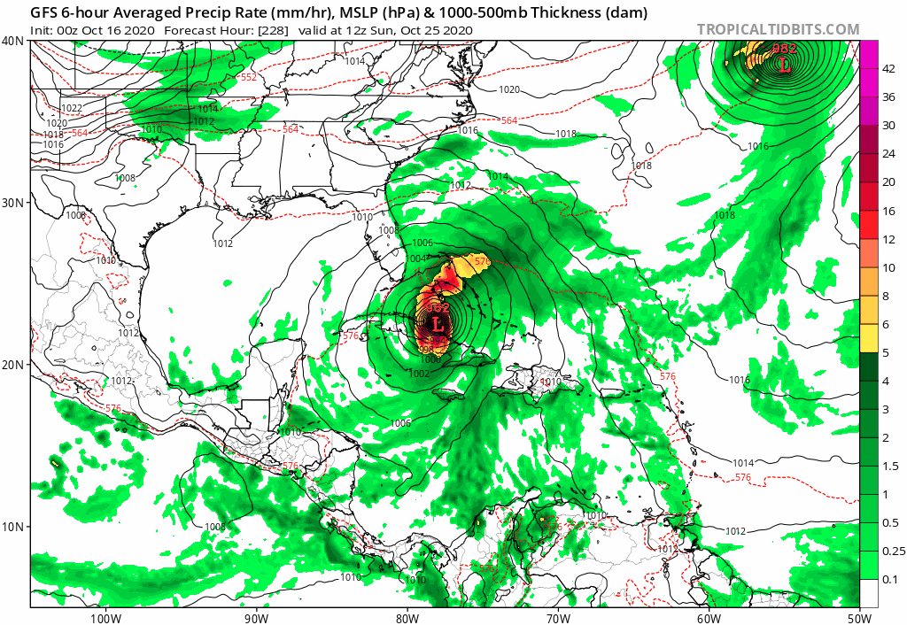
O0z Gfs stronger and trended westward from previous 18z run just missing SFL.

0 likes
-
CrazyC83
- Professional-Met

- Posts: 34316
- Joined: Tue Mar 07, 2006 11:57 pm
- Location: Deep South, for the first time!
Re: Possible SW Caribbean Development
This feels like a 2012 deja vu...how does the long-range setup compare to during Sandy?
1 likes
-
crownweather

- S2K Supporter
- Posts: 602
- Age: 51
- Joined: Sat Aug 12, 2006 9:21 am
- Location: Sturbridge, Massachusetts
- Contact:
Re: Possible SW Caribbean Development
4 likes
Rob Lightbown
Crown Weather Services
https://crownweather.com
Crown Weather Services
https://crownweather.com
Re: Possible SW Caribbean Development
0z GEFS: mean not as far east as the 18Z with still a majority of the TC members moving quickly over Bahamas but several getting left behind and then moving into the GOM:


Two hit S FL early with one of those looping back down into the Caribbean. Two go into the Gulf and then hit W FL. One of those then goes up the coast just offshore giving the SE coast ~6-8" of rainfall. Another slow mover later hits S FL and then like Hurricane King of 1950 then goes up the peninsula. Still 4 members with a H moving very slowly in the W Car on 10/29 (see next post)! I guess they're trying to be the next version of Mitch.
Two hit S FL early with one of those looping back down into the Caribbean. Two go into the Gulf and then hit W FL. One of those then goes up the coast just offshore giving the SE coast ~6-8" of rainfall. Another slow mover later hits S FL and then like Hurricane King of 1950 then goes up the peninsula. Still 4 members with a H moving very slowly in the W Car on 10/29 (see next post)! I guess they're trying to be the next version of Mitch.
Last edited by LarryWx on Fri Oct 16, 2020 1:52 am, edited 4 times in total.
1 likes
Personal Forecast Disclaimer:
The posts in this forum are NOT official forecasts and should not be used as such. They are just the opinion of the poster and may or may not be backed by sound meteorological data. They are NOT endorsed by any professional institution or storm2k.org. For official information, please refer to the NHC and NWS products.
The posts in this forum are NOT official forecasts and should not be used as such. They are just the opinion of the poster and may or may not be backed by sound meteorological data. They are NOT endorsed by any professional institution or storm2k.org. For official information, please refer to the NHC and NWS products.
Re: Possible SW Caribbean Development
Still 4 H members out of 31 total in the W Car as late as 10/29 with one of those that had hit S FL much earlier and then looped back down!

4 likes
Personal Forecast Disclaimer:
The posts in this forum are NOT official forecasts and should not be used as such. They are just the opinion of the poster and may or may not be backed by sound meteorological data. They are NOT endorsed by any professional institution or storm2k.org. For official information, please refer to the NHC and NWS products.
The posts in this forum are NOT official forecasts and should not be used as such. They are just the opinion of the poster and may or may not be backed by sound meteorological data. They are NOT endorsed by any professional institution or storm2k.org. For official information, please refer to the NHC and NWS products.
Re: Possible SW Caribbean Development
End of the marathon 0Z GEFS still has those 4 canes with one hitting Keys/far S FL and 2 of the other 3 likely on the way to FL....so I estimate a respectable 8 of the 31 members hit or are about to hit FL as of the end...so FL far from being out of the woods:

5 likes
Personal Forecast Disclaimer:
The posts in this forum are NOT official forecasts and should not be used as such. They are just the opinion of the poster and may or may not be backed by sound meteorological data. They are NOT endorsed by any professional institution or storm2k.org. For official information, please refer to the NHC and NWS products.
The posts in this forum are NOT official forecasts and should not be used as such. They are just the opinion of the poster and may or may not be backed by sound meteorological data. They are NOT endorsed by any professional institution or storm2k.org. For official information, please refer to the NHC and NWS products.


-
chris_fit

- Category 5
- Posts: 3261
- Age: 43
- Joined: Wed Sep 10, 2003 11:58 pm
- Location: Tampa Bay Area, FL
Re: Possible SW Caribbean Development
Subtle W shift (when compared to the 00Z) on the 06Z GFS

0 likes
-
SFLcane
- S2K Supporter
- Posts: 10281
- Age: 48
- Joined: Sat Jun 05, 2010 1:44 pm
- Location: Lake Worth Florida
Re: Possible SW Caribbean Development
06z gfs shifted westward once closer to SFL. Interesting if these trends continue
0 likes
-
SFLcane
- S2K Supporter
- Posts: 10281
- Age: 48
- Joined: Sat Jun 05, 2010 1:44 pm
- Location: Lake Worth Florida
Re: Possible SW Caribbean Development
chris_fit wrote:Subtle W shift (when compared to the 00Z) on the 06Z GFS
https://i.imgur.com/8wdd9dz.png
It shifted west on the 00z and now again on the 06z.
0 likes
-
AJC3

- Admin

- Posts: 4156
- Age: 62
- Joined: Tue Aug 31, 2004 7:04 pm
- Location: Ballston Spa, New York
- Contact:
Re: Possible SW Caribbean Development
N2FSU wrote:0z Euro +216
https://uploads.tapatalk-cdn.com/20201016/c827fa4bd82fb3b1f94a61e1d4d55ed2.jpg
Sent from my iPhone using Tapatalk
it still doesn't do much at all with the NW Caribbean disturbance, and instead develops a separate baroclinic low over the eastern GOMEX, which it takes rapidly NE to NNE through the SE CONUS.
0 likes
-
toad strangler

- S2K Supporter
- Posts: 4546
- Joined: Sun Jul 28, 2013 3:09 pm
- Location: Earth
- Contact:
Re: Possible SW Caribbean Development
SFLcane wrote:I am not liking these gfs trends...
https://i.postimg.cc/cHNF3YVS/1-F8-E8-EFD-7316-4-FF1-BDB9-2586-E4-BC8222.jpg
https://i.postimg.cc/90DwFgJF/CB1-CC5-D2-A28-E-421-C-8-ADA-EA85900-B7272.jpg
WAY too close for comfort being 200 plus hours out. It's not like this will stick on a rail every run.
0 likes
My Weather Station
https://www.wunderground.com/dashboard/pws/KFLPORTS603
https://www.wunderground.com/dashboard/pws/KFLPORTS603
Who is online
Users browsing this forum: No registered users and 130 guests