According to latest NHC Surface Analysis Chart, this wave has develop an area of low pressure (1010mb) which will be reflected in the next TWD at 2pm
http://www.nhc.noaa.gov/tafb/ATSA_06Z.gif
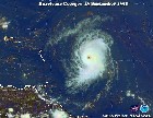
Central Atlantic Wave,Midway Between Africa and L Antilles
Moderator: S2k Moderators
Forum rules

The posts in this forum are NOT official forecasts and should not be used as such. They are just the opinion of the poster and may or may not be backed by sound meteorological data. They are NOT endorsed by any professional institution or STORM2K. For official information, please refer to products from the National Hurricane Center and National Weather Service.
-
HurricaneMaster_PR

- Category 2

- Posts: 795
- Joined: Tue Jul 22, 2003 6:23 pm
- Location: San Juan, Puerto Rico


-
O Town
- S2K Supporter

- Posts: 5205
- Age: 52
- Joined: Wed Sep 07, 2005 9:37 pm
- Location: Orlando, Florida 28°35'35"N 81°22'55"W
HurricaneMaster_PR wrote:According to latest NHC Surface Analysis Chart, this wave has develop an area of low pressure (1010mb) which will be reflected in the next TWD at 2pm
http://www.nhc.noaa.gov/tafb/ATSA_06Z.gif
That area not looking so hot this morning.

0 likes
-
cycloneye

- Admin

- Posts: 148763
- Age: 69
- Joined: Thu Oct 10, 2002 10:54 am
- Location: San Juan, Puerto Rico
ABNT20 KNHC 311507
TWOAT
TROPICAL WEATHER OUTLOOK
NWS TPC/NATIONAL HURRICANE CENTER MIAMI FL
1130 AM EDT THU AUG 31 2006
FOR THE NORTH ATLANTIC...CARIBBEAN SEA AND THE GULF OF MEXICO...
THE NATIONAL HURRICANE CENTER IS ISSUING ADVISORIES ON TROPICAL
STORM ERNESTO...LOCATED ABOUT 105 MILES SOUTH-SOUTHEAST OF
CHARLESTON SOUTH CAROLINA.
A TROPICAL WAVE LOCATED ABOUT 750 MILES SOUTHWEST OF THE
CAPE VERDE ISLANDS REMAINS DISORGANIZED. DEVELOPMENT...IS NOT
EXPECTED TODAY OR FRIDAY.
ELSEWHERE...TROPICAL STORM FORMATION IS NOT EXPECTED THROUGH
FRIDAY.
$$
FORECASTER AVILA
0 likes
Visit the Caribbean-Central America Weather Thread where you can find at first post web cams,radars
and observations from Caribbean basin members Click Here
and observations from Caribbean basin members Click Here
-
ConvergenceZone
.gif)
- Category 5

- Posts: 5241
- Joined: Fri Jul 29, 2005 1:40 am
- Location: Northern California
-
Evil Jeremy

- S2K Supporter
- Posts: 5463
- Age: 32
- Joined: Mon Apr 10, 2006 2:10 pm
- Location: Los Angeles, CA
cycloneye wrote:ABNT20 KNHC 311507
TWOAT
TROPICAL WEATHER OUTLOOK
NWS TPC/NATIONAL HURRICANE CENTER MIAMI FL
1130 AM EDT THU AUG 31 2006
DEVELOPMENT...IS NOT
EXPECTED TODAY OR FRIDAY.
ELSEWHERE...TROPICAL STORM FORMATION IS NOT EXPECTED THROUGH
FRIDAY.
$$
FORECASTER AVILA
first yime they ever say that!
0 likes
-
Windsurfer_NYC
- Tropical Storm

- Posts: 233
- Joined: Wed Jun 07, 2006 3:27 pm
- Location: New York, NY
HurricaneMaster_PR wrote:According to latest NHC Surface Analysis Chart, this wave has develop an area of low pressure (1010mb) which will be reflected in the next TWD at 2pm
http://www.nhc.noaa.gov/tafb/ATSA_06Z.gif
Note that 6 hours later the Surface Analysis removes the closed low: http://www.nhc.noaa.gov/tafb/ATSA_12Z.gif
DISPT is written on both, which I take to mean "Dissipating"...
0 likes
-
HurricaneMaster_PR
- Category 2
- Posts: 795
- Joined: Tue Jul 22, 2003 6:23 pm
- Location: San Juan, Puerto Rico
Windsurfer_NYC wrote:HurricaneMaster_PR wrote:According to latest NHC Surface Analysis Chart, this wave has develop an area of low pressure (1010mb) which will be reflected in the next TWD at 2pm
http://www.nhc.noaa.gov/tafb/ATSA_06Z.gif
Note that 6 hours later the Surface Analysis removes the closed low: http://www.nhc.noaa.gov/tafb/ATSA_12Z.gif
DISPT is written on both, which I take to mean "Dissipating"...
Nope, the one we are talking in this thread says New...Which means a new area of low pressure is expected to develop there...
0 likes
-
cycloneye
- Admin
- Posts: 148763
- Age: 69
- Joined: Thu Oct 10, 2002 10:54 am
- Location: San Juan, Puerto Rico
AN ATLANTIC OCEAN TROPICAL WAVE IS ALONG 34W/35W SOUTH OF
16N MOVING WEST 10 KT. A FEW CELLS OF STRONG SHOWERS AND
THUNDERSTORMS ARE FOUND FROM 11N TO 13N BETWEEN 34W AND 36W.
THE GFS MODEL IS FORECASTING A 1011 MB SURFACE LOW PRESSURE
CENTER TO FORM IN 24 HOURS IN A LOCATION A BIT WEST OF WHERE
THIS WAVE IS SITUATED NOW.
From the 2 PM Discussion.
16N MOVING WEST 10 KT. A FEW CELLS OF STRONG SHOWERS AND
THUNDERSTORMS ARE FOUND FROM 11N TO 13N BETWEEN 34W AND 36W.
THE GFS MODEL IS FORECASTING A 1011 MB SURFACE LOW PRESSURE
CENTER TO FORM IN 24 HOURS IN A LOCATION A BIT WEST OF WHERE
THIS WAVE IS SITUATED NOW.
From the 2 PM Discussion.
0 likes
Visit the Caribbean-Central America Weather Thread where you can find at first post web cams,radars
and observations from Caribbean basin members Click Here
and observations from Caribbean basin members Click Here
cycloneye wrote:AN ATLANTIC OCEAN TROPICAL WAVE IS ALONG 34W/35W SOUTH OF
16N MOVING WEST 10 KT. A FEW CELLS OF STRONG SHOWERS AND
THUNDERSTORMS ARE FOUND FROM 11N TO 13N BETWEEN 34W AND 36W.
THE GFS MODEL IS FORECASTING A 1011 MB SURFACE LOW PRESSURE
CENTER TO FORM IN 24 HOURS IN A LOCATION A BIT WEST OF WHERE
THIS WAVE IS SITUATED NOW.
From the 2 PM Discussion.
That sure does lead one to believe that they are expecting it to form.. I still doubt it...
0 likes
tgenius wrote:cycloneye wrote:AN ATLANTIC OCEAN TROPICAL WAVE IS ALONG 34W/35W SOUTH OF
16N MOVING WEST 10 KT. A FEW CELLS OF STRONG SHOWERS AND
THUNDERSTORMS ARE FOUND FROM 11N TO 13N BETWEEN 34W AND 36W.
THE GFS MODEL IS FORECASTING A 1011 MB SURFACE LOW PRESSURE
CENTER TO FORM IN 24 HOURS IN A LOCATION A BIT WEST OF WHERE
THIS WAVE IS SITUATED NOW.
From the 2 PM Discussion.
That sure does lead one to believe that they are expecting it to form.. I still doubt it...
They are probably paying attention to the models. The model solutions are quite convoluted, but they are unanimously developing something in this area by the weekend. In fact, most models feel that two systems will develop (one at around 35W the other around 20W)
0 likes

-
GeneratorPower

- S2K Supporter
- Posts: 1648
- Age: 46
- Joined: Sun Dec 18, 2005 11:48 pm
- Location: Huntsville, AL
Looking better with every frame. I haven't heard any pro met opinions on this one, but would like to.
http://www.ssd.noaa.gov/goes/east/catl/loop-avn.html
http://www.ssd.noaa.gov/goes/east/catl/loop-avn.html
0 likes
-
Weathermaster
- Tropical Depression

- Posts: 79
- Joined: Thu Sep 04, 2003 10:33 am
- Location: Carolina, PR
-
jhamps10
i agree that it is looking much better today, I think that florence is going to wait until ernesto is finally dead and gone, and then we will still be up until 1 or 2 in the morning tracking this one, and who knows it may even be close enough for recon to get into it in a couple of days! More fun for us.
0 likes
-
Josephine96
-
Aquawind

- Category 5
- Posts: 6714
- Age: 62
- Joined: Mon Jun 16, 2003 10:41 pm
- Location: Salisbury, NC
- Contact:
Maybe that'll soon be #6
I think it has a very good chance..
http://cimss.ssec.wisc.edu/tropic/real- ... g8shr.html
0 likes

-
HurricaneMaster_PR
- Category 2
- Posts: 795
- Joined: Tue Jul 22, 2003 6:23 pm
- Location: San Juan, Puerto Rico
TROPICAL WEATHER OUTLOOK
NWS TPC/NATIONAL HURRICANE CENTER MIAMI FL
530 PM EDT THU AUG 31 2006
FOR THE NORTH ATLANTIC...CARIBBEAN SEA AND THE GULF OF MEXICO...
A TROPICAL WAVE LOCATED ABOUT 700 MILES WEST-SOUTHWEST OF THE
CAPE VERDE ISLANDS HAS BECOME A LITTLE BETTER ORGANIZED THIS
AFTERNOON. ADDITIONAL SLOW DEVELOPMENT IS POSSIBLE OVER THE NEXT
DAY OR TWO AS THE SYSTEM MOVES SLOWLY WESTWARD.
ELSEWHERE...TROPICAL STORM FORMATION IS NOT EXPECTED THROUGH
FRIDAY.
0 likes
Who is online
Users browsing this forum: Team Ghost and 58 guests