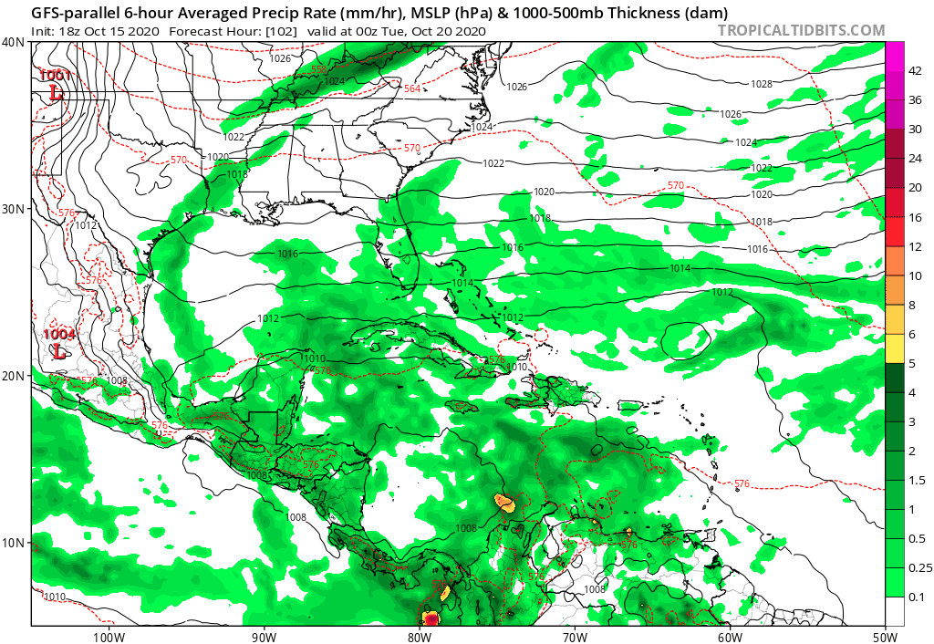
Trough of low pressure in Western Caribbean (Is Invest 95L)

This is the general tropical discussion area. Anyone can take their shot at predicting a storms path.

Moderator: S2k Moderators

Forum rules

The posts in this forum are NOT official forecasts and should not be used as such. They are just the opinion of the poster and may or may not be backed by sound meteorological data. They are NOT endorsed by any professional institution or STORM2K. For official information, please refer to products from the National Hurricane Center and National Weather Service.

Help Support Storm2K
Message
Author
underthwx
Category 5
Category 5
Posts: 2360
Joined: Sat Jul 30, 2011 2:14 pm
Location: Brazoria County Texas

Re: Possible SW Caribbean Development

#201 Postby underthwx » Thu Oct 15, 2020 6:37 pm

SFLcane wrote:
cycloneye wrote:
A broad area of low pressure could form by early next week over
the southwestern Caribbean Sea. Some gradual development of the
system will be possible through the middle of next week while it
remains nearly stationary over the southwestern Caribbean Sea.
* Formation chance through 48 hours...low...near 0 percent.
* Formation chance through 5 days...low...20 percent.


Nearly stationary?


Thats got me even more curious....
0 likes   

User avatar
ElectricStorm
Category 5
Category 5
Posts: 5044
Age: 24
Joined: Tue Aug 13, 2019 11:23 pm
Location: Skiatook, OK / Norman, OK

Re: Possible SW Caribbean Development

#202 Postby ElectricStorm » Thu Oct 15, 2020 6:49 pm

emeraldislenc wrote:Not trying to be rude, but I am getting tired of the phrase "Happy Hour" in some of the posts about different models. I really enjoy this site, but that phrased is really over used.

I think the 18z GFS is the only one that has that title. Because it tends to make everything intense
1 likes   
B.S Meteorology, University of Oklahoma '25

Please refer to the NHC, NWS, or SPC for official information.

User avatar
aspen
Category 5
Category 5
Posts: 8818
Joined: Sat Oct 12, 2019 7:10 pm
Location: Connecticut, USA

Re: Possible SW Caribbean Development

#203 Postby aspen » Thu Oct 15, 2020 7:22 pm

18z GFS-Para squishes the 10/30 AOI again and has a developing/weak TC at 126 hours. Let’s see if it remains weak like the GFS or it explodes like the last couple of Para runs.
0 likes   
Irene '11 Sandy '12 Hermine '16 5/15/2018 Derecho Fay '20 Isaias '20 Elsa '21 Henri '21 Ida '21

I am only a meteorology enthusiast who knows a decent amount about tropical cyclones. Look to the professional mets, the NHC, or your local weather office for the best information.

User avatar
SouthFLTropics
Category 5
Category 5
Posts: 4236
Age: 50
Joined: Thu Aug 14, 2003 8:04 am
Location: Port St. Lucie, Florida

Re: Possible SW Caribbean Development

#204 Postby SouthFLTropics » Thu Oct 15, 2020 7:32 pm

GFS PARA... What are you doing???


Sent from my iPhone using Tapatalk
2 likes   
Fourth Generation Florida Native

Personal Storm History: David 79, Andrew 92, Erin 95, Floyd 99, Irene 99, Frances 04, Jeanne 04, Wilma 05, Matthew 16, Irma 17, Ian 22, Nicole 22, Milton 24

User avatar
ElectricStorm
Category 5
Category 5
Posts: 5044
Age: 24
Joined: Tue Aug 13, 2019 11:23 pm
Location: Skiatook, OK / Norman, OK

Re: Possible SW Caribbean Development

#205 Postby ElectricStorm » Thu Oct 15, 2020 7:44 pm

I know some of the models are trending weaker... But I still don't trust any storm forming way down there in the SW Caribbean. Given the bathwater and very high OHC down there, depending on the upper-level environment, I think it can get rather strong. The models had a really tough time with Gamma and Delta down there, especially Delta. None of them showed Delta getting that strong until it was close to, or already formed. After watching the RI's of Gamma and Delta, anything that forms down there is automatically a big concern for me right now, regardless of what the models show.
1 likes   
B.S Meteorology, University of Oklahoma '25

Please refer to the NHC, NWS, or SPC for official information.

User avatar
gatorcane
S2K Supporter
S2K Supporter
Posts: 23691
Age: 47
Joined: Sun Mar 13, 2005 3:54 pm
Location: Boca Raton, FL

Re: Possible SW Caribbean Development

#206 Postby gatorcane » Thu Oct 15, 2020 7:46 pm

18Z GFS P with missing frames, weaker and smaller for sure:

Image
0 likes   

User avatar
aspen
Category 5
Category 5
Posts: 8818
Joined: Sat Oct 12, 2019 7:10 pm
Location: Connecticut, USA

Re: Possible SW Caribbean Development

#207 Postby aspen » Thu Oct 15, 2020 7:51 pm

Tiny circulation + GFS-Para + 18z run = probably another nuts run in terms of intensity and track
2 likes   
Irene '11 Sandy '12 Hermine '16 5/15/2018 Derecho Fay '20 Isaias '20 Elsa '21 Henri '21 Ida '21

I am only a meteorology enthusiast who knows a decent amount about tropical cyclones. Look to the professional mets, the NHC, or your local weather office for the best information.

User avatar
gatorcane
S2K Supporter
S2K Supporter
Posts: 23691
Age: 47
Joined: Sun Mar 13, 2005 3:54 pm
Location: Boca Raton, FL

Re: Possible SW Caribbean Development

#208 Postby gatorcane » Thu Oct 15, 2020 7:51 pm

The NAVGEM has been remarkably bearish on this system. Nothing even shows up on the latest run.

If something big is going to form, this model would probably be showing it, as it can have a bias for Western Caribbean genesis.

Image
3 likes   

Frank2
Category 5
Category 5
Posts: 4061
Joined: Mon Jul 25, 2005 12:47 pm

Re: Possible SW Caribbean Development

#209 Postby Frank2 » Thu Oct 15, 2020 7:56 pm

A few observations...

Per the 8 p.m. TWO the NHC is statig a more typical disturbance for October that moves little. In fact the SW Caribbean season so-to-speak is almost year-round. That area generated a TS in February, 1950 that made landfall in Tampa...

But normally as it gets later very few tropical lows survive once they cross 20N, and especially 25N...

The GFS might have initialized the low further west, but as the other models they are trending weaker and to the east.

P.S. Winter is quickly making itself felt up north (very surprised to see a low of 7F for Calgary by this weekend).

P.P.S. I was looking at the Wilma photos, and from the outset that was a large low pressure area - I think most here at the time knew it was trouble if it consolidated.
0 likes   

User avatar
SFLcane
S2K Supporter
S2K Supporter
Posts: 10163
Age: 47
Joined: Sat Jun 05, 2010 1:44 pm
Location: Lake Worth Florida

Re: Possible SW Caribbean Development

#210 Postby SFLcane » Thu Oct 15, 2020 8:12 pm

18z Para Lol 929mb down there...

:spam:
Last edited by SFLcane on Thu Oct 15, 2020 8:12 pm, edited 1 time in total.
0 likes   

User avatar
aspen
Category 5
Category 5
Posts: 8818
Joined: Sat Oct 12, 2019 7:10 pm
Location: Connecticut, USA

Re: Possible SW Caribbean Development

#211 Postby aspen » Thu Oct 15, 2020 8:12 pm

aspen wrote:Tiny circulation + GFS-Para + 18z run = probably another nuts run in terms of intensity and track

Call it. 929 mbar and stalling near the Yucatán.

Let’s see how low the Para can go, just for entertainment purposes.
0 likes   
Irene '11 Sandy '12 Hermine '16 5/15/2018 Derecho Fay '20 Isaias '20 Elsa '21 Henri '21 Ida '21

I am only a meteorology enthusiast who knows a decent amount about tropical cyclones. Look to the professional mets, the NHC, or your local weather office for the best information.

underthwx
Category 5
Category 5
Posts: 2360
Joined: Sat Jul 30, 2011 2:14 pm
Location: Brazoria County Texas

Re: Possible SW Caribbean Development

#212 Postby underthwx » Thu Oct 15, 2020 8:20 pm

Weather Dude wrote:I know some of the models are trending weaker... But I still don't trust any storm forming way down there in the SW Caribbean. Given the bathwater and very high OHC down there, depending on the upper-level environment, I think it can get rather strong. The models had a really tough time with Gamma and Delta down there, especially Delta. None of them showed Delta getting that strong until it was close to, or already formed. After watching the RI's of Gamma and Delta, anything that forms down there is automatically a big concern for me right now, regardless of what the models show.


Agree....probably the most rational assessment anyone can make at this point...
0 likes   

TheStormExpert

Re: Possible SW Caribbean Development

#213 Postby TheStormExpert » Thu Oct 15, 2020 8:30 pm

So basically we went from talk of a major hurricane in the Western Caribbean to talk of basically nothing or something weak. Oh how the tides change! :lol:
0 likes   

TheStormExpert

Re: Possible SW Caribbean Development

#214 Postby TheStormExpert » Thu Oct 15, 2020 8:31 pm

gatorcane wrote:The NAVGEM has been remarkably bearish on this system. Nothing even shows up on the latest run.

If something big is going to form, this model would probably be showing it, as it can have a bias for Western Caribbean genesis.

https://i.postimg.cc/vTzKKhGN/nvg10-sfc10m-180-go-mex.gif

Basically the Subtropical Atlantic storm robs all the energy.
1 likes   

User avatar
toad strangler
S2K Supporter
S2K Supporter
Posts: 4543
Joined: Sun Jul 28, 2013 3:09 pm
Location: Earth
Contact:

Re: Possible SW Caribbean Development

#215 Postby toad strangler » Thu Oct 15, 2020 8:32 pm

gatorcane wrote:The NAVGEM has been remarkably bearish on this system. Nothing even shows up on the latest run.

If something big is going to form, this model would probably be showing it, as it can have a bias for Western Caribbean genesis.

https://i.postimg.cc/vTzKKhGN/nvg10-sfc10m-180-go-mex.gif


Garbage tropical model :roll:
0 likes   

User avatar
aspen
Category 5
Category 5
Posts: 8818
Joined: Sat Oct 12, 2019 7:10 pm
Location: Connecticut, USA

Re: Possible SW Caribbean Development

#216 Postby aspen » Thu Oct 15, 2020 8:34 pm

Zeta refuses to budge in the medium to long range on this run. The GFS-P is definitely very confused regarding the steering currents after 7-10 days out.
0 likes   
Irene '11 Sandy '12 Hermine '16 5/15/2018 Derecho Fay '20 Isaias '20 Elsa '21 Henri '21 Ida '21

I am only a meteorology enthusiast who knows a decent amount about tropical cyclones. Look to the professional mets, the NHC, or your local weather office for the best information.

Loveweather12
Tropical Storm
Tropical Storm
Posts: 136
Joined: Thu Aug 20, 2020 2:37 pm

Re: Possible SW Caribbean Development

#217 Postby Loveweather12 » Thu Oct 15, 2020 8:36 pm

Where did you get that conclusion from?


TheStormExpert wrote:So basically we went from talk of a major hurricane in the Western Caribbean to talk of basically nothing or something weak. Oh how the tides change! :lol:
0 likes   

User avatar
MetroMike
Category 4
Category 4
Posts: 952
Joined: Sun Aug 29, 2004 8:13 pm
Location: Tampa Bay
Contact:

Re: Possible SW Caribbean Development

#218 Postby MetroMike » Thu Oct 15, 2020 8:39 pm

aspen wrote:Zeta refuses to budge in the medium to long range on this run. The GFS-P is definitely very confused regarding the steering currents after 7-10 days out.


What are you prematurely calling Zeta anyhow?
0 likes   

User avatar
aspen
Category 5
Category 5
Posts: 8818
Joined: Sat Oct 12, 2019 7:10 pm
Location: Connecticut, USA

Re: Possible SW Caribbean Development

#219 Postby aspen » Thu Oct 15, 2020 9:04 pm

MetroMike wrote:
aspen wrote:Zeta refuses to budge in the medium to long range on this run. The GFS-P is definitely very confused regarding the steering currents after 7-10 days out.


What are you prematurely calling Zeta anyhow?

This Caribbean system. It looks like any subtropical development will happen soon enough to steal the name Epsilon.
2 likes   
Irene '11 Sandy '12 Hermine '16 5/15/2018 Derecho Fay '20 Isaias '20 Elsa '21 Henri '21 Ida '21

I am only a meteorology enthusiast who knows a decent amount about tropical cyclones. Look to the professional mets, the NHC, or your local weather office for the best information.

TheStormExpert

Re: Possible SW Caribbean Development

#220 Postby TheStormExpert » Thu Oct 15, 2020 9:12 pm

Loveweather12 wrote:Where did you get that conclusion from?


TheStormExpert wrote:So basically we went from talk of a major hurricane in the Western Caribbean to talk of basically nothing or something weak. Oh how the tides change! :lol:

Going off the models and the fact that the only mode that really does much with this the GFS-P, and that doesn’t seem like a reliable model.
0 likes   


Return to “Talkin' Tropics”

Who is online

Users browsing this forum: CyclonicFury, StormWeather, StPeteMike, Stratton23, Ulf and 43 guests