The 2005 Hurricane Season Stats(LONG)(Caution Dial-up users)

This is the general tropical discussion area. Anyone can take their shot at predicting a storms path.

Moderator: S2k Moderators

Forum rules

The posts in this forum are NOT official forecasts and should not be used as such. They are just the opinion of the poster and may or may not be backed by sound meteorological data. They are NOT endorsed by any professional institution or STORM2K. For official information, please refer to products from the National Hurricane Center and National Weather Service.

Help Support Storm2K
Message
Author
User avatar
wxmann_91
Category 5
Category 5
Posts: 8013
Age: 34
Joined: Fri Jul 15, 2005 2:49 pm
Location: Southern California
Contact:

#21 Postby wxmann_91 » Thu Sep 15, 2005 5:52 pm

Sorry if this annoys anyone I'd just like everyone to see my updated version of this thread.


Never, Astroman! Thanks for gathering all the info. Interesting stuff.
0 likes   

User avatar
Astro_man92
Category 5
Category 5
Posts: 1493
Joined: Sun Jul 17, 2005 1:26 am
Contact:

#22 Postby Astro_man92 » Fri Sep 16, 2005 8:15 pm

Once again if you are using Dial-up and you are reading this you must have waited a looooong time!

Once more an update and an add on

Tell me what you think about me adding:
    The Average Category for the year (by wind)
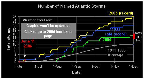
    The highest average wind speed (I think Emily)
    Lowest average central pressure
    Highest average wind speed (for each storm)
    Lowest average central pressure (for each storm that lasted more than 3 days)


Well that is all for the moment if you have a suggestion that you think I should add please tell me I'd like this to be very useful.

Eventually I’m going to take screen shots and print then out and put it on my wall he he

:SpellChecked: {spellcheck} "A ok"
0 likes   

User avatar
cjrciadt
S2K Supporter
S2K Supporter
Posts: 1616
Joined: Mon Aug 22, 2005 1:11 pm
Location: Kissimmee, FL

#23 Postby cjrciadt » Fri Sep 16, 2005 8:37 pm

Get ready to add Philippe and Rita soon.
0 likes   

User avatar
Astro_man92
Category 5
Category 5
Posts: 1493
Joined: Sun Jul 17, 2005 1:26 am
Contact:

#24 Postby Astro_man92 » Fri Sep 16, 2005 8:39 pm

cjrciadt wrote:Get ready to add Philippe and Rita soon.


Whell I really already did sorta so i didn't have to he he :lol:

but I will have to add that links and that stuff and the windseed and the dureation lased "continues to mumble stuff" so actually you have a point well i'm ready to update it when they come :D

can't wait
0 likes   

Javlin
Category 5
Category 5
Posts: 1621
Age: 64
Joined: Fri Jul 09, 2004 7:58 pm
Location: ms gulf coast

#25 Postby Javlin » Sat Sep 17, 2005 12:07 am

Seeing the radar loop I was surprised I must of been 15-20 miles from the eyewall.We are still appauled at the range of destruction so far inland by the storm surge.
0 likes   

User avatar
wxmann_91
Category 5
Category 5
Posts: 8013
Age: 34
Joined: Fri Jul 15, 2005 2:49 pm
Location: Southern California
Contact:

#26 Postby wxmann_91 » Sat Sep 17, 2005 12:14 am

Umm Astroman the map of the TC tracks in 2005 for the Atlantic is screwy, it shows the EPAC with Adrian, half the storms slam Mexico and Emily, Katrina are strong fishes. :?:
0 likes   

User avatar
WindRunner
Category 5
Category 5
Posts: 5806
Age: 34
Joined: Fri Jul 29, 2005 8:07 pm
Location: Warrenton, VA, but Albany, NY for school
Contact:

#27 Postby WindRunner » Sat Sep 17, 2005 8:32 am

wxmann_91 wrote:Umm Astroman the map of the TC tracks in 2005 for the Atlantic is screwy, it shows the EPAC with Adrian, half the storms slam Mexico and Emily, Katrina are strong fishes. :?:


It's fine for me.
0 likes   

Patrick99
Category 5
Category 5
Posts: 1772
Joined: Mon May 24, 2004 3:43 pm
Location: SW Broward, FL

#28 Postby Patrick99 » Sat Sep 17, 2005 9:04 am

Wow, we've pretty much covered all the bases. We've had E. Central Atlantic fish, a couple fish closer in, a Carolinas/brush N. England storm, an EC FL storm, couple N. Gulf storms, and a couple Caribbean cruisers.

Only thing missing now is a W Caribbean October lumbering giant, and a long-trackling Lesser Antilles storm.
0 likes   

User avatar
Astro_man92
Category 5
Category 5
Posts: 1493
Joined: Sun Jul 17, 2005 1:26 am
Contact:

#29 Postby Astro_man92 » Sat Sep 17, 2005 3:14 pm

:bump: update
0 likes   

User avatar
wxmann_91
Category 5
Category 5
Posts: 8013
Age: 34
Joined: Fri Jul 15, 2005 2:49 pm
Location: Southern California
Contact:

#30 Postby wxmann_91 » Sat Sep 17, 2005 3:18 pm

WindRunner wrote:
wxmann_91 wrote:Umm Astroman the map of the TC tracks in 2005 for the Atlantic is screwy, it shows the EPAC with Adrian, half the storms slam Mexico and Emily, Katrina are strong fishes. :?:


It's fine for me.


OK it's back to normal.
0 likes   

User avatar
Astro_man92
Category 5
Category 5
Posts: 1493
Joined: Sun Jul 17, 2005 1:26 am
Contact:

#31 Postby Astro_man92 » Sun Sep 18, 2005 3:30 am

:Bump: another update :P
0 likes   

User avatar
SkeetoBite
S2K Supporter
S2K Supporter
Posts: 515
Age: 59
Joined: Fri Sep 03, 2004 8:25 am
Contact:

#32 Postby SkeetoBite » Sun Sep 18, 2005 5:44 am

Nice job Astro. That's impressive.
0 likes   

User avatar
wxwatcher91
Category 5
Category 5
Posts: 1606
Joined: Wed Jul 06, 2005 2:43 pm
Location: Keene, NH
Contact:

#33 Postby wxwatcher91 » Sun Sep 18, 2005 9:01 am

Image

uh did this image stop updating because 2005 has now passed 2004???

anyway here's a cool image I made which shows how 2005 has averaged with 1 named storm every # of days:

Image

EDIT: sorry- a few things I forgot to mention: 1) my image is supposing that we have Rita by this evening. and 2) my image is based on the fact that today is the 110th day of hurricane season and that we will likely have out 17th storm by this evening which would be 110 / 17 = about one named storm every 6.5 days

for those of you that are interested also: Rita would be September's 5th named storm and 18 days of September so far. that would be about one named storm every 3.5 days
Last edited by wxwatcher91 on Sun Sep 18, 2005 9:07 am, edited 1 time in total.
0 likes   

User avatar
cjrciadt
S2K Supporter
S2K Supporter
Posts: 1616
Joined: Mon Aug 22, 2005 1:11 pm
Location: Kissimmee, FL

#34 Postby cjrciadt » Sun Sep 18, 2005 9:02 am

2004 blown out of the water, can we add 1933 to the chart now.
0 likes   

User avatar
Astro_man92
Category 5
Category 5
Posts: 1493
Joined: Sun Jul 17, 2005 1:26 am
Contact:

#35 Postby Astro_man92 » Sun Sep 18, 2005 4:05 pm

:bump: WE OFFICIALLY HAVE TS RITA!! AHHH RUN FOR YOUR LIVES AHHH!! j/k
0 likes   

User avatar
Astro_man92
Category 5
Category 5
Posts: 1493
Joined: Sun Jul 17, 2005 1:26 am
Contact:

OMG RITA is a C5 Hurricane!!!

#36 Postby Astro_man92 » Wed Sep 21, 2005 5:55 pm

:bump:
0 likes   

cancunkid
Category 1
Category 1
Posts: 262
Joined: Mon Sep 13, 2004 11:48 pm
Location: Landlocked Ozarks

#37 Postby cancunkid » Wed Sep 21, 2005 6:39 pm

Thanks for all your hard work! I was just trying to find info on this year and it has been such a long year I literally forgot Dennis was this season!
0 likes   

User avatar
Astro_man92
Category 5
Category 5
Posts: 1493
Joined: Sun Jul 17, 2005 1:26 am
Contact:

#38 Postby Astro_man92 » Sat Sep 24, 2005 1:31 pm

:bump: finally updated
0 likes   

User avatar
cjrciadt
S2K Supporter
S2K Supporter
Posts: 1616
Joined: Mon Aug 22, 2005 1:11 pm
Location: Kissimmee, FL

#39 Postby cjrciadt » Sat Sep 24, 2005 3:31 pm

WOW a week ahead of 1933, crazy. :eek:
0 likes   

O Town
S2K Supporter
S2K Supporter
Posts: 5205
Age: 52
Joined: Wed Sep 07, 2005 9:37 pm
Location: Orlando, Florida 28°35'35"N 81°22'55"W

#40 Postby O Town » Sat Sep 24, 2005 3:47 pm

Good idea :idea: And great work :D Enjoyed it.
0 likes   


Return to “Talkin' Tropics”

Who is online

Users browsing this forum: Google [Bot], riapal and 74 guests