2011 Tropical Waves
Moderator: S2k Moderators
Forum rules

The posts in this forum are NOT official forecasts and should not be used as such. They are just the opinion of the poster and may or may not be backed by sound meteorological data. They are NOT endorsed by any professional institution or STORM2K. For official information, please refer to products from the National Hurricane Center and National Weather Service.
-
wxman57

- Moderator-Pro Met

- Posts: 23176
- Age: 68
- Joined: Sat Jun 21, 2003 8:06 pm
- Location: Houston, TX (southwest)
Re: 2011 Tropical Waves
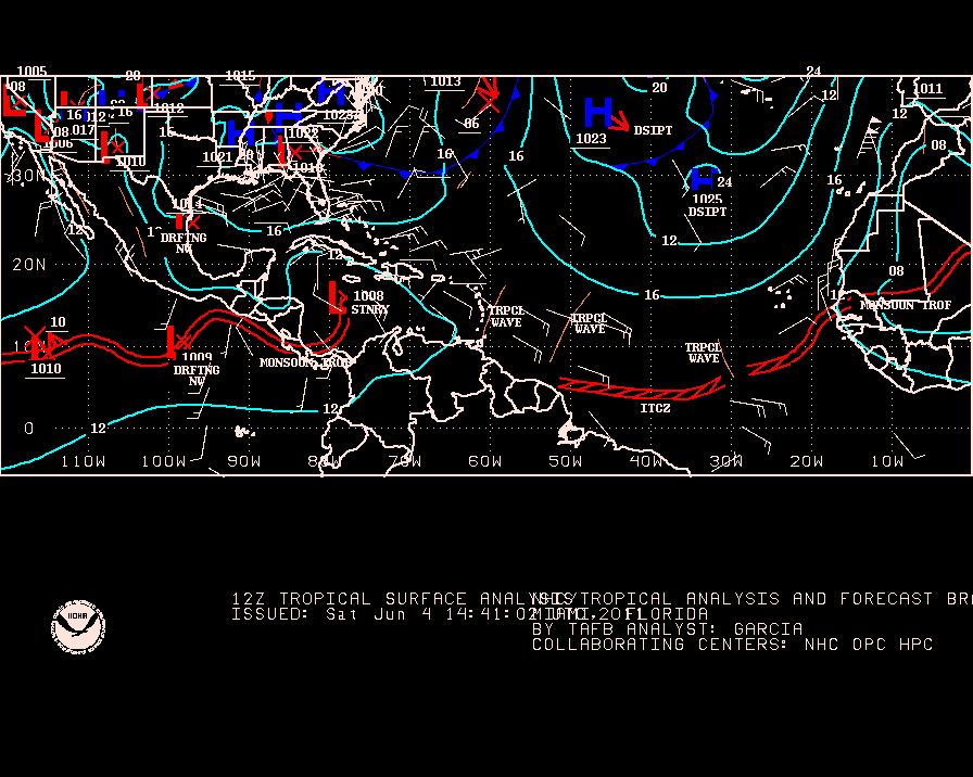
RL3AO wrote:wxman57 wrote:Just keep an eye on the continuity from day to day. Waves don't generally just dissipate (like #3 along 73W). They're just harder to identify at times.
Heres what the TWD said for wave 3
TROPICAL WAVE THAT IS INLAND OVER COLOMBIA ALONG 72W/73W S OF
13N HAS MOVED INTO AN AREA OF LOWER PRESSURE AND HAS BEEN
DROPPED FROM THE SURFACE ANALYSIS.
I'll bet that it'll be identifiable again once it moves into the East Pac. Just because it's harder to see doesn't mean it's gone. In fact, #3 appears to be the feature that's helping to enhance convection in the SW Caribbean along 78-79W today. I can see it moving westward through that area.
0 likes


-
cycloneye

- Admin

- Posts: 149777
- Age: 69
- Joined: Thu Oct 10, 2002 10:54 am
- Location: San Juan, Puerto Rico
Re: 2011 Tropical Waves
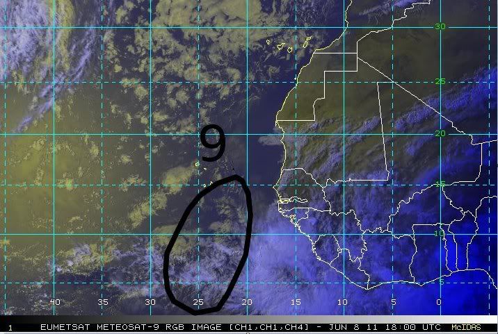
Tropical Wave #9 Introduced at 18z

Uploaded by imageshack.us
Uploaded by imageshack.us
0 likes
Visit the Caribbean-Central America Weather Thread where you can find at first post web cams,radars
and observations from Caribbean basin members Click Here
and observations from Caribbean basin members Click Here


-
cycloneye
- Admin
- Posts: 149777
- Age: 69
- Joined: Thu Oct 10, 2002 10:54 am
- Location: San Juan, Puerto Rico
Re: 2011 Tropical Waves
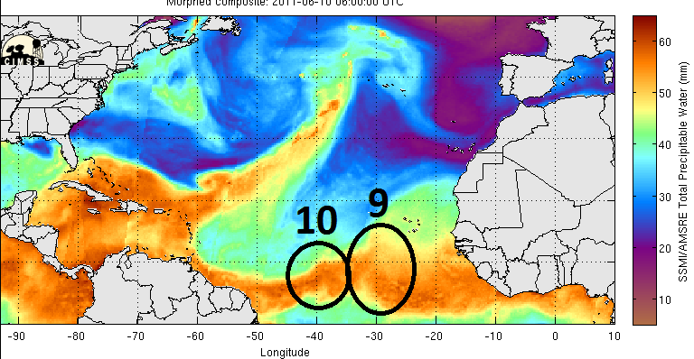
Tropical Wave 10 introduced at 06z
Near 40W.

Near 40W.
0 likes
Visit the Caribbean-Central America Weather Thread where you can find at first post web cams,radars
and observations from Caribbean basin members Click Here
and observations from Caribbean basin members Click Here
Re: 2011 Tropical Waves
cycloneye wrote:Tropical Wave #9 Introduced at 18z
Uploaded by imageshack.us

0 likes

-
Dean4Storms
- S2K Supporter

- Posts: 6358
- Age: 63
- Joined: Sun Aug 31, 2003 1:01 pm
- Location: Miramar Bch. FL


Re: 2011 Tropical Waves
Its probably related. The actual wave is a bit ahead of the convection.
0 likes
Re: 2011 Tropical Waves
The wave added yesterday near Panama might be wave 8. I'll have to look into it more.
0 likes

Re: 2011 Tropical Waves
bvigal wrote:How did #10 get ahead of #9, did he run over him?
Only thing I think of is that the one behind (further east, #9) was introduced before the one ahead (#10) showed its signature...
0 likes
Re: 2011 Tropical Waves
TheBurn wrote:bvigal wrote:How did #10 get ahead of #9, did he run over him?
Only thing I think of is that the one behind (further east, #9) was introduced before the one ahead (#10) showed its signature...
Correct.
0 likes
-
Dean4Storms
- S2K Supporter
- Posts: 6358
- Age: 63
- Joined: Sun Aug 31, 2003 1:01 pm
- Location: Miramar Bch. FL
-
cycloneye
- Admin
- Posts: 149777
- Age: 69
- Joined: Thu Oct 10, 2002 10:54 am
- Location: San Juan, Puerto Rico
Re: 2011 Tropical Waves
Wave #11 Introduced on 6/14/11 at 00z around 20W

Uploaded by imageshack.us
Uploaded by imageshack.us
0 likes
Visit the Caribbean-Central America Weather Thread where you can find at first post web cams,radars
and observations from Caribbean basin members Click Here
and observations from Caribbean basin members Click Here

Re: 2011 Tropical Waves
FIM is showing a pretty good amplitude wave south of PR on Sunday with strong latent heat flux.
At this point, CAPE looks moderate at about 1500.
Need to watch and see if shear clears out by then.
Dynamic tropopause is forecast to be relatively high at somewhere around 370 to 380K.
The whole Carib and west GOM will be caught up in a UL High by then.


At this point, CAPE looks moderate at about 1500.
Need to watch and see if shear clears out by then.
Dynamic tropopause is forecast to be relatively high at somewhere around 370 to 380K.
The whole Carib and west GOM will be caught up in a UL High by then.
0 likes
Who is online
Users browsing this forum: No registered users and 205 guests