
Possible Subtropical Cyclone near the Azores
Moderator: S2k Moderators
Forum rules

The posts in this forum are NOT official forecasts and should not be used as such. They are just the opinion of the poster and may or may not be backed by sound meteorological data. They are NOT endorsed by any professional institution or STORM2K. For official information, please refer to products from the National Hurricane Center and National Weather Service.
-
cycloneye

- Admin

- Posts: 148741
- Age: 69
- Joined: Thu Oct 10, 2002 10:54 am
- Location: San Juan, Puerto Rico
Re: Possible Subtropical Cyclone near the Azores
The 18 UTC Surface analysis has the low with the lowest pressure of 1001 mbs.
0 likes
-
Ed Mahmoud
Re: Possible Subtropical Cyclone near the Azores
Not a lot of deep convection, it is over waters way too cool for tropical development, and it has occluded completely, meaning it has little connection left to 'warm sector' air.
And the GFS weakens it substantially.

But I am always open to being surprised.
And the GFS weakens it substantially.
But I am always open to being surprised.
0 likes
-
cycloneye
- Admin
- Posts: 148741
- Age: 69
- Joined: Thu Oct 10, 2002 10:54 am
- Location: San Juan, Puerto Rico
Re: Possible Subtropical Cyclone near the Azores
This pass was made at 4:10 PM EDT so is not very old.It did not got ther whole circulation

0 likes
-
Ed Mahmoud
Re: Possible Subtropical Cyclone near the Azores
IMHO, the only thing lacking for a fairly rapid transition to a warm core system that would persist and even strengthen is ocean temps a few degrees too cool.
But I don't think it will sustain the convection needed to maintain and strengthen.
In my amateur opinion, of course.
But I don't think it will sustain the convection needed to maintain and strengthen.
In my amateur opinion, of course.
0 likes
-
DanieleItalyRm
- Category 1

- Posts: 487
- Age: 39
- Joined: Mon Sep 22, 2008 7:52 am
- Location: Rome - Italy - Mediterranean sea
Re: Possible Subtropical Cyclone near the Azores
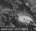
Tempesta con caratteristiche tropicali poco a nord delle Isole Azzorre, con evidente warm core a 850 hpa.
Con venti fino a 40 nodi ha un intensita' stimabile come tempesta tropicale (sebbene il Quickscat mostra i venti alle 13, dunque qualche ora prima la formazone dell'occhio della tempesta);
Molte le similitudini di formazione con l'Uragano Vince (2005) ma in questo periodo la superficie marina è ancor piu' fredda.
La formazione dell'occhio è stata comunque molto interessante, pari a TLC e cicloni tropicali. La pressione segnata da gfs è di 1005 hpa. In realta', come spesso capita,il ciclone è molto piccolo per essere identificato bene dal modello europeo. L'isola di Graciosa, ad esempio, ha segnato una pressione di 1000 hpa, stimo dunque una pressione reale di circa 996-998 Hpa nel centro.


http://www.sat24.com/
Last edited by DanieleItalyRm on Mon Jun 01, 2009 6:40 pm, edited 2 times in total.
0 likes
-
Category 5

- Category 5

- Posts: 10074
- Age: 35
- Joined: Sun Feb 11, 2007 10:00 pm
- Location: New Brunswick, NJ
- Contact:
Re: Possible Subtropical Cyclone near the Azores
It looks like we might have possibly had an STS earlier. Maybe NHC looks at it post season.
0 likes
-
cycloneye
- Admin
- Posts: 148741
- Age: 69
- Joined: Thu Oct 10, 2002 10:54 am
- Location: San Juan, Puerto Rico
Re: Possible Subtropical Cyclone near the Azores
NHC is taking notice of this.
068
ABNT20 KNHC 012355
TWOAT
TROPICAL WEATHER OUTLOOK
NWS TPC/NATIONAL HURRICANE CENTER MIAMI FL
800 PM EDT MON JUN 1 2009
FOR THE NORTH ATLANTIC...CARIBBEAN SEA AND THE GULF OF MEXICO...
A NON-TROPICAL AREA OF LOW PRESSURE LOCATED A COUPLE HUNDRED MILES
NORTH-NORTHEAST OF THE AZORES ISLANDS IS PRODUCING WINDS TO NEAR
GALE FORCE. SHOWERS AND THUNDERSTORMS ASSOCIATED WITH THE LOW HAVE
BECOME A LITTLE LESS ORGANIZED DURING THE PAST FEW HOURS. THIS
SYSTEM IS EXPECTED TO MOVE NORTHWARD OVER COOLER WATERS DURING THE
NEXT DAY OR TWO. THERE IS A LOW CHANCE...LESS THAN 30 PERCENT...OF
THIS SYSTEM BECOMING A SUBTROPICAL CYCLONE DURING THE NEXT 48
HOURS.
ELSEWHERE...TROPICAL CYCLONE FORMATION IS NOT EXPECTED DURING THE
NEXT 48 HOURS.
$$
FORECASTER BROWN
http://www.storm2k.org/weather/hw3.php? ... hwvmetric=
0 likes


-
DanieleItalyRm
- Category 1
- Posts: 487
- Age: 39
- Joined: Mon Sep 22, 2008 7:52 am
- Location: Rome - Italy - Mediterranean sea
Re: Possible Subtropical Cyclone near the Azores
Guardate i loop:
http://www.sat24.com/Region.aspx?countr ... &type=loop
http://wind.met.fu-berlin.de/cgi-bin/meteosat.cgi?speed (click Anzahl 36h)
this is not EC
http://www.sat24.com/Region.aspx?countr ... &type=loop
http://wind.met.fu-berlin.de/cgi-bin/meteosat.cgi?speed (click Anzahl 36h)
this is not EC
0 likes
-
cycloneye
- Admin
- Posts: 148741
- Age: 69
- Joined: Thu Oct 10, 2002 10:54 am
- Location: San Juan, Puerto Rico
Re: Possible Subtropical Cyclone near the Azores
Lets continue the discussions about this system at active storms forum because this is now invest 92L.
Link to thread at Active Storms forum.Thread is locked.
viewtopic.php?f=59&t=105448&p=1882363#p1882363
Link to thread at Active Storms forum.Thread is locked.
viewtopic.php?f=59&t=105448&p=1882363#p1882363
0 likes
Who is online
Users browsing this forum: No registered users and 63 guests