
Possible subtropical development on EC
Moderator: S2k Moderators
Forum rules

The posts in this forum are NOT official forecasts and should not be used as such. They are just the opinion of the poster and may or may not be backed by sound meteorological data. They are NOT endorsed by any professional institution or STORM2K. For official information, please refer to products from the National Hurricane Center and National Weather Service.
-
cycloneye

- Admin

- Posts: 148741
- Age: 69
- Joined: Thu Oct 10, 2002 10:54 am
- Location: San Juan, Puerto Rico
Re: Possible subtropical development on EC
12z CMC has a weak low making landfall at outerbanks in 48 hours.
0 likes


-
vacanechaser

- Category 5

- Posts: 1461
- Joined: Wed Dec 03, 2003 9:34 pm
- Location: Portsmouth, Va
- Contact:
Re: Possible subtropical development on EC
clearly a spin taking shape... does not look lke it is at the surface right now... but it is certainly taking shape... nice blow up over it too...
Jesse V. Bass III
http://www.vastormphoto.com
Hurricane Intercept Research Team
Jesse V. Bass III
http://www.vastormphoto.com
Hurricane Intercept Research Team
0 likes


-
TropicalWXMA

- Tropical Storm

- Posts: 114
- Joined: Wed May 18, 2005 9:22 pm
- Location: Boston, MA
- Contact:

Re:
Aric Dunn wrote:yeah keep an eye on this area today.. there some interesting aspects to this system..
sst's are marginal along the path..
gulf stream near north and south carolina are mid to maybe upper 70's in some spots..
if it stays farther west more of a chance, gulf stream is warmer..
Diamond Shoals is 78 http://www.ndbc.noaa.gov/station_page.php?station=41025
0 likes
-
Aric Dunn
- Category 5
- Posts: 21238
- Age: 43
- Joined: Sun Sep 19, 2004 9:58 pm
- Location: Ready for the Chase.
- Contact:
Re: Re:
xironman wrote:Aric Dunn wrote:yeah keep an eye on this area today.. there some interesting aspects to this system..
sst's are marginal along the path..
gulf stream near north and south carolina are mid to maybe upper 70's in some spots..
if it stays farther west more of a chance, gulf stream is warmer..
Diamond Shoals is 78 http://www.ndbc.noaa.gov/station_page.php?station=41025
yep thats plenty ... for sub trop and tropical if its moving a little faster..
0 likes
-
Tampa Bay Hurricane

- Category 5
- Posts: 5598
- Age: 38
- Joined: Fri Jul 22, 2005 7:54 pm
- Location: St. Petersburg, FL
-
brunota2003

- S2K Supporter

- Posts: 9476
- Age: 35
- Joined: Sat Jul 30, 2005 9:56 pm
- Location: Stanton, KY...formerly Havelock, NC
- Contact:
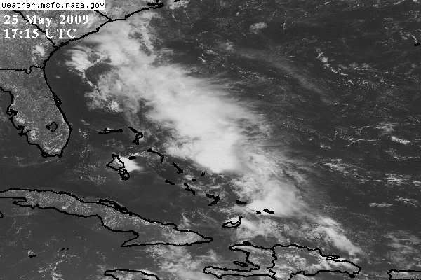
Re: Possible subtropical development on EC
Well, QuikScat does not currently show any closed circulation, however, there are a couple of 50 knot barbs that are not blacked out (meaning possible rain contamination if they are blacked out) just to the east of the islands:

I do not know if there is actual surface winds that strong, but the fact that there are two barbs indicating 50 knot winds (estimated) is interesting nonetheless.
I do not know if there is actual surface winds that strong, but the fact that there are two barbs indicating 50 knot winds (estimated) is interesting nonetheless.
0 likes
-
cycloneye
- Admin
- Posts: 148741
- Age: 69
- Joined: Thu Oct 10, 2002 10:54 am
- Location: San Juan, Puerto Rico
Re: Possible subtropical development on EC
0 likes
-
brunota2003
- S2K Supporter
- Posts: 9476
- Age: 35
- Joined: Sat Jul 30, 2005 9:56 pm
- Location: Stanton, KY...formerly Havelock, NC
- Contact:
Re: Possible subtropical development on EC
cycloneye wrote::uarrow: That pass was made at 6:58 AM EDT (Look at number at the bottom) Tonights pass will have more answers to what is really going on there..
Glad someone knows how to read the numbers
0 likes
-
catastrophic
- Tropical Low

- Posts: 35
- Joined: Wed Jul 23, 2008 1:50 pm
- Location: palm bay FL

-
wxman57

- Moderator-Pro Met

- Posts: 23127
- Age: 68
- Joined: Sat Jun 21, 2003 8:06 pm
- Location: Houston, TX (southwest)
Re: Possible subtropical development on EC
There are a number of surface obs in the region. All are from the southeast at 15-20 kts. Surface pressures there in the 1013-1015mb range. Definitely no turning at the surface, and I don't see much aloft. Just an area to keep an eye on. Threat is minimal. Could cause a few thunderstorms across the Outer Banks of NC on Wednesday, that's about it.
0 likes
-
cycloneye
- Admin
- Posts: 148741
- Age: 69
- Joined: Thu Oct 10, 2002 10:54 am
- Location: San Juan, Puerto Rico
Re: Possible subtropical development on EC
From the TWD at 8 PM EDT:
ATLANTIC OCEAN...
SCATTERED SHOWERS AND THUNDERSTORMS ARE OCCURRING N OF 24N W OF
70W INCLUDING THE NW BAHAMAS AND ADJACENT INLAND LOCATIONS OF
FLORIDA...AS WELL AS S OF 24N W OF 67W INCLUDING PORTIONS OF
CUBA...HISPANIOLA...PUERTO RICO...AND THE SE BAHAMAS. THIS
ACTIVITY IS BEING SUPPORTED BY LOW LEVEL CONVERGENCE NEAR A
SURFACE TROUGH NEAR THE BAHAMAS EXTENDING FROM 25N76W TO 23N75W
TO 21N74W. THE SURFACE TROUGH IS FORECAST TO MOVE TOWARD THE
NORTH TO NORTHEAST DURING THE NEXT COUPLE OF DAYS...WITH THE
POTENTIAL FOR AN INCREASING SURFACE PRESSURE GRADIENT E OF THE
TROUGH. THE SHOWER AND THUNDERSTORM ACTIVITY IS ALSO BEING
SUPPORTED BY UPPER LEVEL DIFFLUENCE IN MOIST SOUTHWESTERLY FLOW
ALOFT BETWEEN AN UPPER LEVEL TROUGH OVER THE N GULF OF MEXICO
AND AN UPPER LEVEL RIDGE ACROSS THE SW NORTH ATLC
http://www.storm2k.org/weather/hw3.php? ... hwvmetric=
0 likes
Who is online
Users browsing this forum: No registered users and 63 guests