Late Season Development W. Carib. (Is invest 91L)

This is the general tropical discussion area. Anyone can take their shot at predicting a storms path.

Moderator: S2k Moderators

Forum rules

The posts in this forum are NOT official forecasts and should not be used as such. They are just the opinion of the poster and may or may not be backed by sound meteorological data. They are NOT endorsed by any professional institution or STORM2K. For official information, please refer to products from the National Hurricane Center and National Weather Service.

Help Support Storm2K
Message
Author
jinftl
Category 5
Category 5
Posts: 4312
Joined: Tue Aug 31, 2004 4:47 pm
Location: fort lauderdale, fl

Re: Late Season Development W. Carib. GFS & EURO

#21 Postby jinftl » Fri Oct 17, 2008 4:35 pm

So far out there are no certainties anything will materialize.....but that said, this is clearly 'the area' to watch for development, esp. if something is going to effect us here in florida for the remainder of the season.

We are 1 week away from the 3-year anniversary of wilma here in south florida...october 24, 2005. History is not likely to repeat itself....but always keeping one eye open, esp. when some model support exists for development in time.

HURAKAN wrote:Accuweather:

Image

Image
0 likes   

User avatar
HURAKAN
Professional-Met
Professional-Met
Posts: 46086
Age: 38
Joined: Thu May 20, 2004 4:34 pm
Location: Key West, FL
Contact:

#22 Postby HURAKAN » Fri Oct 17, 2008 4:58 pm

Image

This is an area to look for development.
0 likes   

Rainband

Re: Late Season Development W. Carib. GFS & EURO

#23 Postby Rainband » Fri Oct 17, 2008 7:07 pm

yea in the epac
0 likes   

Sanibel
Category 5
Category 5
Posts: 10375
Joined: Mon Aug 30, 2004 11:06 pm
Location: Offshore SW Florida

Re: Late Season Development W. Carib. GFS & EURO

#24 Postby Sanibel » Fri Oct 17, 2008 9:59 pm

Oklahoma trough pushing east now. Could kick TD16 remnants N?
0 likes   

User avatar
boca
Category 5
Category 5
Posts: 6368
Age: 60
Joined: Mon Dec 15, 2003 8:49 am
Location: Boca Raton,FL

Re: Late Season Development W. Carib. GFS & EURO

#25 Postby boca » Fri Oct 17, 2008 10:54 pm

Rainband wrote:yea in the epac


I agree if something gonna pop it will be in the EPAC.Sanibel I usually agree with you on 95% of your posts but the only thing this Oklahoma trough is going to do is pull its chain.Its already getting sheared apart. Now if something gets going down there next week the trough will be a lot deeper so it will pull whatever gets going down there northward.If the GFS is right of course.
0 likes   

jinftl
Category 5
Category 5
Posts: 4312
Joined: Tue Aug 31, 2004 4:47 pm
Location: fort lauderdale, fl

Re: Late Season Development W. Carib. GFS & EURO

#26 Postby jinftl » Fri Oct 17, 2008 11:16 pm

Excerpt from Dr. Jeff Master's blog on 10/17/08:

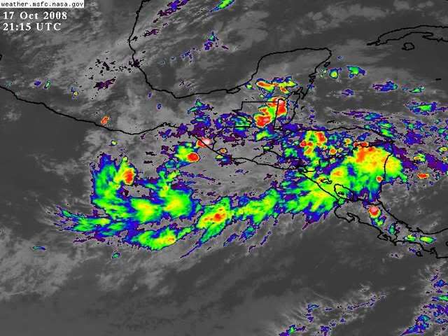
Several computer models are predicting the development of a tropical depression in the Atlantic's southwestern Caribbean, off the coast of Nicaragua or Honduras, about 5-8 days from now. Wind shear is expected to be low, 5-10 knots, across most of the Caribbean for the next ten days, and I would not be surprised to see a tropical storm develop in the Caribbean next week.

Heavy rains continue over the Central American nations of Honduras, Nicaragua, Costa Rica, Guatemala, and El Salvador, in association with the remains of Tropical Depression Sixteen. The remains of TD 16 could move over the Eastern Pacific and regenerate into a tropical storm. Several of the computer models continue to indicate this possibility, and NHC is giving this system a medium (20-50% chance) of becoming a tropical depression in the Eastern Pacific by Sunday.


http://www.wunderground.com/blog/JeffMasters/comment.html?entrynum=1130&tstamp=200810
0 likes   

User avatar
boca
Category 5
Category 5
Posts: 6368
Age: 60
Joined: Mon Dec 15, 2003 8:49 am
Location: Boca Raton,FL

Re: Late Season Development W. Carib. GFS & EURO

#27 Postby boca » Fri Oct 17, 2008 11:28 pm

Jinftl, if that is true then we have to see which storm will be the dominate one.Old td#16 in EPAC or are newly model formed sytem for next week.
0 likes   

Ed Mahmoud

Re: Late Season Development W. Carib. GFS & EURO

#28 Postby Ed Mahmoud » Fri Oct 17, 2008 11:58 pm

new GFS still develops a tropical system and drags it towards Florida.

Now, does it get sheared apart (if GFS is correct in general set-up) or baroclinic enhancement to beat the band as it approaches Florida, as that upper low moving East from the Plains has 1000-500 mb thicknesses below 540 dm. (See my excitement on EWG's thread on Plains cold front where I speculate about snow in Kansas)?

Image
0 likes   

User avatar
blp
Category 5
Category 5
Posts: 2841
Age: 46
Joined: Thu Sep 09, 2004 7:51 pm
Location: Miami, FL
Contact:

Re: Late Season Development W. Carib. GFS & EURO

#29 Postby blp » Sat Oct 18, 2008 2:17 am

00Z CMC is more aggressive now with development, not much of a surprise considering its bias for development. 00Z Euro seems to have lost it again.

144hr CMC
Image
0 likes   

jinftl
Category 5
Category 5
Posts: 4312
Joined: Tue Aug 31, 2004 4:47 pm
Location: fort lauderdale, fl

Re: Late Season Development W. Carib. GFS & CMC

#30 Postby jinftl » Sat Oct 18, 2008 4:49 am

Excerpt from NWS Miami Discussion....
NATIONAL WEATHER SERVICE MIAMI FL
420 AM EDT SAT OCT 18 2008
DISCUSSION...

THEN THE FCST BECOMES HIGHLY UNCERTAIN FOR
WEDNESDAY AND BEYOND. GFS CONTINUES TO BRING A LOW NORTH INTO THE
GULF BRINGING COPIOUS MOISTURE TO THE AREA BY WED...WITH PWATS
SURGING OVER 2 INCHES...THEN IT HAS THE LOW MOVING ACROSS THE FL
PENINSULA BY FRIDAY
.


Excerpt from NWS Key West Discussion...
NATIONAL WEATHER SERVICE KEY WEST FL
330 AM EDT SAT OCT 18 2008
DISCUSSION...

BY NEXT WEEK...THE KEYS AND SURROUNDING WATERS AGAIN WILL SEE
THE RETURN OF MODERATE TO OCCASIONALLY FRESH EAST BREEZES. AS HAS
BEEN STATED OVER THE PAST FEW FORECAST CYCLES.

THE GFS SOLUTION HAS BEEN ERRATIC AS FAR AS THE LOW PRESSURE
LIFTING OUT OF THE WESTERN CARIBBEAN IS CONCERNED.
THIS LATEST RUN PULLS A DEFINED LOW (BUT
WEAKER THAN PREVIOUS RUNS) OUT OF THE YUCATAN CHANNEL ACROSS
SOUTHWESTERN FLORIDA FROM LATE WEDNESDAY THROUGH EARLY FRIDAY.
THE
ECMWF REMAINS CONSISTENT TO PREVIOUS RUNS...KEEPING WEAKER LOW
SURFACE PRESSURE CONFINED TO THE WESTERN CARIBBEAN AND SHUNTING THE
DEEPER MOISTURE IN THOSE LATITUDES.


Excerpt from NWS Tampa Bay Discussion...
NATIONAL WEATHER SERVICE TAMPA BAY RUSKIN FL
132 AM EDT SAT OCT 18 2008

.SYNOPSIS....LONG TERM (MONDAY NIGHT-FRIDAY). MODELS CONTINUE TO
DIVERGE ON LONG TERM SOLUTION. SILL LEANING TOWARD GFS TYPE
SOLUTION WITH LOW PRESSURE DEVELOPING ALONG THE TAIL END OF A
FRONTAL BOUNDARY WHICH WILL BE SOUTH OF THE AREA
. HOWEVER...TOO
EARLY TO DETERMINE WHERE SURFACE LOW WOULD FORM AND EVENTUALLY
TRACK. WILL INDICATE INCREASED MOISTURE THURSDAY AND FRIDAY WITH A
CHANCE OF SHOWERS AS FRONTAL BOUNDARY LIFTS NORTH ACROSS THE
REGION. TEMPERATURES WILL RUN NEAR NORMAL TO SLIGHTLY ABOVE NORMAL
THURSDAY AND FRIDAY. WILL CONTINUE TO MONITOR CONSISTENCIES IN
MODELS RUN-TO-RUN FOR THE NEXT COUPLE OF DAYS.
0 likes   

User avatar
HURAKAN
Professional-Met
Professional-Met
Posts: 46086
Age: 38
Joined: Thu May 20, 2004 4:34 pm
Location: Key West, FL
Contact:

#31 Postby HURAKAN » Sat Oct 18, 2008 6:21 am

GFS
Image

CMC
Image
0 likes   

jinftl
Category 5
Category 5
Posts: 4312
Joined: Tue Aug 31, 2004 4:47 pm
Location: fort lauderdale, fl

Re: Late Season Development W. Carib. GFS & CMC

#32 Postby jinftl » Sat Oct 18, 2008 8:09 am

We don't need Paloma making her presence known anywhere....what's in a name? Nothing probably...but these are some excerpts from the 'hidden meanings' of the name "Paloma" I found on the internet (friend's myspace quiz...all in good fun, not to be taken as a forecast or prediction...but 144 hours out from even anything developing, there is only so much to speculate on for now)

What Paloma Means:

You are influential and persuasive. You tend to have a lot of power over people.
Generally, you use your powers for good. You excel at solving other people's problems.
Occasionally, you do get a little selfish and persuade people to do things that are only in your interest.

At times, you can be a bit too serious. You tend to put too much pressure on yourself.

You are confident, self assured, and capable. You are not easily intimidated.
You master any and all skills easily. You don't have to work hard for what you want.
You make your life out to be exactly how you want it. And you'll knock down anyone who gets in your way!
0 likes   

User avatar
Blown Away
S2K Supporter
S2K Supporter
Posts: 10154
Joined: Wed May 26, 2004 6:17 am

Re: Late Season Development W. Carib. GFS & CMC

#33 Postby Blown Away » Sat Oct 18, 2008 8:12 am

:uarrow: Sounds like at Cat 3 storm.
0 likes   

User avatar
Lowpressure
S2K Supporter
S2K Supporter
Posts: 2032
Age: 58
Joined: Sun Sep 14, 2003 9:17 am
Location: Charlotte, North Carolina

Re: Late Season Development W. Carib. GFS & CMC

#34 Postby Lowpressure » Sat Oct 18, 2008 8:28 am

Sounds like my wife
0 likes   

User avatar
gatorcane
S2K Supporter
S2K Supporter
Posts: 23692
Age: 47
Joined: Sun Mar 13, 2005 3:54 pm
Location: Boca Raton, FL

Re: Late Season Development W. Carib. GFS & CMC

#35 Postby gatorcane » Sat Oct 18, 2008 8:31 am

Well it does appear TD 16 has stalled and a surface low is lingering near belize just how the Euro and a couple of other models said it would. Despite some criticism from some mets on my thinking that something will linger in the Western/NW Caribbean sea, I'm glad I stuck with my forecast because it would appear it is verifying. I just couldn't see TD 16 get pushed far enough west to not have any possibility of its remnants getting pushed north at some point. Afterall we are in October and I do respect climatology.

Check it out, a surface low just east of Belize
Image

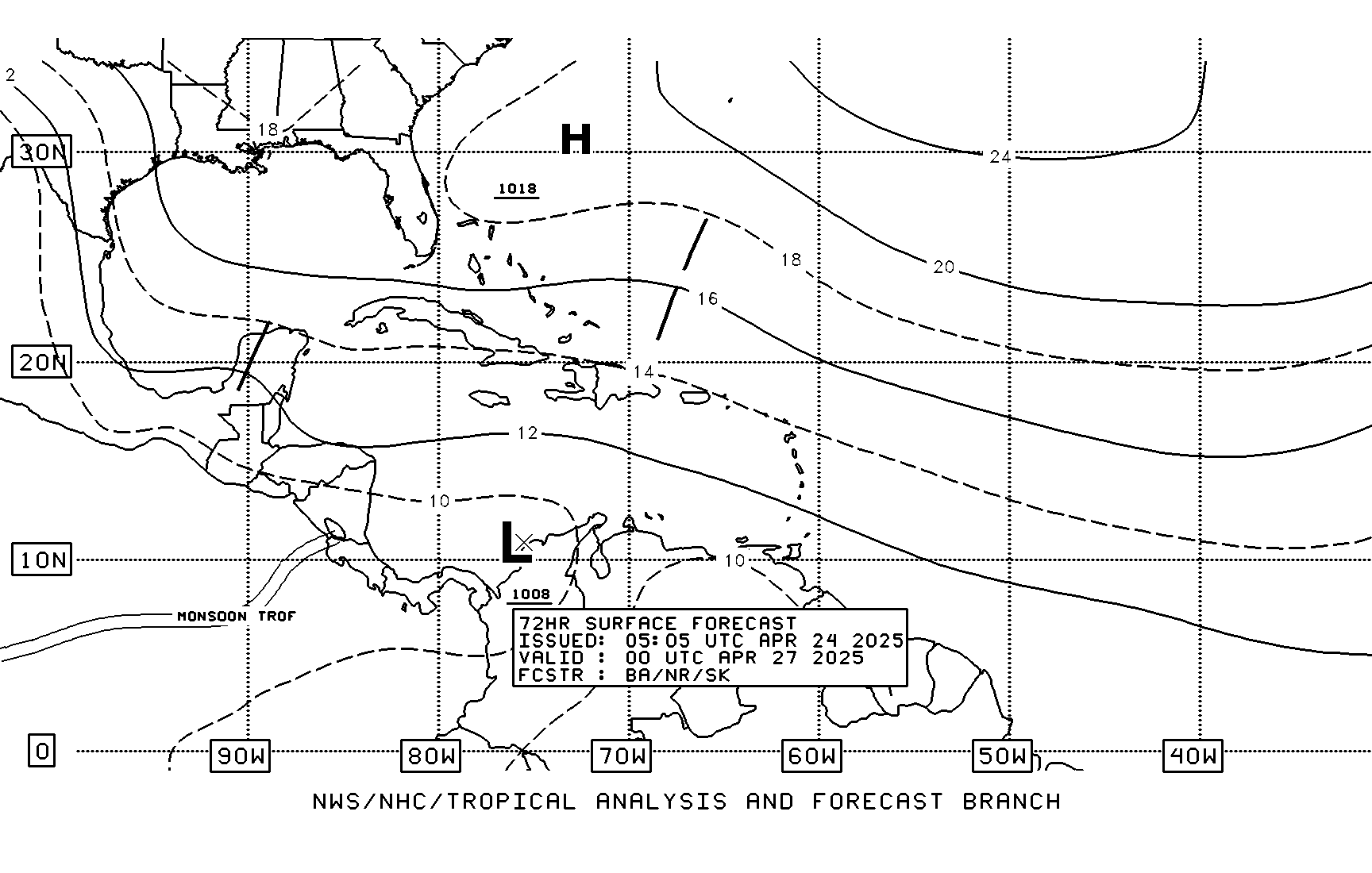
TAFB 72 hour forecast, the low will be in prime time area in the NW Caribbean.
Image

Note the cold front off to the NW....as for the future for this area it does bear watching for sure,but development will be gradual and it may take until mid next week or so to see something significant crank up there. I do think something is likely going to spin up around where this surface low is at or a bit more east...
0 likes   

User avatar
HURAKAN
Professional-Met
Professional-Met
Posts: 46086
Age: 38
Joined: Thu May 20, 2004 4:34 pm
Location: Key West, FL
Contact:

#36 Postby HURAKAN » Sat Oct 18, 2008 8:39 am

If this system develops, after so many days since TD 16 dissipated, will it still be TD 16?

Image

Shear not a major problem.
0 likes   

MiamiensisWx

Re: Late Season Development W. Carib. GFS & CMC

#37 Postby MiamiensisWx » Sat Oct 18, 2008 8:42 am

It's quite plausible that the operational GFS is incorrect, as I have suspected that may be the case. Regardless, the operational GFS has gradually strayed from its original set-up in yesterday's 06Z run. In this case, the alterations make more sense because of the current pattern evolution. Originally, the operational GFS depicted a less amplified/more progressive 250-300 mb upper low (and associated vorticity maximum) over southeastern Canada, which contributed to a stronger 250-500 mb ridge to the SW; this resulted in a deeper upper low over the southern Plains. However, subsequent runs have caught on to the upcoming pattern change (including a weaker Pacific jet and -NAO set-up), so the upper low over the Canadian Maritimes lingered longer. As a result, the ridge to the SW and the upper low over the Midwest was weaker in recent runs. The implications are significant for any TC that enters the southern/SE Gulf of Mexico during the time frame.

The original set-up depicted by the operational GFS (06Z on October 17, 2008) showed wind vectors that were more backed (SSW) over the eastern Gulf of Mexico, unlike later runs. The pattern in the run suggested that any TC would take a path NE across southern Florida (like Isbell 1964). The orientation of the wind vectors (SSW) would have provided an excellent poleward outflow channel for an accelerating TC moving from SW/SSW to NE/NNE, and the fast movement/translational velocity of the TC would have reduced shear on the back side. In this situation, a TC would likely intensify over the SE Gulf of Mexico, as seen with Wilma 2005. It all depends on the speed of the TC and the orientation of the mid/upper level wind vectors in relation to the track of the TC.

Recent runs (as mentioned) have transitioned to more realistic solutions, which depict westerly wind vectors over the GOM and a flatter/weaker subtropical ridge over the Caribbean. In this scenario, any TC would be moving farther north, and the westerly/west-northwest wind vectors would induce considerable shear over the TC as it moves from SSW to NNE. Overall, if anything develops and (likely) moves toward the Florida peninsula/eastern GOM, it is very unlikely that it will exceed weak/moderate TS status, and it may likely evolve as a hybrid type system. There is a big difference between a strong TS/hurricane/major hurricane (especially if it is intensifying) and a stable/weakening weak/moderate TS. This event will not be a big issue if it even develops, in my view.

Overall, this event may provide some necessary precipitation before we enter the dry season (without strong winds of 55-60 kt or greater). The window for systems to affect the CONUS (and Florida) rapidly closes after October 25, so the clock is ticking.

The "season" for the CONUS may be over after this one, pending an anomalous strike in November...
0 likes   

User avatar
HURAKAN
Professional-Met
Professional-Met
Posts: 46086
Age: 38
Joined: Thu May 20, 2004 4:34 pm
Location: Key West, FL
Contact:

#38 Postby HURAKAN » Sat Oct 18, 2008 8:51 am

Image
0 likes   

User avatar
gatorcane
S2K Supporter
S2K Supporter
Posts: 23692
Age: 47
Joined: Sun Mar 13, 2005 3:54 pm
Location: Boca Raton, FL

#39 Postby gatorcane » Sat Oct 18, 2008 9:19 am

Despite the energy from TD that is helping form the area in the NW Caribbean that may ultimately develop ---- it probably would not be considered TD 16.

Still give credit to the Euro and HWRF for showing this low meandering in the NW Caribbean for 10 days after it became TD 16 last week. It looks like those models will verify.
0 likes   

User avatar
gatorcane
S2K Supporter
S2K Supporter
Posts: 23692
Age: 47
Joined: Sun Mar 13, 2005 3:54 pm
Location: Boca Raton, FL

#40 Postby gatorcane » Sat Oct 18, 2008 9:22 am

06Z GFS shows a low passing through peninsula Florida from the NW Caribbean, very October-like here:

Image
0 likes   


Return to “Talkin' Tropics”

Who is online

Users browsing this forum: Google Adsense [Bot], jgh, Lizzytiz1, NotSparta, Tak5, weatherSnoop and 75 guests