https://www.tropicaltidbits.com/analysi ... 712&fh=240
I’m new to Storm2k so I hope I don’t get in trouble for posting this. I hope I posted the picture correctly. What I posted was the 12z Euro 240 mark which shows a 1007mb low right above Hispaniola. I wasn’t sure if this was 94L or something new but I felt it was interesting to post. This could be a one run fluke but since the euro is highly respected, I thought it would be interesting to watch if it keeps showing this.
2023 Global Model Runs Discussion (Out thru day 16)
Moderator: S2k Moderators
Forum rules

The posts in this forum are NOT official forecasts and should not be used as such. They are just the opinion of the poster and may or may not be backed by sound meteorological data. They are NOT endorsed by any professional institution or STORM2K. For official information, please refer to products from the National Hurricane Center and National Weather Service.
-
Weathertracker96
- Tropical Storm

- Posts: 150
- Joined: Mon Oct 16, 2023 3:41 pm
-
AJC3

- Admin

- Posts: 4156
- Age: 62
- Joined: Tue Aug 31, 2004 7:04 pm
- Location: Ballston Spa, New York
- Contact:
Re: 2023 Global Model Runs Discussion (Out thru day 16)
Weathertracker96 wrote:https://www.tropicaltidbits.com/analysis/models/?model=ec-fast®ion=atl&pkg=mslpa&runtime=2023101712&fh=240
I’m new to Storm2k so I hope I don’t get in trouble for posting this. I hope I posted the picture correctly. What I posted was the 12z Euro 240 mark which shows a 1007mb low right above Hispaniola. I wasn’t sure if this was 94L or something new but I felt it was interesting to post. This could be a one run fluke but since the euro is highly respected, I thought it would be interesting to watch if it keeps showing this.
Well, you won't get in trouble per se, but you will get a reminder not to hotlink to images.
https://www.storm2k.org/phpbb2/viewtopi ... 1&t=111217
What you need to do is navigate to the image that you want to show. Then save and upload it to an image hosting web site such as imgur.com. Then right click on the image, and copy that link into your post, and display it using either the [imgur] or [img] tag. It's pretty intuitive, but if you need help figuring out how to do this, just ask.
I think this is what you wanted to show...

4 likes

Re: 2023 Global Model Runs Discussion (Out thru day 16)
This looks interesting. We might not be done yet! 12z euro also has 94l heading west under a strong high end of the run. Gotta watch the front on that run. Does it make it all the way and protect us west of 75 from 94l or stall? the 18z GFS has stronger ridging actually but has a gap still where it goes north. CPC global hazards says not so fast with Oct being quiet in the Caribbean.

1 likes


Re: 2023 Global Model Runs Discussion (Out thru day 16)
AJC3 wrote:Weathertracker96 wrote:https://www.tropicaltidbits.com/analysis/models/?model=ec-fast®ion=atl&pkg=mslpa&runtime=2023101712&fh=240
I’m new to Storm2k so I hope I don’t get in trouble for posting this. I hope I posted the picture correctly. What I posted was the 12z Euro 240 mark which shows a 1007mb low right above Hispaniola. I wasn’t sure if this was 94L or something new but I felt it was interesting to post. This could be a one run fluke but since the euro is highly respected, I thought it would be interesting to watch if it keeps showing this.
Well, you won't get in trouble per se, but you will get a reminder not to hotlink to images.
https://www.storm2k.org/phpbb2/viewtopi ... 1&t=111217
What you need to do is navigate to the image that you want to show. Then save and upload it to an image hosting web site such as imgur.com. Then right click on the image, and copy that link into your post, and display it using either the [url] or [url] tag. It's pretty intuitive, but if you need help figuring out how to do this, just ask.
I think this is what you wanted to show...
https://i.imgur.com/pyHvpPB.png
I prefer postimages.org these days. Imgur now removes your images after a while if you don't sign up for an account, and has less ideal support for GIFs.
0 likes
TC naming lists: retirements and intensity
Most aggressive Advisory #1's in North Atlantic (cr. kevin for starting the list)
Most aggressive Advisory #1's in North Atlantic (cr. kevin for starting the list)
Re: 2023 Global Model Runs Discussion (Out thru day 16)
Euro still bringing a westward moving tropical cyclone towards FL under a high! Trof coming but probably not before it hits the east coast of FL. The GFS ensembles also has a strong member in a similar position turns north just before FL.

1 likes
Re: 2023 Global Model Runs Discussion (Out thru day 16)
Another wave will move into the Caribbean in day 6-7 range.
0 likes
Re: 2023 Global Model Runs Discussion (Out thru day 16)
zzzh wrote:Another wave will move into the Caribbean in day 6-7 range.
High pressure, summer like weather (minus the storms) also returns to my area with slightly above normal temps next week. Euro could be onto something if the pattern is more like august (just not as hot of temps.) West will have more trofs and lower pressures while we're above normal in the east.
Things could get interesting.
0 likes
-
ThunderForce

- Tropical Storm
- Posts: 208
- Age: 26
- Joined: Tue Sep 27, 2022 6:20 pm
- Location: Calhoun County, Florida
Re: 2023 Global Model Runs Discussion (Out thru day 16)
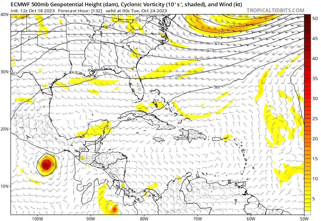
Whatever the Euro is showing doesn't appear to start off tropical in nature. Seems to come from a pinched off low pressure or vorticity moving off the East Coast of the US, that then moves southward to southwestward.
1 likes
Please refer to the NWS, NHC, SPC or a professional meteorologist for information and decision making during storms.
Re: 2023 Global Model Runs Discussion (Out thru day 16)
ThunderForce wrote:Whatever the Euro is showing doesn't appear to start off tropical in nature. Seems to come from a pinched off low pressure or vorticity moving off the East Coast of the US, that then moves southward to southwestward.
https://i.postimg.cc/hjVGf0Xs/ecmwf-z500-vort-watl-fh132-240.gif
High pressure building in, waters still hot in that area. That thing could blow up quick and hit from the east! Oh and GFS showing something similar but later on and from an MDR wave!!!
1 likes
-
ThunderForce
- Tropical Storm
- Posts: 208
- Age: 26
- Joined: Tue Sep 27, 2022 6:20 pm
- Location: Calhoun County, Florida
Re: 2023 Global Model Runs Discussion (Out thru day 16)
Ianswfl wrote:ThunderForce wrote:Whatever the Euro is showing doesn't appear to start off tropical in nature. Seems to come from a pinched off low pressure or vorticity moving off the East Coast of the US, that then moves southward to southwestward.
https://i.postimg.cc/hjVGf0Xs/ecmwf-z500-vort-watl-fh132-240.gif
High pressure building in, waters still hot in that area. That thing could blow up quick and hit from the east! Oh and GFS showing something similar but later on and from an MDR wave!!!
As usual, this is very much a "wait and see" scenario. It's beyond the 180 hour mark which is when things tend to shift a lot between runs. At the moment, Euro's EPS ensembles doesn't even have many if any ensembles showing support for a tropical cyclone/hurricane forming from the broad low the operational model shows.
Also, the low the GFS is showing in the Caribbean around the same timeframe has little to no vorticity associated with it right now either.
1 likes
Please refer to the NWS, NHC, SPC or a professional meteorologist for information and decision making during storms.
-
SFLcane

- S2K Supporter

- Posts: 10281
- Age: 48
- Joined: Sat Jun 05, 2010 1:44 pm
- Location: Lake Worth Florida
Re: 2023 Global Model Runs Discussion (Out thru day 16)
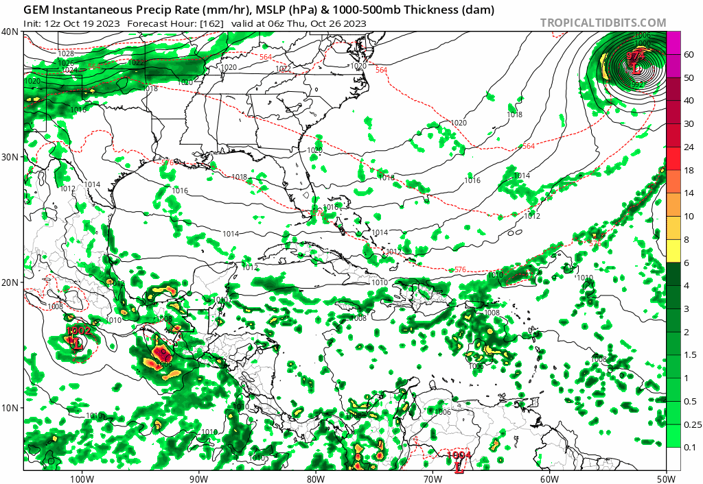
Potential hybrid heading for Florida on the Euro for my bday on the 28th… 
Nicole 2.0? Well see
Nicole 2.0? Well see
0 likes
-
Weathertracker96
- Tropical Storm
- Posts: 150
- Joined: Mon Oct 16, 2023 3:41 pm
Re: 2023 Global Model Runs Discussion (Out thru day 16)
SFLcane wrote:Potential hybrid heading for Florida on the Euro for my bday on the 28th…
Nicole 2.0? Well see
https://i.postimg.cc/BnkBfYww/IMG-7742.gif
Will be Interesting to see how this possibly comes together. Given it’s the euro and it’s not over 300 hours out, this has my attention. Will also be interesting if other models join in.
Happy Early Birthday as well.
1 likes
Re: 2023 Global Model Runs Discussion (Out thru day 16)
SFLcane wrote:Potential hybrid heading for Florida on the Euro for my bday on the 28th…
Nicole 2.0? Well see
https://i.postimg.cc/BnkBfYww/IMG-7742.gif
Or gordon 1994! However this is earlier than Nicole and waters will be a bit warmer. If it shoots for the keys it could get pretty strong still
0 likes

Re: 2023 Global Model Runs Discussion (Out thru day 16)
Ianswfl wrote:SFLcane wrote:Potential hybrid heading for Florida on the Euro for my bday on the 28th…
Nicole 2.0? Well see
https://i.postimg.cc/BnkBfYww/IMG-7742.gif
Or gordon 1994! However this is earlier than Nicole and waters will be a bit warmer. If it shoots for the keys it could get pretty strong still
The GFS is now showing this to a lesser extent as far as strength they are just showing a slight reflection.
0 likes
-
ThunderForce
- Tropical Storm
- Posts: 208
- Age: 26
- Joined: Tue Sep 27, 2022 6:20 pm
- Location: Calhoun County, Florida
Re: 2023 Global Model Runs Discussion (Out thru day 16)
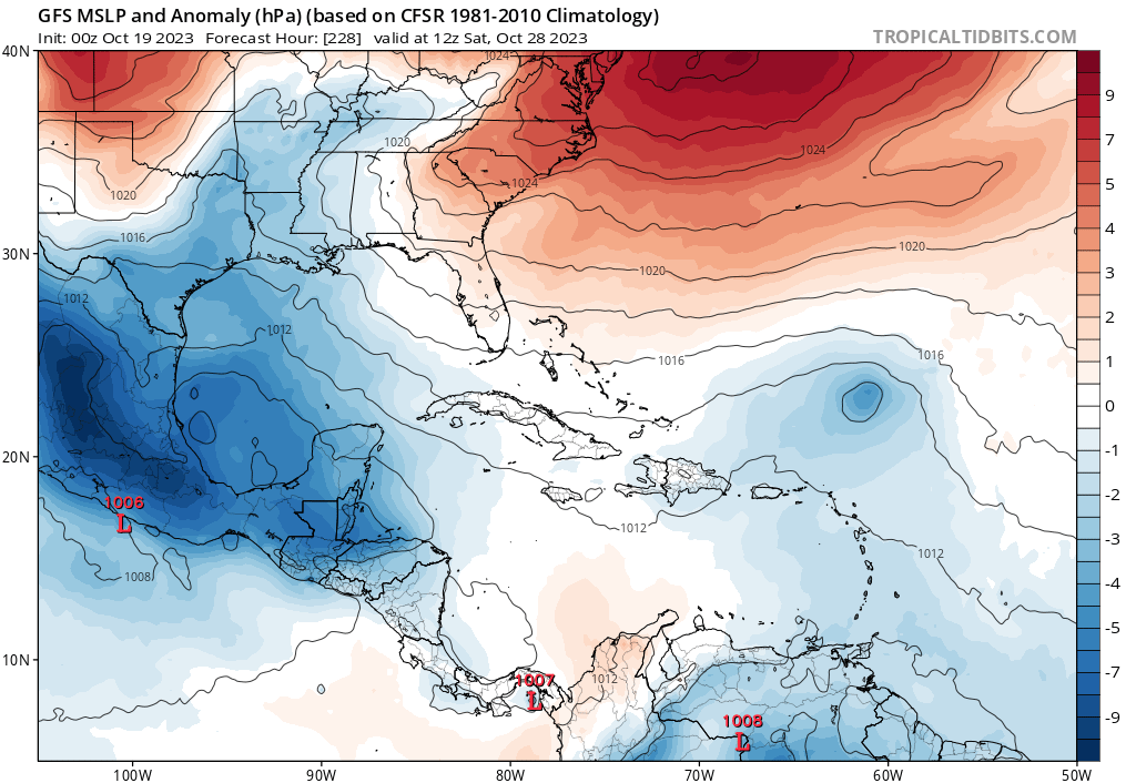
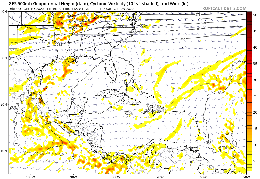
So, looking at the three major models (GFS, Euro, CMC/GEM) there are signals for three different systems after Tammy:
Southwest Caribbean System (Roughly October 23rd):
GEFS really wants to form something in this general area near Nicaragua in a few days. GFS shows the low pressure as well, but at the moment it goes into Central America before it gets a chance to develop much. CMC/GEM appears to show low pressure forming near here as well and moving westward. Euro and its ensembles have little to nothing, though.
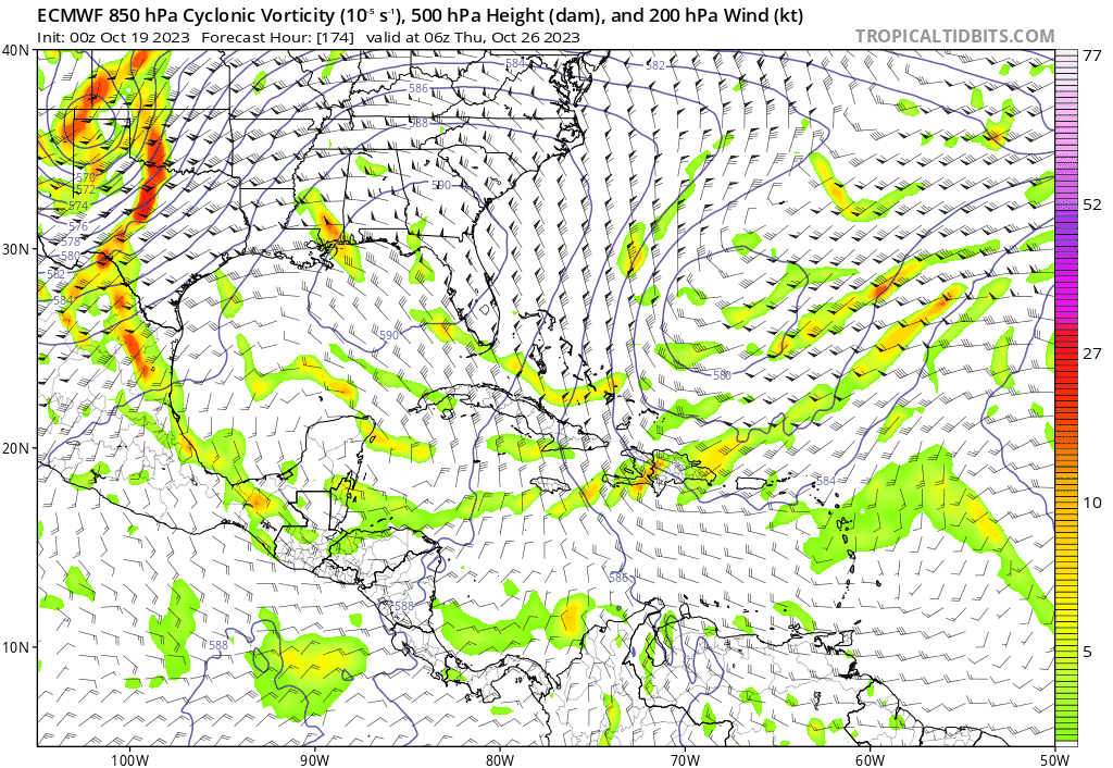
Subtropical(?) System (Appears in Caribbean roughly October 26th):
00z Euro shows vorticity coming off the East Coast and moving southward to southwestward near Haiti and the Dominican Republic, with what appears to be some possible development(?) as it then slowly moves westward to west-northwestward near the Bahamas, Florida and Cuba. 12z GFS jumped on this too with the last run, but features it splitting apart into separate vorticities or something later in the run. CMC/GEM doesn't seem to show this much?
At the moment, neither the GEFS or EPS ensembles seem to show this system much. Something to watch though.
CMC/GEM Tropical System (Roughly October 28th):
So far it seems only the CMC/GEM develops this much, and looking at the vorticity it seems to do it out of remnant vorticity and/or low pressure from the trough that picks up Tammy or Tammy itself (or possibly some sort of energy that came from the Cabo Verde Islands?). It doesn't appear to show up much if at all on Euro, and while GFS seems to show some low pressure near the same area, it gets sucked northward like Tammy before the pinched off low from the East Coast pops in.
Southwest Caribbean System (Roughly October 23rd):
GEFS really wants to form something in this general area near Nicaragua in a few days. GFS shows the low pressure as well, but at the moment it goes into Central America before it gets a chance to develop much. CMC/GEM appears to show low pressure forming near here as well and moving westward. Euro and its ensembles have little to nothing, though.
Subtropical(?) System (Appears in Caribbean roughly October 26th):
00z Euro shows vorticity coming off the East Coast and moving southward to southwestward near Haiti and the Dominican Republic, with what appears to be some possible development(?) as it then slowly moves westward to west-northwestward near the Bahamas, Florida and Cuba. 12z GFS jumped on this too with the last run, but features it splitting apart into separate vorticities or something later in the run. CMC/GEM doesn't seem to show this much?
At the moment, neither the GEFS or EPS ensembles seem to show this system much. Something to watch though.
CMC/GEM Tropical System (Roughly October 28th):
So far it seems only the CMC/GEM develops this much, and looking at the vorticity it seems to do it out of remnant vorticity and/or low pressure from the trough that picks up Tammy or Tammy itself (or possibly some sort of energy that came from the Cabo Verde Islands?). It doesn't appear to show up much if at all on Euro, and while GFS seems to show some low pressure near the same area, it gets sucked northward like Tammy before the pinched off low from the East Coast pops in.
1 likes
Please refer to the NWS, NHC, SPC or a professional meteorologist for information and decision making during storms.
Re: 2023 Global Model Runs Discussion (Out thru day 16)
12z euro ensembles more bullish on a system east of FL moving towards south FL maybe as a mid range cat1!
https://weather.us/cyclone-tracks/euro/ ... 2-240.html
https://weather.us/cyclone-tracks/euro/ ... 2-240.html
0 likes
Re: 2023 Global Model Runs Discussion (Out thru day 16)
Ianswfl wrote:12z euro ensembles more bullish on a system east of FL moving towards south FL maybe as a mid range cat1!
https://weather.us/cyclone-tracks/euro/ ... 2-240.html
I saw the run from 12z euro and the system looked much weaker and I couldn’t even see if a low pressure was associated with it.
0 likes
Re: 2023 Global Model Runs Discussion (Out thru day 16)
boca wrote:Ianswfl wrote:12z euro ensembles more bullish on a system east of FL moving towards south FL maybe as a mid range cat1!
https://weather.us/cyclone-tracks/euro/ ... 2-240.html
I saw the run from 12z euro and the system looked much weaker and I couldn’t even see if a low pressure was associated with it.
Operational also seems more like land interaction too.
The euro ensembles are a lot more bullish on it compared to yesterday though
0 likes
Re: 2023 Global Model Runs Discussion (Out thru day 16)
18z GFS ensembles pick up on it too now. Member takes it via the Straits, a cat3 and sends it curving back into SWFL as a weak cat2 weakening at landfall due to cooler water likely at the coast. Couple other weaker members into FL too.

0 likes
Who is online
Users browsing this forum: mixedDanilo.E, Ulf and 183 guests