https://x.com/AndyHazelton/status/2018745144728867143
2026 ENSO Updates
Moderator: S2k Moderators
Forum rules

The posts in this forum are NOT official forecasts and should not be used as such. They are just the opinion of the poster and may or may not be backed by sound meteorological data. They are NOT endorsed by any professional institution or STORM2K. For official information, please refer to products from the National Hurricane Center and National Weather Service.
-
cycloneye

- Admin

- Posts: 149686
- Age: 69
- Joined: Thu Oct 10, 2002 10:54 am
- Location: San Juan, Puerto Rico
Re: 2026 ENSO Updates: CPC probability of El Niño for ASO is up to 61%
2 likes
Visit the Caribbean-Central America Weather Thread where you can find at first post web cams,radars
and observations from Caribbean basin members Click Here
and observations from Caribbean basin members Click Here
-
cycloneye
- Admin
- Posts: 149686
- Age: 69
- Joined: Thu Oct 10, 2002 10:54 am
- Location: San Juan, Puerto Rico
Re: 2026 ENSO Updates: CPC probability of El Niño for ASO is up to 61%
1 likes
Visit the Caribbean-Central America Weather Thread where you can find at first post web cams,radars
and observations from Caribbean basin members Click Here
and observations from Caribbean basin members Click Here
-
cycloneye
- Admin
- Posts: 149686
- Age: 69
- Joined: Thu Oct 10, 2002 10:54 am
- Location: San Juan, Puerto Rico
Re: 2026 ENSO Updates
0 likes
Visit the Caribbean-Central America Weather Thread where you can find at first post web cams,radars
and observations from Caribbean basin members Click Here
and observations from Caribbean basin members Click Here
-
DorkyMcDorkface

- Category 5

- Posts: 1039
- Age: 28
- Joined: Mon Sep 30, 2019 1:32 pm
- Location: Mid-Atlantic
Re: 2026 ENSO Updates
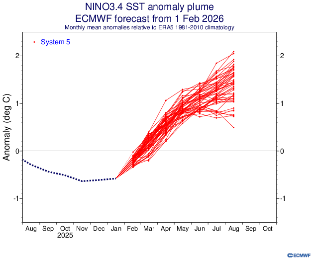
I know the seasonal Euro typically has a warm bias but this is a stronger forecast than Feb 2023, and that event ended up on the upper end of the general plume...

2 likes
Please note the thoughts expressed by this account are solely those of the user and are from a hobbyist perspective. For more comprehensive analysis, consult an actual professional meteorologist or meteorological agency.
Floyd 1999 | Isabel 2003 | Hanna 2008 | Irene 2011 | Sandy 2012 | Isaias 2020
-
cycloneye
- Admin
- Posts: 149686
- Age: 69
- Joined: Thu Oct 10, 2002 10:54 am
- Location: San Juan, Puerto Rico
Re: 2026 ENSO Updates
@AndyHazelton
ECMWF seasonal guidance continues to show El Niño quickly developing by summer. The main uncertainty at this point seems to be in the magnitude of the event (ensemble ranges from a weak/moderate event to a Super Niño).
On the Atlantic side, the SST configuration reminds me of 2021, with an Atlantic Niño forecast but warmth otherwise concentrated in the subtropics. The big difference is 2021 was a La Niña year, so I expect shear and subsidence will be a much bigger issue this year.
Consistent with this, the precip anomalies show a much drier than usual setup across the Atlantic MDR and Caribbean. Surface pressures are forecast to be higher than normal as well.
Overall, I continue to think (at this range) that we'll probably have an Atlantic hurricane season that struggles to reach average, and may even end up well below average (depending on how strong the El Niño is). Still a little ways to go, though.
https://x.com/AndyHazelton/status/2019400508419489910
0 likes
Visit the Caribbean-Central America Weather Thread where you can find at first post web cams,radars
and observations from Caribbean basin members Click Here
and observations from Caribbean basin members Click Here
-
cycloneye
- Admin
- Posts: 149686
- Age: 69
- Joined: Thu Oct 10, 2002 10:54 am
- Location: San Juan, Puerto Rico
Re: 2026 ENSO Updates
Will only say "yikes".


3 likes
Visit the Caribbean-Central America Weather Thread where you can find at first post web cams,radars
and observations from Caribbean basin members Click Here
and observations from Caribbean basin members Click Here
-
Iceresistance

- Category 5
- Posts: 9605
- Age: 22
- Joined: Sat Oct 10, 2020 9:45 am
- Location: Tecumseh, OK/Norman, OK
Re: 2026 ENSO Updates
cycloneye wrote:Will only say "yikes".
https://i.imgur.com/ECaAVY0.gif
https://i.imgur.com/lenK0BC.gif
It's one of those things that makes you go
Hopefully, that does limit the NATL season, but remember, all it takes is one!
3 likes
Bill 2015 & Beta 2020
Winter 2020-2021
All observations are in Tecumseh, OK unless otherwise noted.
Winter posts are focused mainly for Oklahoma & Texas.
Take any of my forecasts with a grain of salt, refer to the NWS, SPC, and NHC for official information
Never say Never with weather! Because ANYTHING is possible!
Winter 2020-2021
All observations are in Tecumseh, OK unless otherwise noted.
Winter posts are focused mainly for Oklahoma & Texas.
Take any of my forecasts with a grain of salt, refer to the NWS, SPC, and NHC for official information
Never say Never with weather! Because ANYTHING is possible!
-
cycloneye
- Admin
- Posts: 149686
- Age: 69
- Joined: Thu Oct 10, 2002 10:54 am
- Location: San Juan, Puerto Rico
Re: 2026 ENSO Updates
There are warm waters on the 7 day change from both OISST and Coral Reef in the eastern part of the equatorial Pacific.


0 likes
Visit the Caribbean-Central America Weather Thread where you can find at first post web cams,radars
and observations from Caribbean basin members Click Here
and observations from Caribbean basin members Click Here
-
mixedDanilo.E
- Tropical Storm

- Posts: 117
- Joined: Sun Nov 21, 2021 8:00 am
- Location: NY
Re: 2026 ENSO Updates

Decent trades popping up on the GFS latest hovmollers forecast. It's February so this is probably La Nina's last stand. I'll be interested to see if and how strong we get a WWB in the spring.
0 likes
-
cycloneye
- Admin
- Posts: 149686
- Age: 69
- Joined: Thu Oct 10, 2002 10:54 am
- Location: San Juan, Puerto Rico
Re: 2026 ENSO Updates
mixedDanilo.E wrote:http://www.atmos.albany.edu/student/ventrice/real_time/timeLon/u.anom.30.5S-5N.gif
Decent trades popping up on the GFS latest hovmollers forecast. It's February so this is probably La Nina's last stand. I'll be interested to see if and how strong we get a WWB in the spring.
The new WWB that may get going in March will ber very important to see how strong El Niño will be down the road.
0 likes
Visit the Caribbean-Central America Weather Thread where you can find at first post web cams,radars
and observations from Caribbean basin members Click Here
and observations from Caribbean basin members Click Here
-
mixedDanilo.E
- Tropical Storm
- Posts: 117
- Joined: Sun Nov 21, 2021 8:00 am
- Location: NY
Re: 2026 ENSO Updates
cycloneye wrote:mixedDanilo.E wrote:http://www.atmos.albany.edu/student/ventrice/real_time/timeLon/u.anom.30.5S-5N.gif
Decent trades popping up on the GFS latest hovmollers forecast. It's February so this is probably La Nina's last stand. I'll be interested to see if and how strong we get a WWB in the spring.
The new WWB that may get going in March will ber very important to see how strong El Niño will be down the road.
Is there actually a WWB that is being forecasted in the models right now?
0 likes
-
cycloneye
- Admin
- Posts: 149686
- Age: 69
- Joined: Thu Oct 10, 2002 10:54 am
- Location: San Juan, Puerto Rico
Re: 2026 ENSO Updates
mixedDanilo.E wrote:cycloneye wrote:mixedDanilo.E wrote:http://www.atmos.albany.edu/student/ventrice/real_time/timeLon/u.anom.30.5S-5N.gif
Decent trades popping up on the GFS latest hovmollers forecast. It's February so this is probably La Nina's last stand. I'll be interested to see if and how strong we get a WWB in the spring.
The new WWB that may get going in March will ber very important to see how strong El Niño will be down the road.
Is there actually a WWB that is being forecasted in the models right now?
The MJO will be in the best position to begin the process according to CFS.
1 likes
Visit the Caribbean-Central America Weather Thread where you can find at first post web cams,radars
and observations from Caribbean basin members Click Here
and observations from Caribbean basin members Click Here
-
cycloneye
- Admin
- Posts: 149686
- Age: 69
- Joined: Thu Oct 10, 2002 10:54 am
- Location: San Juan, Puerto Rico
Re: 2026 ENSO Updates
Now that CPC is using RONI for the data, see the past few years classifications.

0 likes
Visit the Caribbean-Central America Weather Thread where you can find at first post web cams,radars
and observations from Caribbean basin members Click Here
and observations from Caribbean basin members Click Here
-
cycloneye
- Admin
- Posts: 149686
- Age: 69
- Joined: Thu Oct 10, 2002 10:54 am
- Location: San Juan, Puerto Rico
Re: 2026 ENSO Updates
Febuary NMME run for ASO.
August:

September:

October:

August:
September:
October:
0 likes
Visit the Caribbean-Central America Weather Thread where you can find at first post web cams,radars
and observations from Caribbean basin members Click Here
and observations from Caribbean basin members Click Here
-
cycloneye
- Admin
- Posts: 149686
- Age: 69
- Joined: Thu Oct 10, 2002 10:54 am
- Location: San Juan, Puerto Rico
Re: 2026 ENSO Updates
0 likes
Visit the Caribbean-Central America Weather Thread where you can find at first post web cams,radars
and observations from Caribbean basin members Click Here
and observations from Caribbean basin members Click Here
Re: 2026 ENSO Updates
Due to these latest anomalies, I’ll be a little surprised if January’s PDO index results don’t flip to positive, even if it's just slightly. We should find out on this forthcoming Monday morning around 10AM.
And even if it does trend positive over the next couple of months, I’m beginning to have some doubts about what the atmospheric response will be for my region later this year going into 2027 even if we can achieve a +PDO/+ENSO combo later on this year after some of the discussions between Ntwx and USTropics a few pages back.
0 likes
-
Kingarabian

- S2K Supporter

- Posts: 16377
- Joined: Sat Aug 08, 2009 3:06 am
- Location: Honolulu, Hawaii
Re: 2026 ENSO Updates
FYI the PDO tends to warm during winter and early spring periods. Regardless of phase. But it would be a big step if we can see an actual positive reading soon.
0 likes
RIP Kobe Bryant
-
WeatherBoy2000
- Category 1

- Posts: 463
- Joined: Mon Apr 10, 2023 9:29 am
Re: 2026 ENSO Updates
Kingarabian wrote:FYI the PDO tends to warm during winter and early spring periods. Regardless of phase. But it would be a big step if we can see an actual positive reading soon.
According to NOAA, the pdo has actually gone further negative since December. January recorded a monthly reading of -1.19 vs -0.98 back in December:
https://www.ncei.noaa.gov/pub/data/cmb/ersst/v5/index/ersst.v5.pdo.dat
Whether this changes for Febuary remains to be seen, but the waters off Japan have been relentlessly warm for the past several years which has made any transition to a proper +pdo difficult.
1 likes
-
DorkyMcDorkface
- Category 5
- Posts: 1039
- Age: 28
- Joined: Mon Sep 30, 2019 1:32 pm
- Location: Mid-Atlantic
Re: 2026 ENSO Updates
WeatherBoy2000 wrote:Kingarabian wrote:FYI the PDO tends to warm during winter and early spring periods. Regardless of phase. But it would be a big step if we can see an actual positive reading soon.
According to NOAA, the pdo has actually gone further negative since December. January recorded a monthly reading of -1.19 vs -0.98 back in December:
https://www.ncei.noaa.gov/pub/data/cmb/ersst/v5/index/ersst.v5.pdo.dat
Whether this changes for Febuary remains to be seen, but the waters off Japan have been relentlessly warm for the past several years which has made any transition to a proper +pdo difficult.
Yeah the stripe of warmth emanating from Japan is definitely muddling things a bit. We'll have to see if that fades eventually, then we'll likely start to see the PDO index approach positive levels.
Fwiw the CanSIPS, NMME and seasonal Euro actually show the "warm blob" persisting despite +PMM arising. It's a bit of a strange look, could continue to weigh the PDO index down if that's the case.


0 likes
Please note the thoughts expressed by this account are solely those of the user and are from a hobbyist perspective. For more comprehensive analysis, consult an actual professional meteorologist or meteorological agency.
Floyd 1999 | Isabel 2003 | Hanna 2008 | Irene 2011 | Sandy 2012 | Isaias 2020
-
Kingarabian
- S2K Supporter
- Posts: 16377
- Joined: Sat Aug 08, 2009 3:06 am
- Location: Honolulu, Hawaii
Re: 2026 ENSO Updates
WeatherBoy2000 wrote:Kingarabian wrote:FYI the PDO tends to warm during winter and early spring periods. Regardless of phase. But it would be a big step if we can see an actual positive reading soon.
According to NOAA, the pdo has actually gone further negative since December. January recorded a monthly reading of -1.19 vs -0.98 back in December:
https://www.ncei.noaa.gov/pub/data/cmb/ersst/v5/index/ersst.v5.pdo.dat
Whether this changes for Febuary remains to be seen, but the waters off Japan have been relentlessly warm for the past several years which has made any transition to a proper +pdo difficult.
We could see similar or warmer values over the next few months. But yeah the negative streak continues.
0 likes
RIP Kobe Bryant
Who is online
Users browsing this forum: Kingarabian, Ulf, Yellow Evan and 154 guests