Potential development over the Western Caribbean Sea (Is Invest 99L)

This is the general tropical discussion area. Anyone can take their shot at predicting a storms path.

Moderator: S2k Moderators

Forum rules

The posts in this forum are NOT official forecasts and should not be used as such. They are just the opinion of the poster and may or may not be backed by sound meteorological data. They are NOT endorsed by any professional institution or STORM2K. For official information, please refer to products from the National Hurricane Center and National Weather Service.

Help Support Storm2K
Message
Author
User avatar
Travorum
Category 1
Category 1
Posts: 406
Joined: Tue Sep 05, 2023 9:36 am
Location: Dunedin, FL

Re: Potential development over the Western Caribbean Sea (40/80)

#161 Postby Travorum » Tue Nov 12, 2024 12:12 pm

Category5Kaiju wrote:Also, if for whatever godforsaken reason this system becomes a Category 5, 2024 will join 2005 in being the only two recorded seasons with more than 2 Category 5 systems.


If that does happen 2024 will also break the records for both earliest and latest category 5 formation, beating Emily and Cuba 1932 respectively. Fittingly, both would be only the 2nd Category 5 formations on record in July and November respectively.
3 likes   

tolakram
Admin
Admin
Posts: 20009
Age: 62
Joined: Sun Aug 27, 2006 8:23 pm
Location: Florence, KY (name is Mark)

Re: Potential development over the Western Caribbean Sea (40/80)

#162 Postby tolakram » Tue Nov 12, 2024 12:21 pm

2 likes   
M a r k
- - - - -
Join us in chat: Storm2K Chatroom Invite. Android and IOS apps also available.

The posts in this forum are NOT official forecasts and should not be used as such. Posts are NOT endorsed by any professional institution or STORM2K.org. For official information and forecasts, please refer to NHC and NWS products.

User avatar
chaser1
S2K Supporter
S2K Supporter
Posts: 5463
Age: 64
Joined: Sat Oct 15, 2005 5:59 pm
Location: Longwood, Fl

Re: Potential development over the Western Caribbean Sea (40/80)

#163 Postby chaser1 » Tue Nov 12, 2024 12:28 pm

FWIW, I'm still not seeing any visible satellite evidence of increased organization or additional concentrated convection that would appear to be co-located with the partial ASCAT that xironman posted earlier this a.m. Perhaps that may occur this evening as a net result of tropopause cooling and diurnal max.
0 likes   
Andy D

(For official information, please refer to the NHC and NWS products.)

User avatar
cycloneye
Admin
Admin
Posts: 145250
Age: 68
Joined: Thu Oct 10, 2002 10:54 am
Location: San Juan, Puerto Rico

Re: Potential development over the Western Caribbean Sea (60/90)

#164 Postby cycloneye » Tue Nov 12, 2024 12:33 pm

Invest is imminent.

Tropical Weather Outlook
NWS National Hurricane Center Miami FL
100 PM EST Tue Nov 12 2024

For the North Atlantic...Caribbean Sea and the Gulf of Mexico:

Central and Western Caribbean Sea:
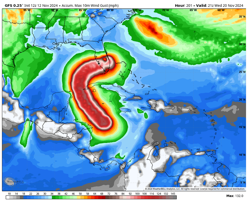
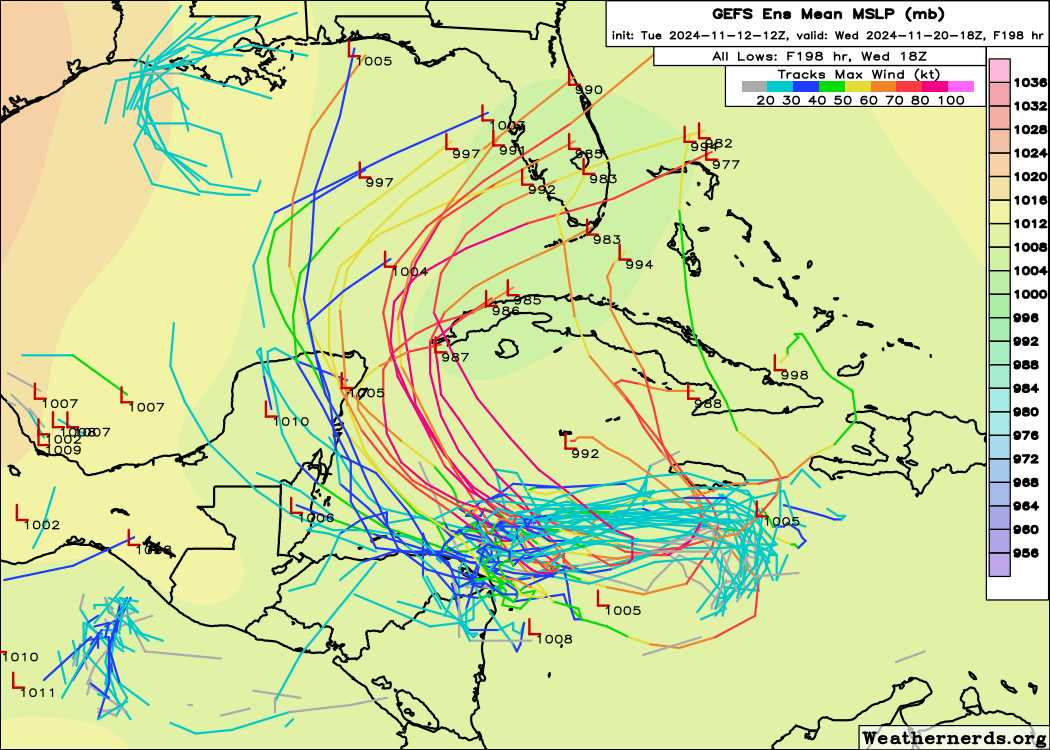
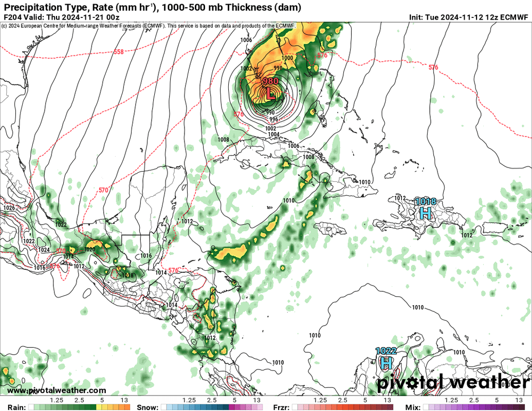
Disorganized showers and thunderstorms over the central Caribbean
Sea are associated with a broad area of low pressure.
Environmental conditions appear conducive for development, and a
tropical depression is likely to form within the next two to three
days while the system moves slowly westward into the western
Caribbean Sea. Afterward, further development is likely while the
disturbance meanders over the western Caribbean Sea through the
weekend. The system is forecast begin moving slowly northwestward
by early next week. Interests across the western and northwestern
Caribbean Sea should monitor the progress of this system.
* Formation chance through 48 hours...medium...60 percent.
* Formation chance through 7 days...high...90 percent.

$$
Forecaster Brown
3 likes   
Visit the Caribbean-Central America Weather Thread where you can find at first post web cams,radars
and observations from Caribbean basin members Click Here

User avatar
chaser1
S2K Supporter
S2K Supporter
Posts: 5463
Age: 64
Joined: Sat Oct 15, 2005 5:59 pm
Location: Longwood, Fl

Re: Potential development over the Western Caribbean Sea (40/80)

#165 Postby chaser1 » Tue Nov 12, 2024 12:34 pm


Great view! Resolution aside, looking at both your link and visible satellite from Tidbits, I'm starting to think that T.T. may be not updating as quickly?
0 likes   
Andy D

(For official information, please refer to the NHC and NWS products.)

zzzh
Category 3
Category 3
Posts: 834
Joined: Thu Sep 02, 2021 1:13 pm

Re: Potential development over the Western Caribbean Sea (60/90)

#166 Postby zzzh » Tue Nov 12, 2024 12:48 pm

12z Euro has it moving very close to the Nicaragua coast. Models are trending that way except the GFS.
0 likes   

ineedsnow
Tropical Low
Tropical Low
Posts: 18
Joined: Wed Aug 31, 2022 7:41 pm

Re: Potential development over the Western Caribbean Sea (60/90)

#167 Postby ineedsnow » Tue Nov 12, 2024 12:52 pm

zzzh wrote:12z Euro has it moving very close to the Nicaragua coast. Models are trending that way except the GFS.


makes landfall in south Florida at 988mb
0 likes   

User avatar
SFLcane
S2K Supporter
S2K Supporter
Posts: 10163
Age: 47
Joined: Sat Jun 05, 2010 1:44 pm
Location: Lake Worth Florida

Re: Potential development over the Western Caribbean Sea (60/90)

#168 Postby SFLcane » Tue Nov 12, 2024 12:55 pm

Image
0 likes   

User avatar
chaser1
S2K Supporter
S2K Supporter
Posts: 5463
Age: 64
Joined: Sat Oct 15, 2005 5:59 pm
Location: Longwood, Fl

Re: Potential development over the Western Caribbean Sea (60/90)

#169 Postby chaser1 » Tue Nov 12, 2024 12:58 pm

zzzh wrote:12z Euro has it moving very close to the Nicaragua coast. Models are trending that way except the GFS.


Nice, I'd take that solution! Please share link? All I can see on the EC Fast is the 24 hr forecast on Tropical Tidbits. It's 12Z doesn't go out nearly far enough to depict the disturbance nearing C. America, and the AIFS is rather pointless given its very low resolution
0 likes   
Andy D

(For official information, please refer to the NHC and NWS products.)

User avatar
SFLcane
S2K Supporter
S2K Supporter
Posts: 10163
Age: 47
Joined: Sat Jun 05, 2010 1:44 pm
Location: Lake Worth Florida

Re: Potential development over the Western Caribbean Sea (60/90)

#170 Postby SFLcane » Tue Nov 12, 2024 1:00 pm

Image
1 likes   

User avatar
GCANE
S2K Supporter
S2K Supporter
Posts: 11487
Joined: Mon Oct 22, 2007 8:03 am

Re: Potential development over the Western Caribbean Sea (60/90)

#171 Postby GCANE » Tue Nov 12, 2024 1:02 pm

Development in the W Carib is just about as ideal as you can get.
Massive anti-cyclone overhead with tons of EPAC high TPW air streaming in.
Not to mention over the highest OHC water in the Atlantic and a relatively cold upper troposphere.
Wouldn't be surprised this may break Wilma's record or at least get very close.
I think a lot of people will be freaking out in the days ahead when they see this possibly heading to FL.
2 likes   

ChrisH-UK
Category 2
Category 2
Posts: 623
Joined: Sat May 29, 2021 8:22 am

Re: Potential development over the Western Caribbean Sea (60/90)

#172 Postby ChrisH-UK » Tue Nov 12, 2024 1:03 pm

Looking at the models this doesn't exist and it's not in the area that it's supposed to start in, probably a case of it been too small and not getting seen.. Going to be interesting to see how the models pan out

Image
Last edited by ChrisH-UK on Tue Nov 12, 2024 1:05 pm, edited 1 time in total.
5 likes   

User avatar
SFLcane
S2K Supporter
S2K Supporter
Posts: 10163
Age: 47
Joined: Sat Jun 05, 2010 1:44 pm
Location: Lake Worth Florida

Re: Potential development over the Western Caribbean Sea (60/90)

#173 Postby SFLcane » Tue Nov 12, 2024 1:04 pm

Euro hits sfl as pontentially a cat 2...

Image
1 likes   

AxaltaRacing24
Category 5
Category 5
Posts: 1753
Age: 25
Joined: Wed Jul 27, 2016 11:14 am
Location: Jupiter, FL

Re: Potential development over the Western Caribbean Sea (60/90)

#174 Postby AxaltaRacing24 » Tue Nov 12, 2024 1:07 pm

SFLcane wrote:Euro hits sfl as pontentially a cat 2...

https://i.postimg.cc/kX9hLyM9/BBBB.png

At least this is 8 days out, still room for error (we hope).
2 likes   

User avatar
Travorum
Category 1
Category 1
Posts: 406
Joined: Tue Sep 05, 2023 9:36 am
Location: Dunedin, FL

Re: Potential development over the Western Caribbean Sea (60/90)

#175 Postby Travorum » Tue Nov 12, 2024 1:08 pm


Looking at these ensembles it seems like the only big question left wrt future intensity is land interaction. Almost every ensemble member that avoids Central America develops into at least a hurricane, and almost every ensemble member that interacts with land is put on a trajectory that struggles to produce even a tropical storm (EDIT: looking at a gif of the ensemble tracks this may be the inverse relationship, where a faster developing system doesn't go as far west. I can't quite tell). That makes sense when the OHC in the WCar looks like this:

Image
Last edited by Travorum on Tue Nov 12, 2024 1:15 pm, edited 1 time in total.
0 likes   

User avatar
cycloneye
Admin
Admin
Posts: 145250
Age: 68
Joined: Thu Oct 10, 2002 10:54 am
Location: San Juan, Puerto Rico

Re: Potential development over the Western Caribbean Sea (60/90)

#176 Postby cycloneye » Tue Nov 12, 2024 1:12 pm

Recon starting tommorow.

ATLANTIC REQUIREMENTS
1. SUSPECT AREA (WESTERN CARIBBEAN)
FLIGHT ONE - TEAL 71 FLIGHT TWO - TEAL 72
A. 13/1900Z A. 14/1130Z
B. AFXXX 01JJA INVEST B. AFXXX 0219A CYCLONE
C. 13/1500Z C. 14/0800Z
D. 16.5N 77.5W D. 16.8N 80.8W
E. 13/1830Z TO 13/2200Z E. 14/1100Z TO 14/1430Z
F. SFC TO 10,000 FT F. SFC TO 10,000 FT
G. LOW-LEVEL INVEST G. FIX
H. NO WRA ACTIVATION H. NO WRA ACTIVATION

2. OUTLOOK FOR SUCCEEDING DAY:
A. CONTINUE 6-HRLY FIXES IF SYSTEM DEVELOPS AND IS A THREAT.
B. POSSIBLE NOAA 42 P-3 TAIL DOPPLER RADAR MISSION INTO THE
SUSPECT AREA FOR 15/1200Z, DEPARTING KLAL AT 15/0800Z.
C. POSSIBLE NOAA 49 G-IV SYNOPTIC SURVEILLANCE MISSION AROUND
THE SUSPECT AREA FOR 15/1200Z, DEPARTING KLAL AT 15/0530Z.
2 likes   
Visit the Caribbean-Central America Weather Thread where you can find at first post web cams,radars
and observations from Caribbean basin members Click Here

ineedsnow
Tropical Low
Tropical Low
Posts: 18
Joined: Wed Aug 31, 2022 7:41 pm

Re: Potential development over the Western Caribbean Sea (60/90)

#177 Postby ineedsnow » Tue Nov 12, 2024 1:12 pm

12z EPS is ugly for Florida
0 likes   

xironman
S2K Supporter
S2K Supporter
Posts: 2522
Joined: Sun Jun 10, 2007 4:53 pm
Location: NoVA

Re: Potential development over the Western Caribbean Sea (60/90)

#178 Postby xironman » Tue Nov 12, 2024 1:12 pm

ChrisH-UK wrote:Looking at the models this doesn't exist and it's not in the area that it's supposed to start in, probably a case of it been too small and not getting seen.. Going to be interesting to see how the models pan out

[url]https://imagizer.imageshack.com/img923/6939/6j1QzE.gif [/url]


Its a swirl in the middle of a desert.

Image
1 likes   

User avatar
aspen
Category 5
Category 5
Posts: 8818
Joined: Sat Oct 12, 2019 7:10 pm
Location: Connecticut, USA

Re: Potential development over the Western Caribbean Sea (60/90)

#179 Postby aspen » Tue Nov 12, 2024 1:13 pm

zzzh wrote:12z Euro has it moving very close to the Nicaragua coast. Models are trending that way except the GFS.

Now I’m convinced how far west future 99L/Sara gets on the models is tied to its intensity. GFS is stronger in the short term and doesn’t get as far west as the weaker Euro/CMC/ICON. Probably model bias on display here. If we see something develop in 24-48 hours then the GFS is probably right.
3 likes   
Irene '11 Sandy '12 Hermine '16 5/15/2018 Derecho Fay '20 Isaias '20 Elsa '21 Henri '21 Ida '21

I am only a meteorology enthusiast who knows a decent amount about tropical cyclones. Look to the professional mets, the NHC, or your local weather office for the best information.

jlauderdal
S2K Supporter
S2K Supporter
Posts: 7182
Joined: Wed May 19, 2004 5:46 am
Location: NE Fort Lauderdale
Contact:

Re: Potential development over the Western Caribbean Sea (60/90)

#180 Postby jlauderdal » Tue Nov 12, 2024 1:16 pm

GCANE wrote:Development in the W Carib is just about as ideal as you can get.
Massive anti-cyclone overhead with tons of EPAC high TPW air streaming in.
Not to mention over the highest OHC water in the Atlantic and a relatively cold upper troposphere.
Wouldn't be surprised this may break Wilma's record or at least get very close.
I think a lot of people will be freaking out in the days ahead when they see this possibly heading to FL.

Amazing to see how favorable it is for the next week until the trough comes in, its mid-november.
1 likes   


Return to “Talkin' Tropics”

Who is online

Users browsing this forum: Hurrilurker and 31 guests