2023 Indicators (SST, SAL, MSLP, Wind shear, Steering, Instability) and Day 16+ Models

This is the general tropical discussion area. Anyone can take their shot at predicting a storms path.

Moderator: S2k Moderators

Forum rules

The posts in this forum are NOT official forecasts and should not be used as such. They are just the opinion of the poster and may or may not be backed by sound meteorological data. They are NOT endorsed by any professional institution or STORM2K. For official information, please refer to products from the National Hurricane Center and National Weather Service.

Help Support Storm2K
Message
Author
User avatar
NDG
S2K Supporter
S2K Supporter
Posts: 15446
Joined: Sun Jul 09, 2006 10:14 pm
Location: Orlando, FL

Re: 2023 Indicators (SST, SAL, MSLP, Wind shear, Steering, Instability) and Day 16+ Models

#1521 Postby NDG » Mon Sep 11, 2023 3:27 pm

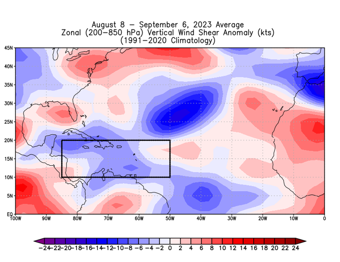
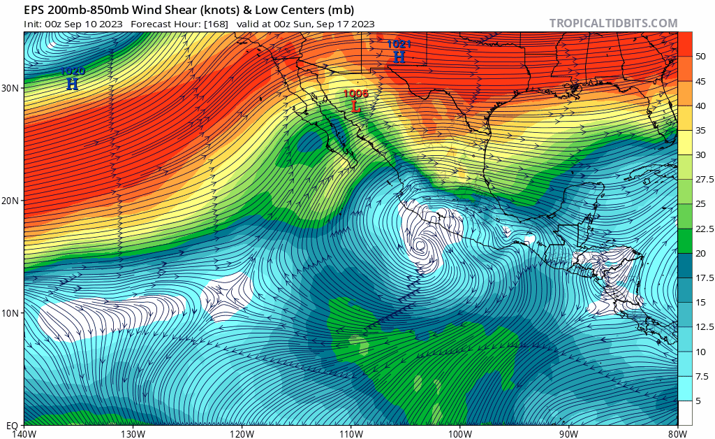
gatorcane wrote:The GEFS and EPS are showing an active sub-tropical jet originating from the EPAC which positions itself right over the GOM and Florida in the wake of Lee and sits there there through rest of the model runs through 384 hours. That looks more like an El Niño look to me and probably why the ensembles are not showing much there. It is certainly possible the GOM and possibly Caribbean shut down early this year because of the El Niño and some of the long-range modeling is hinting at that:

https://i.postimg.cc/zvVzV3fn/eps-shear-epac-fh168-282.gif


The Caribbean still looks favorable through the next 15 days.

Image
1 likes   

User avatar
NDG
S2K Supporter
S2K Supporter
Posts: 15446
Joined: Sun Jul 09, 2006 10:14 pm
Location: Orlando, FL

Re: 2023 Indicators (SST, SAL, MSLP, Wind shear, Steering, Instability) and Day 16+ Models

#1522 Postby NDG » Mon Sep 11, 2023 4:15 pm

Crazy that this season has produced more Major Hurricane days than in 2022, a La Nina year. Definitely the ENSO is not the biggest factor in the equation over the Atlantic Basin.

 https://twitter.com/philklotzbach/status/1701341913989923192


2 likes   

User avatar
cycloneye
Admin
Admin
Posts: 145292
Age: 68
Joined: Thu Oct 10, 2002 10:54 am
Location: San Juan, Puerto Rico

Re: 2023 Indicators (SST, SAL, MSLP, Wind shear, Steering, Instability) and Day 16+ Models

#1523 Postby cycloneye » Mon Sep 11, 2023 5:00 pm

1 likes   
Visit the Caribbean-Central America Weather Thread where you can find at first post web cams,radars
and observations from Caribbean basin members Click Here

User avatar
Steve
S2K Supporter
S2K Supporter
Posts: 9620
Joined: Sat Apr 05, 2003 11:41 pm
Location: Not a state-caster

Re: 2023 Indicators (SST, SAL, MSLP, Wind shear, Steering, Instability) and Day 16+ Models

#1524 Postby Steve » Mon Sep 11, 2023 6:09 pm

NDG wrote:This is probably as close as Andy Hazelton will come in saying "I stand corrected" :wink:
I even remember him saying that he would quit Meteorology if the strong El Nino didn't shut down the Atlantic during the peak of the season.

https://twitter.com/AndyHazelton/status/1701284520656318471


He wasn’t one of them.
0 likes   

User avatar
Hurricane2022
Category 5
Category 5
Posts: 1541
Joined: Tue Aug 23, 2022 11:38 pm
Location: Araçatuba, Brazil

Re: 2023 Indicators (SST, SAL, MSLP, Wind shear, Steering, Instability) and Day 16+ Models

#1525 Postby Hurricane2022 » Mon Sep 11, 2023 6:17 pm

Yo soy LOL Niño!!! :roflmao:
Image
6 likes   
Sorry for the bad English sometimes...!
For reliable and detailed information for any meteorological phenomenon, please consult the National Hurricane Center, Joint Typhoon Warning Center , or your local Meteo Center.

--------

Una cvm Christo, pro Christo, et in Christo. Sit nomen Domini benedictvm.

User avatar
Category5Kaiju
Category 5
Category 5
Posts: 4095
Joined: Thu Dec 24, 2020 12:45 pm
Location: Seattle

Re: 2023 Indicators (SST, SAL, MSLP, Wind shear, Steering, Instability) and Day 16+ Models

#1526 Postby Category5Kaiju » Mon Sep 11, 2023 6:42 pm

Hurricane2022 wrote:Yo soy LOL Niño!!! :roflmao:
https://imageshack.com/i/pm5xYv7pg


Some individuals on wx social media were insisting that Franklin and Idalia were just flukes and that things would dramatically become quiet by this month.

Um...
2 likes   
Unless explicitly stated, all info in my posts is based on my own opinions and observations. Tropical storms and hurricanes can be extremely dangerous. Do not think you can beat Mother Nature. Refer to an accredited weather research agency or meteorologist if you need to make serious decisions regarding an approaching storm.


User avatar
CyclonicFury
Category 5
Category 5
Posts: 2025
Age: 26
Joined: Sun Jul 02, 2017 12:32 pm
Location: NC
Contact:

Re: 2023 Indicators (SST, SAL, MSLP, Wind shear, Steering, Instability) and Day 16+ Models

#1528 Postby CyclonicFury » Mon Sep 11, 2023 10:49 pm

Moderate-strong El Ninos in the satellite era:

1968: 8-5-0, 45 ACE
1972: 7-3-0, 36 ACE
1982: 6-2-1, 32 ACE
1986: 6-4-0, 36 ACE
1987: 7-3-1, 34 ACE
1991: 8-4-2, 36 ACE
1994: 7-3-0, 32 ACE
1997: 7-3-1, 41 ACE
2002: 12-4-2, 68 ACE
2009: 9-3-2, 55 ACE
2015: 11-4-2, 62 ACE
2023: 14-5-3, 84 ACE (through September 11th)

What we're seeing so far this season is truly unprecedented, as 2023 has already produced more named storms, major hurricanes and ACE than any moderate/strong El Nino FULL SEASON in the satellite era, and is tied with 1968 for the most hurricanes. And there's still 80 days of hurricane season to go. The closest precedent we have is the pre-satellite era season of 1951, which produced 12 named storms, 8 hurricanes, 3 major hurricanes with an ACE of ~126.
18 likes   
NCSU B.S. in Meteorology Class of 2021. Tropical weather blogger at http://www.cyclonicfury.com. My forecasts and thoughts are NOT official, for official forecasts please consult the National Hurricane Center.

Ianswfl
Category 1
Category 1
Posts: 482
Joined: Thu Mar 23, 2023 11:11 pm

Re: 2023 Indicators (SST, SAL, MSLP, Wind shear, Steering, Instability) and Day 16+ Models

#1529 Postby Ianswfl » Mon Sep 11, 2023 11:19 pm

Looking way way ahead, if the long range climate models are right like the CFS regarding the SST next spring and summer, well if the El Nino fades expect things to really be rocking next season, especially in the Gulf and Carribean. Very similar set up to this summer's sst and if we are in neutral or La Nina :eek: :eek:

https://www.tropicaltidbits.com/analysi ... 91106&fh=1
2 likes   

ChrisH-UK
Category 2
Category 2
Posts: 625
Joined: Sat May 29, 2021 8:22 am

Re: 2023 Indicators (SST, SAL, MSLP, Wind shear, Steering, Instability) and Day 16+ Models

#1530 Postby ChrisH-UK » Tue Sep 12, 2023 5:26 am

Ok with this year I have been a big proponent of this year been a 'Hot Neutral' year in regards of El Nino/La Nina.

I have been looking for research and papers on whether the heat differences between the 2 oceans rather than the winds and pressure play a part in the effects that happen with the El-Nino/La Nina cycle. I haven't been able to find any information in regards to this and I want to look at this further myself. I can easily get historical temperature data for the El Nino regions but finding historical temperature data the Atlantic MDR is proving much harder to get. Getting anomalies is easy but actual temps seems to much harder to get after looking for them the last couple of months.

So any ideas where I can get say monthly averages sea surface temperatures of the Atlantic MDR.
2 likes   

User avatar
NDG
S2K Supporter
S2K Supporter
Posts: 15446
Joined: Sun Jul 09, 2006 10:14 pm
Location: Orlando, FL

Re: 2023 Indicators (SST, SAL, MSLP, Wind shear, Steering, Instability) and Day 16+ Models

#1531 Postby NDG » Tue Sep 12, 2023 8:14 am

Ianswfl wrote:Looking way way ahead, if the long range climate models are right like the CFS regarding the SST next spring and summer, well if the El Nino fades expect things to really be rocking next season, especially in the Gulf and Carribean. Very similar set up to this summer's sst and if we are in neutral or La Nina :eek: :eek:

https://www.tropicaltidbits.com/analysi ... 91106&fh=1


I hate to speculate this far out that next year could be a block buster. There are so many factors that play a role like the constant wave breakings we saw last year, strength of the Azores High, SAL outbreaks, African monsoon, heat waves in the mid latitudes, etc.
1 likes   

jconsor
Professional-Met
Professional-Met
Posts: 551
Joined: Mon Jun 30, 2008 9:31 pm
Location: Jerusalem, Israel
Contact:

Re: 2023 Indicators (SST, SAL, MSLP, Wind shear, Steering, Instability) and Day 16+ Models

#1532 Postby jconsor » Tue Sep 12, 2023 8:34 am

You can create your own time series by defining the lat/lon of the MDR.

https://psl.noaa.gov/data/oceanwrit/timeseries/ (I recommend selecting ERSST under "Dataset) as it has the longest dataset (1856 to present)

You can also use this site (https://climatereanalyzer.org/research_ ... y_tseries/) for a similar purpose.

ChrisH-UK wrote:Ok with this year I have been a big proponent of this year been a 'Hot Neutral' year in regards of El Nino/La Nina.

I have been looking for research and papers on whether the heat differences between the 2 oceans rather than the winds and pressure play a part in the effects that happen with the El-Nino/La Nina cycle. I haven't been able to find any information in regards to this and I want to look at this further myself. I can easily get historical temperature data for the El Nino regions but finding historical temperature data the Atlantic MDR is proving much harder to get. Getting anomalies is easy but actual temps seems to much harder to get after looking for them the last couple of months.

So any ideas where I can get say monthly averages sea surface temperatures of the Atlantic MDR.
2 likes   

User avatar
SFLcane
S2K Supporter
S2K Supporter
Posts: 10163
Age: 47
Joined: Sat Jun 05, 2010 1:44 pm
Location: Lake Worth Florida

Re: 2023 Indicators (SST, SAL, MSLP, Wind shear, Steering, Instability) and Day 16+ Models

#1533 Postby SFLcane » Tue Sep 12, 2023 8:35 am

NDG wrote:
Ianswfl wrote:Looking way way ahead, if the long range climate models are right like the CFS regarding the SST next spring and summer, well if the El Nino fades expect things to really be rocking next season, especially in the Gulf and Carribean. Very similar set up to this summer's sst and if we are in neutral or La Nina :eek: :eek:

https://www.tropicaltidbits.com/analysi ... 91106&fh=1


I hate to speculate this far out that next year could be a block buster. There are so many factors that play a role like the constant wave breakings we saw last year, strength of the Azores High, SAL outbreaks, African monsoon, heat waves in the mid latitudes, etc.


That's the question is a blockbuster year for the fish or the Conus? We shall see
0 likes   

jconsor
Professional-Met
Professional-Met
Posts: 551
Joined: Mon Jun 30, 2008 9:31 pm
Location: Jerusalem, Israel
Contact:

Re: 2023 Indicators (SST, SAL, MSLP, Wind shear, Steering, Instability) and Day 16+ Models

#1534 Postby jconsor » Tue Sep 12, 2023 8:36 am

I think we need to watch the eastern Caribbean in late Sep. Also expecting more NW Caribbean activity than usual in Oct-Nov for an El Nino.

 https://twitter.com/yconsor/status/1701549729803297243


 https://twitter.com/yconsor/status/1701577706637242411


 https://twitter.com/yconsor/status/1701583064885874875


9 likes   

User avatar
SFLcane
S2K Supporter
S2K Supporter
Posts: 10163
Age: 47
Joined: Sat Jun 05, 2010 1:44 pm
Location: Lake Worth Florida

Re: 2023 Indicators (SST, SAL, MSLP, Wind shear, Steering, Instability) and Day 16+ Models

#1535 Postby SFLcane » Tue Sep 12, 2023 10:10 am

jconsor wrote:I think we need to watch the eastern Caribbean in late Sep. Also expecting more NW Caribbean activity than usual in Oct-Nov for an El Nino.

https://twitter.com/yconsor/status/1701549729803297243

https://twitter.com/yconsor/status/1701577706637242411

https://twitter.com/yconsor/status/1701583064885874875


I'm not seeing a disturbance to take advantage yet but its almost CAG time.

Image
1 likes   

User avatar
CyclonicFury
Category 5
Category 5
Posts: 2025
Age: 26
Joined: Sun Jul 02, 2017 12:32 pm
Location: NC
Contact:

Re: 2023 Indicators (SST, SAL, MSLP, Wind shear, Steering, Instability) and Day 16+ Models

#1536 Postby CyclonicFury » Tue Sep 12, 2023 11:59 am

The velocity potential anomaly pattern has continued to look a bit different from your standard Nino look, with the Pacific rising cell displaced west and anomalous sinking over the EPAC.

Image
1 likes   
NCSU B.S. in Meteorology Class of 2021. Tropical weather blogger at http://www.cyclonicfury.com. My forecasts and thoughts are NOT official, for official forecasts please consult the National Hurricane Center.

User avatar
WalterWhite
Category 1
Category 1
Posts: 342
Joined: Fri Mar 17, 2023 5:53 pm

Re: 2023 Indicators (SST, SAL, MSLP, Wind shear, Steering, Instability) and Day 16+ Models

#1537 Postby WalterWhite » Tue Sep 12, 2023 1:39 pm

CyclonicFury wrote:The velocity potential anomaly pattern has continued to look a bit different from your standard Nino look, with the Pacific rising cell displaced west and anomalous sinking over the EPAC.

https://i.imgur.com/Fo8ZDqw.gif


That is not exactly the most favorable VP pattern for the North Atlantic, though. That clearly shows sinking air over Africa and the Indian Ocean.
0 likes   

Chris90
Category 2
Category 2
Posts: 646
Age: 35
Joined: Thu Jun 01, 2017 9:36 pm

Re: 2023 Indicators (SST, SAL, MSLP, Wind shear, Steering, Instability) and Day 16+ Models

#1538 Postby Chris90 » Tue Sep 12, 2023 2:16 pm

WalterWhite wrote:
CyclonicFury wrote:The velocity potential anomaly pattern has continued to look a bit different from your standard Nino look, with the Pacific rising cell displaced west and anomalous sinking over the EPAC.

https://i.imgur.com/Fo8ZDqw.gif


That is not exactly the most favorable VP pattern for the North Atlantic, though. That clearly shows sinking air over Africa and the Indian Ocean.


That's a composite from the last 3 months, not a forecast.
Come November, if you do a composite from August-Nov, it'll look different. This composite is a good explanation for one of the major reasons why the EPAC wasn't quite as active back in June and July despite a strengthening Niño.
0 likes   
Solar Aquarian
Lunar Cancerian
:uarrow: Sagittarian

User avatar
SFLcane
S2K Supporter
S2K Supporter
Posts: 10163
Age: 47
Joined: Sat Jun 05, 2010 1:44 pm
Location: Lake Worth Florida

Re: 2023 Indicators (SST, SAL, MSLP, Wind shear, Steering, Instability) and Day 16+ Models

#1539 Postby SFLcane » Tue Sep 12, 2023 2:25 pm

This pattern currently in place concerns me in October in the caribbean in particualr for the the florida peninsula even though there's a subtropical jet across the Gulf.
1 likes   

USTropics
Professional-Met
Professional-Met
Posts: 2650
Joined: Sun Aug 12, 2007 3:45 am
Location: Florida State University

Re: 2023 Indicators (SST, SAL, MSLP, Wind shear, Steering, Instability) and Day 16+ Models

#1540 Postby USTropics » Tue Sep 12, 2023 2:29 pm

WalterWhite wrote:
CyclonicFury wrote:The velocity potential anomaly pattern has continued to look a bit different from your standard Nino look, with the Pacific rising cell displaced west and anomalous sinking over the EPAC.

https://i.imgur.com/Fo8ZDqw.gif


That is not exactly the most favorable VP pattern for the North Atlantic, though. That clearly shows sinking air over Africa and the Indian Ocean.


Definitely not an El Nino look, nor a hyperactive (160+ ACE season) look either. A seasonal (or trimonthly in this case) observation doesn't exactly show the finer details though, as it gets averaged out over such a long period of time. For instance, take a snapshot of the last 2 weeks, and we have a VP+ configuration that would suggest a hyperactive period (which we've had over the past 2 weeks):
Image
3 likes   


Return to “Talkin' Tropics”

Who is online

Users browsing this forum: Ulf, USTropics and 39 guests