

Bay of Bengal: VSCS Mala - Possible catastrophe for Myanmar
Moderator: S2k Moderators
Forum rules

The posts in this forum are NOT official forecasts and should not be used as such. They are just the opinion of the poster and may or may not be backed by sound meteorological data. They are NOT endorsed by any professional institution or STORM2K. For official information, please refer to products from the National Hurricane Center and National Weather Service.
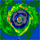
This pass was from about five hours ago. Mala has a very tight core. Once the system gets caught up in the southwesterly flow and the core gains forward speed, the mild upperlevel shear that it has been experiencing may enhance the ventilation and assist in intensification.
Last edited by Windspeed on Thu Apr 27, 2006 5:09 pm, edited 1 time in total.
0 likes

-
x-y-no

- Category 5

- Posts: 8359
- Age: 65
- Joined: Wed Aug 11, 2004 12:14 pm
- Location: Fort Lauderdale, FL
I don't know a lot about Myanmar, but I'd have to think that river delta region just east of the forecast track would be very low-lying and heavily populated. And I do know the government is a military dictatorship which isn't particularly well know for its concern for the people.
Those don't add up to a very good situation as regards preparation for an event like may be.
Those don't add up to a very good situation as regards preparation for an event like may be.
0 likes
-
HURAKAN

- Professional-Met

- Posts: 46086
- Age: 38
- Joined: Thu May 20, 2004 4:34 pm
- Location: Key West, FL
- Contact:
323
FKIN20 VIDP 271530
TC ADVISOTRY
-----------
DTG : 20060427/1200Z
TCAC : NEW DELHI
TC : MALA
NR : 09
PSN : N1330 E09030
MOV : N 03KT
C : 984HPA
MAX WIND : 65KT
FCST PSN + 12HRS : 280000 N1330 E09100
MAX WIND + 12HRS : 70 KT
FCST PSN + 18HRS : 280600 N1400 E09100
MAX WIND + 18HRS : 75KT
FCST PSN + 24HRS : 281200 N1430 E09130
MAX WIND + 24HRS : 75 KT
NEXT MSG : 20060427/1800 Z
0 likes

-
HURAKAN
- Professional-Met
- Posts: 46086
- Age: 38
- Joined: Thu May 20, 2004 4:34 pm
- Location: Key West, FL
- Contact:

WTIO31 PGTW 272100
MSGID/GENADMIN/NAVPACMETOCCEN PEARL HARBOR HI/JTWC//
SUBJ/TROPICAL CYCLONE WARNING//
RMKS/
IMMEDIATE DELIVERY REQ TO AMCONSUL CALCUTTA AND AMEMBASSY DHAKA
1. TROPICAL CYCLONE 02B (MALA) WARNING NR 008
01 ACTIVE TROPICAL CYCLONE IN NORTHIO
MAX SUSTAINED WINDS BASED ON ONE-MINUTE AVERAGE
---
WARNING POSITION:
271800Z --- NEAR 13.3N 90.8E
MOVEMENT PAST SIX HOURS - 050 DEGREES AT 06 KTS
POSITION ACCURATE TO WITHIN 040 NM
POSITION BASED ON CENTER LOCATED BY SATELLITE
PRESENT WIND DISTRIBUTION:
MAX SUSTAINED WINDS - 080 KT, GUSTS 100 KT
RADIUS OF 064 KT WINDS - 025 NM NORTHEAST QUADRANT
025 NM SOUTHEAST QUADRANT
025 NM SOUTHWEST QUADRANT
025 NM NORTHWEST QUADRANT
RADIUS OF 050 KT WINDS - 040 NM NORTHEAST QUADRANT
040 NM SOUTHEAST QUADRANT
040 NM SOUTHWEST QUADRANT
040 NM NORTHWEST QUADRANT
RADIUS OF 034 KT WINDS - 100 NM NORTHEAST QUADRANT
100 NM SOUTHEAST QUADRANT
090 NM SOUTHWEST QUADRANT
090 NM NORTHWEST QUADRANT
REPEAT POSIT: 13.3N 90.8E
---
FORECASTS:
12 HRS, VALID AT:
280600Z --- 14.1N 91.5E
MAX SUSTAINED WINDS - 080 KT, GUSTS 100 KT
RADIUS OF 064 KT WINDS - 025 NM NORTHEAST QUADRANT
025 NM SOUTHEAST QUADRANT
025 NM SOUTHWEST QUADRANT
025 NM NORTHWEST QUADRANT
RADIUS OF 050 KT WINDS - 045 NM NORTHEAST QUADRANT
045 NM SOUTHEAST QUADRANT
045 NM SOUTHWEST QUADRANT
045 NM NORTHWEST QUADRANT
RADIUS OF 034 KT WINDS - 110 NM NORTHEAST QUADRANT
120 NM SOUTHEAST QUADRANT
100 NM SOUTHWEST QUADRANT
100 NM NORTHWEST QUADRANT
VECTOR TO 24 HR POSIT: 040 DEG/ 05 KTS
---
24 HRS, VALID AT:
281800Z --- 14.8N 92.1E
MAX SUSTAINED WINDS - 085 KT, GUSTS 105 KT
RADIUS OF 064 KT WINDS - 030 NM NORTHEAST QUADRANT
030 NM SOUTHEAST QUADRANT
030 NM SOUTHWEST QUADRANT
030 NM NORTHWEST QUADRANT
RADIUS OF 050 KT WINDS - 050 NM NORTHEAST QUADRANT
050 NM SOUTHEAST QUADRANT
050 NM SOUTHWEST QUADRANT
050 NM NORTHWEST QUADRANT
RADIUS OF 034 KT WINDS - 120 NM NORTHEAST QUADRANT
130 NM SOUTHEAST QUADRANT
115 NM SOUTHWEST QUADRANT
110 NM NORTHWEST QUADRANT
VECTOR TO 36 HR POSIT: 035 DEG/ 07 KTS
---
36 HRS, VALID AT:
290600Z --- 16.0N 92.9E
MAX SUSTAINED WINDS - 090 KT, GUSTS 110 KT
RADIUS OF 064 KT WINDS - 030 NM NORTHEAST QUADRANT
030 NM SOUTHEAST QUADRANT
030 NM SOUTHWEST QUADRANT
030 NM NORTHWEST QUADRANT
RADIUS OF 050 KT WINDS - 060 NM NORTHEAST QUADRANT
065 NM SOUTHEAST QUADRANT
060 NM SOUTHWEST QUADRANT
060 NM NORTHWEST QUADRANT
RADIUS OF 034 KT WINDS - 110 NM NORTHEAST QUADRANT
115 NM SOUTHEAST QUADRANT
125 NM SOUTHWEST QUADRANT
120 NM NORTHWEST QUADRANT
VECTOR TO 48 HR POSIT: 030 DEG/ 09 KTS
---
EXTENDED OUTLOOK:
48 HRS, VALID AT:
291800Z --- 17.6N 93.8E
MAX SUSTAINED WINDS - 090 KT, GUSTS 110 KT
RADIUS OF 064 KT WINDS - 030 NM NORTHEAST QUADRANT
030 NM SOUTHEAST QUADRANT
030 NM SOUTHWEST QUADRANT
030 NM NORTHWEST QUADRANT
RADIUS OF 050 KT WINDS - 040 NM NORTHEAST QUADRANT
040 NM SOUTHEAST QUADRANT
050 NM SOUTHWEST QUADRANT
040 NM NORTHWEST QUADRANT
RADIUS OF 034 KT WINDS - 090 NM NORTHEAST QUADRANT
OVER WATER
080 NM SOUTHEAST QUADRANT
OVER WATER
100 NM SOUTHWEST QUADRANT
100 NM NORTHWEST QUADRANT
---
REMARKS:272100Z POSITION NEAR 13.5N 91.0E.
TROPICAL CYCLONE (TC) 02B (MALA), LOCATED APPROXIMATELY 375 NM WEST-
SOUTHWEST OF YANGON, MYANMAR, HAS TRACKED NORTHEASTWARD AT 06 KNOTS
OVER THE PAST 06 HOURS. RECENT ANIMATED ENHANCED WATER VAPOR IMAGERY
REVEALS POLEWARD OUTFLOW LINKAGE WITH THE MIDLATITUDE WESTERLIES.
TC 02B WILL CONTINUE TO SLOWLY TRACK POLEWARD ALONG THE WESTERN
PERIPHERY OF THE STEERING RIDGE ANCHORED OVER SOUTHEAST ASIA.
GRADUAL INTENSIFICATION WILL OCCUR AS TC 02B TRACKS NORTH AND THE
POLEWARD OUTFLOW CHANNEL INCREASES IN THE MIDLATITUDE WESTERLY FLOW.
MAXIMUM SIGNIFICANT WAVE HEIGHT AT 271800Z IS 27 FEET. NEXT WARNINGS
AT 280900Z AND 282100Z.

LOOKING REALY NICE!!!
0 likes


-
Scorpion
-
Epsilon_Fan

- Category 1

- Posts: 353
- Joined: Fri Jan 13, 2006 1:03 pm
- Location: Charleston, SC
-
MiamiensisWx
-
SouthFloridawx

- S2K Supporter

- Posts: 8346
- Age: 47
- Joined: Tue Jul 26, 2005 1:16 am
- Location: Sarasota, FL
- Contact:

-
SouthFloridawx
- S2K Supporter
- Posts: 8346
- Age: 47
- Joined: Tue Jul 26, 2005 1:16 am
- Location: Sarasota, FL
- Contact:
-
Tampa Bay Hurricane

- Category 5
- Posts: 5598
- Age: 38
- Joined: Fri Jul 22, 2005 7:54 pm
- Location: St. Petersburg, FL
-
Matt-hurricanewatcher
Update 5#/7pm pst/4-26-2006/Cyclone Mala
Tropical cyclone based on visible/Ir/85h data shows to have a very small pin hole eye. With Ir showing a very intense eyewall...Data out of sab holds it at 4.5=77 knots/Cimss 4.8=85 knots. 85h data shows a very intense eyewall which means it is likely 10 to 15 knots stronger then they are saying. A very deep cdo with good to impressive outflow has formed. In a eye is starting to form on the Ir/visible satellite. Winds are put at 90 knots for this forecast based on limited info. But would not be suprized if it was 100 to 105 knots at this time.
Shear appears to be around 8 knots over the core of the cyclone. Decreasing to the south...And staying the same to the north. Cyclone appears to be in a half way faverbale enviroment for strengthing. Forecasting a strengthing or maybe even a bombing over the next 24 hours. Basing on the clearing of the eye would not be surpized if this got to 120 knots.
Movement appears to be turning east-northeastward...In forecasting a esat-northeastward for the next 24 hours. Fellowed by a more northeastward after that....
Forecasted winds
0 90 knots
6 95 knots
12 105 knots
24 120 knots
36 115 knots
Forecaster Matthew
This forecast is unoffical...
0 likes


Who is online
Users browsing this forum: hurricanes1234, Zonacane and 107 guests