
Potential development over the Western Caribbean Sea (Is Invest 99L)
Moderator: S2k Moderators
Forum rules

The posts in this forum are NOT official forecasts and should not be used as such. They are just the opinion of the poster and may or may not be backed by sound meteorological data. They are NOT endorsed by any professional institution or STORM2K. For official information, please refer to products from the National Hurricane Center and National Weather Service.
-
chris_fit

- Category 5

- Posts: 3261
- Age: 43
- Joined: Wed Sep 10, 2003 11:58 pm
- Location: Tampa Bay Area, FL
Re: Potential development over the Western Caribbean Sea (40/80)
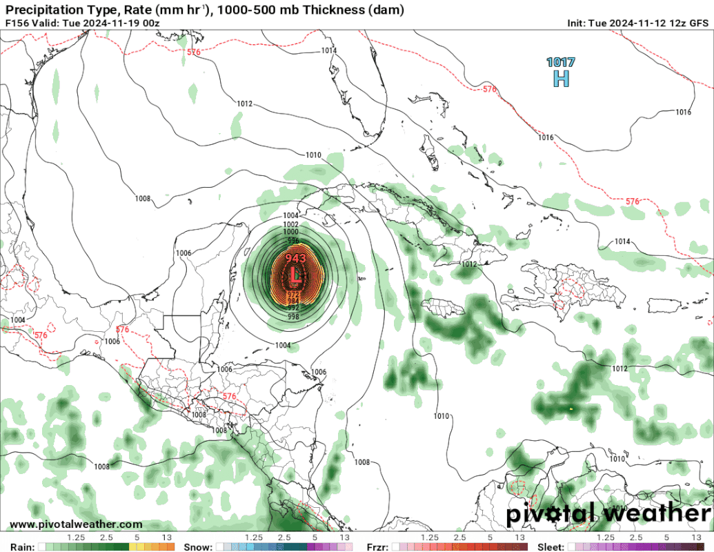
12Z GFS Nuclear again in the WC.
2 likes
-
SFLcane

- S2K Supporter

- Posts: 10281
- Age: 48
- Joined: Sat Jun 05, 2010 1:44 pm
- Location: Lake Worth Florida
Re: Potential development over the Western Caribbean Sea (40/80)
Incoming Cat 4 heading for the NW carib on the 12z GFS..
0 likes
-
SouthFLTropics

- Category 5
- Posts: 4258
- Age: 50
- Joined: Thu Aug 14, 2003 8:04 am
- Location: Port St. Lucie, Florida
Re: Potential development over the Western Caribbean Sea (40/80)
Looks like the west coast of FL is going to get blasted again on this GFS run. 
0 likes
Fourth Generation Florida Native
Personal Storm History: David 79, Andrew 92, Erin 95, Floyd 99, Irene 99, Frances 04, Jeanne 04, Wilma 05, Matthew 16, Irma 17, Ian 22, Nicole 22, Milton 24
Personal Storm History: David 79, Andrew 92, Erin 95, Floyd 99, Irene 99, Frances 04, Jeanne 04, Wilma 05, Matthew 16, Irma 17, Ian 22, Nicole 22, Milton 24
-
SFLcane
- S2K Supporter
- Posts: 10281
- Age: 48
- Joined: Sat Jun 05, 2010 1:44 pm
- Location: Lake Worth Florida
Re: Potential development over the Western Caribbean Sea (40/80)
SouthFLTropics wrote:Looks like the west coast of FL is going to get blasted again on this GFS run.
Wilma 2.0
0 likes
-
chris_fit
- Category 5
- Posts: 3261
- Age: 43
- Joined: Wed Sep 10, 2003 11:58 pm
- Location: Tampa Bay Area, FL
Re: Potential development over the Western Caribbean Sea (40/80)
946 MB

Last edited by chris_fit on Tue Nov 12, 2024 11:27 am, edited 1 time in total.
0 likes
-
DESTRUCTION5

- Category 5
- Posts: 4430
- Age: 44
- Joined: Wed Sep 03, 2003 11:25 am
- Location: Stuart, FL
Re: Potential development over the Western Caribbean Sea (40/80)
SFLcane wrote:SouthFLTropics wrote:Looks like the west coast of FL is going to get blasted again on this GFS run.
Wilma 2.0
Minus the stop in Cancun
0 likes
GATOR NATION IS E V E R Y W H E R E !

-
SouthFLTropics
- Category 5
- Posts: 4258
- Age: 50
- Joined: Thu Aug 14, 2003 8:04 am
- Location: Port St. Lucie, Florida
Re: Potential development over the Western Caribbean Sea (40/80)
Amazing but scary run to run consistency on the GFS at 8 days.
0 likes
Fourth Generation Florida Native
Personal Storm History: David 79, Andrew 92, Erin 95, Floyd 99, Irene 99, Frances 04, Jeanne 04, Wilma 05, Matthew 16, Irma 17, Ian 22, Nicole 22, Milton 24
Personal Storm History: David 79, Andrew 92, Erin 95, Floyd 99, Irene 99, Frances 04, Jeanne 04, Wilma 05, Matthew 16, Irma 17, Ian 22, Nicole 22, Milton 24
-
chris_fit
- Category 5
- Posts: 3261
- Age: 43
- Joined: Wed Sep 10, 2003 11:58 pm
- Location: Tampa Bay Area, FL
Re: Potential development over the Western Caribbean Sea (40/80)
FL Peninsula about to get slammed again according to 12z GFS

0 likes
-
SouthFLTropics
- Category 5
- Posts: 4258
- Age: 50
- Joined: Thu Aug 14, 2003 8:04 am
- Location: Port St. Lucie, Florida
Re: Potential development over the Western Caribbean Sea (40/80)
And at 200 hours the GFS rolls right over my house... I'm liking the ICON and the CMC solutions much better. GFS...you are not my friend!!! 
0 likes
Fourth Generation Florida Native
Personal Storm History: David 79, Andrew 92, Erin 95, Floyd 99, Irene 99, Frances 04, Jeanne 04, Wilma 05, Matthew 16, Irma 17, Ian 22, Nicole 22, Milton 24
Personal Storm History: David 79, Andrew 92, Erin 95, Floyd 99, Irene 99, Frances 04, Jeanne 04, Wilma 05, Matthew 16, Irma 17, Ian 22, Nicole 22, Milton 24

Re: Potential development over the Western Caribbean Sea (40/80)
Key difference between the GFS & ICON this a.m. being the speed by which each model deepens the disturbance. The 6Z GFS had reached sub <1000 mb at 66 hours, and the 12Z now continues to bring that time line closer now at 54 hrs. The biggest distinction however is the speed which GFS deepens this storm to sub 960 mb by around 96 hr's. My guess is that a more vertically stacked storm is less apt to be steered by the westward low level flow that ICON depicts the more shallow system to ultimately track. My thinking here leans more toward the near to mid term GFS solution simply given its better skill at forecasting intensity. All the more interesting it will be to see what the regional Hurricane models depict (once this becomes an invest this afternoon/evening).
1 likes
Andy D
(For official information, please refer to the NHC and NWS products.)
(For official information, please refer to the NHC and NWS products.)

-
SouthFLTropics
- Category 5
- Posts: 4258
- Age: 50
- Joined: Thu Aug 14, 2003 8:04 am
- Location: Port St. Lucie, Florida
Re: Potential development over the Western Caribbean Sea (40/80)
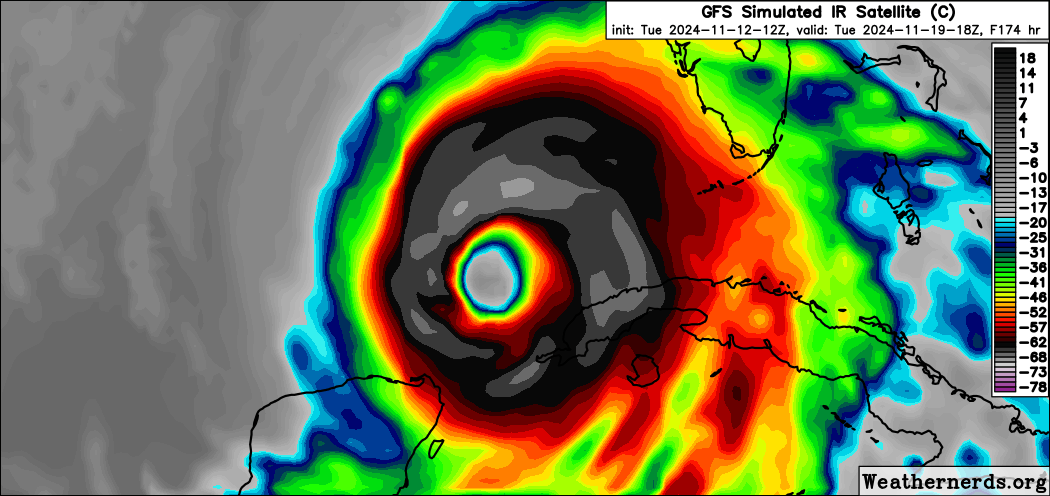
Man that GFS simulated satellite looks just like Wilma... All the way down to the large eye.
2 likes
Fourth Generation Florida Native
Personal Storm History: David 79, Andrew 92, Erin 95, Floyd 99, Irene 99, Frances 04, Jeanne 04, Wilma 05, Matthew 16, Irma 17, Ian 22, Nicole 22, Milton 24
Personal Storm History: David 79, Andrew 92, Erin 95, Floyd 99, Irene 99, Frances 04, Jeanne 04, Wilma 05, Matthew 16, Irma 17, Ian 22, Nicole 22, Milton 24


Re: Potential development over the Western Caribbean Sea (40/80)
happy mid-october mid-november everybody!

2 likes

Re: Potential development over the Western Caribbean Sea (40/80)
chaser1 wrote:Key difference between the GFS & ICON this a.m. being the speed by which each model deepens the disturbance. The 6Z GFS had reached sub <1000 mb at 66 hours, and the 12Z now continues to bring that time line closer now at 54 hrs. The biggest distinction however is the speed which GFS deepens this storm to sub 960 mb by around 96 hr's. My guess is that a more vertically stacked storm is less apt to be steered by the westward low level flow that ICON depicts the more shallow system to ultimately track. My thinking here leans more toward the near to mid term GFS solution simply given its better skill at forecasting intensity. All the more interesting it will be to see what the regional Hurricane models depict (once this becomes an invest this afternoon/evening).
I think you’re right. The 12z CMC also gets tangled up over Central America, and like the ICON, it shows a weak system that’s probably more influenced by the westward low level flow. The real test will be if we get rapid genesis like the GFS and how the models respond.
1 likes
Irene '11 Sandy '12 Hermine '16 5/15/2018 Derecho Fay '20 Isaias '20 Elsa '21 Henri '21 Ida '21
I am only a meteorology enthusiast who knows a decent amount about tropical cyclones. Look to the professional mets, the NHC, or your local weather office for the best information.
I am only a meteorology enthusiast who knows a decent amount about tropical cyclones. Look to the professional mets, the NHC, or your local weather office for the best information.
-
ScottNAtlanta

- Category 5
- Posts: 2535
- Joined: Sat May 25, 2013 3:11 pm
- Location: Atlanta, GA
Re: Potential development over the Western Caribbean Sea (40/80)
Another problem with this if it hits SW FL is that a lot of snow birds that don't live in FL during the summer are now there, and they probably have no clue what to do if a hurricane approaches. I know my parents got there a couple of weeks ago, and I don't know if it's hit any of the news channels there yet, but in a couple of days I am going to start making calls to let them know whats going on.
0 likes
The posts in this forum are NOT official forecast and should not be used as such. They are just the opinion of the poster and may or may not be backed by sound meteorological data. They are NOT endorsed by any professional institution or storm2k.org. For official information, please refer to the NHC and NWS products.
-
SFLcane
- S2K Supporter
- Posts: 10281
- Age: 48
- Joined: Sat Jun 05, 2010 1:44 pm
- Location: Lake Worth Florida
Re: Potential development over the Western Caribbean Sea (40/80)
fyi, gefs has been showing the possible threat to fl for many days. Your just seeing it on the op's now GFS,ECMWF
0 likes
Re: Potential development over the Western Caribbean Sea (40/80)
CMC pretty much suggesting the same idea as ICON with a weaker more shallow system tracking further west. It'll be interesting to see whether the GFS backs off its 72 hr. + intensity forecast over its next two model runs. Fortunately, I'm sure we'll have this as an invest by tonight
0 likes
Andy D
(For official information, please refer to the NHC and NWS products.)
(For official information, please refer to the NHC and NWS products.)
Re: Potential development over the Western Caribbean Sea (40/80)
ScottNAtlanta wrote:Another problem with this if it hits SW FL is that a lot of snow birds that don't live in FL during the summer are now there, and they probably have no clue what to do if a hurricane approaches. I know my parents got there a couple of weeks ago, and I don't know if it's hit any of the news channels there yet, but in a couple of days I am going to start making calls to let them know whats going on.
That's a great point that I hadn't thought at all about. Talk about a potentially compounded problem?! One simply being the increased population at risk. The other being the added component of additional traffic and confusion prior too and during any required evacuation.
0 likes
Andy D
(For official information, please refer to the NHC and NWS products.)
(For official information, please refer to the NHC and NWS products.)
-
Category5Kaiju

- Category 5
- Posts: 4345
- Joined: Thu Dec 24, 2020 12:45 pm
- Location: Seattle during the summer, Phoenix during the winter
Re: Potential development over the Western Caribbean Sea (40/80)
Wow, GFS basically has an Ian/Wilma like storm, except this is all happening during NOVEMBER.
Also, if for whatever godforsaken reason this system becomes a Category 5, 2024 will join 2005 in being the only two recorded seasons with more than 2 Category 5 systems.
Also, if for whatever godforsaken reason this system becomes a Category 5, 2024 will join 2005 in being the only two recorded seasons with more than 2 Category 5 systems.
4 likes
Unless explicitly stated, all information in my posts is based on my own opinions and observations. Tropical storms and hurricanes can be extremely dangerous. Refer to an accredited weather research agency or meteorologist if you need to make serious decisions regarding an approaching storm.
Who is online
Users browsing this forum: hurricanes1234 and 209 guests