Low Pressure developing in the Southwest Caribbean Sea (Is Invest 97L)

This is the general tropical discussion area. Anyone can take their shot at predicting a storms path.

Moderator: S2k Moderators

Forum rules

The posts in this forum are NOT official forecasts and should not be used as such. They are just the opinion of the poster and may or may not be backed by sound meteorological data. They are NOT endorsed by any professional institution or STORM2K. For official information, please refer to products from the National Hurricane Center and National Weather Service.

Help Support Storm2K
Message
Author
User avatar
Tireman4
S2K Supporter
S2K Supporter
Posts: 5853
Age: 59
Joined: Fri Jun 30, 2006 1:08 pm
Location: Humble, Texas
Contact:

Re: Low Pressure to develop in the Southwest Caribbean Sea (0/40)

#141 Postby Tireman4 » Tue Oct 29, 2024 11:05 am

hipshot wrote:
wzrgirl1 wrote:
SFLcane wrote:
Majority if not all the EPS, GEFS and GEPS ensembles are in the NW caribbean.


That is not good for south florida right? Isn't a cold front supposed to swing down in the middle to end of next week?


I know there is a cold front moving through north Texas Wednesday/Thursday but I don't know how far south it gets.


It is supposed to stall out just to the north of Houston, the last time I read.
0 likes   

User avatar
chaser1
S2K Supporter
S2K Supporter
Posts: 5464
Age: 64
Joined: Sat Oct 15, 2005 5:59 pm
Location: Longwood, Fl

Re: Low Pressure to develop in the Southwest Caribbean Sea (0/40)

#142 Postby chaser1 » Tue Oct 29, 2024 11:13 am

Tireman4 wrote:
hipshot wrote:
wzrgirl1 wrote:
That is not good for south florida right? Isn't a cold front supposed to swing down in the middle to end of next week?


I know there is a cold front moving through north Texas Wednesday/Thursday but I don't know how far south it gets.


It is supposed to stall out just to the north of Houston, the last time I read.


Yep, it seems as if upper level support flattens out with overall ridging in the East for at least a little while longer. Longer range EURO doesn't seem to change much out to 240 hr but last night's GFS does begin to break down E CONUS ridging at that range. Hard to know this far out though.
0 likes   
Andy D

(For official information, please refer to the NHC and NWS products.)

User avatar
wzrgirl1
S2K Supporter
S2K Supporter
Posts: 1325
Joined: Sat Sep 04, 2004 6:44 am
Location: Pembroke Pines, Florida

Re: Low Pressure to develop in the Southwest Caribbean Sea (0/40)

#143 Postby wzrgirl1 » Tue Oct 29, 2024 11:23 am

chaser1 wrote:
AnnularCane wrote:
ronjon wrote:Global models both operational and ensembles are converging on low pressure developing in the SW Caribbean in 5 to 7 days. 00z Euro has a broad 1005 mb low in NW Caribbean, 00z ICON has 999 mb low south of JAM, CMC has 998 mb low in NW Caribbean with the GFS, EPS, and Canadian emsembles all on board too. It's still a long way out but the signal is getting stronger for development in the NW Caribbean with the system moving slowly NW or N into the GOM.


Wasn't it supposed to develop this week?


The GFS recently had gone on a pretty steady roll of consecutive forecasts depicting development of a TS on November 1st. I was subjectively basing that off the forecast time at the point when the model first depicted a 1000 mb low for this disturbance. The 0Z from last night went all the way out to Nov 5 however and then the 6Z this a.m. came back with development on Nov 2, so there is some variability here. Naturally, this is simply "one tool" and no individual model should ever be viewed literally. We'll see if the 12Z run rolling out now more or less reverts to forecasting a 1000 mb low in the Caribbean around the Nov 1/2 time frame, or whether the GFS and other Globals push back development a few days further out. The various ensembles are probably the best tool to determine whether the time frame seems to move closer or if the goal posts are indeed getting further pushed back. One thing I am beginning to see though is that both the GFS and EURO seem to be backing off on any near-term progression of any strong cold front/sharp trough down toward the N. GOM. Seems like the tropics are still trying to enforce its Easterlies pattern just a little bit longer. Whether this verifies will have a lot to do with near to mid-term storm track in the event something does form in the next 4-8 days. Beyond that, steering is just too hard to forecast during this seasonal transition.


November 1st is only 3 days away. :double:
0 likes   

User avatar
SFLcane
S2K Supporter
S2K Supporter
Posts: 10163
Age: 47
Joined: Sat Jun 05, 2010 1:44 pm
Location: Lake Worth Florida

Re: Low Pressure to develop in the Southwest Caribbean Sea (0/40)

#144 Postby SFLcane » Tue Oct 29, 2024 11:28 am

Image
0 likes   

User avatar
chaser1
S2K Supporter
S2K Supporter
Posts: 5464
Age: 64
Joined: Sat Oct 15, 2005 5:59 pm
Location: Longwood, Fl

Re: Low Pressure to develop in the Southwest Caribbean Sea (0/40)

#145 Postby chaser1 » Tue Oct 29, 2024 11:30 am

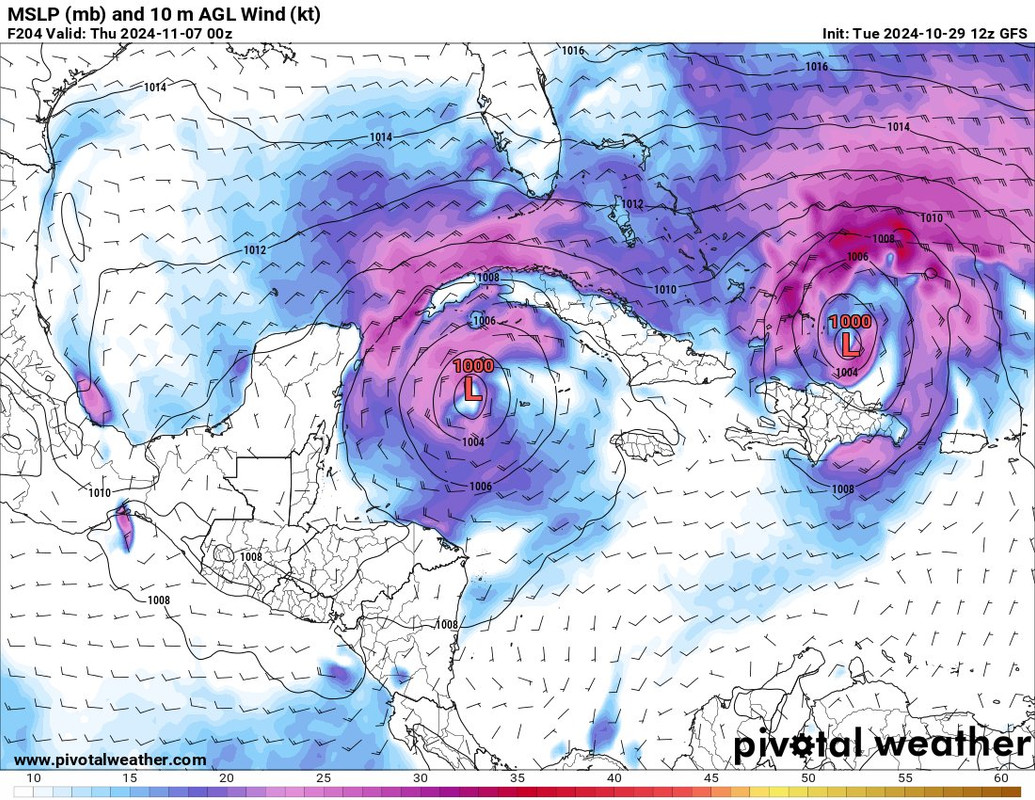
For what it's worth, the most recent 3 ICON (12Z & 0Z) model runs are now holding fast to a Nov 4/5 time frame. The operational GFS no longer depicts a 1000 mb low on or prior to Nov 5 and seems to be having a harder time resolving development details in part as a result of the broader gyre/pattern it's forecasting to evolve. The EURO seems to be battling the same complexity of conditions.

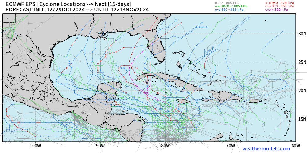
Personally, i'd throw out anything random that the CMC forecasts. I'd give the ICON some credence in light of recent storm model forecast history, especially if picking up on what could be a smaller meso-scale development. Will be interesting to see whether GFS & EURO ensembles tend to increase or back off their signal for development prior to Nov 6. I would have thought that any added "juice" toward genesis given the forecast MJO signal would have begun or occurred by that date.
0 likes   
Andy D

(For official information, please refer to the NHC and NWS products.)

User avatar
chaser1
S2K Supporter
S2K Supporter
Posts: 5464
Age: 64
Joined: Sat Oct 15, 2005 5:59 pm
Location: Longwood, Fl

Re: Low Pressure to develop in the Southwest Caribbean Sea (0/40)

#146 Postby chaser1 » Tue Oct 29, 2024 11:34 am

wzrgirl1 wrote:
chaser1 wrote:
AnnularCane wrote:

Wasn't it supposed to develop this week?


The GFS recently had gone on a pretty steady roll of consecutive forecasts depicting development of a TS on November 1st. I was subjectively basing that off the forecast time at the point when the model first depicted a 1000 mb low for this disturbance. The 0Z from last night went all the way out to Nov 5 however and then the 6Z this a.m. came back with development on Nov 2, so there is some variability here. Naturally, this is simply "one tool" and no individual model should ever be viewed literally. We'll see if the 12Z run rolling out now more or less reverts to forecasting a 1000 mb low in the Caribbean around the Nov 1/2 time frame, or whether the GFS and other Globals push back development a few days further out. The various ensembles are probably the best tool to determine whether the time frame seems to move closer or if the goal posts are indeed getting further pushed back. One thing I am beginning to see though is that both the GFS and EURO seem to be backing off on any near-term progression of any strong cold front/sharp trough down toward the N. GOM. Seems like the tropics are still trying to enforce its Easterlies pattern just a little bit longer. Whether this verifies will have a lot to do with near to mid-term storm track in the event something does form in the next 4-8 days. Beyond that, steering is just too hard to forecast during this seasonal transition.


November 1st is only 3 days away. :double:


Yep. I think its pretty apparent that we're not going to see any development any earlier than Nov 4. Whether shortly thereafter is a waiting game. That's why I hate model forecasts and much prefer to be eye-balling an existing disturbance 8-)
0 likes   
Andy D

(For official information, please refer to the NHC and NWS products.)

User avatar
chaser1
S2K Supporter
S2K Supporter
Posts: 5464
Age: 64
Joined: Sat Oct 15, 2005 5:59 pm
Location: Longwood, Fl

Re: Low Pressure to develop in the Southwest Caribbean Sea (0/40)

#147 Postby chaser1 » Tue Oct 29, 2024 11:38 am


Gets even wilder at 234 hr. Mid level high over deepening twins LOL
0 likes   
Andy D

(For official information, please refer to the NHC and NWS products.)

User avatar
SFLcane
S2K Supporter
S2K Supporter
Posts: 10163
Age: 47
Joined: Sat Jun 05, 2010 1:44 pm
Location: Lake Worth Florida

Re: Low Pressure to develop in the Southwest Caribbean Sea (0/40)

#148 Postby SFLcane » Tue Oct 29, 2024 11:40 am

12z models ramping up this afternoon with diffirent solutions. :lol:
Last edited by SFLcane on Tue Oct 29, 2024 12:16 pm, edited 1 time in total.
0 likes   

User avatar
kevin
Category 5
Category 5
Posts: 2586
Age: 26
Joined: Wed Aug 28, 2019 4:35 am

Re: Low Pressure to develop in the Southwest Caribbean Sea (0/40)

#149 Postby kevin » Tue Oct 29, 2024 12:04 pm

Dual hurricanes in the Atlantic, why not it's only November...

Image
3 likes   

User avatar
WaveBreaking
Category 2
Category 2
Posts: 578
Joined: Sun Jun 30, 2024 11:33 am
Location: US

Re: Low Pressure to develop in the Southwest Caribbean Sea (0/40)

#150 Postby WaveBreaking » Tue Oct 29, 2024 12:32 pm

kevin wrote:Dual hurricanes in the Atlantic, why not it's only November...

https://i.imgur.com/cSwi84Q.png


The Day After Tomorrow-type situation in November. Why not :lol:
1 likes   
I am NOT a professional meteorologist, so take all of my posts with a grain of salt. My opinions are mine and mine alone.

User avatar
cycloneye
Admin
Admin
Posts: 145277
Age: 68
Joined: Thu Oct 10, 2002 10:54 am
Location: San Juan, Puerto Rico

Re: Low Pressure to develop in the Southwest Caribbean Sea (0/40)

#151 Postby cycloneye » Tue Oct 29, 2024 1:11 pm

Tropical Weather Outlook
NWS National Hurricane Center Miami FL
200 PM EDT Tue Oct 29 2024

For the North Atlantic...Caribbean Sea and the Gulf of Mexico:

1. Southwestern Caribbean Sea:
A broad area of low pressure is likely to develop over the
southwestern Caribbean Sea in a couple of days. Gradual development
is possible thereafter, and a tropical depression could form over
the weekend while the system begins to drift northward or
northeastward toward the central Caribbean Sea.
* Formation chance through 48 hours...low...near 0 percent.
* Formation chance through 7 days...medium...40 percent.


Forecaster Hagen
0 likes   
Visit the Caribbean-Central America Weather Thread where you can find at first post web cams,radars
and observations from Caribbean basin members Click Here

User avatar
kevin
Category 5
Category 5
Posts: 2586
Age: 26
Joined: Wed Aug 28, 2019 4:35 am

Re: Low Pressure to develop in the Southwest Caribbean Sea (0/40)

#152 Postby kevin » Tue Oct 29, 2024 1:18 pm

12z Euro with a TS near Yucatan at +240 hours, 1002 mb and further west than 00z.

Image
1 likes   

Michele B
S2K Supporter
S2K Supporter
Posts: 1114
Joined: Thu Aug 25, 2016 8:08 am
Location: SWFL

Re: Low Pressure to develop in the Southwest Caribbean Sea (0/40)

#153 Postby Michele B » Tue Oct 29, 2024 1:22 pm

kevin wrote:Dual hurricanes in the Atlantic, why not it's only November...

https://i.imgur.com/cSwi84Q.png


We’ll, if there’s one thing we know about 2024, it’s to expect *anything*
2 likes   
Cleo - 1964, Betsy - 1965, David - 1979, Andrew - 1992, Charlie (Francis, Ivan, Jeanne) - 2004, Irma - 2017, Ian - 2022

User avatar
blp
Category 5
Category 5
Posts: 2840
Age: 46
Joined: Thu Sep 09, 2004 7:51 pm
Location: Miami, FL
Contact:

Re: Low Pressure to develop in the Southwest Caribbean Sea (0/40)

#154 Postby blp » Tue Oct 29, 2024 1:53 pm

Being by the Yucatan is a dangerous spot. Looks like there won't enough of a ridge to drive into Mexico. It will be far enough north waiting for the next shortwave to bring it up.

Euro
Image

GFS
Image
0 likes   
The following post is NOT an official forecast and should not be used as such. It is just the opinion of the poster and may or may not be backed by sound meteorological data. It is NOT endorsed by any professional institution including storm2k.org For Official Information please refer to the NHC and NWS products.

User avatar
SFLcane
S2K Supporter
S2K Supporter
Posts: 10163
Age: 47
Joined: Sat Jun 05, 2010 1:44 pm
Location: Lake Worth Florida

Re: Low Pressure to develop in the Southwest Caribbean Sea (0/40)

#155 Postby SFLcane » Tue Oct 29, 2024 1:58 pm

12z EPS has a strong signal in the NW caribbean.

Image
6 likes   

User avatar
Ivanhater
Storm2k Moderator
Storm2k Moderator
Posts: 11160
Age: 38
Joined: Fri Jul 01, 2005 8:25 am
Location: Pensacola

Re: Low Pressure to develop in the Southwest Caribbean Sea (0/40)

#156 Postby Ivanhater » Tue Oct 29, 2024 2:27 pm

That is a shocking number of Euro ensembles that go deep into the Gulf of Mexico in November.

Not surprising though. Strong high pressure has made it well above normal along the northern gulf. 80s and close to 90 last few weeks
3 likes   
Michael

xironman
S2K Supporter
S2K Supporter
Posts: 2522
Joined: Sun Jun 10, 2007 4:53 pm
Location: NoVA

Re: Low Pressure to develop in the Southwest Caribbean Sea (0/40)

#157 Postby xironman » Tue Oct 29, 2024 3:51 pm

Michele B wrote:
kevin wrote:Dual hurricanes in the Atlantic, why not it's only November...

https://i.imgur.com/cSwi84Q.png


We’ll, if there’s one thing we know about 2024, it’s to expect *anything*


That and 57 will lose the office poll
4 likes   

User avatar
SFLcane
S2K Supporter
S2K Supporter
Posts: 10163
Age: 47
Joined: Sat Jun 05, 2010 1:44 pm
Location: Lake Worth Florida

Re: Low Pressure to develop in the Southwest Caribbean Sea (0/40)

#158 Postby SFLcane » Tue Oct 29, 2024 4:17 pm

Nhc eventually might want consider moving that development graphic westward.
0 likes   

User avatar
Hurricane2022
Category 5
Category 5
Posts: 1541
Joined: Tue Aug 23, 2022 11:38 pm
Location: Araçatuba, Brazil

Re: Low Pressure to develop in the Southwest Caribbean Sea (0/40)

#159 Postby Hurricane2022 » Tue Oct 29, 2024 4:27 pm

xironman wrote:
Michele B wrote:
kevin wrote:Dual hurricanes in the Atlantic, why not it's only November...

https://i.imgur.com/cSwi84Q.png


We’ll, if there’s one thing we know about 2024, it’s to expect *anything*


That and 57 will lose the office poll

Let us agree that losing an office poll is a canonical event in the life of any man in his work environment. It's always bad to lose but it's nice for fun. but either way this is the kind of bet I would hardly expect to lose :eek: ...2024 is still being 2024 unfortunately.
0 likes   
Sorry for the bad English sometimes...!
For reliable and detailed information for any meteorological phenomenon, please consult the National Hurricane Center, Joint Typhoon Warning Center , or your local Meteo Center.

--------

Una cvm Christo, pro Christo, et in Christo. Sit nomen Domini benedictvm.

User avatar
cycloneye
Admin
Admin
Posts: 145277
Age: 68
Joined: Thu Oct 10, 2002 10:54 am
Location: San Juan, Puerto Rico

Re: Low Pressure to develop in the Southwest Caribbean Sea (0/40)

#160 Postby cycloneye » Tue Oct 29, 2024 6:31 pm

No change with that 40%, but the development area changed a bit.

Tropical Weather Outlook
NWS National Hurricane Center Miami FL
800 PM EDT Tue Oct 29 2024

For the North Atlantic...Caribbean Sea and the Gulf of Mexico:

Southwestern Caribbean Sea:
A broad area of low pressure is likely to develop over the
southwestern Caribbean Sea in a couple of days. Gradual development
is possible thereafter, and a tropical depression could form over
the weekend while the system drifts generally northward over the
west-central Caribbean Sea.
* Formation chance through 48 hours...low...near 0 percent.
* Formation chance through 7 days...medium...40 percent.

$$
Forecaster Pasch


Image
1 likes   
Visit the Caribbean-Central America Weather Thread where you can find at first post web cams,radars
and observations from Caribbean basin members Click Here


Return to “Talkin' Tropics”

Who is online

Users browsing this forum: AnnularCane, Hypercane_Kyle, RomP and 28 guests