https://twitter.com/DerekOrtt/status/1147918376024596481
Watching GOM for tropical development (Is INVEST 92L)
Moderator: S2k Moderators
Forum rules

The posts in this forum are NOT official forecasts and should not be used as such. They are just the opinion of the poster and may or may not be backed by sound meteorological data. They are NOT endorsed by any professional institution or STORM2K. For official information, please refer to products from the National Hurricane Center and National Weather Service.
-
cycloneye

- Admin

- Posts: 149736
- Age: 69
- Joined: Thu Oct 10, 2002 10:54 am
- Location: San Juan, Puerto Rico
Re: Watching NE GOM for tropical development
4 likes
Visit the Caribbean-Central America Weather Thread where you can find at first post web cams,radars
and observations from Caribbean basin members Click Here
and observations from Caribbean basin members Click Here
-
Aric Dunn
- Category 5

- Posts: 21238
- Age: 43
- Joined: Sun Sep 19, 2004 9:58 pm
- Location: Ready for the Chase.
- Contact:
Re: Watching NE GOM for tropical development
UKMET again more detail. coming inline with Euro.

0 likes
Note: If I make a post that is brief. Please refer back to previous posts for the analysis or reasoning. I do not re-write/qoute what my initial post said each time.
If there is nothing before... then just ask
Space & Atmospheric Physicist, Embry-Riddle Aeronautical University,
I believe the sky is falling...
If there is nothing before... then just ask
Space & Atmospheric Physicist, Embry-Riddle Aeronautical University,
I believe the sky is falling...
-
cycloneye
- Admin
- Posts: 149736
- Age: 69
- Joined: Thu Oct 10, 2002 10:54 am
- Location: San Juan, Puerto Rico
Re: Watching NE GOM for tropical development
Tropical Weather Outlook
NWS National Hurricane Center Miami FL
200 PM EDT Sun Jul 7 2019
For the North Atlantic...Caribbean Sea and the Gulf of Mexico:
A trough of low pressure over the southeastern United States is
forecast to move southward toward the northeastern Gulf of Mexico,
where a broad low pressure area will likely form in a few days.
Thereafter, upper-level winds support gradual development, and a
tropical depression could form late week while the low meanders near
the northeastern Gulf of Mexico coast through Friday. Interests
along the northern Gulf Coast and Florida peninsula should monitor
the progress of this system.
* Formation chance through 48 hours...low...near 0 percent.
* Formation chance through 5 days...medium...50 percent.
$$
Forecaster Blake


1 likes
Visit the Caribbean-Central America Weather Thread where you can find at first post web cams,radars
and observations from Caribbean basin members Click Here
and observations from Caribbean basin members Click Here
-
ColdMiser123

- Professional-Met

- Posts: 905
- Age: 29
- Joined: Mon Sep 26, 2016 3:26 pm
- Location: Northeast US
Re: Watching NE GOM for tropical development
Some pretty significant differences with the evolution of the trough to the north between UKMET runs, which allows for the potential disturbance to stay in the Gulf longer, hence a stronger, further west solution. Looking at the 588 dm 500 hPa contour, the trough at 0z on the UKMET had a larger north-south amplitude across the Southeast, which allowed the system to drift north sooner, and spend less time over the Gulf.

At 12z, the 588 dm contour over the Southeast was significantly further north, which allowed for more of a westward component before turning to the north at the end of the run. The trough closing off had a role with the limited meridional amplitude this run.

This trough originates from a poorly sampled region right now, so I wouldn't favor any particular solution at this time, just that everyone along the Gulf Coast should monitor the progression of this.
At 12z, the 588 dm contour over the Southeast was significantly further north, which allowed for more of a westward component before turning to the north at the end of the run. The trough closing off had a role with the limited meridional amplitude this run.
This trough originates from a poorly sampled region right now, so I wouldn't favor any particular solution at this time, just that everyone along the Gulf Coast should monitor the progression of this.
3 likes
B.S., M.S., Meteorology & Atmospheric Science
-
northjaxpro

- S2K Supporter

- Posts: 8900
- Joined: Mon Sep 27, 2010 11:21 am
- Location: Jacksonville, FL
Re: Watching NE GOM for tropical development
Impressive vorticity signature over Northern Alabama/ NE MS currently on WV Imagery. It is moving south/southeast. This should reach the Apalachee Bay/Northeast GOM within the next 24 -30 hours. I have pretty good confidence that this will get trigger development into the Gulf. How far south it gets down into the GOM and the intensity and track are the big questions going forward.

Last edited by northjaxpro on Sun Jul 07, 2019 12:45 pm, edited 1 time in total.
4 likes
NEVER, EVER SAY NEVER in the tropics and weather in general, and most importantly, with life itself!!
________________________________________________________________________________________
Fay 2008 Beryl 2012 Debby 2012 Colin 2016 Hermine 2016 Julia 2016 Matthew 2016 Irma 2017 Dorian 2019
________________________________________________________________________________________
Fay 2008 Beryl 2012 Debby 2012 Colin 2016 Hermine 2016 Julia 2016 Matthew 2016 Irma 2017 Dorian 2019
-
LeonardRay
- Tropical Low

- Posts: 38
- Joined: Tue Aug 22, 2017 3:24 pm
Re: Watching NE GOM for tropical development
northjaxpro wrote:Impressive vorticity signature over Northern Alabama/ NE MS currently on WV Imagery. It is moving south/southeast. This should reach the Apalachee Bay/Northeast GOM within the next 24 -30 hours. I have pretty good confidence that this will get trigger development into the Gulf. How far south it gets down into the GOM and the intensity and track are the big questions going forth.
https://cdn.star.nesdis.noaa.gov/GOES16/ABI/GIFS/GOES16-GM-08-1000x1000.gif
What effect would that upper low down in the sw gulf, bay of campeche have ?
0 likes
-
cycloneye
- Admin
- Posts: 149736
- Age: 69
- Joined: Thu Oct 10, 2002 10:54 am
- Location: San Juan, Puerto Rico
Re: Watching NE GOM for tropical development: 2 PM TWO=0%/50%
0 likes
Visit the Caribbean-Central America Weather Thread where you can find at first post web cams,radars
and observations from Caribbean basin members Click Here
and observations from Caribbean basin members Click Here

Re: Watching NE GOM for tropical development
NDG wrote:Very clearly the mid to lower level vorticity is seen on satellite and 12z sounding, forecasted to track towards the NE GOM, A lot people are already looking at the NE GOM this morning but there is nothing but a surface trough at the moment.
https://i.imgur.com/AhBsRMi.gif
https://i.imgur.com/TtRY1Fm.gif
https://i.imgur.com/E3dYCED.gif
Without a doubt, it's very origin makes any evolution of this feature rather fascinating to watch! From a meteorology nerd perspective, I'd rather enjoy seeing this be forecasted in advance and then actually attain "legit" T.S. organization and intensity. Do I think it'll legitimately develop into a T.D.?? Nope. 'Course, that wont mean NHC won't tag it with a name LOL). As Jax previously mentioned above, more importantly is the potential flooding impact that this event could have on one or more regions (depending on how it all plays out). I tend to think Crownweather is right and what we'll see play out will likely be a compromise between what each of the EURO and GFS models are hedging toward; basically a
 (crapper) with too little time over water to warrant serious concern but probably a weather event that could cause serious flooding for a number of counties. I think the worse case risk would be to area's still recovering from Michael and especially those river regions that have been historically prone to cause overflow flooding.
 Beyond that hey... "it's July" and I highly doubt there'll be anything else to potentially develop south of 25N for the foreseeable future, during a year which I still think will largely under-perform (in numbers and in ACE). So, why not geek-out on a potential tropical disturbance that originated near Kansas? At least there's a potential disturbance to watch less likely to be hampered by SAL or ENSO-like upper level shear
0 likes
Andy D
(For official information, please refer to the NHC and NWS products.)
(For official information, please refer to the NHC and NWS products.)
-
cycloneye
- Admin
- Posts: 149736
- Age: 69
- Joined: Thu Oct 10, 2002 10:54 am
- Location: San Juan, Puerto Rico
Re: Watching NE GOM for tropical development
Great discussion twitter thread from Levi Cowan.
https://twitter.com/TropicalTidbits/status/1147928654363734017
https://twitter.com/TropicalTidbits/status/1147928664933392384
https://twitter.com/TropicalTidbits/status/1147928667072466946
https://twitter.com/TropicalTidbits/status/1147928654363734017
https://twitter.com/TropicalTidbits/status/1147928664933392384
https://twitter.com/TropicalTidbits/status/1147928667072466946
3 likes
Visit the Caribbean-Central America Weather Thread where you can find at first post web cams,radars
and observations from Caribbean basin members Click Here
and observations from Caribbean basin members Click Here
-
northjaxpro
- S2K Supporter
- Posts: 8900
- Joined: Mon Sep 27, 2010 11:21 am
- Location: Jacksonville, FL
Re: Watching NE GOM for tropical development
Chaser1, we may possibly be looking at a situation like Debby 2012 up this way. It definitely is on the table for sure. We will know more in the details in the next 24-36 hours. But, most certainly, plenty of rain/potential flooding for some areas are possible as the week progresses.
Last edited by northjaxpro on Sun Jul 07, 2019 1:11 pm, edited 2 times in total.
0 likes
NEVER, EVER SAY NEVER in the tropics and weather in general, and most importantly, with life itself!!
________________________________________________________________________________________
Fay 2008 Beryl 2012 Debby 2012 Colin 2016 Hermine 2016 Julia 2016 Matthew 2016 Irma 2017 Dorian 2019
________________________________________________________________________________________
Fay 2008 Beryl 2012 Debby 2012 Colin 2016 Hermine 2016 Julia 2016 Matthew 2016 Irma 2017 Dorian 2019
-
Aric Dunn
- Category 5
- Posts: 21238
- Age: 43
- Joined: Sun Sep 19, 2004 9:58 pm
- Location: Ready for the Chase.
- Contact:
Re: Watching NE GOM for tropical development
cycloneye wrote:Great discussion twitter thread from Levi Cowan.
https://twitter.com/TropicalTidbits/status/1147928654363734017
https://twitter.com/TropicalTidbits/status/1147928664933392384
https://twitter.com/TropicalTidbits/status/1147928667072466946
Yeah, thats about right.. and speaking of west short term motion to the vort.. the Euro is showing less of a hook and more a straight shot to the gulf. well over water in 72 hours..
0 likes
Note: If I make a post that is brief. Please refer back to previous posts for the analysis or reasoning. I do not re-write/qoute what my initial post said each time.
If there is nothing before... then just ask
Space & Atmospheric Physicist, Embry-Riddle Aeronautical University,
I believe the sky is falling...
If there is nothing before... then just ask
Space & Atmospheric Physicist, Embry-Riddle Aeronautical University,
I believe the sky is falling...
-
Aric Dunn
- Category 5
- Posts: 21238
- Age: 43
- Joined: Sun Sep 19, 2004 9:58 pm
- Location: Ready for the Chase.
- Contact:
Re: Watching NE GOM for tropical development
Still diving sw at 96 hours.. going to texas this time ?
0 likes
Note: If I make a post that is brief. Please refer back to previous posts for the analysis or reasoning. I do not re-write/qoute what my initial post said each time.
If there is nothing before... then just ask
Space & Atmospheric Physicist, Embry-Riddle Aeronautical University,
I believe the sky is falling...
If there is nothing before... then just ask
Space & Atmospheric Physicist, Embry-Riddle Aeronautical University,
I believe the sky is falling...

Re: Watching NE GOM for tropical development
At 96 hours the Euro seems like it's about to go beast mode.. way into the Gulf
0 likes
-
stormlover2013
Re: Watching NE GOM for tropical development
Aric Dunn wrote:Still diving sw at 96 hours.. going to texas this time ?
No way Texas lol, saying New Orleans then will feel weakness then ne ne
0 likes
-
Aric Dunn
- Category 5
- Posts: 21238
- Age: 43
- Joined: Sun Sep 19, 2004 9:58 pm
- Location: Ready for the Chase.
- Contact:
Re: Watching NE GOM for tropical development
stormlover2013 wrote:Aric Dunn wrote:Still diving sw at 96 hours.. going to texas this time ?
No way Texas lol, saying New Orleans then will feel weakness then ne ne
ridging is building in... and it had a lot of members into texas..
https://www.tropicaltidbits.com/analysi ... 0712&fh=96
0 likes
Note: If I make a post that is brief. Please refer back to previous posts for the analysis or reasoning. I do not re-write/qoute what my initial post said each time.
If there is nothing before... then just ask
Space & Atmospheric Physicist, Embry-Riddle Aeronautical University,
I believe the sky is falling...
If there is nothing before... then just ask
Space & Atmospheric Physicist, Embry-Riddle Aeronautical University,
I believe the sky is falling...

Re: Watching NE GOM for tropical development
UK met seems to only go as far west as 86.2 which is roughly on a parallel with Grayton Beach in Walton Co. That’s the 4th county east of the AL/FL border. So that’s a benchmark for the UK as of now.
0 likes

-
Aric Dunn
- Category 5
- Posts: 21238
- Age: 43
- Joined: Sun Sep 19, 2004 9:58 pm
- Location: Ready for the Chase.
- Contact:
Re: Watching NE GOM for tropical development
yeah, looks like its on a western LA eastern Texas track.. and deepening.
0 likes
Note: If I make a post that is brief. Please refer back to previous posts for the analysis or reasoning. I do not re-write/qoute what my initial post said each time.
If there is nothing before... then just ask
Space & Atmospheric Physicist, Embry-Riddle Aeronautical University,
I believe the sky is falling...
If there is nothing before... then just ask
Space & Atmospheric Physicist, Embry-Riddle Aeronautical University,
I believe the sky is falling...
-
TheProfessor

- Professional-Met
- Posts: 3506
- Age: 29
- Joined: Tue Dec 03, 2013 10:56 am
- Location: Wichita, Kansas
Re: Watching NE GOM for tropical development
quite the westward jump on the 12z Euro through hour 120.
1 likes
An alumnus of The Ohio State University.
Your local National Weather Service office is your best source for weather information.
Your local National Weather Service office is your best source for weather information.
Re: Watching NE GOM for tropical development
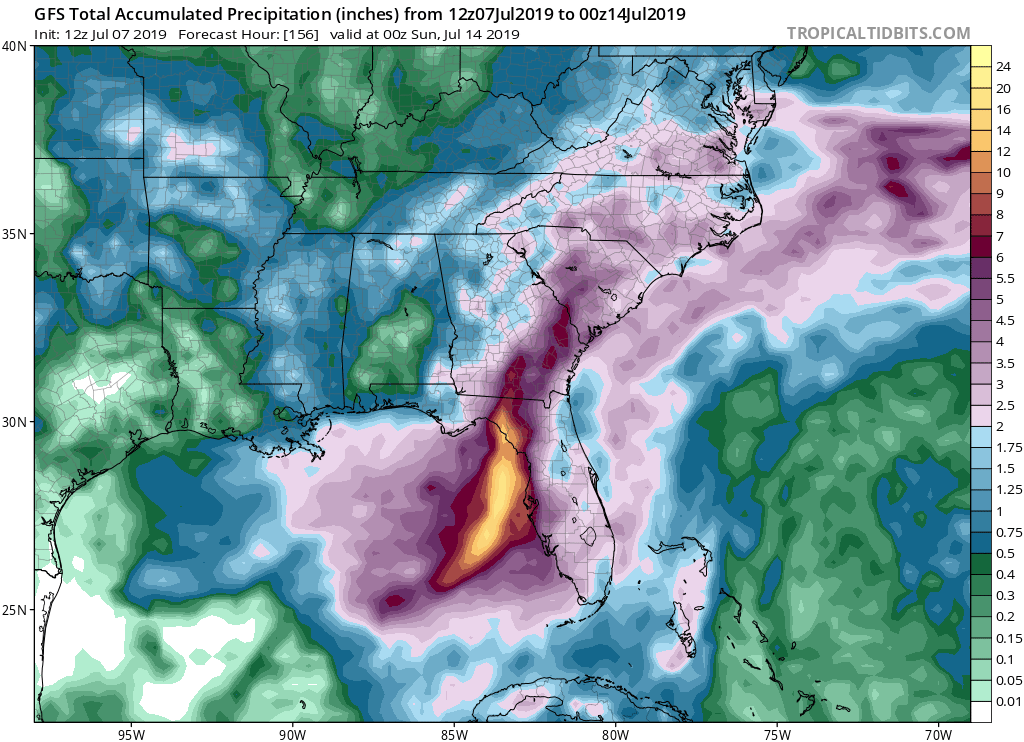
gatorcane wrote:psyclone wrote:I would lean toward a right loaded QPF bomb with most of the rain dumping on florida. Most of these systems end up weak and right and that's what is probably most likely here. If it shakes out that way it will tame the extremely warm water temps in our part of the world which is usually what eventually happens when they get out of bounds.
Yep a right loaded QPF bomb looks likely. Latest GFS has that QPF swath (20+ inches of rain) just offshore, any further east and the west coast of Florida from Tampa north would be in the bullseye. My guess is that this ends up further west than the GFS shows and more of a panhandle issue:
https://i.postimg.cc/ZnZZZ3CD/gfs-apcpn-seus-26.png
Agreed, what I've been kinda thinking as well. At least somewhat "right-loaded" and the heaviest precip training south to north into a somewhat narrow area. While I agree with Aric's point regarding lacking strong SW shear, I think all that mitigates is a broader fanned out precip impact to areas well east and northeast of any COC or trough axis. If this system were to remain weak and unable to coalesce over water, then some part of N. Florida may get drenched. What's worrisome is the increased model support for "stronger". That would likely translate to further south, more time over water, and a further west impact too.
1 likes
Andy D
(For official information, please refer to the NHC and NWS products.)
(For official information, please refer to the NHC and NWS products.)
Who is online
Users browsing this forum: No registered users and 136 guests