Fay / Cuba / Bahamas / Florida (obs / preps / reports)
Moderator: S2k Moderators
Forum rules

The posts in this forum are NOT official forecasts and should not be used as such. They are just the opinion of the poster and may or may not be backed by sound meteorological data. They are NOT endorsed by any professional institution or STORM2K. For official information, please refer to products from the National Hurricane Center and National Weather Service.

Re: TS Fay / Cuba / Bahamas / Florida (obs / preps / reports)
Heavy rain and wind 20-30 in Stuart for the last hour. Some roads flooded. First report of trees down. No reports of power out yet.
0 likes


Hey,hey!!
Sun is shining right now in Boynton Beach!!!!
Look for periodic shots of sun interrupted by a quick squall here and there for the rest of the day.
Fay helped fill the reservoirs and Lake O.
Thanks!
(not to discount the loss of life elsewhere, I am thinking only of our situation here; so PLEASE no lectures!)
0 likes
-
Canelaw99

- S2K Supporter

- Posts: 2128
- Age: 49
- Joined: Tue Aug 31, 2004 8:27 am
- Location: Homestead, FL
Re: TS Fay / Cuba / Bahamas / Florida (obs / preps / reports)
Woohoo! Winds are 26mph gusting to 40mph here in Homestead, according to weather.com...nice  Oh, and it's a bit sunny outside...nice, breezy day.
0 likes

BULLETIN - EAS ACTIVATION REQUESTED
TORNADO WARNING
NATIONAL WEATHER SERVICE MELBOURNE FL
1246 PM EDT TUE AUG 19 2008
THE NATIONAL WEATHER SERVICE IN MELBOURNE HAS ISSUED A
* TORNADO WARNING FOR...
SOUTHEASTERN INDIAN RIVER COUNTY IN EAST CENTRAL FLORIDA...
THIS INCLUDES THE CITY OF VERO BEACH SOUTH...
NORTH CENTRAL ST. LUCIE COUNTY IN EAST CENTRAL FLORIDA...
THIS INCLUDES THE CITY OF INDRIO...
* UNTIL 115 PM EDT
* AT 1245 PM EDT...NATIONAL WEATHER SERVICE DOPPLER RADAR INDICATED A
SEVERE THUNDERSTORM CAPABLE OF PRODUCING A TORNADO NEAR LAKEWOOD
PARK...OR ABOUT NEAR INDRIO...MOVING NORTHWEST AT 30 MPH.
* THE TORNADO WILL BE NEAR...
VERO BEACH SOUTH BY 1255 PM EDT...
0 likes
-
meteorologyman
- Category 2

- Posts: 541
- Joined: Wed Mar 15, 2006 6:48 pm
- Location: Florida, Kissimmee/St.CLoud
This morning I went work at 7:30am I am cartpusher at Wal-Mart. It has been Sprinkling all day, up till now the rain is getting harder located south of Orlando. I know sprinkling isn't much but it certainly adds up esp. since it's getting harder, the wind has been slowly picking up to.
It definitely surprised me to come home finding this thing finally had an eye overland. I got home around 12:3opm
It definitely surprised me to come home finding this thing finally had an eye overland. I got home around 12:3opm
0 likes
Re: TS Fay / Cuba / Bahamas / Florida (obs / preps / reports)
highlands county continuing to get soaked...wondering if I should have added a boat to my supply kit.
Supposedly the worst of it isn't dur till later this afternoon.
Should be interesting and a lesson about tropical storms.
Supposedly the worst of it isn't dur till later this afternoon.
Should be interesting and a lesson about tropical storms.
0 likes
-
meteorologyman
- Category 2
- Posts: 541
- Joined: Wed Mar 15, 2006 6:48 pm
- Location: Florida, Kissimmee/St.CLoud
-
JonathanBelles
- Professional-Met

- Posts: 11430
- Age: 35
- Joined: Sat Dec 24, 2005 9:00 pm
- Location: School: Florida State University (Tallahassee, FL) Home: St. Petersburg, Florida
- Contact:


Re: TS Fay / Cuba / Bahamas / Florida (obs / preps / reports)
Well you certainly have more sun than we do up here. No rain today unless you count the 30 second drizzle this morning. We had about 1/10" yesterday when we were moving the plants in.
0 likes
-
JonathanBelles
- Professional-Met
- Posts: 11430
- Age: 35
- Joined: Sat Dec 24, 2005 9:00 pm
- Location: School: Florida State University (Tallahassee, FL) Home: St. Petersburg, Florida
- Contact:
-
SouthFLTropics

- Category 5

- Posts: 4258
- Age: 50
- Joined: Thu Aug 14, 2003 8:04 am
- Location: Port St. Lucie, Florida
Re: TS Fay / Cuba / Bahamas / Florida (obs / preps / reports)
Here is a brief Treasure Coast Summary:
I have been out and about...Had to report in to work and my office is on the North end of South Hutchinson Island. From my office window I can see the Fort Pierce Inlet and Jetty. Of course there were idiots out on the end of the Jetty!!! Never fails...someone has to try and see what it feels like when a giant wave blasts over them.
Majority of the problems in St. Lucie County seem to be flooded roads. All during the morning we have had torrential rains. Only in the past hour has it let up some. Based on radar it appears the inner core of Fay will be moving closer to us as the evening progresses and I would expect more heavy rainfall and some decent winds. I would estimate that the winds so far were in the 40 to 50 mph range sustained with gusts close to 60 or 65 in some squalls. I did not witness very much major damage. Mainly a downed tree here or there and branches or palm fronds everywhere. Orange Avenue and 10th Street in Fort Pierce is has about a foot of water at the intersection. Seaway Drive near the intersection of Binney Drive also has substantial flooding on it. Moore Creek looks like a raging river today and it has spilled over it's banks near 7th Avenue in Fort Pierce and is flooding the roadway there. Also, Indian River Drive between Orange and Seaway Drive is under water. I have not heard of any power outages and all of the traffic signals that I passed on the way home seemed to be working. I did not witness it but I heard that Virginia Avenue @ 25th Street is impassable and that 25th is flooded between Virginia to Edwards Road. That was pretty much the extent of it. I'm sure more is to come. Stay tuned. I am back at my home in PSL and will continue to give updates when available.
That being said, Fay would have to rank in my top ten of most interesting storms to track to date. I have lived on the East Coast of Florida my entire life and I am a 4th generation Floridian. I myself, nor any of my family, can ever recall a storm like this. Interesting trackwise and now you throw on the land based intesity increase. Simply amazing. It's why we are all here. Because you never know what they are going to do and they keep you guessing.
SFT
0 likes
-
deadcities
- Tropical Low

- Posts: 24
- Joined: Sun Aug 29, 2004 10:37 pm
- Location: Chesapeake, VA
- Contact:
-
meteorologyman
- Category 2
- Posts: 541
- Joined: Wed Mar 15, 2006 6:48 pm
- Location: Florida, Kissimmee/St.CLoud
Re: TS Fay / Cuba / Bahamas / Florida (obs / preps / reports)
Heavy dark clouds/rain/wind here as stronger rain bands move in. my area is under floodwarning, dont like the fact that this thing may go back in the water then do an about face turn near my area.
0 likes

Hi All...I posted the first video in the wrong thread previously (the TS Fay inside Florida Peninsula one)...was told it might be more appropriate here, so here it is...enjoy
http://www.youtube.com/watch?v=kJf0GG-UZHw
http://www.youtube.com/watch?v=kJf0GG-UZHw
0 likes

-
O Town
- S2K Supporter
- Posts: 5205
- Age: 52
- Joined: Wed Sep 07, 2005 9:37 pm
- Location: Orlando, Florida 28°35'35"N 81°22'55"W
Finally getting some good bands coming through.
Still not much rain but wind picking up some. I am enjoying it.
Weather station link

Weather station link
Still not much rain but wind picking up some. I am enjoying it.
Weather station link
Weather station link
0 likes
-
Terry
- S2K Supporter
- Posts: 1450
- Joined: Wed Aug 11, 2004 8:25 pm
- Location: Lakeland and Anna Maria Island, FL
- Contact:
Re: TS Fay / Cuba / Bahamas / Florida (obs / preps / reports)
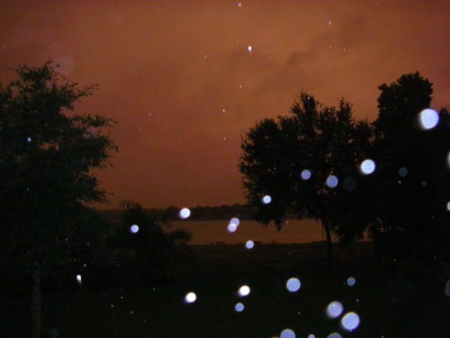
Eerie red cloud cover here in Lakeland (central FL) this evening. Like Skeet said, it looked like the California wildfires. I forgot to get a photo until it was almost gone:
0 likes
-
JonathanBelles
- Professional-Met
- Posts: 11430
- Age: 35
- Joined: Sat Dec 24, 2005 9:00 pm
- Location: School: Florida State University (Tallahassee, FL) Home: St. Petersburg, Florida
- Contact:
-
meteorologyman
- Category 2
- Posts: 541
- Joined: Wed Mar 15, 2006 6:48 pm
- Location: Florida, Kissimmee/St.CLoud
Re: TS Fay / Cuba / Bahamas / Florida (obs / preps / reports)
It hasn't stop rainning "AT ALL" since 7:30 am this morning here at Saint Cloud, I am curious how much rain ws received here, and I do recall waking up once around 5 or 6am hearing a down pour
0 likes
Who is online
Users browsing this forum: No registered users and 157 guests