ENSO Updates (2007 thru 2023)
Moderator: S2k Moderators
Forum rules

The posts in this forum are NOT official forecasts and should not be used as such. They are just the opinion of the poster and may or may not be backed by sound meteorological data. They are NOT endorsed by any professional institution or STORM2K. For official information, please refer to products from the National Hurricane Center and National Weather Service.
-
Kingarabian

- S2K Supporter

- Posts: 16367
- Joined: Sat Aug 08, 2009 3:06 am
- Location: Honolulu, Hawaii
Re: ENSO Updates
SOI dailys are going to be neutral or just slightly negative for the next 7 days. The bigger negatives from the end of June are running out so we could see the 30 day SOI climb further.
Last edited by Kingarabian on Sun Jul 16, 2023 10:04 am, edited 1 time in total.
2 likes
RIP Kobe Bryant
-
Kingarabian
- S2K Supporter
- Posts: 16367
- Joined: Sat Aug 08, 2009 3:06 am
- Location: Honolulu, Hawaii
Re: ENSO Updates
xtyphooncyclonex wrote:Latest CFSv2 shows the monthlies now going past 2C+ following a pretty substantial warming in Aug-Sep. A bit skeptical, but momentum is there oceanic-wise. What explains the poor SOI showing?
I think Dean_175 explained it pretty well a few pages back. Poor SOI showing is due to the poor atmosphere coupling. But to summarize a few things, the lack of WWBs and above average trades over the CPAC signals less than normal rising motion near the DL which is needed for a -SOI. Very warm Atlantic is also stealing some of that rising motion as well.
2 likes
RIP Kobe Bryant
Re: ENSO Updates
Today's OISST anomaly increase in Nino 3.4 of 0.76 (to +1.160) is the largest daily increase since way back on June 6th. Also, today's anomaly is the highest so far this year in regions 3.4, 3, and 1+2.
1 likes
Personal Forecast Disclaimer:
The posts in this forum are NOT official forecasts and should not be used as such. They are just the opinion of the poster and may or may not be backed by sound meteorological data. They are NOT endorsed by any professional institution or storm2k.org. For official information, please refer to the NHC and NWS products.
The posts in this forum are NOT official forecasts and should not be used as such. They are just the opinion of the poster and may or may not be backed by sound meteorological data. They are NOT endorsed by any professional institution or storm2k.org. For official information, please refer to the NHC and NWS products.
Re: ENSO Updates
xtyphooncyclonex wrote:Latest CFSv2 shows the monthlies now going past 2C+ following a pretty substantial warming in Aug-Sep. A bit skeptical, but momentum is there oceanic-wise. What explains the poor SOI showing?
Just 11 days ago, the CFS 40 run mean was only ~+1.75. The latest is way up at ~+2.07!
0 likes
Personal Forecast Disclaimer:
The posts in this forum are NOT official forecasts and should not be used as such. They are just the opinion of the poster and may or may not be backed by sound meteorological data. They are NOT endorsed by any professional institution or storm2k.org. For official information, please refer to the NHC and NWS products.
The posts in this forum are NOT official forecasts and should not be used as such. They are just the opinion of the poster and may or may not be backed by sound meteorological data. They are NOT endorsed by any professional institution or storm2k.org. For official information, please refer to the NHC and NWS products.


Re: ENSO Updates
LarryWx wrote: Today's OISST anomaly increase in Nino 3.4 of 0.76 (to +1.160) is the largest daily increase since way back on June 6th. Also, today's anomaly is the highest so far this year in regions 3.4, 3, and 1+2.
Per the TAO buoys it looks to remain the same, thus I'm going to guess another 1C reading tomorrow. The eastern regions continue to warm. This is about as east-based an El Nino as you can get, at its current state.
So far continues the theme not happening the same way we are accustomed to the past few decades with eq-cpac wind action. Different breed of El Nino going on.
6 likes
The above post and any post by Ntxw is NOT an official forecast and should not be used as such. It is just the opinion of the poster and may or may not be backed by sound meteorological data. It is NOT endorsed by any professional institution including Storm2k. For official information, please refer to NWS products.
Help support Storm2K!
-
xtyphooncyclonex

- Category 5

- Posts: 3892
- Age: 24
- Joined: Sat Dec 08, 2012 9:07 am
- Location: Cebu City
- Contact:
Re: ENSO Updates
Kingarabian wrote:I think Dean_175 explained it pretty well a few pages back. Poor SOI showing is due to the poor atmosphere coupling. But to summarize a few things, the lack of WWBs and above average trades over the CPAC signals less than normal rising motion near the DL which is needed for a -SOI. Very warm Atlantic is also stealing some of that rising motion as well.
Seeing rather unimpressive atmospheric indices and responses firsthand. While it may be early, we've had at least three different flooding events in my area when El Niño is supposed to bring strongly below-average rainfall. Weather patterns in many other places may also defy traditional patterns. It doesn't "feel" like an El Niño, but it "looks" like one because of the strong oceanic signature. It's worth noting that even as this strengthens --- the models show that precip patterns stay the same: wet all over the Philippines.
It's kinda puzzling that despite expectations of no/weak WWBs and an overall underwhelming response, the ocean seems to have weathered it well and momentum is now perhaps clearly favoring a moderate event at least. This could probably be a new breed of El Niño, no?
1 likes
REMINDER: My opinions that I, or any other NON Pro-Met in this forum, are unofficial. Please do not take my opinions as an official forecast and warning. I am NOT a meteorologist. Following my forecasts blindly may lead to false alarm, danger and risk if official forecasts from agencies are ignored.
-
cycloneye

- Admin

- Posts: 149520
- Age: 69
- Joined: Thu Oct 10, 2002 10:54 am
- Location: San Juan, Puerto Rico
Re: ENSO: CPC Weekly update of 7/17/23: Niño 1+2=+3.4C / Niño 3=+1.6C / Niño 3.4=+1.1C / Niño 4=+0.7C
The weekly update by CPC has niño 3.4 up to +1.1C, Niño 3 up to +1.6C and Niño 1+2 up to 3.4C.
https://www.cpc.ncep.noaa.gov/products/ ... ts-web.pdf
https://www.cpc.ncep.noaa.gov/products/ ... ts-web.pdf
0 likes
Visit the Caribbean-Central America Weather Thread where you can find at first post web cams,radars
and observations from Caribbean basin members Click Here
and observations from Caribbean basin members Click Here
Re: ENSO: CPC Weekly update of 7/17/23: Niño 1+2=+3.4C / Niño 3=+1.6C / Niño 3.4=+1.1C / Niño 4=+0.7C
cycloneye wrote:The weekly update by CPC has niño 3.4 up to +1.1C, Niño 3 up to +1.6C and Niño 1+2 up to 3.4C.
https://www.cpc.ncep.noaa.gov/products/ ... ts-web.pdf
Being that we are well within moderate now with enough weeks, a strong peak seems probable. Unless no warming occurs the rest of the way, which is very unlikely.
I've been using proxy of Nino 3 as precursor to 3.4 roughly a month later +/- 0.1C seems to get in the ballpark. Sometime mid August we should be approaching ~1.5C on the weeklies.
3 likes
The above post and any post by Ntxw is NOT an official forecast and should not be used as such. It is just the opinion of the poster and may or may not be backed by sound meteorological data. It is NOT endorsed by any professional institution including Storm2k. For official information, please refer to NWS products.
Help support Storm2K!
Help support Storm2K!
-
gatorcane

- S2K Supporter
- Posts: 23708
- Age: 48
- Joined: Sun Mar 13, 2005 3:54 pm
- Location: Boca Raton, FL
Re: ENSO: CPC Weekly update of 7/17/23: Niño 1+2=+3.4C / Niño 3=+1.6C / Niño 3.4=+1.1C / Niño 4=+0.7C
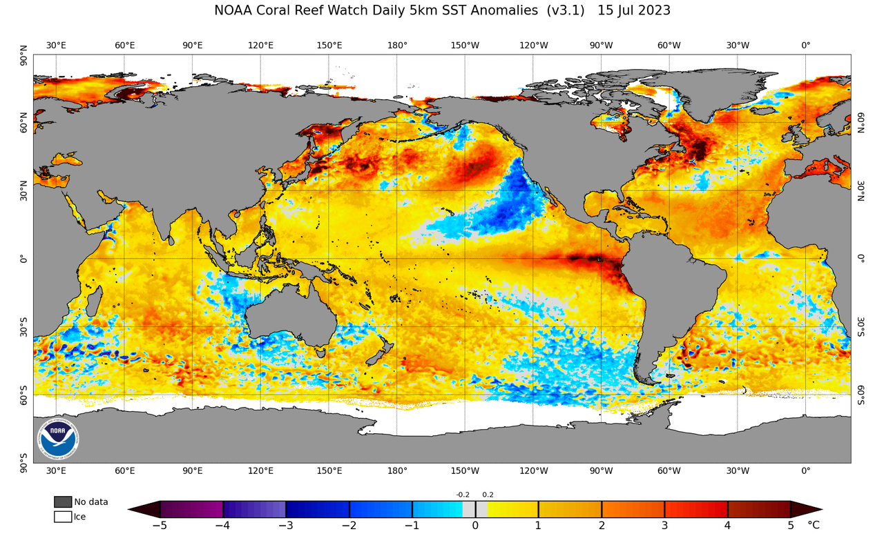
Doesn’t surprise me the Nino numbers are increasing. Just taking a look at this map says it all with deep reds expanding west over the equator south of Mexico:
2 likes
-
cycloneye
- Admin
- Posts: 149520
- Age: 69
- Joined: Thu Oct 10, 2002 10:54 am
- Location: San Juan, Puerto Rico
Re: ENSO Updates
1 likes
Visit the Caribbean-Central America Weather Thread where you can find at first post web cams,radars
and observations from Caribbean basin members Click Here
and observations from Caribbean basin members Click Here
-
Sciencerocks
- Category 5
- Posts: 10186
- Age: 40
- Joined: Thu Jul 06, 2017 1:51 am
Re: ENSO Updates
Wouldn't this cancel out a lot of the effects of the nino for the Atlantic? You know, the record warmth over the Atlantic would cause rising motion and higher instability over the basin. This could make this year active for the Atlantic.
Global warming could cause some interesting stuff.
Global warming could cause some interesting stuff.
0 likes
Re: ENSO Updates
Sciencerocks wrote:Wouldn't this cancel out a lot of the effects of the nino for the Atlantic? You know, the record warmth over the Atlantic would cause rising motion and higher instability over the basin. This could make this year active for the Atlantic.
Global warming could cause some interesting stuff.
It's more than just that. The Atlantic isn't the only region experiencing abnormally warm waters. Many of the oceans are, the WPAC warm pool has been at record levels for years, does that yank from Atlantic warmth and rising motion? Does forcing then separate to many places, if so how does that change the circulations? So is the Indian Ocean and so on...with many mixed signals, we just have a hard time predicting what's going to happen because they don't happen like they do in the past.
5 likes
The above post and any post by Ntxw is NOT an official forecast and should not be used as such. It is just the opinion of the poster and may or may not be backed by sound meteorological data. It is NOT endorsed by any professional institution including Storm2k. For official information, please refer to NWS products.
Help support Storm2K!
Help support Storm2K!
-
Iceresistance

- Category 5
- Posts: 9593
- Age: 22
- Joined: Sat Oct 10, 2020 9:45 am
- Location: Tecumseh, OK/Norman, OK
Re: ENSO Updates
Ntxw wrote:Sciencerocks wrote:Wouldn't this cancel out a lot of the effects of the nino for the Atlantic? You know, the record warmth over the Atlantic would cause rising motion and higher instability over the basin. This could make this year active for the Atlantic.
Global warming could cause some interesting stuff.
It's more than just that. The Atlantic isn't the only region experiencing abnormally warm waters. Many of the oceans are, the WPAC warm pool has been at record levels for years, does that yank from Atlantic warmth and rising motion? Does forcing then separate to many places, if so how does that change the circulations? So is the Indian Ocean and so on...with many mixed signals, we just have a hard time predicting what's going to happen because they don't happen like they do in the past.
My only logical conclusion on why the entire earth is above normal in temperatures compared to the past few years is something to do with the Tonga Volcano that spewed out so much water vapor.
Increased water vapor increases the moisture capacity, which allows for higher temperatures, higher humidity, and more (and stronger) storms
4 likes
Bill 2015 & Beta 2020
Winter 2020-2021
All observations are in Tecumseh, OK unless otherwise noted.
Winter posts are focused mainly for Oklahoma & Texas.
Take any of my forecasts with a grain of salt, refer to the NWS, SPC, and NHC for official information
Never say Never with weather! Because ANYTHING is possible!
Winter 2020-2021
All observations are in Tecumseh, OK unless otherwise noted.
Winter posts are focused mainly for Oklahoma & Texas.
Take any of my forecasts with a grain of salt, refer to the NWS, SPC, and NHC for official information
Never say Never with weather! Because ANYTHING is possible!
Re: ENSO Updates
Barring some weird reversal, the next update should see another bump upward. The east continues to warm with the latest buoys.

1 likes
The above post and any post by Ntxw is NOT an official forecast and should not be used as such. It is just the opinion of the poster and may or may not be backed by sound meteorological data. It is NOT endorsed by any professional institution including Storm2k. For official information, please refer to NWS products.
Help support Storm2K!
Help support Storm2K!
-
cycloneye
- Admin
- Posts: 149520
- Age: 69
- Joined: Thu Oct 10, 2002 10:54 am
- Location: San Juan, Puerto Rico
Re: ENSO Updates
https://twitter.com/WxPatel/status/1681813905675284480
@WxPatel
As the MJO slowly moves eastward through the Pacific, it will induce a significant WWB across all ENSO regions starting late month. Weak trades will promote warming that will likely push this El Niño event into the strong tier (> 1.5C for ENSO 3.4).
As the MJO slowly moves eastward through the Pacific, it will induce a significant WWB across all ENSO regions starting late month. Weak trades will promote warming that will likely push this El Niño event into the strong tier (> 1.5C for ENSO 3.4).
0 likes
Visit the Caribbean-Central America Weather Thread where you can find at first post web cams,radars
and observations from Caribbean basin members Click Here
and observations from Caribbean basin members Click Here
-
Kingarabian
- S2K Supporter
- Posts: 16367
- Joined: Sat Aug 08, 2009 3:06 am
- Location: Honolulu, Hawaii
Re: ENSO Updates
cycloneye wrote:https://twitter.com/WxPatel/status/1681813905675284480@WxPatel
As the MJO slowly moves eastward through the Pacific, it will induce a significant WWB across all ENSO regions starting late month. Weak trades will promote warming that will likely push this El Niño event into the strong tier (> 1.5C for ENSO 3.4).
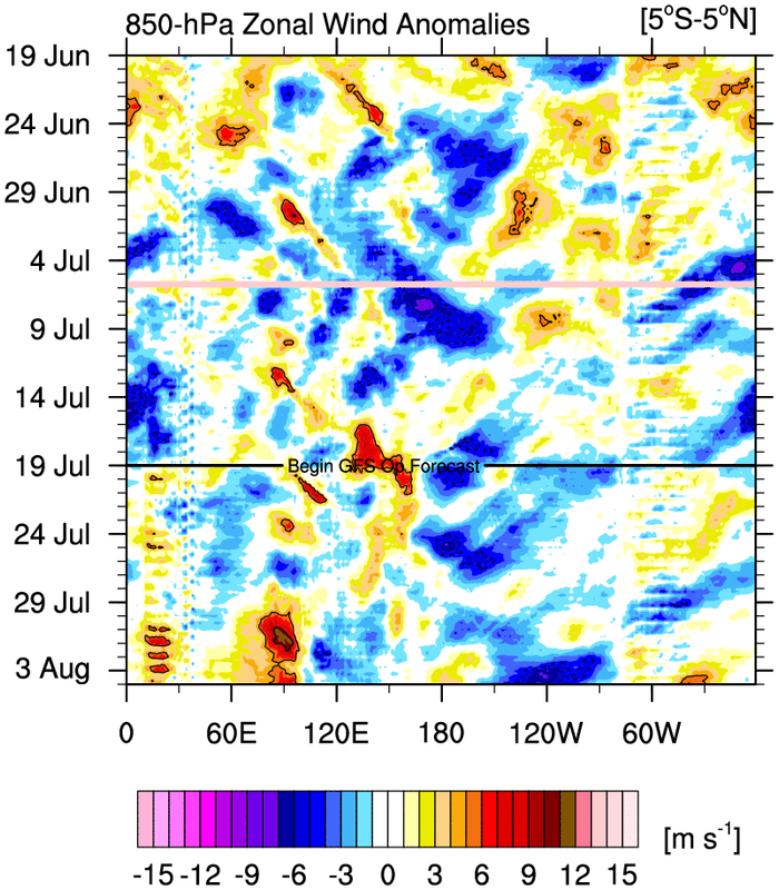
Not sure why the 850mb wind anomalies from 15N to 15S keep being used for ENSO.
1 likes
RIP Kobe Bryant
-
Kingarabian
- S2K Supporter
- Posts: 16367
- Joined: Sat Aug 08, 2009 3:06 am
- Location: Honolulu, Hawaii
-
Iceresistance
- Category 5
- Posts: 9593
- Age: 22
- Joined: Sat Oct 10, 2020 9:45 am
- Location: Tecumseh, OK/Norman, OK
Re: ENSO Updates
9-Day streak of -SOI is finally starting to bring down the 30-Day SOI values.
1 likes
Bill 2015 & Beta 2020
Winter 2020-2021
All observations are in Tecumseh, OK unless otherwise noted.
Winter posts are focused mainly for Oklahoma & Texas.
Take any of my forecasts with a grain of salt, refer to the NWS, SPC, and NHC for official information
Never say Never with weather! Because ANYTHING is possible!
Winter 2020-2021
All observations are in Tecumseh, OK unless otherwise noted.
Winter posts are focused mainly for Oklahoma & Texas.
Take any of my forecasts with a grain of salt, refer to the NWS, SPC, and NHC for official information
Never say Never with weather! Because ANYTHING is possible!


Re: ENSO Updates
Stabilizing or equalizing? No way could that kind of rising air over the Epac result in a "stabilizing affect" (at least not for that region). Naturally I would think that this kind of lifting air would go hand in hand with lower SSP's, but I havn't been really paying attention whether EPac surface pressures have been anomalously high thus far or not.
0 likes
Andy D
(For official information, please refer to the NHC and NWS products.)
(For official information, please refer to the NHC and NWS products.)
Who is online
Users browsing this forum: Old-TimeCane and 136 guests