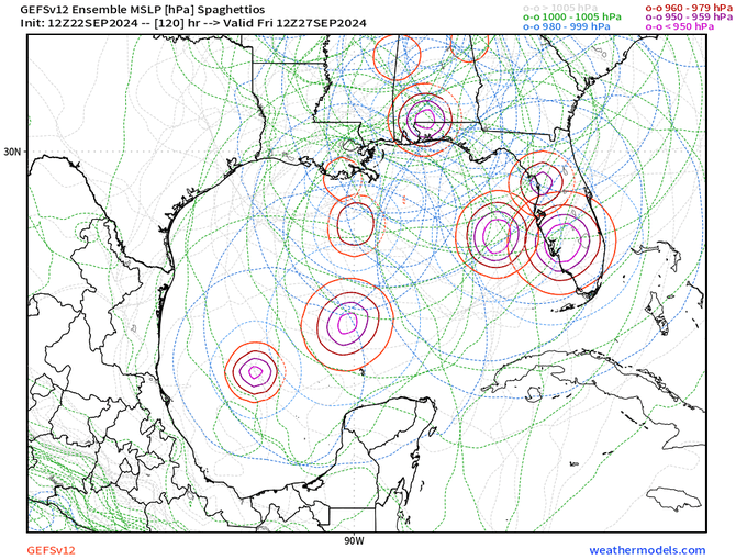
Low pressure developing over the western Caribbean Sea (Is Invest 97L)

This is the general tropical discussion area. Anyone can take their shot at predicting a storms path.

Moderator: S2k Moderators

Forum rules

The posts in this forum are NOT official forecasts and should not be used as such. They are just the opinion of the poster and may or may not be backed by sound meteorological data. They are NOT endorsed by any professional institution or STORM2K. For official information, please refer to products from the National Hurricane Center and National Weather Service.

Help Support Storm2K
Message
Author
User avatar
ConvergenceZone
Category 5
Category 5
Posts: 5194
Joined: Fri Jul 29, 2005 1:40 am
Location: Northern California

Re: Low pressure developing over the western Caribbean Sea (10/70)

#1281 Postby ConvergenceZone » Sun Sep 22, 2024 1:01 pm

psyclone wrote:
ConvergenceZone wrote:As someone pointed out earlier is that this system will be moving at an absolute lightning speed. While that's bad for preparation, it should be over just a few short hours after it begins, thus a short duration event. Also, will have much less time to get really strong.


Can you define "lightning speed"...I'm not seeing that. I do see plenty of solutions...some of which are very strong. If a system organizes it can intensify very rapidly if the stars align. OHC in the Gulf and Caribbean is record highs for this date per McNoldy's data. Otis went from a cat 1 to a 5 in 12 hours last year with similar rocket fuel. Explosive development should be a consideration even if that outcome isn't most likely.


I just go by where the models are showing the system every 6 hours. Also remember this system initially didn't suppose to hit land until next Sunday or Monday and now it's showing late Thursday and Friday. That's quite a difference in speed. I mean to get from where it is right now to the north gulf coast in only 4 and 1/2 to 5 days can only happen with a very quick mover. And that's also probably why the other models are keeping it much weaker than the GFS.
Last edited by ConvergenceZone on Sun Sep 22, 2024 1:04 pm, edited 1 time in total.
0 likes   

CrazyC83
Professional-Met
Professional-Met
Posts: 34002
Joined: Tue Mar 07, 2006 11:57 pm
Location: Deep South, for the first time!

Re: Low pressure developing over the western Caribbean Sea (40/80)

#1282 Postby CrazyC83 » Sun Sep 22, 2024 1:03 pm

It's amazing that it isn't even an Invest yet and now we're getting concerned about a potential hurricane hit by the end of the week...things can move fast in the tropics.
3 likes   

User avatar
Blown Away
S2K Supporter
S2K Supporter
Posts: 10145
Joined: Wed May 26, 2004 6:17 am

Re: Low pressure developing over the western Caribbean Sea (40/80)

#1283 Postby Blown Away » Sun Sep 22, 2024 1:05 pm

Image

Image
0 likes   
Hurricane Eye Experience: David 79, Irene 99, Frances 04, Jeanne 04, Wilma 05... EYE COMING MY WAY IN 2024…
Hurricane Brush Experience: Andrew 92, Erin 95, Floyd 99, Matthew 16, Irma 17, Ian 22, Nicole 22…

jlauderdal
S2K Supporter
S2K Supporter
Posts: 7182
Joined: Wed May 19, 2004 5:46 am
Location: NE Fort Lauderdale
Contact:

Re: Low pressure developing over the western Caribbean Sea (40/80)

#1284 Postby jlauderdal » Sun Sep 22, 2024 1:06 pm

psyclone wrote:They went from 10 to 40 for 48 hour development odds. For an agency that likes to step a dime at a time...stacking 3 in one forecast cycle tells a lot.
They are like The Fed, playing some catch up.
10 likes   

Pipelines182
Tropical Storm
Tropical Storm
Posts: 159
Joined: Tue Jul 02, 2024 8:46 am

Re: Low pressure developing over the western Caribbean Sea (10/70)

#1285 Postby Pipelines182 » Sun Sep 22, 2024 1:08 pm

ConvergenceZone wrote:
Pipelines182 wrote:
Hypercane_Kyle wrote:That 12z GFS run is absolutely horrifying. For that to happen we'd need to have a TS by tomorrow though.

Not sure that will happen based on current organization.

https://i.imgur.com/HRYczM0.jpeg


Not really, we’ve seen numerous systems intensify from TS to C5 in 48 hours, I believe Michael did it in around 54. It only needs to be a TS by 00z Wednesday.


True, but that was only because the atmospheric conditions were nearly "perfect" and that rarely happens.


Gotta disagree again, it happens often enough and it already happened this year. Beryl went from TS to C5 in 42 hours.

IIRC Michael was forecast to make landfall as a C2/C3 48 hours out and we all saw what happened. I see no reason why this scenario is any different. Is a C5 probable? No, is it possible and should people be aware of that? Yes!
3 likes   

User avatar
Steve
S2K Supporter
S2K Supporter
Posts: 9617
Joined: Sat Apr 05, 2003 11:41 pm
Location: Not a state-caster

Re: Low pressure developing over the western Caribbean Sea (40/80)

#1286 Postby Steve » Sun Sep 22, 2024 1:12 pm

So EC has the landfall at Gulf County @ 981 7pm Thursday.

ICON has Bay County at 984 Friday am at 3ish in the morning.

CMC has the landfall 989 in Gulf County Thursday afternoon.

UKMET high 980s Bay/Gulf County 4-5am Friday morning

GFS not like the others.
1 likes   

User avatar
Category5Kaiju
Category 5
Category 5
Posts: 4094
Joined: Thu Dec 24, 2020 12:45 pm
Location: Seattle

Re: Low pressure developing over the western Caribbean Sea (10/70)

#1287 Postby Category5Kaiju » Sun Sep 22, 2024 1:12 pm

Pipelines182 wrote:
ConvergenceZone wrote:
Pipelines182 wrote:

Not really, we’ve seen numerous systems intensify from TS to C5 in 48 hours, I believe Michael did it in around 54. It only needs to be a TS by 00z Wednesday.


True, but that was only because the atmospheric conditions were nearly "perfect" and that rarely happens.


Gotta disagree again, it happens often enough and it already happened this year. Beryl went from TS to C5 in 42 hours.

IIRC Michael was forecast to make landfall as a C2/C3 48 hours out and we all saw what happened. I see no reason why this scenario is any different. Is a C5 probable? No, is it possible and should people be aware of that? Yes!


Don't forget Otis too. In the tropics, intensity prediction is still a big mystery that we are trying to understand. And the behaviors of storms in recent years have made me think more along the lines of "always prepare for a storm stronger than forecast"
1 likes   
Unless explicitly stated, all info in my posts is based on my own opinions and observations. Tropical storms and hurricanes can be extremely dangerous. Do not think you can beat Mother Nature. Refer to an accredited weather research agency or meteorologist if you need to make serious decisions regarding an approaching storm.

Stormlover70
Tropical Storm
Tropical Storm
Posts: 173
Age: 55
Joined: Fri Jun 21, 2024 5:31 am
Location: New port richey

Re: RE: Re: Low pressure developing over the western Caribbean Sea (40/80)

#1288 Postby Stormlover70 » Sun Sep 22, 2024 1:12 pm

jlauderdal wrote:
psyclone wrote:They went from 10 to 40 for 48 hour development odds. For an agency that likes to step a dime at a time...stacking 3 in one forecast cycle tells a lot.
They are like The Fed, playing some catch up.
politics? Pretty sure they know what they are doing. :cheesy:
1 likes   

xironman
S2K Supporter
S2K Supporter
Posts: 2522
Joined: Sun Jun 10, 2007 4:53 pm
Location: NoVA

Re: Low pressure developing over the western Caribbean Sea (40/80)

#1289 Postby xironman » Sun Sep 22, 2024 1:13 pm

The area around that tower blowing up at the border looks as good a place as any to me

Image
0 likes   

gulf701
Tropical Depression
Tropical Depression
Posts: 65
Age: 75
Joined: Mon Jun 14, 2010 4:43 pm
Location: Wewahitchka, FL

Re: Low pressure developing over the western Caribbean Sea (10/70)

#1290 Postby gulf701 » Sun Sep 22, 2024 1:14 pm

I agree with " FLpanhandle91" on the impacts that this potential storm should it develop into a Michael 2018 2.0. Having road out Michael about 10 mi from the center and seeing the destruction that a Cat 4/5 can cause is very sobering. If our area is impacted, I pray that it remain TS status. Bad enough as recovery is still ongoing since 2018, but less impacts than major hurricane.
1 likes   

User avatar
mcheer23
Professional-Met
Professional-Met
Posts: 436
Age: 32
Joined: Sun Jun 24, 2012 8:24 pm
Location: Sugar Land, Texas

Re: Low pressure developing over the western Caribbean Sea (40/80)

#1291 Postby mcheer23 » Sun Sep 22, 2024 1:17 pm

Should have 97L pretty soon.
2 likes   

User avatar
StPeteMike
Category 2
Category 2
Posts: 631
Joined: Thu Jun 07, 2018 11:26 pm

Re: Low pressure developing over the western Caribbean Sea (10/70)

#1292 Postby StPeteMike » Sun Sep 22, 2024 1:17 pm

Pipelines182 wrote:
ConvergenceZone wrote:
Pipelines182 wrote:

Not really, we’ve seen numerous systems intensify from TS to C5 in 48 hours, I believe Michael did it in around 54. It only needs to be a TS by 00z Wednesday.


True, but that was only because the atmospheric conditions were nearly "perfect" and that rarely happens.


Gotta disagree again, it happens often enough and it already happened this year. Beryl went from TS to C5 in 42 hours.

IIRC Michael was forecast to make landfall as a C2/C3 48 hours out and we all saw what happened. I see no reason why this scenario is any different. Is a C5 probable? No, is it possible and should people be aware of that? Yes!

Yep. GoM had some shear near the coast a few days out. I think it was day it was designated as a tropical storm that they started seeing the environmental conditions improving greatly and started bumping the intensity.
0 likes   
The above post is not official and should not be used as such. It is the opinion of the poster and may or may not be backed by sound meteorological data. It is not endorsed by any professional institution or storm2k.org. For official information, please refer to the NHC and NWS products.

User avatar
ConvergenceZone
Category 5
Category 5
Posts: 5194
Joined: Fri Jul 29, 2005 1:40 am
Location: Northern California

Re: Low pressure developing over the western Caribbean Sea (10/70)

#1293 Postby ConvergenceZone » Sun Sep 22, 2024 1:17 pm

Pipelines182 wrote:
ConvergenceZone wrote:
Pipelines182 wrote:

Not really, we’ve seen numerous systems intensify from TS to C5 in 48 hours, I believe Michael did it in around 54. It only needs to be a TS by 00z Wednesday.


True, but that was only because the atmospheric conditions were nearly "perfect" and that rarely happens.


Gotta disagree again, it happens often enough and it already happened this year. Beryl went from TS to C5 in 42 hours.

IIRC Michael was forecast to make landfall as a C2/C3 48 hours out and we all saw what happened. I see no reason why this scenario is any different. Is a C5 probable? No, is it possible and should people be aware of that? Yes!


Oh sure, but there's also a reason cat 5 landfalls are so rare. Also, just remember the shear that's forecasted in the gulf, which is why the other models(except the GFS) probably aren't intensifying it near as much. Remember, hot water temps are only one piece of the puzzle. EVERYTHING has to come together to get a rapidly intensifying system.
0 likes   

psyclone
S2K Supporter
S2K Supporter
Posts: 4760
Joined: Wed Aug 24, 2005 9:04 pm
Location: palm harbor fl

Re: Low pressure developing over the western Caribbean Sea (10/70)

#1294 Postby psyclone » Sun Sep 22, 2024 1:18 pm

gulf701 wrote:I agree with " FLpanhandle91" on the impacts that this potential storm should it develop into a Michael 2018 2.0. Having road out Michael about 10 mi from the center and seeing the destruction that a Cat 4/5 can cause is very sobering. If our area is impacted, I pray that it remain TS status. Bad enough as recovery is still ongoing since 2018, but less impacts than major hurricane.


It sure looks like the Tallahassee CWA is the prime target at this point. Hopefully a weaker system but there is high end potential. I feel like Bay to Wakulla is probably the peak hot zone as of now
1 likes   

MarioProtVI
Category 4
Category 4
Posts: 935
Age: 24
Joined: Sun Sep 29, 2019 7:33 pm
Location: New Jersey

Re: Low pressure developing over the western Caribbean Sea (10/70)

#1295 Postby MarioProtVI » Sun Sep 22, 2024 1:20 pm

StPeteMike wrote:
Pipelines182 wrote:
ConvergenceZone wrote:

True, but that was only because the atmospheric conditions were nearly "perfect" and that rarely happens.


Gotta disagree again, it happens often enough and it already happened this year. Beryl went from TS to C5 in 42 hours.

IIRC Michael was forecast to make landfall as a C2/C3 48 hours out and we all saw what happened. I see no reason why this scenario is any different. Is a C5 probable? No, is it possible and should people be aware of that? Yes!

Yep. GoM had some shear near the coast a few days out. I think it was day it was designated as a tropical storm that they started seeing the environmental conditions improving greatly and started bumping the intensity.

Michael’s first forecast had a 60 kt peak at landfall. Obviously that was grossly underestimated and ended up being 80 kt too low.
0 likes   

psyclone
S2K Supporter
S2K Supporter
Posts: 4760
Joined: Wed Aug 24, 2005 9:04 pm
Location: palm harbor fl

Re: Low pressure developing over the western Caribbean Sea (40/80)

#1296 Postby psyclone » Sun Sep 22, 2024 1:23 pm

At a minimum we need some fresh confusing nomenclature: potential tropical invest 97L. Come on and pull dat trigger!
2 likes   

User avatar
ConvergenceZone
Category 5
Category 5
Posts: 5194
Joined: Fri Jul 29, 2005 1:40 am
Location: Northern California

Re: Low pressure developing over the western Caribbean Sea (10/70)

#1297 Postby ConvergenceZone » Sun Sep 22, 2024 1:27 pm

MarioProtVI wrote:
StPeteMike wrote:
Pipelines182 wrote:
Gotta disagree again, it happens often enough and it already happened this year. Beryl went from TS to C5 in 42 hours.

IIRC Michael was forecast to make landfall as a C2/C3 48 hours out and we all saw what happened. I see no reason why this scenario is any different. Is a C5 probable? No, is it possible and should people be aware of that? Yes!

Yep. GoM had some shear near the coast a few days out. I think it was day it was designated as a tropical storm that they started seeing the environmental conditions improving greatly and started bumping the intensity.

Michael’s first forecast had a 60 kt peak at landfall. Obviously that was grossly underestimated and ended up being 80 kt too low.


Never use Michael as a comparison to other storms. In my opinion, Michael was a one off anomaly. A quirk if you will :)
0 likes   

User avatar
Hypercane_Kyle
Category 5
Category 5
Posts: 3351
Joined: Sat Mar 07, 2015 7:58 pm
Location: Cape Canaveral, FL

Re: Low pressure developing over the western Caribbean Sea (40/80)

#1298 Postby Hypercane_Kyle » Sun Sep 22, 2024 1:28 pm

Very consistent trend for earlier genesis on the GFS, resulting in much more consolidation and strengthening.

This is going to be a system where every extra hour of time over water works in the storm's favor.
1 likes   
My posts are my own personal opinion, defer to the National Hurricane Center (NHC) and other NOAA products for decision making during hurricane season.

User avatar
SFLcane
S2K Supporter
S2K Supporter
Posts: 10163
Age: 47
Joined: Sat Jun 05, 2010 1:44 pm
Location: Lake Worth Florida

Re: Low pressure developing over the western Caribbean Sea (40/80)

#1299 Postby SFLcane » Sun Sep 22, 2024 1:29 pm

Image
1 likes   

wx98
Category 5
Category 5
Posts: 1383
Joined: Sat Aug 25, 2018 9:24 pm

Re: Low pressure developing over the western Caribbean Sea (40/80)

#1300 Postby wx98 » Sun Sep 22, 2024 1:29 pm

WPC QPF indicates a possible/probable Panama City area landfall Thursday afternoon/evening.
0 likes   


Return to “Talkin' Tropics”

Who is online

Users browsing this forum: Cleveland Kent Evans, Hurrilurker and 24 guests