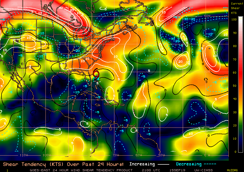
2019 Indicators: SST'S / Sal / MSLP / Steering / Shear / Instability (See updated graphics at first post)

This is the general tropical discussion area. Anyone can take their shot at predicting a storms path.

Moderator: S2k Moderators

Forum rules

The posts in this forum are NOT official forecasts and should not be used as such. They are just the opinion of the poster and may or may not be backed by sound meteorological data. They are NOT endorsed by any professional institution or STORM2K. For official information, please refer to products from the National Hurricane Center and National Weather Service.

Help Support Storm2K
Message
Author
User avatar
Hammy
Category 5
Category 5
Posts: 5594
Age: 40
Joined: Fri May 25, 2012 5:25 pm
Contact:

Re: 2019 Indicators: SST'S / Sal / MSLP / Steering / Shear / Instability (See updated graphics at first post)

#1281 Postby Hammy » Sun Sep 15, 2019 2:09 pm

SFLcane wrote:I asked ventrice on Twitter on why there’s isn’t much on the models despite mjo moving and a strong kelvin wave and this was his response below..

models will miss the convective enhancement to pre-existing waves and will struggle with the convective triggering of news waves over Africa.


Are they essentially behaving as if the current base state will continue even if it's about to change? Because I noticed as the more favorable conditions were about to exit earlier, the models continued a high level of activity well beyond that.
1 likes   
The above post is not official and should not be used as such. It is the opinion of the poster and may or may not be backed by sound meteorological data. It is not endorsed by any professional institution or storm2k.org. For official information, please refer to the NHC and NWS products.

User avatar
SFLcane
S2K Supporter
S2K Supporter
Posts: 9618
Age: 46
Joined: Sat Jun 05, 2010 1:44 pm
Location: Lake Worth Florida

Re: 2019 Indicators: SST'S / Sal / MSLP / Steering / Shear / Instability (See updated graphics at first post)

#1282 Postby SFLcane » Sun Sep 15, 2019 6:55 pm

I think it’s only a matter of time strong mjo pulse coupled with a powerful kelvin wave activity will start showing up on the models. Quite concerned about the Caribbean if anything gets going it could get pulled north with all this trofiness in place as of late. Could get real busy soon!

Image
2 likes   

User avatar
cycloneye
Admin
Admin
Posts: 139406
Age: 67
Joined: Thu Oct 10, 2002 10:54 am
Location: San Juan, Puerto Rico

Re: 2019 Indicators: SST'S / Sal / MSLP / Steering / Shear / Instability (See updated graphics at first post)

#1283 Postby cycloneye » Sun Sep 15, 2019 6:57 pm

:uarrow: SFLcane,already GFS and Euro are sniffing long range stuff.
1 likes   
Visit the Caribbean-Central America Weather Thread where you can find at first post web cams,radars
and observations from Caribbean basin members Click Here

psyclone
S2K Supporter
S2K Supporter
Posts: 4495
Joined: Wed Aug 24, 2005 9:04 pm
Location: palm harbor fl

Re: 2019 Indicators: SST'S / Sal / MSLP / Steering / Shear / Instability (See updated graphics at first post)

#1284 Postby psyclone » Sun Sep 15, 2019 7:25 pm

We are setting the stage for October to do make up work for August. I've long been concerned about a late season NW Caribbean whopper. We had similar warning pings weeks in advance of Michael last year.. The coming favorable conditions add a tailwind to an already dicey climo for the region.
3 likes   

User avatar
Hurricaneman
Category 5
Category 5
Posts: 7284
Age: 43
Joined: Tue Aug 31, 2004 3:24 pm
Location: central florida

Re: 2019 Indicators: SST'S / Sal / MSLP / Steering / Shear / Instability (See updated graphics at first post)

#1285 Postby Hurricaneman » Sun Sep 15, 2019 8:23 pm

By mid week the models may really start to catch on to these conditions but right now it seems the models may be starting to see these conditions but not fully yet
0 likes   

User avatar
gatorcane
S2K Supporter
S2K Supporter
Posts: 23499
Age: 46
Joined: Sun Mar 13, 2005 3:54 pm
Location: Boca Raton, FL

Re: 2019 Indicators: SST'S / Sal / MSLP / Steering / Shear / Instability (See updated graphics at first post)

#1286 Postby gatorcane » Sun Sep 15, 2019 8:32 pm

I agree with all of you about the Western Caribbean. Think we may get as least one significant hurricane and possibly multiple systems as we head later into this month and October and even November. By the way conditions have been very favorable across the Caribbean the past couple of weeks just no waves are making it to the Western Caribbean yet. For example:

Image
3 likes   

User avatar
captainbarbossa19
Category 5
Category 5
Posts: 1040
Joined: Wed Aug 21, 2019 11:09 pm
Location: Starkville, MS

Re: 2019 Indicators: SST'S / Sal / MSLP / Steering / Shear / Instability (See updated graphics at first post)

#1287 Postby captainbarbossa19 » Sun Sep 15, 2019 9:56 pm

Image

As of right now, there is still plenty of energy available for tropical systems to use in the Western Caribbean and the Gulf of Mexico. If a wave enters this area and conditions are favorable, it could easily develop into a strong hurricane. I do not think that the season is over for this region yet. Many systems have formed in past Octobers in this region. Also, it is interesting that the Eastern Caribbean seems to be quite warm now as well.
2 likes   


User avatar
Hurricaneman
Category 5
Category 5
Posts: 7284
Age: 43
Joined: Tue Aug 31, 2004 3:24 pm
Location: central florida

Re: 2019 Indicators: SST'S / Sal / MSLP / Steering / Shear / Instability (See updated graphics at first post)

#1289 Postby Hurricaneman » Mon Sep 16, 2019 12:08 am

The MDR may get shut down by this trade wind surge but that just means if something develops it will be in the Caribbean and there’s no way out of a landfall once that happens so this trade surge may end up being bad in the long run if you don’t like landfalling hurricanes
2 likes   

User avatar
StruThiO
Category 3
Category 3
Posts: 821
Age: 24
Joined: Fri Sep 15, 2017 5:51 am
Location: Currently Portland, OR. Raised in Jax, FL.

Re: 2019 Indicators: SST'S / Sal / MSLP / Steering / Shear / Instability (See updated graphics at first post)

#1290 Postby StruThiO » Mon Sep 16, 2019 2:35 am

Here's where we stand right now.

Image

Image
3 likes   

User avatar
SFLcane
S2K Supporter
S2K Supporter
Posts: 9618
Age: 46
Joined: Sat Jun 05, 2010 1:44 pm
Location: Lake Worth Florida

Re: 2019 Indicators: SST'S / Sal / MSLP / Steering / Shear / Instability (See updated graphics at first post)

#1291 Postby SFLcane » Mon Sep 16, 2019 8:23 am

Boom! That's about as favorable an Atlantic look as you can get now just waiting for the models to pick up on this

 https://twitter.com/MJVentrice/status/1173587374372208640


0 likes   

User avatar
CyclonicFury
Category 5
Category 5
Posts: 1976
Age: 25
Joined: Sun Jul 02, 2017 12:32 pm
Location: NC
Contact:

Re: 2019 Indicators: SST'S / Sal / MSLP / Steering / Shear / Instability (See updated graphics at first post)

#1292 Postby CyclonicFury » Mon Sep 16, 2019 11:01 am

StruThiO wrote:Here's where we stand right now.

https://i.imgur.com/VoZutkd.png

https://i.imgur.com/Bfz2gMu.png

Fairly close to average in most metrics. Activity should finish at least near normal, but in order to reach above normal, we would need a very active back half of the season. Late September into October appears favorable so I think 100+ ACE is still a distinct possibility.
3 likes   
NCSU B.S. in Meteorology Class of 2021. Tropical weather blogger at http://www.cyclonicfury.com. My forecasts and thoughts are NOT official, for official forecasts please consult the National Hurricane Center.

WeatherEmperor
S2K Supporter
S2K Supporter
Posts: 4806
Age: 40
Joined: Thu Sep 04, 2003 2:54 pm
Location: South Florida

Re: 2019 Indicators: SST'S / Sal / MSLP / Steering / Shear / Instability (See updated graphics at first post)

#1293 Postby WeatherEmperor » Mon Sep 16, 2019 11:22 am

So here is something that may or may not throw a monkey wrench into the favorable conditions in the Caribbean for October. Despite Nino 3.4 currently sitting at -0.3C the CFS and Euro show the region rapidly warming to near +0.5C during the month of October. While this appears unlikely it could happen because the SOI is still el nino’ish negative. Does anybody have any maps to see if WWB’s are on the horizon to support Nino 3.4 warming like this?

What do you guys think? No big deal or something to watch as it could make October conditions in the Caribbean less favorable than we think? Maybe the CFS and Euro are messed up and just dead wrong??

Image

Image


Sent from my iPhone using Tapatalk
1 likes   

User avatar
SFLcane
S2K Supporter
S2K Supporter
Posts: 9618
Age: 46
Joined: Sat Jun 05, 2010 1:44 pm
Location: Lake Worth Florida

Re: 2019 Indicators: SST'S / Sal / MSLP / Steering / Shear / Instability (See updated graphics at first post)

#1294 Postby SFLcane » Mon Sep 16, 2019 11:23 am

2 likes   

User avatar
CyclonicFury
Category 5
Category 5
Posts: 1976
Age: 25
Joined: Sun Jul 02, 2017 12:32 pm
Location: NC
Contact:

Re: 2019 Indicators: SST'S / Sal / MSLP / Steering / Shear / Instability (See updated graphics at first post)

#1295 Postby CyclonicFury » Mon Sep 16, 2019 12:49 pm

WeatherEmperor wrote:So here is something that may or may not throw a monkey wrench into the favorable conditions in the Caribbean for October. Despite Nino 3.4 currently sitting at -0.3C the CFS and Euro show the region rapidly warming to near +0.5C during the month of October. While this appears unlikely it could happen because the SOI is still el nino’ish negative. Does anybody have any maps to see if WWB’s are on the horizon to support Nino 3.4 warming like this?

What do you guys think? No big deal or something to watch as it could make October conditions in the Caribbean less favorable than we think? Maybe the CFS and Euro are messed up and just dead wrong??

https://uploads.tapatalk-cdn.com/20190916/e70e93ca9a5dfec62a69dc28f27e1168.gif

https://uploads.tapatalk-cdn.com/20190916/f1950393d53ccf213adbefa5e70dbe8a.png


Sent from my iPhone using Tapatalk

I'm not really buying that rapid shift back to El Nino conditions. We'll probably see some slight warming, possibly into the warm neutral range, but it shouldn't have a major effect on Caribbean shear. ECMWF has been predicting an El Nino essentially constantly for the past 5 years aside from 2016, it's garbage. And then you have the CFS, which changes its forecast every few days it seems.
4 likes   
NCSU B.S. in Meteorology Class of 2021. Tropical weather blogger at http://www.cyclonicfury.com. My forecasts and thoughts are NOT official, for official forecasts please consult the National Hurricane Center.

User avatar
Hurricaneman
Category 5
Category 5
Posts: 7284
Age: 43
Joined: Tue Aug 31, 2004 3:24 pm
Location: central florida

Re: 2019 Indicators: SST'S / Sal / MSLP / Steering / Shear / Instability (See updated graphics at first post)

#1296 Postby Hurricaneman » Mon Sep 16, 2019 5:07 pm

The end of the 12zGFS run did show what seems to be something trying to form from the monsoon gyre, seems to have caught on to the MJO and if it went farther out would be genesis so I believe the first week of October will have something form in the western Caribbean given the upcoming pattern
0 likes   

User avatar
DestinHurricane
Category 4
Category 4
Posts: 930
Joined: Tue May 01, 2018 8:05 am
Location: Columbus, OH... need to get back in the action

Re: 2019 Indicators: SST'S / Sal / MSLP / Steering / Shear / Instability (See updated graphics at first post)

#1297 Postby DestinHurricane » Mon Sep 16, 2019 6:22 pm

Here in the panhandle, we really dont want to hear about central american gyres in october right now...
0 likes   
Destin/Santa Rosa Beach, Florida: Ivan 2004, Dennis 2005, Michael 2018, Sally 2020

Fort Lauderdale, Florida Eta 2020, Many future storms!

THE Ohio State University: :cold:

WxEp
Tropical Depression
Tropical Depression
Posts: 69
Joined: Sat Sep 14, 2019 2:34 pm

Re: 2019 Indicators: SST'S / Sal / MSLP / Steering / Shear / Instability (See updated graphics at first post)

#1298 Postby WxEp » Mon Sep 16, 2019 8:00 pm

Hurricaneman wrote:The end of the 12zGFS run did show what seems to be something trying to form from the monsoon gyre, seems to have caught on to the MJO and if it went farther out would be genesis so I believe the first week of October will have something form in the western Caribbean given the upcoming pattern


Not much on the 18z GFS. A small bit of vorticity in the area. I believe the Legacy GFS showed something similar last year in October. The timeline kept getting pushed back but eventually something (unfortunately something big) did come from it. We'll have to see if the GFS shows something on future runs and if the time frame moves back as we've seen models do with the start of many potential TC's before.
0 likes   
The posts in this forum are NOT official forecast and should not be used as such. They are just the opinion of the poster and may or may not be backed by sound meteorological data. They are NOT endorsed by any professional institution or STORM2K. For official information, refer to products from the National Hurricane Center and National Weather Service.

User avatar
SFLcane
S2K Supporter
S2K Supporter
Posts: 9618
Age: 46
Joined: Sat Jun 05, 2010 1:44 pm
Location: Lake Worth Florida

Re: 2019 Indicators: SST'S / Sal / MSLP / Steering / Shear / Instability (See updated graphics at first post)

#1299 Postby SFLcane » Tue Sep 17, 2019 7:08 am

Looks like there is some US ridging but W ATL weakness. This pattern though can flirt with trouble, if something gets far enough west to get under the CONUS ridge.
0 likes   


Return to “Talkin' Tropics”

Who is online

Users browsing this forum: Bing [Bot], cajungal, HurricaneBelle, Hybridstorm_November2001, KirbyDude25, Lizzytiz1, NotSparta, SFLcane, TheAustinMan and 41 guests