Image Request Thread

This is the general tropical discussion area. Anyone can take their shot at predicting a storms path.

Moderator: S2k Moderators

Forum rules

The posts in this forum are NOT official forecasts and should not be used as such. They are just the opinion of the poster and may or may not be backed by sound meteorological data. They are NOT endorsed by any professional institution or STORM2K. For official information, please refer to products from the National Hurricane Center and National Weather Service.

Help Support Storm2K
Message
Author
HurricaneHunter914
Category 5
Category 5
Posts: 4439
Age: 31
Joined: Fri Mar 10, 2006 7:36 pm
Location: College Station, TX

#121 Postby HurricaneHunter914 » Wed Apr 12, 2006 3:09 pm

I've never seen that picture before. Pretty cool. How about Hurricane Betty
0 likes   

CHRISTY

#122 Postby CHRISTY » Wed Apr 12, 2006 3:16 pm

Hurricane Hunter 914 wrote:I've never seen that picture before. Pretty cool. How about Hurricane Betty
well i dont have a pic of betty but i managed to get this info of the web....

Hurricane Betty
(August 22 to September 1, 1972)
The first evidence of the disturbance that was to develop into Hurricane Betty appeared on August 21, 1972 in an area located about 460 kilometres north-northwest of Bermuda. The disturbance was designated Subtropical Storm Bravo on August 23 as ship reports suggested winds had reached gale force. Bravo continued eastward with little change in intensity during the next 24 hours. By the morning of the 25th, however, reports indicated that a warm core system was in progress. Unfavourable northwest winds over Bravo delayed further intensification until late on the 26th when acceleration and intensification took place. On the morning of the 27th, Subtropical Storm Bravo became Hurricane Betty in the north central Atlantic about 1480 kilometres west of the Azores. Records indicate that this is the highest latitude at which a storm ever first became a hurricane. Betty began to weaken and as pressures built to the east of the centre, deceleration took place. By the morning of the 30th, Betty turned to the west, after coming close to the island of Corvo in the Azores. Later that day, winds dropped below hurricane force, and by late on the 31st they were barely of tropical storm strength. The storm accelerated northward and became extratropical about 925 kilometres northwest of Corvo on the morning of September 1.
0 likes   

User avatar
JtSmarts
S2K Supporter
S2K Supporter
Posts: 1437
Age: 39
Joined: Thu Jul 10, 2003 1:29 pm
Location: Columbia, South Carolina

#123 Postby JtSmarts » Wed Apr 12, 2006 4:32 pm

Thanks Christy for the pics of Bonnie and Bertha. :ggreen: :cheesy:
0 likes   

User avatar
JtSmarts
S2K Supporter
S2K Supporter
Posts: 1437
Age: 39
Joined: Thu Jul 10, 2003 1:29 pm
Location: Columbia, South Carolina

#124 Postby JtSmarts » Wed Apr 12, 2006 4:42 pm

How about Emily (1993) as it passed by NC, Hurricane Erin (1995) as it hit FL?
0 likes   

CHRISTY

#125 Postby CHRISTY » Wed Apr 12, 2006 5:08 pm

JtSmarts wrote:How about Emily (1993) as it passed by NC, Hurricane Erin (1995) as it hit FL?
here's a couple of EMILY...

Image


Image

Image


here's hurricane ERIN....

Image

Image

Image

Image

Image
0 likes   

User avatar
ck30322
Tropical Wave
Tropical Wave
Posts: 8
Joined: Sat Sep 11, 2004 5:17 pm
Contact:

#126 Postby ck30322 » Wed Apr 12, 2006 7:46 pm

Hurricane Hunter 914 wrote:I've never seen that picture before. Pretty cool. How about Hurricane Betty


Go to the NHC website,
There's a satellite pic of Betty (as growing subtropical storm Bravo) on page 4 of the hurricane Agnes report.
0 likes   

Matt-hurricanewatcher

#127 Postby Matt-hurricanewatcher » Wed Apr 12, 2006 8:59 pm

In we will be able to add some pics of Emily in 2011.
0 likes   

User avatar
JtSmarts
S2K Supporter
S2K Supporter
Posts: 1437
Age: 39
Joined: Thu Jul 10, 2003 1:29 pm
Location: Columbia, South Carolina

#128 Postby JtSmarts » Wed Apr 12, 2006 10:21 pm

Christy you are the hurricane GURU, thanks again!!
0 likes   

CHRISTY

#129 Postby CHRISTY » Wed Apr 12, 2006 10:25 pm

JtSmarts wrote:Christy you are the hurricane GURU, thanks again!!
what! :blow:
0 likes   

CHRISTY

#130 Postby CHRISTY » Wed Apr 12, 2006 11:08 pm

The lowest estimated central pressure was 872 mb. The eye circulation extended up to 55,000 feet. The maximum sustained winds were estimated at at least 180mph at its peak.also was a monster like TIP.

Image
0 likes   

User avatar
HalloweenGale
Category 1
Category 1
Posts: 377
Joined: Sun Aug 01, 2004 7:31 pm
Location: Nantucket Ma
Contact:

#131 Postby HalloweenGale » Thu Apr 13, 2006 7:29 am

How about the following:

Ana(1997)
Frances(1998)
Hermine(1998)
Georges(as a dying tropical depression)(1998)
Mitch, as an extratropical system
Floyd(1993)
Harvey(1993)
Katrina(1981)
Floyd(1987)
Arlene(1987)
Michael(2000)


I'll have more later....
0 likes   

CHRISTY

#132 Postby CHRISTY » Thu Apr 13, 2006 2:28 pm

HalloweenGale wrote:How about the following:

Ana(1997)
Frances(1998)
Hermine(1998)
Georges(as a dying tropical depression)(1998)
Mitch, as an extratropical system
Floyd(1993)
Harvey(1993)
Katrina(1981)
Floyd(1987)
Arlene(1987)
Michael(2000)


I'll have more later....


HERE'S ANA.

Image

HERE'S FRANCES AS A TROPICAL STORM IN 1998.

Image

HERE'S HERMINE ALSO AS A TROPICAL STORM..

Image

DONT HAVE OF GEORGES AS A TD BUT I HAVE OTHERS HERE YA GO..

Image

Image

Image

Image
I DECIDED TO ADD THIS ONE CAUSE I THOUGHT IT WAS COOL...4 NAMED STORMS AT THE SAME TIME IN 1998!


Image

ONLY MITCH I HAVE IS THIS ONE WHICH IS ACTUALLY ONE OF MY FAVORITES...

Image

Image

Image

Image

NO IMAGES OF FLOYD IN 1993...BUT I GOT PICS OF FLOYD IN 1999..

Image

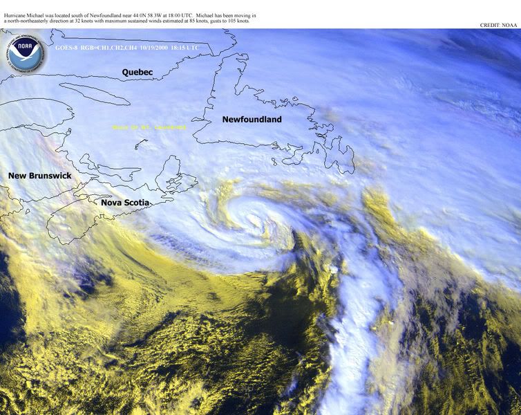
HURRICANE MICHEAL IN 2000...

Image

ASK ME FOR MORE RECENT HURRICANES U ARE GOING TO FAR BACK...
0 likes   

User avatar
Hyperstorm
Category 5
Category 5
Posts: 1500
Joined: Sun Sep 07, 2003 3:48 am
Location: Ocala, FL

#133 Postby Hyperstorm » Thu Apr 13, 2006 6:36 pm

If you want to see a satellite image of Atlantic named storms since 1977, go to Wikipedia Encyclopedia. Here's the link for Atlantic Hurricane Seasons:

http://en.wikipedia.org/wiki/List_of_At ... ne_seasons
0 likes   

Jim Cantore

#134 Postby Jim Cantore » Thu Apr 13, 2006 6:47 pm

HalloweenGale wrote:How about the following:

Ana(1997)
Frances(1998)
Hermine(1998)
Georges(as a dying tropical depression)(1998)
Mitch, as an extratropical system
Floyd(1993)
Harvey(1993)
Katrina(1981)
Floyd(1987)
Arlene(1987)
Michael(2000)


I'll have more later....


Floyd 1987
Image
Arlene 1987
Image
Mitch Extratropical
Image
Dying Georges
Image
Harvey 1993
Image
Katrina 1981
Image
Ana 1997
Image
Frances 1998
Image
Hermine 1998
Image
Michael 2000
Image
0 likes   

User avatar
HalloweenGale
Category 1
Category 1
Posts: 377
Joined: Sun Aug 01, 2004 7:31 pm
Location: Nantucket Ma
Contact:

#135 Postby HalloweenGale » Fri Apr 14, 2006 9:03 am

I have more:

Bill(1997)
Juan(2003)
Gabrielle as it hit Newfoundland(2001)
Nicole(1998)
Nana(1990)


more later....
0 likes   

Jim Cantore

#136 Postby Jim Cantore » Fri Apr 14, 2006 9:46 am

HalloweenGale wrote:I have more:

Bill(1997)
Juan(2003)
Gabrielle as it hit Newfoundland(2001)
Nicole(1998)
Nana(1990)


more later....


NanaImage
BillImage
Gabrielle hitting newfoundland Image
Juan Image
Nicole Image
0 likes   

CHRISTY

#137 Postby CHRISTY » Fri Apr 14, 2006 9:53 am

BILL...

Image

JUAN 2003..

Image


Gabrielle
Image

nicole..

Image

dont have nana....
0 likes   

User avatar
HalloweenGale
Category 1
Category 1
Posts: 377
Joined: Sun Aug 01, 2004 7:31 pm
Location: Nantucket Ma
Contact:

#138 Postby HalloweenGale » Fri Apr 14, 2006 11:16 am

Karen(2001)
Gustav(2002)
Floyd as an Extratropical Remnant(1999)
Frances(1992)
Gert merging with Floyd(1999)
Edouard(2002)
Henri(1985)
0 likes   

CHRISTY

#139 Postby CHRISTY » Fri Apr 14, 2006 5:52 pm

HalloweenGale wrote:Karen(2001)
Gustav(2002)
Floyd as an Extratropical Remnant(1999)
Frances(1992)
Gert merging with Floyd(1999)
Edouard(2002)
Henri(1985)


hurricane karen..

Image

hurricane gustav...

Image

hurricane frances in 1992


Image
0 likes   

User avatar
wxmann_91
Category 5
Category 5
Posts: 8013
Age: 34
Joined: Fri Jul 15, 2005 2:49 pm
Location: Southern California
Contact:

#140 Postby wxmann_91 » Fri Apr 14, 2006 6:05 pm

It's almost impossible to browse through this thread, there are so many pictures that take so long to load (and I have broadband). How about linking those pics rather than directly posting them?
0 likes   


Return to “Talkin' Tropics”

Who is online

Users browsing this forum: Cpv17, Google [Bot], Heretoserve, Tak5, wileytheartist and 78 guests