Potential development over the Western Caribbean Sea (Is Invest 99L)
Moderator: S2k Moderators
Forum rules

The posts in this forum are NOT official forecasts and should not be used as such. They are just the opinion of the poster and may or may not be backed by sound meteorological data. They are NOT endorsed by any professional institution or STORM2K. For official information, please refer to products from the National Hurricane Center and National Weather Service.

Re: Potential development over the Western Caribbean Sea (40/80)
2024 is really trying to contend for costliest hurricane season on record. 
4 likes
Igor 2010, Sandy 2012, Fay 2014, Gonzalo 2014, Joaquin 2015, Nicole 2016, Humberto 2019, Imelda 2025
I am only a tropical weather enthusiast. My predictions are not official and may or may not be backed by sound meteorological data. For official information, please refer to the NHC and NWS products.
I am only a tropical weather enthusiast. My predictions are not official and may or may not be backed by sound meteorological data. For official information, please refer to the NHC and NWS products.
-
Weatherboy1

- Category 5

- Posts: 1190
- Age: 50
- Joined: Mon Jul 05, 2004 1:50 pm
- Location: Jupiter/Sarasota, FL
Re: Potential development over the Western Caribbean Sea (40/80)
Am I really here in mid-November...talking about a possible mid-to-high-end hurricane hitting Florida from the SW? Or is this like a Twilight Zone episode? LOL. But in all seriousness, model trends definitely concerning. Here in Sarasota they still have piles of yard waste everywhere from Milton. Not to mention the occasional sailboat sitting on a sidewalk/beach. Sheesh...
1 likes

Re: Potential development over the Western Caribbean Sea (40/80)
06z Euro stalls much closer to the coast of Central America than the 00z run. Just a few dozen miles to the west and it would’ve made landfall.
It’s probably going to be a very close call between the Nadine 2.0 and meandering major scenarios. Very small changes in future Sara’s track will make a world of a difference.
It’s probably going to be a very close call between the Nadine 2.0 and meandering major scenarios. Very small changes in future Sara’s track will make a world of a difference.
3 likes
Irene '11 Sandy '12 Hermine '16 5/15/2018 Derecho Fay '20 Isaias '20 Elsa '21 Henri '21 Ida '21
I am only a meteorology enthusiast who knows a decent amount about tropical cyclones. Look to the professional mets, the NHC, or your local weather office for the best information.
I am only a meteorology enthusiast who knows a decent amount about tropical cyclones. Look to the professional mets, the NHC, or your local weather office for the best information.
-
TomballEd
- Category 5
- Posts: 1315
- Age: 62
- Joined: Wed Aug 16, 2023 4:52 pm
- Location: Spring/Klein area, not Tomball
Re: Potential development over the Western Caribbean Sea (40/80)
Kazmit wrote:2024 is really trying to contend for costliest hurricane season on record.
Just when you think you are out, they pull you back in!
1 likes
-
jlauderdal
- S2K Supporter

- Posts: 7240
- Joined: Wed May 19, 2004 5:46 am
- Location: NE Fort Lauderdale
- Contact:
Re: Potential development over the Western Caribbean Sea (40/80)
chris_fit wrote:Hopefully Wxman57 has not signed off for the season yet. Curious on his thoughts.
He will be taking comp days this week...
0 likes
-
jlauderdal
- S2K Supporter
- Posts: 7240
- Joined: Wed May 19, 2004 5:46 am
- Location: NE Fort Lauderdale
- Contact:
Re: Potential development over the Western Caribbean Sea (40/80)
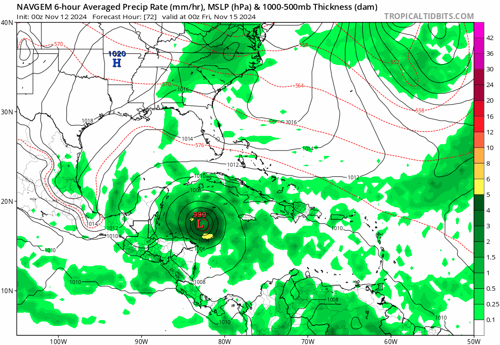
Deep trough from the west with a deep low coming in from the south, major energy being shed in the gulf, you can see the storm getting elongated at the end of the run as the trough crushes it
1 likes
-
TheDreamTraveler

- Category 2

- Posts: 645
- Joined: Sun Aug 22, 2010 3:10 am
- Location: PA
Re: Potential development over the Western Caribbean Sea (40/80)
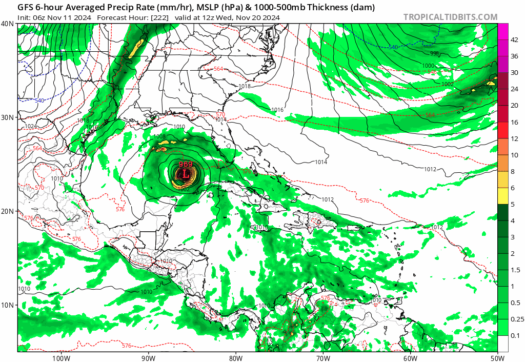
Missed the model runs the past day or so and just caught up. Very concerning. Would be wild to have a third major hitting Florida and in the middle of November on top of that. Extremely rare. This season has been all about breaking records. 2024 would be outperforming 2020 in intensity if this happens. We did have 2 majors in November 2020 but those both ran west into Central America so seeing one get into the gulf as a major and striking Florida would be wild.
0 likes
-
SFLcane

- S2K Supporter
- Posts: 10281
- Age: 48
- Joined: Sat Jun 05, 2010 1:44 pm
- Location: Lake Worth Florida
Re: Potential development over the Western Caribbean Sea (40/80)
jlauderdal wrote:
Deep trough from the west with a deep low coming in from the south, major energy being shed in the gulf, you can see the storm getting elongated at the end of the run as the trough crushes it
If this pulls a wilma and avoids CA the enviroment looks great for rapid intensification we could be certainly looking at a Cat 4 in the nw Caribbean with only slight weakening on approach to FL if it indeed does that.
0 likes
Re: Potential development over the Western Caribbean Sea (40/80)
gatorcane wrote:GFS trend last 5 runs:
https://i.postimg.cc/DZrK6fgb/gfs-mslp-pcpn-watl-fh198-trend.gif
Well, that's concerning.
0 likes
Cleo - 1964, Betsy - 1965, David - 1979, Andrew - 1992, Charlie (Francis, Ivan, Jeanne) - 2004, Irma - 2017, Ian - 2022, Milton - 2024
Re: Potential development over the Western Caribbean Sea (40/80)
And I was just thinking today that I could take down the hurricane shutters!!
0 likes
Cleo - 1964, Betsy - 1965, David - 1979, Andrew - 1992, Charlie (Francis, Ivan, Jeanne) - 2004, Irma - 2017, Ian - 2022, Milton - 2024
-
gatorcane

- S2K Supporter
- Posts: 23708
- Age: 48
- Joined: Sun Mar 13, 2005 3:54 pm
- Location: Boca Raton, FL
Re: Potential development over the Western Caribbean Sea (40/80)
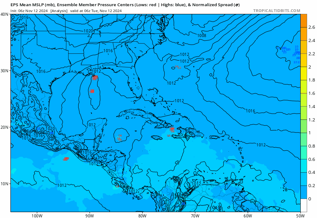
Really bullish Euro ensembles
0 likes
-
cycloneye

- Admin

- Posts: 149667
- Age: 69
- Joined: Thu Oct 10, 2002 10:54 am
- Location: San Juan, Puerto Rico
Re: Potential development over the Western Caribbean Sea (40/80)
0 likes
Visit the Caribbean-Central America Weather Thread where you can find at first post web cams,radars
and observations from Caribbean basin members Click Here
and observations from Caribbean basin members Click Here
Re: Potential development over the Western Caribbean Sea (40/80)
GFS keeps trending stronger in near term intensity. 12z run has a TS by Thursday.
0 likes

Re: Potential development over the Western Caribbean Sea (40/80)
12z ICON further SW, TS into Belize as it pulls north.
0 likes

Re: Potential development over the Western Caribbean Sea (40/80)
Think I'll tie my hopes to the ICON's recent success track forecast success and root for it's 12Z solution  It's 12Z has it dragging the system through CA and Yucatan, with only an eventual TD up near N Fla.
0 likes
Andy D
(For official information, please refer to the NHC and NWS products.)
(For official information, please refer to the NHC and NWS products.)
-
SFLcane
- S2K Supporter
- Posts: 10281
- Age: 48
- Joined: Sat Jun 05, 2010 1:44 pm
- Location: Lake Worth Florida
Re: Potential development over the Western Caribbean Sea (40/80)
kevin wrote:12z ICON further SW, TS into Belize as it pulls north.
If icon was only worth anything lol...
0 likes
Re: Potential development over the Western Caribbean Sea (40/80)
12z GFS with a TD/TS in as little as 36-48 hours, once again missed Central America and stalls out in the WCar.
0 likes
Irene '11 Sandy '12 Hermine '16 5/15/2018 Derecho Fay '20 Isaias '20 Elsa '21 Henri '21 Ida '21
I am only a meteorology enthusiast who knows a decent amount about tropical cyclones. Look to the professional mets, the NHC, or your local weather office for the best information.
I am only a meteorology enthusiast who knows a decent amount about tropical cyclones. Look to the professional mets, the NHC, or your local weather office for the best information.
-
chris_fit

- Category 5
- Posts: 3261
- Age: 43
- Joined: Wed Sep 10, 2003 11:58 pm
- Location: Tampa Bay Area, FL
Re: Potential development over the Western Caribbean Sea (40/80)
SFLcane wrote:kevin wrote:12z ICON further SW, TS into Belize as it pulls north.
If icon was only worth anything lol...
It is. One of the best models this season. Several big wins.
0 likes
Re: Potential development over the Western Caribbean Sea (40/80)
SFLcane wrote:kevin wrote:12z ICON further SW, TS into Belize as it pulls north.
If icon was only worth anything lol...
It did perform pretty well with several Gulf systems this year, so I wouldn’t count it out.
0 likes
Irene '11 Sandy '12 Hermine '16 5/15/2018 Derecho Fay '20 Isaias '20 Elsa '21 Henri '21 Ida '21
I am only a meteorology enthusiast who knows a decent amount about tropical cyclones. Look to the professional mets, the NHC, or your local weather office for the best information.
I am only a meteorology enthusiast who knows a decent amount about tropical cyclones. Look to the professional mets, the NHC, or your local weather office for the best information.
-
SFLcane
- S2K Supporter
- Posts: 10281
- Age: 48
- Joined: Sat Jun 05, 2010 1:44 pm
- Location: Lake Worth Florida
Re: Potential development over the Western Caribbean Sea (40/80)
chris_fit wrote:SFLcane wrote:kevin wrote:12z ICON further SW, TS into Belize as it pulls north.
If icon was only worth anything lol...
It is. One of the best models this season. Several big wins.
meh... i will stick with GEFS, EPS and the op's
0 likes
Who is online
Users browsing this forum: hurricanes1234 and 217 guests