Possible development in the Gulf of Mexico (Is Invest 92L)

This is the general tropical discussion area. Anyone can take their shot at predicting a storms path.

Moderator: S2k Moderators

Forum rules

The posts in this forum are NOT official forecasts and should not be used as such. They are just the opinion of the poster and may or may not be backed by sound meteorological data. They are NOT endorsed by any professional institution or STORM2K. For official information, please refer to products from the National Hurricane Center and National Weather Service.

Help Support Storm2K
Message
Author
User avatar
cheezyWXguy
Category 5
Category 5
Posts: 6108
Joined: Mon Feb 13, 2006 12:29 am
Location: Dallas, TX

Re: Possible development in the Western Caribbean (0/40)

#121 Postby cheezyWXguy » Sat Sep 28, 2024 11:54 am

WeatherBoy2000 wrote:
ConvergenceZone wrote:Wxman, I agree with ya. Fronts seem to be aggressive this late season. I think that anything that forms the rest of this season will probably be on the weak side. We are getting to the time of year where fronts get stronger and the gulf turns unfavorable like you mentioned. Other than this weak storm possible in the gulf that you mentioned, anything strong that forms will probably be pulled out to sea due to more fronts coming down and weaknesses developing. We are seeing that already with storms forming in the Atlantic. I'm fine with this though. It's already been a horrible year for folks with landfalling hurricanes.


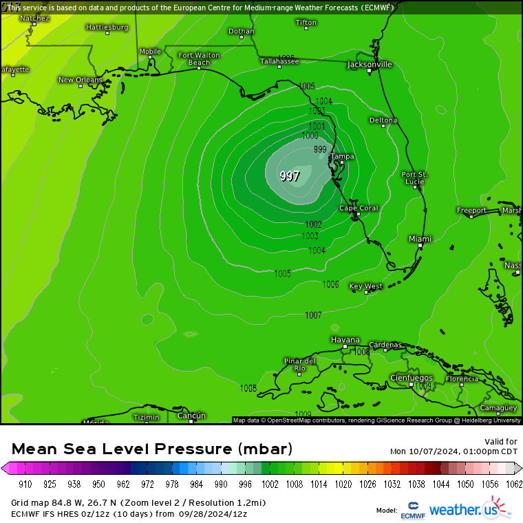
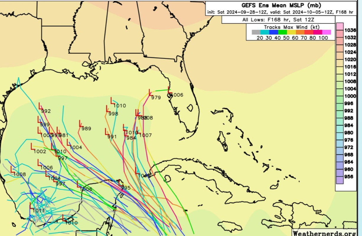
We still have all of October to get through which is still prime time for gulf majors of this variety. Just because conditions might be unfavorable for this AOI doesn't mean they'll be unfavorable for something else later in the month.

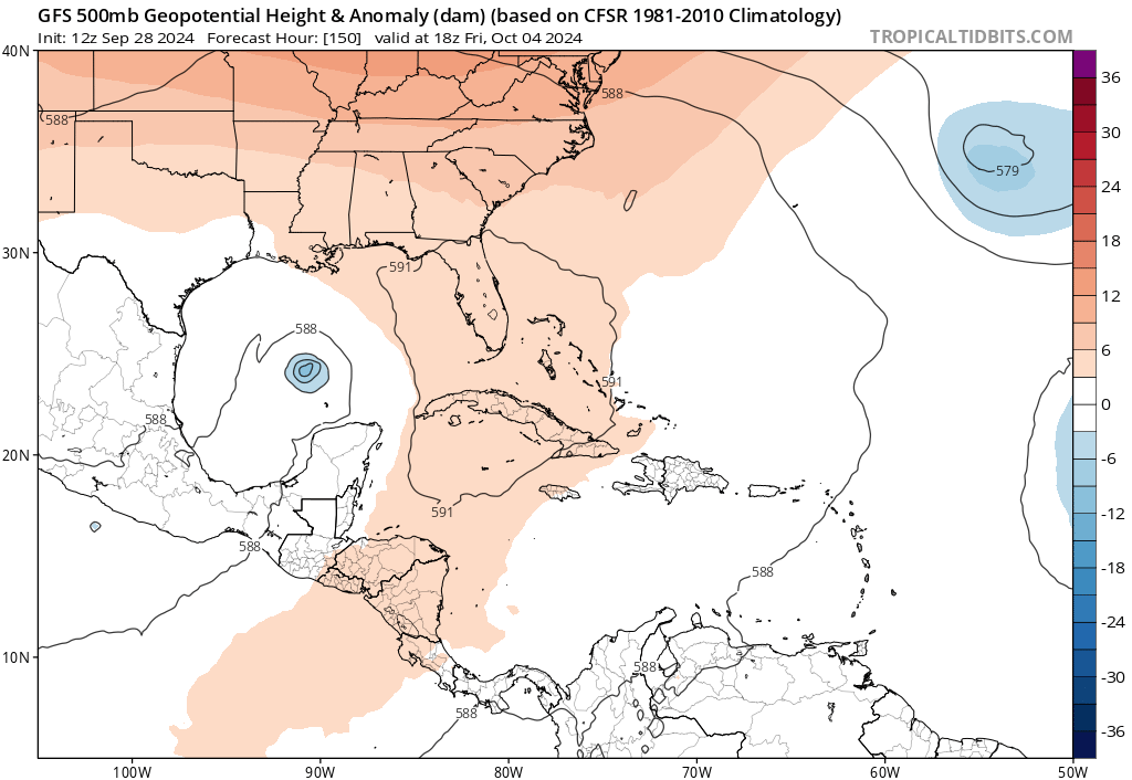
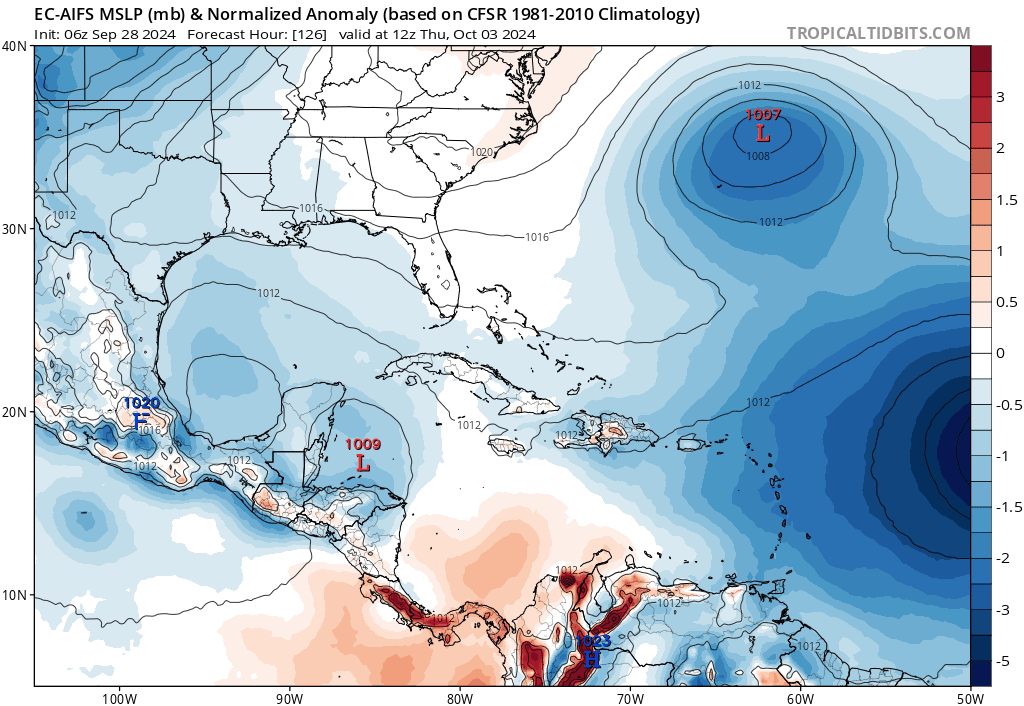
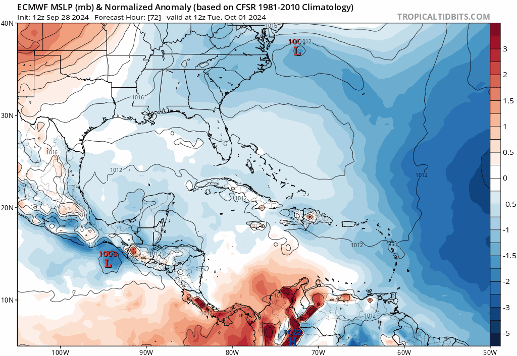
I think a variable that will impact this storm’s potential peak intensity also is how far north or west in the gom it actually gets. More so in either or both directions would lead to a less favorable interaction with the approaching trough, while a further south track that cuts east would probably enhance it. I believe Ian’s deviation south of initial projections is why Ian exceeded intensity expectations. While a track like that seems to be climatologically favored this time of year, I don’t see a lot of model support for it at this time though.
3 likes   

User avatar
SFLcane
S2K Supporter
S2K Supporter
Posts: 10163
Age: 47
Joined: Sat Jun 05, 2010 1:44 pm
Location: Lake Worth Florida

Re: Possible development in the Western Caribbean (0/40)

#122 Postby SFLcane » Sat Sep 28, 2024 11:54 am

:eek:

Image
3 likes   

User avatar
toad strangler
S2K Supporter
S2K Supporter
Posts: 4543
Joined: Sun Jul 28, 2013 3:09 pm
Location: Earth
Contact:

Re: Possible development in the Western Caribbean (0/40)

#123 Postby toad strangler » Sat Sep 28, 2024 11:57 am

ConvergenceZone wrote:Wxman, I agree with ya. Fronts seem to be aggressive this late season. I think that anything that forms the rest of this season will probably be on the weak side. We are getting to the time of year where fronts get stronger and the gulf turns unfavorable like you mentioned. Other than this weak storm possible in the gulf that you mentioned, anything strong that forms will probably be pulled out to sea due to more fronts coming down and weaknesses developing. We are seeing that already with storms forming in the Atlantic. I'm fine with this though. It's already been a horrible year for folks with landfalling hurricanes.


I don’t think 57 was saying anything about the rest of the season and especially on the E side of the Gulf. Just about this possible event, and even then he HOPES its weak as modeled.
0 likes   

User avatar
SFLcane
S2K Supporter
S2K Supporter
Posts: 10163
Age: 47
Joined: Sat Jun 05, 2010 1:44 pm
Location: Lake Worth Florida

Re: Possible development in the Western Caribbean (0/40)

#124 Postby SFLcane » Sat Sep 28, 2024 12:03 pm

Ridge protecting FL no turns towards the state on the gefs..

Image
0 likes   

User avatar
SFLcane
S2K Supporter
S2K Supporter
Posts: 10163
Age: 47
Joined: Sat Jun 05, 2010 1:44 pm
Location: Lake Worth Florida

Re: Possible development in the Western Caribbean (0/40)

#125 Postby SFLcane » Sat Sep 28, 2024 12:06 pm

SFLcane wrote:Ridge protecting FL no turns towards the state on the gefs..

https://i.postimg.cc/kG3LJS47/bbb.png


Image
0 likes   

User avatar
gatorcane
S2K Supporter
S2K Supporter
Posts: 23691
Age: 47
Joined: Sun Mar 13, 2005 3:54 pm
Location: Boca Raton, FL

Re: Possible development in the Western Caribbean (0/40)

#126 Postby gatorcane » Sat Sep 28, 2024 12:18 pm

SFLcane wrote:
SFLcane wrote:Ridge protecting FL no turns towards the state on the gefs..

https://i.postimg.cc/kG3LJS47/bbb.png


https://i.postimg.cc/YCR4QfKy/jjj.png

Timing is going to be key here. There is a recurving Typhoon in the WPAC which results in a deep trough that swings through the CONUS. You can see in the long-range GFS, it is trending faster and deeper with the trough. If this potential Western Caribbean system is slower to lift out, that ridge may not be protecting Florida:

Image
2 likes   

User avatar
Canelaw99
S2K Supporter
S2K Supporter
Posts: 2127
Age: 48
Joined: Tue Aug 31, 2004 8:27 am
Location: Homestead, FL

Re: Possible development in the Western Caribbean (0/40)

#127 Postby Canelaw99 » Sat Sep 28, 2024 12:25 pm

gatorcane wrote:MUCH stronger in the Gulf on the GFS. CMC is a bit stronger also. GFS shifts west and the CMC shifts east towards Florida


At this point, I, for one, will take the rain a storm brings if it means keeping it away from western NC and eastern TN.
2 likes   

User avatar
cycloneye
Admin
Admin
Posts: 145271
Age: 68
Joined: Thu Oct 10, 2002 10:54 am
Location: San Juan, Puerto Rico

Re: Possible development in the Western Caribbean (0/50)

#128 Postby cycloneye » Sat Sep 28, 2024 12:29 pm

Western Caribbean Sea and Gulf of Mexico:
An area of low pressure is expected to form over the western
Caribbean Sea in a couple of days. Environmental conditions are
forecast to be conducive for gradual development thereafter, and a
tropical depression could form around the middle part of next week.
This system is expected to move northwestward into the Gulf of
Mexico during the latter portion of next week, and interests in the
northwestern Caribbean Sea and along the U.S. Gulf Coast should
monitor its progress.
* Formation chance through 48 hours...low...near 0 percent.
* Formation chance through 7 days...medium...50 percent.


Image
0 likes   
Visit the Caribbean-Central America Weather Thread where you can find at first post web cams,radars
and observations from Caribbean basin members Click Here

jlauderdal
S2K Supporter
S2K Supporter
Posts: 7182
Joined: Wed May 19, 2004 5:46 am
Location: NE Fort Lauderdale
Contact:

Re: Possible development in the Western Caribbean (0/40)

#129 Postby jlauderdal » Sat Sep 28, 2024 12:30 pm

Canelaw99 wrote:
gatorcane wrote:MUCH stronger in the Gulf on the GFS. CMC is a bit stronger also. GFS shifts west and the CMC shifts east towards Florida


At this point, I, for one, will take the rain a storm brings if it means keeping it away from western NC and eastern TN.
I hear ya, we can absorb some pain in SE Florida, we have had plenty of good fortune.
2 likes   

User avatar
gatorcane
S2K Supporter
S2K Supporter
Posts: 23691
Age: 47
Joined: Sun Mar 13, 2005 3:54 pm
Location: Boca Raton, FL

Re: Possible development in the Western Caribbean (0/50)

#130 Postby gatorcane » Sat Sep 28, 2024 12:34 pm

06Z EC-AIFS has trended stronger but same track into Florida as the previous run. Not a good sign for Florida given the model has had an excellent track record this year in the long-range:

Image
Last edited by gatorcane on Sat Sep 28, 2024 12:37 pm, edited 1 time in total.
3 likes   

User avatar
tiger_deF
Category 1
Category 1
Posts: 468
Age: 24
Joined: Tue Sep 27, 2016 11:47 am

Re: Possible development in the Western Caribbean (0/50)

#131 Postby tiger_deF » Sat Sep 28, 2024 12:36 pm

Worth pointing out that the GFS has trackeable vorticity and cyclogenesis in 2-3 days. Considering that we were tracking the potential of Helene for over a week and a half, this one feels like it just snuck up on us.
3 likes   

User avatar
ThunderForce
Tropical Storm
Tropical Storm
Posts: 208
Age: 25
Joined: Tue Sep 27, 2022 6:20 pm
Location: Calhoun County, Florida

Re: Possible development in the Western Caribbean (0/50)

#132 Postby ThunderForce » Sat Sep 28, 2024 12:42 pm

The Gulf coast really needs a break, at least for a few weeks, from hurricanes. This is getting insane.

On that note I can't believe there is actually a possibility somewhere on the Gulf might get hit by another storm just a little over a week out from Helene's landfall. Those affected by Helene and Francine really need to be able to have time to recover. SIGH...
Last edited by ThunderForce on Sat Sep 28, 2024 12:49 pm, edited 2 times in total.
4 likes   
Please refer to the NWS, NHC, SPC or a professional meteorologist for information and decision making during storms.

Weathertracker96
Tropical Storm
Tropical Storm
Posts: 104
Joined: Mon Oct 16, 2023 3:41 pm

Re: Possible development in the Western Caribbean (0/40)

#133 Postby Weathertracker96 » Sat Sep 28, 2024 12:44 pm

gatorcane wrote:
SFLcane wrote:
SFLcane wrote:Ridge protecting FL no turns towards the state on the gefs..

https://i.postimg.cc/kG3LJS47/bbb.png


https://i.postimg.cc/YCR4QfKy/jjj.png

Timing is going to be key here. There is a recurving Typhoon in the WPAC which results in a deep trough that swings through the CONUS. You can see in the long-range GFS, it is trending faster and deeper with the trough. If this potential Western Caribbean system is slower to lift out, that ridge may not be protecting Florida:

https://i.postimg.cc/CLMB543K/gfs-z500a-Norm-us-fh222-trend.gif


I agree. It seems more GEFS members go into FL as the run progresses. Timing is going to be key.
0 likes   

User avatar
Teban54
Category 5
Category 5
Posts: 3204
Joined: Sat May 19, 2018 1:19 pm

Re: Possible development in the Western Caribbean (0/50)

#134 Postby Teban54 » Sat Sep 28, 2024 12:45 pm

tiger_deF wrote:Worth pointing out that the GFS has trackeable vorticity and cyclogenesis in 2-3 days. Considering that we were tracking the potential of Helene for over a week and a half, this one feels like it just snuck up on us.

To be fair, the signal first started showing up earlier in advance, but everyone was busy tracking Helene at that time.
3 likes   

User avatar
ColdMiser123
Professional-Met
Professional-Met
Posts: 904
Age: 29
Joined: Mon Sep 26, 2016 3:26 pm
Location: Northeast US

Re: Possible development in the Western Caribbean (0/50)

#135 Postby ColdMiser123 » Sat Sep 28, 2024 12:51 pm

Euro has a 996 mb TS going into Tampa Bay.

A tropical wave passing to the north of the gyre can sometimes spark development off of it, which is why modeling is more aggressive on development overall compared to what you'd see from a typical GFS phantom gyre storm.
2 likes   
B.S., M.S., Meteorology & Atmospheric Science

User avatar
SFLcane
S2K Supporter
S2K Supporter
Posts: 10163
Age: 47
Joined: Sat Jun 05, 2010 1:44 pm
Location: Lake Worth Florida

Re: Possible development in the Western Caribbean (0/50)

#136 Postby SFLcane » Sat Sep 28, 2024 12:55 pm

Image
2 likes   

User avatar
SFLcane
S2K Supporter
S2K Supporter
Posts: 10163
Age: 47
Joined: Sat Jun 05, 2010 1:44 pm
Location: Lake Worth Florida

Re: Possible development in the Western Caribbean (0/50)

#137 Postby SFLcane » Sat Sep 28, 2024 12:56 pm

Image
5 likes   

User avatar
sasha_B
Tropical Depression
Tropical Depression
Posts: 76
Age: 24
Joined: Sun Jun 30, 2024 4:32 pm
Location: Charleston, SC

Re: Possible development in the Western Caribbean (0/50)

#138 Postby sasha_B » Sat Sep 28, 2024 1:24 pm

The 12z GFS run takes a 992 hPa low (developed from this disturbance) right over WNC @init+219 hours, w/ 48h rainfall totals between 2024.10.06/12z and 2024.10.08/12z approaching 9 inches in more or less the same areas that were devastated by Helene. Obviously long-range operational runs are far from gospel but it's not at all clear that electricity, water, and infrastructure will be fully restored within that time-frame - more rain is the last thing they need. Hopefully model support will drop off, or at least come into agreement about a track that's less a bit less 'Helene pt. 2'.
4 likes   

User avatar
cycloneye
Admin
Admin
Posts: 145271
Age: 68
Joined: Thu Oct 10, 2002 10:54 am
Location: San Juan, Puerto Rico

Re: Possible development in the Western Caribbean (0/50)

#139 Postby cycloneye » Sat Sep 28, 2024 2:04 pm

1 likes   
Visit the Caribbean-Central America Weather Thread where you can find at first post web cams,radars
and observations from Caribbean basin members Click Here

User avatar
gatorcane
S2K Supporter
S2K Supporter
Posts: 23691
Age: 47
Joined: Sun Mar 13, 2005 3:54 pm
Location: Boca Raton, FL

Re: Possible development in the Western Caribbean (0/50)

#140 Postby gatorcane » Sat Sep 28, 2024 2:18 pm

Saved 12Z Euro loop:
Image
1 likes   


Return to “Talkin' Tropics”

Who is online

Users browsing this forum: HurricaneFan, Hurricaneman, nativefloridian and 27 guests