Low pressure developing over the western Caribbean Sea (Is Invest 97L)
Moderator: S2k Moderators
Forum rules

The posts in this forum are NOT official forecasts and should not be used as such. They are just the opinion of the poster and may or may not be backed by sound meteorological data. They are NOT endorsed by any professional institution or STORM2K. For official information, please refer to products from the National Hurricane Center and National Weather Service.

Re: Low pressure developing over the western Caribbean Sea (10/70)
You have to ignore the intensity on the NAMs. The 3km is worse and often drops storms below 900. Haha. This is for 500mb pattern.
2 likes
-
TampaWxLurker
- Tropical Storm

- Posts: 196
- Joined: Thu Aug 01, 2024 8:20 am
Re: Low pressure developing over the western Caribbean Sea (10/70)
Checking back in. Nothing yet? Can't say I'm surprised. Though it is disappointing, if only from a "it'd be nice to know so I can adequately plan out my week" perspective. Models still having a tough go of it, too.
Its probably going to stay a big disorganized blob for another day or 2. But once it organizes, it'll basically be on top of wherever its going. 2, 3 days max time warning for the general populace that doesn't pay as close attention as we do. The stores around the general vicinity of its final destination are going to be a madhouse.
Once again I reiterate, I hate CAG-originating storms.
3 likes
Re: Low pressure developing over the western Caribbean Sea (10/70)
DunedinDave wrote:Steve wrote:Here we go - NAM 12km 12z 78 hours has the cutoff low. Low cuts off early morning hours Wednesday so I was being impatient. It has it in a similar place as the ICON 06z OK/AR border and a little south of the 06 GFS. The 12z is running now.
If this holds, look for the mobile to Destin (give or take) landfall becoming more likely.
https://www.tropicaltidbits.com/analysi ... 2212&fh=78
That’s good news for us in Tampa Bay area. *breathing sigh of relief*
For sure Dave. But it’s only one model. ICON should be close to showing what it thinks since we don’t need the whole run to load. It’s only out to 6 hours on Levi’s site so far.
0 likes


Re: Area of low pressure to develop over the western Caribbean sea (10/70)
xironman wrote:ThomasW wrote:xironman wrote:
It does look bad, a bit inland, but this was 3 hours ago
https://i.imgur.com/cVl5t14.gif
From what I know, these charts are largely model-based, hence the unrealistically low vorticity on budding Invest 96E. So if the models whiff, these become useless.
The product is based on satellite, the model is just the background structure where there is insufficient cloud data. There are currently lots of clouds there.Atmospheric Motion Vector (AMV) Gridded Analysis
Background: Analyses are calculated utilizing gridded output from the auto editing process of the satellite atmospheric motion vector (AMV) fields. The AMV data are fit to a one degree grid at the following heights (100, 150, 200, 250, 300, 350, 400, 500, 600, 700, 775, 850, and 925 hPa), with data sparse regions at each height filled with numerical model output. Grids consist of u and v wind components.
The background model used is United States NOAA's GFS model.
More info on AMV https://tropic.ssec.wisc.edu/misc/winds ... ds.ir.htmlAtmospheric Motion Vectors are derived using a sequence of three images. Features are targeted in the second image (cirrus cloud edges, gradients in water vapor, small cumulus clouds, etc.) are tracked within the first and third images yielding two displacement vectors. These vectors are averaged to derive the final wind vector.
Vector heights are assigned in a two-step process. The first utilizes the measured radiances of the target and is based on the spectral response function of the individual satellite and channel being sampled. The brightness temperature of the target is derived from this radiance measurement. Once determined, the brightness temperature is compared with a collocated numerical model guess temperature profile, from which an initial height is estimated. The final vector height is derived in the post-processing of the vector field.
Thanks for the information! You learn something new every day.
0 likes
-
idaknowman

- Tropical Low

- Posts: 23
- Age: 67
- Joined: Sat Aug 04, 2012 9:28 am
- Location: Cutler Bay, Fl
Re: Area of low pressure to develop over the western Caribbean sea (10/70)
You must be in central or northern Florida. Here in Cutler Bay (10 miles or so south of Miami), a friend who lives one block away was quoted $15k yearly. That's on a typical 3/2 home built in the 60s.
sponger wrote:Any severe hit on Florida will accelerate the insurance crisis and real estate collapse. My insurance was 800 a year three years ago. It is 2700 now with estimates of heading to 7-10K per year. We are in big big trouble!
2 likes
The posts in this forum are NOT official forecast and should not be used as such. They are just the opinion of the poster and may or may not be backed by sound meteorological data. They are NOT endorsed by any professional institution or storm2k.org. For official information, please refer to the NHC and NWS products.
-
hurricanehunter69
- Category 1

- Posts: 344
- Joined: Sun May 16, 2010 5:21 pm
- Location: New Orleans
Re: Area of low pressure to develop over the western Caribbean sea (10/70)
man, This has the look of a possible beast getting ready to spin up in the NW Carib. As for track, definitely looks due north..( short term ).GCANE wrote:MIMIC-TPW clearly showing the flow of unstable air from the EPAC into the W Carib.
https://tropic.ssec.wisc.edu/real-time/ ... anim=html5
Also, the east to west low-level winds pile up along the shore of Nicaragua creating an area of LL convergence.
Likely area of development will be the somewhere around th e Hon/Nic border.
0 likes
-
StormPyrate
- Category 1
- Posts: 286
- Joined: Sun May 27, 2018 8:41 pm
- Location: Clearwater, FL
Re: Area of low pressure to develop over the western Caribbean sea (10/70)
idaknowman wrote:You must be in central or northern Florida. Here in Cutler Bay (10 miles or so south of Miami), a friend who lives one block away was quoted $15k yearly. That's on a typical 3/2 home built in the 60s.sponger wrote:Any severe hit on Florida will accelerate the insurance crisis and real estate collapse. My insurance was 800 a year three years ago. It is 2700 now with estimates of heading to 7-10K per year. We are in big big trouble!
In clearwater our rates are stabilizing, lots of the recent reforms are kicking in.
You cannot use antecdotal cases to make a true statement of the entire state.
Lots to be done still, but the state cannot survive another major storm just is not true.
0 likes
St Petersburg Florida

Re: Area of low pressure to develop over the western Caribbean sea (10/70)
MHC Tracking wrote:We have beaten Francine's record for the longest "pre-invest" thread.
Not yet, the record is pre-Nicole in 2010 with 1,461 posts and 74 pages. We are fast closing in though, will the invest get tagged first?
2 likes
Kendall -> SLO -> PBC
Memorable Storms: Katrina (for its Florida landfall...) Wilma Matthew Irma
Memorable Storms: Katrina (for its Florida landfall...) Wilma Matthew Irma
Re: Low pressure developing over the western Caribbean Sea (10/70)
boca wrote:It looks like peninsula Florida dodging another storm thanks for the update.
Nope definetly not there yet, range is really MS to Naples.

Also heavy reminder there's nothing even close on the vorticity charts yet to even attempt to latch onto. Storms coming from this area have been some of the worst type of systems for sudden surprises. (Which goes both ways) I would not mess around with this. We'll probably have at best 60-48 hours before we may really have a decent idea beyond that.

3 likes

Re: Low pressure developing over the western Caribbean Sea (10/70)
Steve wrote:DunedinDave wrote:Steve wrote:Here we go - NAM 12km 12z 78 hours has the cutoff low. Low cuts off early morning hours Wednesday so I was being impatient. It has it in a similar place as the ICON 06z OK/AR border and a little south of the 06 GFS. The 12z is running now.
If this holds, look for the mobile to Destin (give or take) landfall becoming more likely.
https://www.tropicaltidbits.com/analysi ... 2212&fh=78
That’s good news for us in Tampa Bay area. *breathing sigh of relief*
For sure Dave. But it’s only one model. ICON should be close to showing what it thinks since we don’t need the whole run to load. It’s only out to 6 hours on Levi’s site so far.
I was looking at the new info from what Steve posted about the cut off low which lessens the affect to my area of the state if landfall was in fact Destin area.
1 likes
Re: Area of low pressure to develop over the western Caribbean sea (10/70)
StormPyrate wrote:idaknowman wrote:You must be in central or northern Florida. Here in Cutler Bay (10 miles or so south of Miami), a friend who lives one block away was quoted $15k yearly. That's on a typical 3/2 home built in the 60s.sponger wrote:Any severe hit on Florida will accelerate the insurance crisis and real estate collapse. My insurance was 800 a year three years ago. It is 2700 now with estimates of heading to 7-10K per year. We are in big big trouble!
In clearwater our rates are stabilizing, lots of the recent reforms are kicking in.
You cannot use antecdotal cases to make a true statement of the entire state.
Lots to be done still, but the state cannot survive another major storm just is not true.
Just renewed last month and was 3700 here in Pensacola, Went with the lower deductible this time and glad I did!!
1 likes

Re: Area of low pressure to develop over the western Caribbean sea (10/70)
hurricanehunter69 wrote:man, This has the look of a possible beast getting ready to spin up in the NW Carib. As for track, definitely looks due north..( short term ).GCANE wrote:MIMIC-TPW clearly showing the flow of unstable air from the EPAC into the W Carib.
https://tropic.ssec.wisc.edu/real-time/ ... anim=html5
Also, the east to west low-level winds pile up along the shore of Nicaragua creating an area of LL convergence.
Likely area of development will be the somewhere around th e Hon/Nic border.
Once that front starts moving back north, it'll be go time.
https://www.tropicaltidbits.com/sat/sat ... uct=wv_mid
1 likes
Re: Low pressure developing over the western Caribbean Sea (10/70)
12z icon is much faster than 0z with a Friday landfall near panama city beach. (0z was Sunday landfall near the Big Bend near alligator point) Still want to call out there's no real system in the W. Carib yet though.

2 likes
Re: Low pressure developing over the western Caribbean Sea (10/70)
ICON has the cut off low a little farther east than the 12km NAM and its previous run which you’d assume will mean landfall on this run will be closer to Walton and Bay Counties.
https://www.tropicaltidbits.com/analysi ... 2212&fh=78
https://www.tropicaltidbits.com/analysi ... 2212&fh=78
0 likes
-
Hypercane_Kyle

- Category 5

- Posts: 3465
- Joined: Sat Mar 07, 2015 7:58 pm
- Location: Cape Canaveral, FL
Re: Low pressure developing over the western Caribbean Sea (10/70)
I'd be on high alert right now anywhere from Tampa to New Orleans with this one. Won't know for sure until the LLC forms which state gets the brunt.
2 likes
My posts are my own personal opinion, defer to the National Hurricane Center (NHC) and other NOAA products for decision making during hurricane season.
-
Stormlover70
- Tropical Storm
- Posts: 194
- Age: 56
- Joined: Fri Jun 21, 2024 5:31 am
- Location: New port richey
Re: Low pressure developing over the western Caribbean Sea (10/70)
I will take 45 mph winds anytime but I really think models will shift east unfortunately. My arthritis is acting up just like before irma.BobHarlem wrote:12z icon is much faster than 0z with a Friday landfall near panama city beach. (0z was Sunday landfall near the Big Bend near alligator point) Still want to call out there's no real system in the W. Carib yet though.
https://i.imgur.com/INpR8r3.png
2 likes
-
StormPyrate
- Category 1
- Posts: 286
- Joined: Sun May 27, 2018 8:41 pm
- Location: Clearwater, FL
Re: Low pressure developing over the western Caribbean Sea (10/70)
Stormlover70 wrote:I will take 45 mph winds anytime but I really think models will shift east unfortunately. My arthritis is acting up just like before irma.BobHarlem wrote:12z icon is much faster than 0z with a Friday landfall near panama city beach. (0z was Sunday landfall near the Big Bend near alligator point) Still want to call out there's no real system in the W. Carib yet though.
https://i.imgur.com/INpR8r3.png
Irma did not form in this part of the basin, would be tough to get that track
0 likes
St Petersburg Florida
-
Poonwalker
- Category 1
- Posts: 270
- Joined: Tue Sep 20, 2022 11:12 am
Re: Low pressure developing over the western Caribbean Sea (10/70)

Shrimping off Honduras Nicaraguan coast!
2 likes
-
Blown Away

- S2K Supporter

- Posts: 10253
- Joined: Wed May 26, 2004 6:17 am
Re: Low pressure developing over the western Caribbean Sea (10/70)
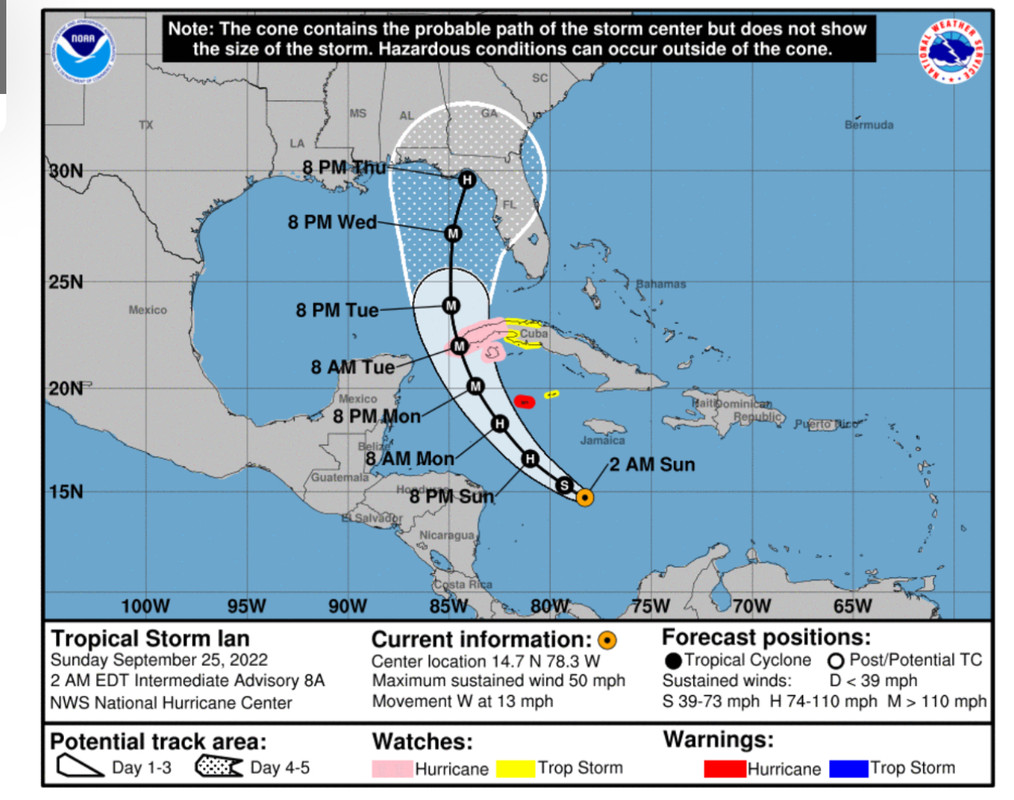
Let’s just remember all the model runs on Ian 4.5 days out…
2 likes
Hurricane Eye Experience: David 79, Irene 99, Frances 04, Jeanne 04, Wilma 05… Hurricane Brush Experience: Andrew 92, Erin 95, Floyd 99, Matthew 16, Irma 17, Ian 22, Nicole 22…
-
StormPyrate
- Category 1
- Posts: 286
- Joined: Sun May 27, 2018 8:41 pm
- Location: Clearwater, FL
Re: Low pressure developing over the western Caribbean Sea (10/70)
When do yall think we will see an invest?
seems a tad overdue
seems a tad overdue
0 likes
St Petersburg Florida
Who is online
Users browsing this forum: No registered users and 136 guests