

Tropical Weather Outlook
Statement as of 5:30 am EDT on August 29, 2006
For the North Atlantic...Caribbean Sea and the Gulf of Mexico...
The National Hurricane Center is issuing advisories on Tropical
Storm Ernesto...located about 20 miles north of Camaguey Cuba.
A westward-moving tropical wave located about 625 miles southwest of
the Cape Verde Islands is producing a concentrated area of showers
and thunderstorms. This system is showing signs of organization
...And some additional development is possible during the next
couple of days.
Elsewhere...tropical storm formation is not expected through
Wednesday.
$$
Forecaster Stewart
Central Atlantic Wave,Midway Between Africa and L Antilles
Moderator: S2k Moderators
Forum rules

The posts in this forum are NOT official forecasts and should not be used as such. They are just the opinion of the poster and may or may not be backed by sound meteorological data. They are NOT endorsed by any professional institution or STORM2K. For official information, please refer to products from the National Hurricane Center and National Weather Service.
-
HurricaneMaster_PR

- Category 2

- Posts: 795
- Joined: Tue Jul 22, 2003 6:23 pm
- Location: San Juan, Puerto Rico
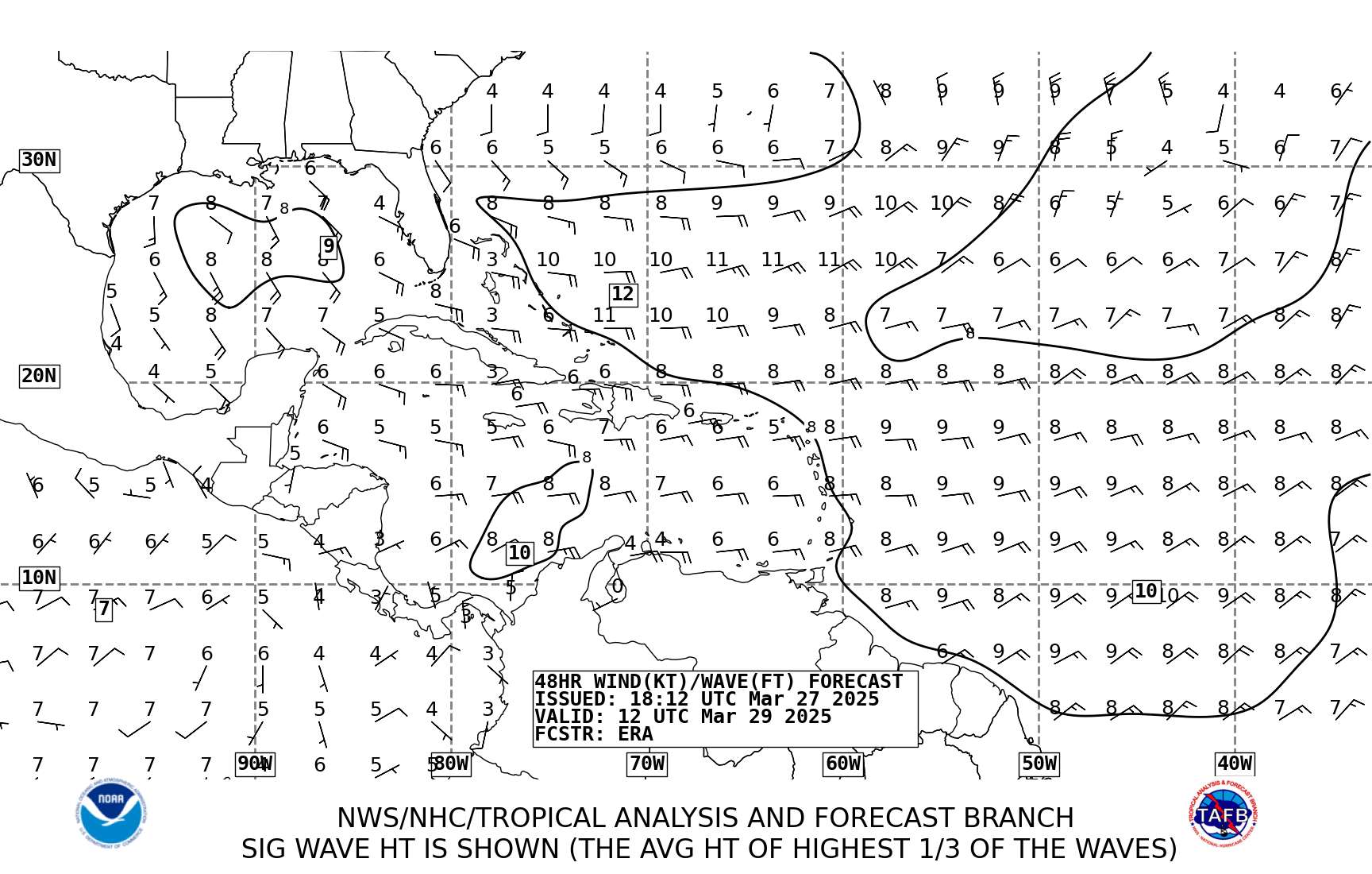
TAFB showing possible area of low pressure moving to the west in the next 48 hours...
48 hours
http://www.nhc.noaa.gov/tafb_latest/atl48_latestBW.gif
72 hours
http://www.nhc.noaa.gov/tafb_latest/atl72_latestBW.gif
48 hours
http://www.nhc.noaa.gov/tafb_latest/atl48_latestBW.gif
72 hours
http://www.nhc.noaa.gov/tafb_latest/atl72_latestBW.gif
0 likes
-
cycloneye

- Admin

- Posts: 148763
- Age: 69
- Joined: Thu Oct 10, 2002 10:54 am
- Location: San Juan, Puerto Rico
A LOW AMPLITUDE TROPICAL WAVE IS ALONG 27W/28W S OF 15N...MOVING
W NEAR 15 KT. THIS WAVE IS DIFFICULT TO LOCATE AS IT IS
SUPERIMPOSED ON THE MONSOON TROUGH. HOWEVER...BROAD CYCLONIC
CURVATURE IS EVIDENT IN NEARBY SURFACE OBSERVATIONS AND LOW TO
MID CLOUD MOTIONS ON SATELLITE IMAGERY. A NEW BURST OF SCATTERED
MODERATE/ISOLATED STRONG CONVECTION HAS DEVELOPED FROM 11N-13N
BETWEEN 25W-29W. A SMALLER CLUSTER IS NOTED NEAR 8N28W.
8 AM Discussion.
0 likes
Visit the Caribbean-Central America Weather Thread where you can find at first post web cams,radars
and observations from Caribbean basin members Click Here
and observations from Caribbean basin members Click Here
-
cycloneye
- Admin
- Posts: 148763
- Age: 69
- Joined: Thu Oct 10, 2002 10:54 am
- Location: San Juan, Puerto Rico

Folks,dont be fooled as you see that convection at 35w because is not the area we have to watch.The area of interest is in the wave axis around 28w where you see convection at the extreme right part of the pic.
0 likes
Visit the Caribbean-Central America Weather Thread where you can find at first post web cams,radars
and observations from Caribbean basin members Click Here
and observations from Caribbean basin members Click Here

-
SouthFloridawx

- S2K Supporter

- Posts: 8346
- Age: 47
- Joined: Tue Jul 26, 2005 1:16 am
- Location: Sarasota, FL
- Contact:
-
cycloneye
- Admin
- Posts: 148763
- Age: 69
- Joined: Thu Oct 10, 2002 10:54 am
- Location: San Juan, Puerto Rico
Bane wrote:isn't this the one the gfs has been developing and taking towards the east coast ?
Yes,look at the 6z run loop.
http://www.nco.ncep.noaa.gov/pmb/nwprod ... loop.shtml
0 likes

cycloneye wrote:Bane wrote:isn't this the one the gfs has been developing and taking towards the east coast ?
Yes,look at the 6z run loop.
http://www.nco.ncep.noaa.gov/pmb/nwprod ... loop.shtml
The last couple of frames are kind of nutty - strange leaps.
0 likes

-
O Town
- S2K Supporter
- Posts: 5205
- Age: 52
- Joined: Wed Sep 07, 2005 9:37 pm
- Location: Orlando, Florida 28°35'35"N 81°22'55"W
cycloneye wrote:Folks,dont be fooled as you see that convection at 35w because is not the area we have to watch.The area of interest is in the wave axis around 28w where you see convection at the extreme right part of the pic.
So are you saying its the blob I circled and NOT the wave in front? Because the wave in front doesn't look so bad either.

0 likes
-
cycloneye
- Admin
- Posts: 148763
- Age: 69
- Joined: Thu Oct 10, 2002 10:54 am
- Location: San Juan, Puerto Rico
Thunder44 wrote:Nice close-up visible thanks to google:
Again to clarify to the members about where is the area of interest.In this pic what you see at the left is ITCZ,monsoon related convection,What you see at the right getting out of the black area is the area to watch as it's in the wave axis. Thanks Thunder44 for posting the google pic.
0 likes
Visit the Caribbean-Central America Weather Thread where you can find at first post web cams,radars
and observations from Caribbean basin members Click Here
and observations from Caribbean basin members Click Here
-
cycloneye
- Admin
- Posts: 148763
- Age: 69
- Joined: Thu Oct 10, 2002 10:54 am
- Location: San Juan, Puerto Rico
The circuled one is it O Town. 
0 likes
Visit the Caribbean-Central America Weather Thread where you can find at first post web cams,radars
and observations from Caribbean basin members Click Here
and observations from Caribbean basin members Click Here

-
cycloneye
- Admin
- Posts: 148763
- Age: 69
- Joined: Thu Oct 10, 2002 10:54 am
- Location: San Juan, Puerto Rico
Again,thanks Thunder44 for those google pics.Great closeup of the area of interest.
0 likes
Visit the Caribbean-Central America Weather Thread where you can find at first post web cams,radars
and observations from Caribbean basin members Click Here
and observations from Caribbean basin members Click Here


Who is online
Users browsing this forum: bird and 98 guests