Potential development over the Western Caribbean Sea (Is Invest 99L)

This is the general tropical discussion area. Anyone can take their shot at predicting a storms path.

Moderator: S2k Moderators

Forum rules

The posts in this forum are NOT official forecasts and should not be used as such. They are just the opinion of the poster and may or may not be backed by sound meteorological data. They are NOT endorsed by any professional institution or STORM2K. For official information, please refer to products from the National Hurricane Center and National Weather Service.

Help Support Storm2K
Message
Author
User avatar
cycloneye
Admin
Admin
Posts: 145250
Age: 68
Joined: Thu Oct 10, 2002 10:54 am
Location: San Juan, Puerto Rico

Re: Potential development over the Western Caribbean Sea (40/80)

#101 Postby cycloneye » Tue Nov 12, 2024 6:53 am

Tropical Weather Outlook
NWS National Hurricane Center Miami FL
700 AM EST Tue Nov 12 2024

For the North Atlantic...Caribbean Sea and the Gulf of Mexico:

1. Central and Western Caribbean Sea:
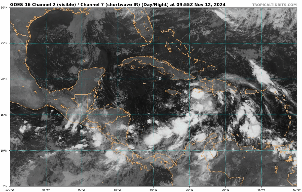
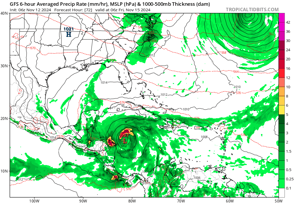
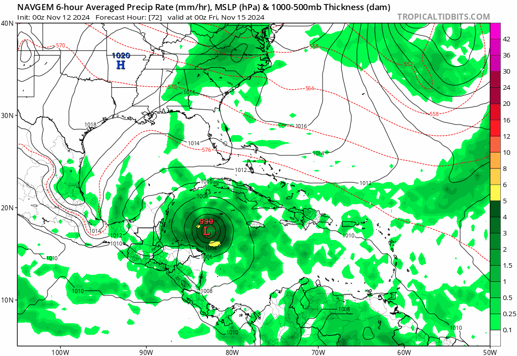
A tropical wave over the central Caribbean Sea is producing an area
of disorganized showers and thunderstorms. Environmental
conditions appear conducive for development, and a tropical
depression is likely to form by the end of the week as the system
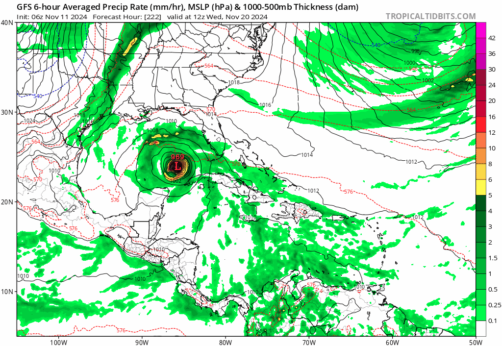
moves slowly westward into the western Caribbean Sea. Afterward,
the disturbance is expected to meander over the western Caribbean
Sea through the weekend and begin moving slowly, generally
northwestward, by early next week. Interests across the western
Caribbean Sea should monitor the progress of this system.
* Formation chance through 48 hours...Medium...40 percent.
* Formation chance through 7 days...high...80 percent.


Forecaster Roberts
0 likes   
Visit the Caribbean-Central America Weather Thread where you can find at first post web cams,radars
and observations from Caribbean basin members Click Here

xironman
S2K Supporter
S2K Supporter
Posts: 2522
Joined: Sun Jun 10, 2007 4:53 pm
Location: NoVA

Re: Potential development over the Western Caribbean Sea (40/80)

#102 Postby xironman » Tue Nov 12, 2024 7:01 am

Thinking we may get an invest soon. It looks trackable and it would be nice to have the hurricane models.
1 likes   

underthwx
Category 5
Category 5
Posts: 2360
Joined: Sat Jul 30, 2011 2:14 pm
Location: Brazoria County Texas

Re: Potential development over the Western Caribbean Sea (20/60)

#103 Postby underthwx » Tue Nov 12, 2024 7:18 am

chaser1 wrote:Sara could seriously be bad Juju for Florida or Cuba. After the region has seen hurricanes, tornadoes, and major earthquakes.....what's next, an asteroid?

I wonder who covers asteroids? The last one took out the dinosaurs. But seriously, this next system from what yall are discussing may affect Florida? The NHC outlook mentions a meandering system, which tells me whatever forms, will have ample time to strengthen.
Last edited by underthwx on Tue Nov 12, 2024 7:23 am, edited 1 time in total.
0 likes   

xironman
S2K Supporter
S2K Supporter
Posts: 2522
Joined: Sun Jun 10, 2007 4:53 pm
Location: NoVA

Re: Potential development over the Western Caribbean Sea (20/60)

#104 Postby xironman » Tue Nov 12, 2024 7:22 am

underthwx wrote:
chaser1 wrote:Sara could seriously be bad Juju for Florida or Cuba. After the region has seen hurricanes, tornadoes, and major earthquakes.....what's next, an asteroid?

I wonder who covers asteroids? The last one took out the dinosaurs.


SpaceWeather has listings of near earth asteroids https://spaceweather.com/ along with tons of stuff on solar activity
1 likes   

underthwx
Category 5
Category 5
Posts: 2360
Joined: Sat Jul 30, 2011 2:14 pm
Location: Brazoria County Texas

Re: Potential development over the Western Caribbean Sea (20/60)

#105 Postby underthwx » Tue Nov 12, 2024 7:25 am

xironman wrote:
underthwx wrote:
chaser1 wrote:Sara could seriously be bad Juju for Florida or Cuba. After the region has seen hurricanes, tornadoes, and major earthquakes.....what's next, an asteroid?

I wonder who covers asteroids? The last one took out the dinosaurs.


SpaceWeather has listings of near earth asteroids https://spaceweather.com/ along with tons of stuff on solar activity

I was just joking, but thanks, I will check it out!
1 likes   

User avatar
GCANE
S2K Supporter
S2K Supporter
Posts: 11487
Joined: Mon Oct 22, 2007 8:03 am

Re: Potential development over the Western Caribbean Sea (40/80)

#106 Postby GCANE » Tue Nov 12, 2024 7:26 am

Looks like dry air may have some effect on this.
https://www.tropicaltidbits.com/analysi ... 206&fh=204

This effect will likely be trumped by the period it is over the Loop Current where it will likely strengthen under an anticyclone.
https://www.tropicaltidbits.com/analysi ... 206&fh=174

Once it moves east away from the Loop Current, waters are cooler and dry air will likely cause it to weaken on approach to landfall.
https://www.aoml.noaa.gov/phod/dhos/alt ... ents%20are
1 likes   

underthwx
Category 5
Category 5
Posts: 2360
Joined: Sat Jul 30, 2011 2:14 pm
Location: Brazoria County Texas

Re: Potential development over the Western Caribbean Sea (40/80)

#107 Postby underthwx » Tue Nov 12, 2024 7:33 am

NWS Tampa beginning to mention the disturbance in the Carribean in its 2am forecast discussion:

"By the end of the forecast period, all eyes may
have to begin looking south as a tropical wave currently over the
central Caribbean is likely to develop into a tropical system, and
move into the western Caribbean.'

Its a familiar theme this hurricane season unfortunately.
2 likes   

Cachondo23
Tropical Depression
Tropical Depression
Posts: 75
Joined: Wed May 25, 2022 5:56 am

Re: Potential development over the Western Caribbean Sea (40/80)

#108 Postby Cachondo23 » Tue Nov 12, 2024 7:58 am

80% chance and still no invest?
0 likes   

User avatar
gatorcane
S2K Supporter
S2K Supporter
Posts: 23691
Age: 47
Joined: Sun Mar 13, 2005 3:54 pm
Location: Boca Raton, FL

Re: Potential development over the Western Caribbean Sea (40/80)

#109 Postby gatorcane » Tue Nov 12, 2024 7:58 am

Invest should be declared soon on this area. I expect one today. The models are rather concerning. Let’s see what the hurricane models do with it.

Image
Last edited by gatorcane on Tue Nov 12, 2024 8:02 am, edited 1 time in total.
1 likes   

underthwx
Category 5
Category 5
Posts: 2360
Joined: Sat Jul 30, 2011 2:14 pm
Location: Brazoria County Texas

Re: Potential development over the Western Caribbean Sea (40/80)

#110 Postby underthwx » Tue Nov 12, 2024 8:02 am

Cachondo23 wrote:80% chance and still no invest?

Ought to be an invest later today is my guess. Not much to look at on satellite atm tho. Maybe an invest tomorrow? I dunno. I think gatorcane is right tho. (And Kevin)
Last edited by underthwx on Tue Nov 12, 2024 8:04 am, edited 2 times in total.
0 likes   

User avatar
kevin
Category 5
Category 5
Posts: 2586
Age: 26
Joined: Wed Aug 28, 2019 4:35 am

Re: Potential development over the Western Caribbean Sea (40/80)

#111 Postby kevin » Tue Nov 12, 2024 8:03 am

Even if it might not look 100% invest-worthy, I do expect NHC to call it an invest later today so they can get the hurricane model runs started.
1 likes   

User avatar
gatorcane
S2K Supporter
S2K Supporter
Posts: 23691
Age: 47
Joined: Sun Mar 13, 2005 3:54 pm
Location: Boca Raton, FL

Re: Potential development over the Western Caribbean Sea (40/80)

#112 Postby gatorcane » Tue Nov 12, 2024 8:06 am

Saved 06Z GFS loop: :double:

Image
1 likes   

User avatar
gatorcane
S2K Supporter
S2K Supporter
Posts: 23691
Age: 47
Joined: Sun Mar 13, 2005 3:54 pm
Location: Boca Raton, FL

Re: Potential development over the Western Caribbean Sea (40/80)

#113 Postby gatorcane » Tue Nov 12, 2024 8:09 am

GFS trend last 5 runs:

Image
1 likes   

User avatar
WaveBreaking
Category 2
Category 2
Posts: 578
Joined: Sun Jun 30, 2024 11:33 am
Location: US

Re: Potential development over the Western Caribbean Sea (40/80)

#114 Postby WaveBreaking » Tue Nov 12, 2024 8:12 am


Also peep the subtropical cyclone the GFS consistently shows in the top right
0 likes   
I am NOT a professional meteorologist, so take all of my posts with a grain of salt. My opinions are mine and mine alone.

User avatar
Category5Kaiju
Category 5
Category 5
Posts: 4094
Joined: Thu Dec 24, 2020 12:45 pm
Location: Seattle

Re: Potential development over the Western Caribbean Sea (40/80)

#115 Postby Category5Kaiju » Tue Nov 12, 2024 8:16 am

If that last GFS run verified, then we'd be looking at a season that features the earliest AND the latest Category 5 on record. Insanity.

I am getting increasingly concerned about the possibility of a significant hurricane. Really hope this is the last "hurrah" of this phenomenal hurricane season.
2 likes   
Unless explicitly stated, all info in my posts is based on my own opinions and observations. Tropical storms and hurricanes can be extremely dangerous. Do not think you can beat Mother Nature. Refer to an accredited weather research agency or meteorologist if you need to make serious decisions regarding an approaching storm.

User avatar
gatorcane
S2K Supporter
S2K Supporter
Posts: 23691
Age: 47
Joined: Sun Mar 13, 2005 3:54 pm
Location: Boca Raton, FL

Re: Potential development over the Western Caribbean Sea (40/80)

#116 Postby gatorcane » Tue Nov 12, 2024 8:17 am

00z NAVGEM :eek:

Image
0 likes   

tolakram
Admin
Admin
Posts: 20009
Age: 62
Joined: Sun Aug 27, 2006 8:23 pm
Location: Florence, KY (name is Mark)

Re: Potential development over the Western Caribbean Sea (40/80)

#117 Postby tolakram » Tue Nov 12, 2024 8:32 am


So it's not going to Florida then (joke).

I can't find any good parallels to a storm forming in the Caribbean and then moving toward the US coast in November.

Mitch formed in late October and had it avoided landfall it would probably be the closest parallel. Right now only the Euro AI, which does not have a good track record, is showing a similar solution. The Euro does show a back and forth motion which might evolve into a landfall somewhere in Honduras / Nicaragua before moving north. Regardless, crazy we're even looking at this on November 12th!
0 likes   
M a r k
- - - - -
Join us in chat: Storm2K Chatroom Invite. Android and IOS apps also available.

The posts in this forum are NOT official forecasts and should not be used as such. Posts are NOT endorsed by any professional institution or STORM2K.org. For official information and forecasts, please refer to NHC and NWS products.

User avatar
chris_fit
Category 5
Category 5
Posts: 3222
Age: 42
Joined: Wed Sep 10, 2003 11:58 pm
Location: Tampa Bay Area, FL

Re: Potential development over the Western Caribbean Sea (40/80)

#118 Postby chris_fit » Tue Nov 12, 2024 8:37 am

Hopefully Wxman57 has not signed off for the season yet. Curious on his thoughts.
0 likes   

tolakram
Admin
Admin
Posts: 20009
Age: 62
Joined: Sun Aug 27, 2006 8:23 pm
Location: Florence, KY (name is Mark)

Re: Potential development over the Western Caribbean Sea (40/80)

#119 Postby tolakram » Tue Nov 12, 2024 8:51 am

1 likes   
M a r k
- - - - -
Join us in chat: Storm2K Chatroom Invite. Android and IOS apps also available.

The posts in this forum are NOT official forecasts and should not be used as such. Posts are NOT endorsed by any professional institution or STORM2K.org. For official information and forecasts, please refer to NHC and NWS products.

User avatar
HurricaneBelle
S2K Supporter
S2K Supporter
Posts: 1177
Joined: Sun Aug 27, 2006 6:12 pm
Location: Clearwater, FL

Re: Potential development over the Western Caribbean Sea (40/80)

#120 Postby HurricaneBelle » Tue Nov 12, 2024 8:53 am

Finally had the debris on my block from Milton picked up yesterday, so at least I've got that going for me.
2 likes   


Return to “Talkin' Tropics”

Who is online

Users browsing this forum: Google [Bot] and 31 guests