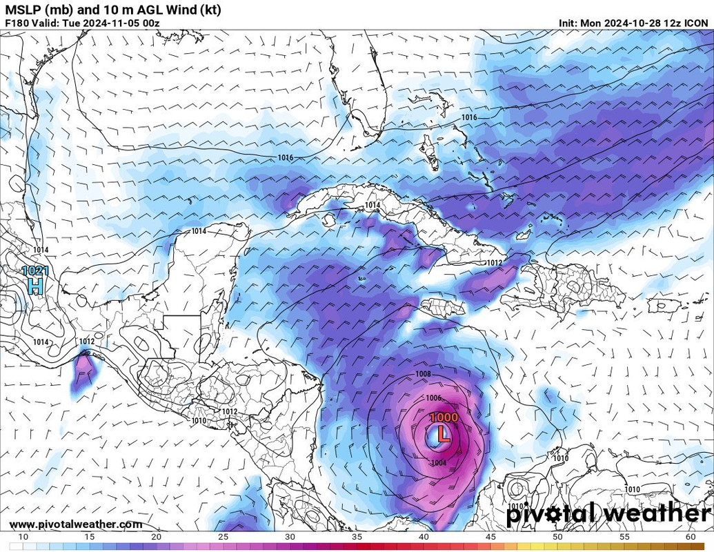
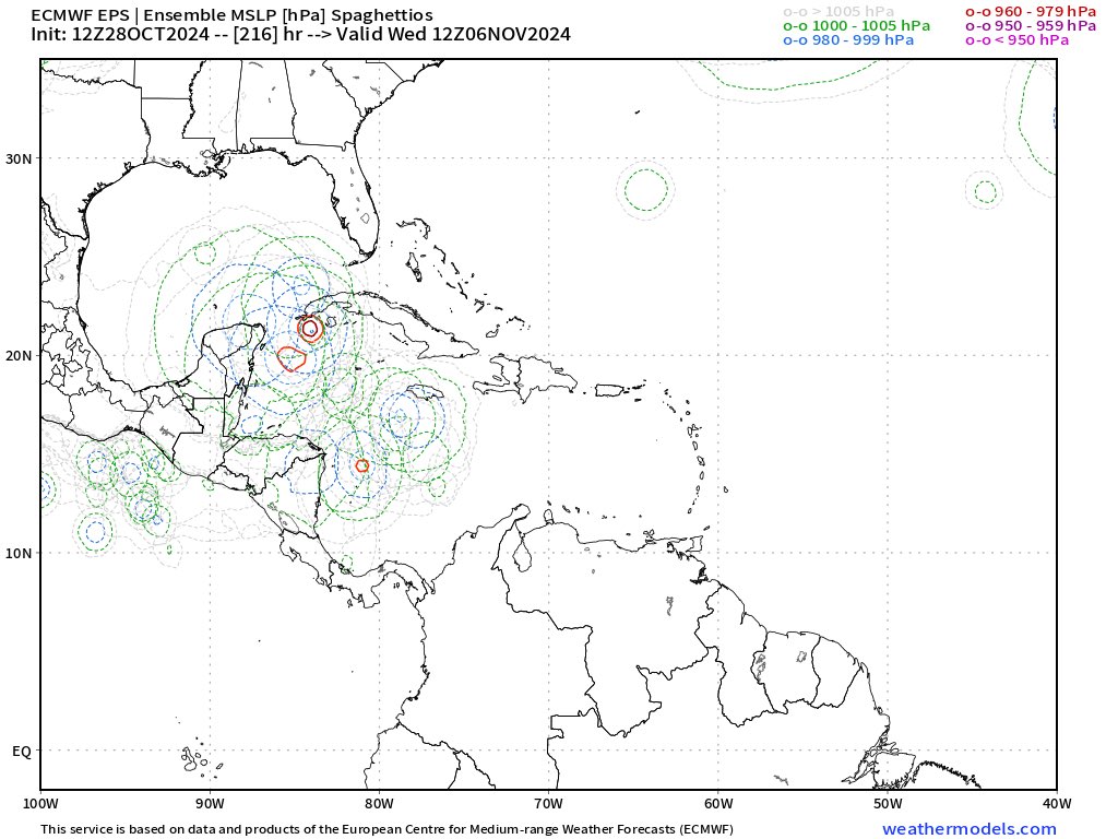
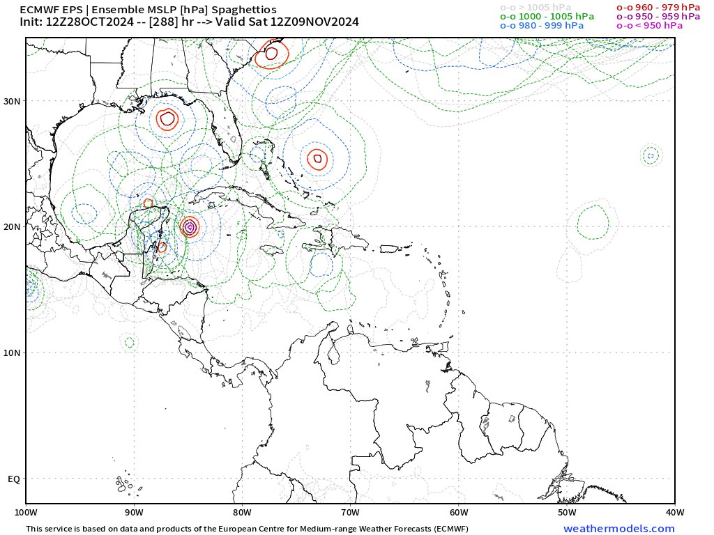
Low Pressure developing in the Southwest Caribbean Sea (Is Invest 97L)

This is the general tropical discussion area. Anyone can take their shot at predicting a storms path.

Moderator: S2k Moderators

Forum rules

The posts in this forum are NOT official forecasts and should not be used as such. They are just the opinion of the poster and may or may not be backed by sound meteorological data. They are NOT endorsed by any professional institution or STORM2K. For official information, please refer to products from the National Hurricane Center and National Weather Service.

Help Support Storm2K
Message
Author
User avatar
WaveBreaking
Category 2
Category 2
Posts: 578
Joined: Sun Jun 30, 2024 11:33 am
Location: US

Re: Low Pressure to develop in the Southwest Caribbean Sea (0/40)

#101 Postby WaveBreaking » Mon Oct 28, 2024 7:02 am

wzrgirl1 wrote:
xironman wrote:Canadian very consistent on a large storm

https://i.imgur.com/jgFEbzz.png


Just watched Cantore who said, IF something forms it would be very large and if the high pressure begins to erode it would force the system north to then northwest towards the east coast. Please do not read into this anymore then what it is. It is still 7-10 days away.


A massive East Coast storm in November after mainly Gulf and Caribbean hits would be on brand with this year.
0 likes   
I am NOT a professional meteorologist, so take all of my posts with a grain of salt. My opinions are mine and mine alone.

User avatar
CourierPR
Category 5
Category 5
Posts: 1335
Age: 71
Joined: Tue Aug 31, 2004 7:53 pm
Location: Pompano Beach, Florida

Re: Low Pressure to develop in the Southwest Caribbean Sea (0/40)

#102 Postby CourierPR » Mon Oct 28, 2024 8:41 am

Meteorologist Joe Bastardi forecasts the system to develop this weekend and to be a threat after the election.
Last edited by CourierPR on Mon Oct 28, 2024 8:44 am, edited 1 time in total.
0 likes   

User avatar
SFLcane
S2K Supporter
S2K Supporter
Posts: 10163
Age: 47
Joined: Sat Jun 05, 2010 1:44 pm
Location: Lake Worth Florida

Re: Low Pressure to develop in the Southwest Caribbean Sea (0/40)

#103 Postby SFLcane » Mon Oct 28, 2024 10:38 am

Image
2 likes   

User avatar
Hypercane_Kyle
Category 5
Category 5
Posts: 3352
Joined: Sat Mar 07, 2015 7:58 pm
Location: Cape Canaveral, FL

Re: Low Pressure to develop in the Southwest Caribbean Sea (0/40)

#104 Postby Hypercane_Kyle » Mon Oct 28, 2024 11:16 am

A pretty clear and consistent trend on the GFS of weaker, further east.

CMC is kind of on its own with a gigantic WCARB monster.
0 likes   
My posts are my own personal opinion, defer to the National Hurricane Center (NHC) and other NOAA products for decision making during hurricane season.

User avatar
toad strangler
S2K Supporter
S2K Supporter
Posts: 4543
Joined: Sun Jul 28, 2013 3:09 pm
Location: Earth
Contact:

Re: Low Pressure to develop in the Southwest Caribbean Sea (0/40)

#105 Postby toad strangler » Mon Oct 28, 2024 11:19 am

Hypercane_Kyle wrote:A pretty clear and consistent trend on the GFS of weaker, further east.

CMC is kind of on its own with a gigantic WCARB monster.


Weaker and further to the E from a SW Caribbean origin would be near textbook climo heading into NOV.
0 likes   

User avatar
Jr0d
S2K Supporter
S2K Supporter
Posts: 1409
Joined: Tue Aug 27, 2019 10:52 am
Location: Cayo Hueso

Re: Low Pressure to develop in the Southwest Caribbean Sea (0/40)

#106 Postby Jr0d » Mon Oct 28, 2024 11:28 am

Hypercane_Kyle wrote:A pretty clear and consistent trend on the GFS of weaker, further east.

CMC is kind of on its own with a gigantic WCARB monster.

While I hope the GFS operational is out the right track, given the GFS Ensembles are all over the place the forecast is subject to higher than normal error. Until there is some sort of consistency, the long range GFS should be ignored.

About a third of the ensembles take it NW instead of northeast....and a significant number of the them also show a hurricane, most take the NW path.

Until we have an actual area of disturbed weather, an invest for the models to lock on to, they are not going to be reliable especially 10 days out..
2 likes   

User avatar
toad strangler
S2K Supporter
S2K Supporter
Posts: 4543
Joined: Sun Jul 28, 2013 3:09 pm
Location: Earth
Contact:

Re: Low Pressure to develop in the Southwest Caribbean Sea (0/40)

#107 Postby toad strangler » Mon Oct 28, 2024 11:40 am

12z CMC is much further East than 0z
Takes a storm into Haiti.
Last edited by toad strangler on Mon Oct 28, 2024 11:41 am, edited 1 time in total.
0 likes   

SconnieCane
Category 4
Category 4
Posts: 998
Joined: Thu Aug 02, 2018 5:29 pm
Location: Madison, WI

Re: Low Pressure to develop in the Southwest Caribbean Sea (0/40)

#108 Postby SconnieCane » Mon Oct 28, 2024 11:41 am

Jr0d wrote:
Hypercane_Kyle wrote:A pretty clear and consistent trend on the GFS of weaker, further east.

CMC is kind of on its own with a gigantic WCARB monster.

While I hope the GFS operational is out the right track, given the GFS Ensembles are all over the place the forecast is subject to higher than normal error. Until there is some sort of consistency, the long range GFS should be ignored.

About a third of the ensembles take it NW instead of northeast....and a significant number of the them also show a hurricane, most take the NW path.

Until we have an actual area of disturbed weather, an invest for the models to lock on to, they are not going to be reliable especially 10 days out..


Yeah, don't forget how pre-Milton downtrended on the models as it got closer until a few days out, then popped back up again with a vengeance.
5 likes   

User avatar
kevin
Category 5
Category 5
Posts: 2586
Age: 26
Joined: Wed Aug 28, 2019 4:35 am

Re: Low Pressure to develop in the Southwest Caribbean Sea (0/40)

#109 Postby kevin » Mon Oct 28, 2024 11:53 am

12z ICON also shows the system, but much further southwest than 12z GFS.

Image
2 likes   

User avatar
cycloneye
Admin
Admin
Posts: 145271
Age: 68
Joined: Thu Oct 10, 2002 10:54 am
Location: San Juan, Puerto Rico

Re: Low Pressure to develop in the Southwest Caribbean Sea (0/40)

#110 Postby cycloneye » Mon Oct 28, 2024 11:58 am

Until a low forms, the models will be like a wiper in different directions.
12 likes   
Visit the Caribbean-Central America Weather Thread where you can find at first post web cams,radars
and observations from Caribbean basin members Click Here

psyclone
S2K Supporter
S2K Supporter
Posts: 4762
Joined: Wed Aug 24, 2005 9:04 pm
Location: palm harbor fl

Re: Low Pressure to develop in the Southwest Caribbean Sea (0/40)

#111 Postby psyclone » Mon Oct 28, 2024 12:41 pm

As we near November it is safe and fair to acknowledge it is very tough...but not impossible...to push a cane toward FL. The cocoon of seasonal favorabilty contracts very rapidly south and west deep into the Caribbean. Michelle 2001 is a great example of a scenario more likely than a risk to FL.
0 likes   

TomballEd
Category 2
Category 2
Posts: 686
Age: 61
Joined: Wed Aug 16, 2023 4:52 pm
Location: Spring/Klein area, not Tomball

Re: Low Pressure to develop in the Southwest Caribbean Sea (0/40)

#112 Postby TomballEd » Mon Oct 28, 2024 12:49 pm

psyclone wrote:As we near November it is safe and fair to acknowledge it is very tough...but not impossible...to push a cane toward FL. The cocoon of seasonal favorabilty contracts very rapidly south and west deep into the Caribbean. Michelle 2001 is a great example of a scenario more likely than a risk to FL.


They run the season through November just for Florida. Different path, but Hurricane Kate had some people eating Thanksgiving dinner in the dark.
https://en.wikipedia.org/wiki/Hurricane_Kate_(1985)
0 likes   

User avatar
sasha_B
Tropical Depression
Tropical Depression
Posts: 76
Age: 24
Joined: Sun Jun 30, 2024 4:32 pm
Location: Charleston, SC

Re: Low Pressure to develop in the Southwest Caribbean Sea (0/40)

#113 Postby sasha_B » Mon Oct 28, 2024 12:54 pm

Still nothing that can be called a trend yet, as far as I can tell, aside from a trend towards some sort of closed low forming from the end of this week into the first week of November - the ICON has picking up on that on recent runs, GFS and Euro ensembles both support it, the CMC has been showing a hurricane for a couple of days now, and the GFS has been very consistent on that for even longer (even if it's windshield-wiping between eastward/westward and weaker/stronger solutions, it's shown a sub-990 hPa system somewhere in the Caribbean with 100% consitency run-to-run). AI-Euro also suggests a broad area of low pressure at least, which given its low resolution is a decent signal for development as well.
The NHC's 0/40 seems like a perfectly reasonable estimate of the probability of TCG, and two of the three models that show development tend to show at minimum a nameable system and on some iterations, a major hurricane. As others have pointed out, track remains up in the air until there's an actual disturbance. If the GFS continues to show weaker storms on the next 3-4 runs and the ensembles drop off, that would be a trend, but right now it just seems to be reflective of the typical forecast uncertainty at this range.
6 likes   

User avatar
cycloneye
Admin
Admin
Posts: 145271
Age: 68
Joined: Thu Oct 10, 2002 10:54 am
Location: San Juan, Puerto Rico

Re: Low Pressure to develop in the Southwest Caribbean Sea (0/40)

#114 Postby cycloneye » Mon Oct 28, 2024 12:58 pm

Copy and paste from 8 AM. I think they are waiting for the Euro.

Tropical Weather Outlook
NWS National Hurricane Center Miami FL
200 PM EDT Mon Oct 28 2024

For the North Atlantic...Caribbean Sea and the Gulf of Mexico:

1. Southwestern Caribbean Sea:
A broad area of low pressure is likely to develop over the
southwestern Caribbean Sea in a few days. Gradual development is
possible thereafter, and a tropical depression could form late this
week or over the weekend while the system begins to drift northward
or northeastward toward the central Caribbean Sea.
* Formation chance through 48 hours...low...near 0 percent.
* Formation chance through 7 days...medium...40 percent.


Forecaster Hagen/Adams
2 likes   
Visit the Caribbean-Central America Weather Thread where you can find at first post web cams,radars
and observations from Caribbean basin members Click Here

User avatar
SFLcane
S2K Supporter
S2K Supporter
Posts: 10163
Age: 47
Joined: Sat Jun 05, 2010 1:44 pm
Location: Lake Worth Florida

Re: Low Pressure to develop in the Southwest Caribbean Sea (0/40)

#115 Postby SFLcane » Mon Oct 28, 2024 2:18 pm

Healthy signal remains on the eps this afternoon..

Image

Image
5 likes   

User avatar
AJC3
Admin
Admin
Posts: 3999
Age: 61
Joined: Tue Aug 31, 2004 7:04 pm
Location: Ballston Spa, New York
Contact:

Re: Low Pressure to develop in the Southwest Caribbean Sea (0/40)

#116 Postby AJC3 » Mon Oct 28, 2024 2:48 pm

Another quick reminder, gang...

Whenever you see a post that's obvious disinformation or trolling, rather than reply to it, just hit the report button and it'll be taken care of. When a post like that is replied to, it gets quoted, which (1) Gives it more exposure than it deserves; and (2) Makes more work for the mods/admins to remove all mentions if it.

As always, we thank you. :-)
27 likes   

User avatar
wxman57
Moderator-Pro Met
Moderator-Pro Met
Posts: 22976
Age: 67
Joined: Sat Jun 21, 2003 8:06 pm
Location: Houston, TX (southwest)

Re: Low Pressure to develop in the Southwest Caribbean Sea (0/40)

#117 Postby wxman57 » Mon Oct 28, 2024 2:48 pm

I've been away from here for the past week as I vacationed in Florida. However, I was monitoring models from there. It does seem that this potential system will not be impacting Florida. It may not even develop. Predicted flow pattern next week would favor either a track west into Central America or northeast, passing well south of Florida. Personally, I'm all for no developing, as I'm in the lead in the office hurricane contest and any development after October 30th, breaks the tie and causes me to lose to a tiebreaker for the second year in a row. I need to pick a later date for the last named storm formation. I have the 28th, my tied coworker has Nov. 2.
9 likes   

User avatar
Hypercane_Kyle
Category 5
Category 5
Posts: 3352
Joined: Sat Mar 07, 2015 7:58 pm
Location: Cape Canaveral, FL

Re: Low Pressure to develop in the Southwest Caribbean Sea (0/40)

#118 Postby Hypercane_Kyle » Mon Oct 28, 2024 3:16 pm

It'll probably develop. Good signal on the CMC/GFS/ICON and ensembles. Euro doesn't have it, but it has a bias against these types of genesis scenarios.
4 likes   
My posts are my own personal opinion, defer to the National Hurricane Center (NHC) and other NOAA products for decision making during hurricane season.

underthwx
Category 5
Category 5
Posts: 2360
Joined: Sat Jul 30, 2011 2:14 pm
Location: Brazoria County Texas

Re: Low Pressure to develop in the Southwest Caribbean Sea (0/40)

#119 Postby underthwx » Mon Oct 28, 2024 4:02 pm

This is an excerpt from this mornings 540 AM NWS San Juan PR forecast discussion,
which I like to read everyday. It makes mention of the current area of interest in
the SW Carribean. I thought I would share it with y'all.

A wet and unstable period could unfold during the end of the
month/beginning of November as the National Hurricane Center is
monitoring an area of low pressure that is likely to develop over
the southwestern Caribbean Sea. They anticipate a gradual
development late this week or over the weekend as the system
begins to drift northward or northeastward and potentially
approach the forecast area. This area of low pressure now has a 40
percent chance of development in the next 7 days. However, it is
far in the forecast, and we encourage people to stay informed with
each update.
4 likes   

User avatar
blp
Category 5
Category 5
Posts: 2840
Age: 46
Joined: Thu Sep 09, 2004 7:51 pm
Location: Miami, FL
Contact:

Re: Low Pressure to develop in the Southwest Caribbean Sea (0/40)

#120 Postby blp » Mon Oct 28, 2024 6:24 pm

18z GFS starting to come around. Now develops the northern vort which was what the other models were showing a few days ago and then at the end develops the southern vort but later in the run. I expect the 00z to line up with the others and develop the southern vort. This should head into the W. Caribbean then we see what it does.
0 likes   
The following post is NOT an official forecast and should not be used as such. It is just the opinion of the poster and may or may not be backed by sound meteorological data. It is NOT endorsed by any professional institution including storm2k.org For Official Information please refer to the NHC and NWS products.


Return to “Talkin' Tropics”

Who is online

Users browsing this forum: JtSmarts, nativefloridian and 29 guests