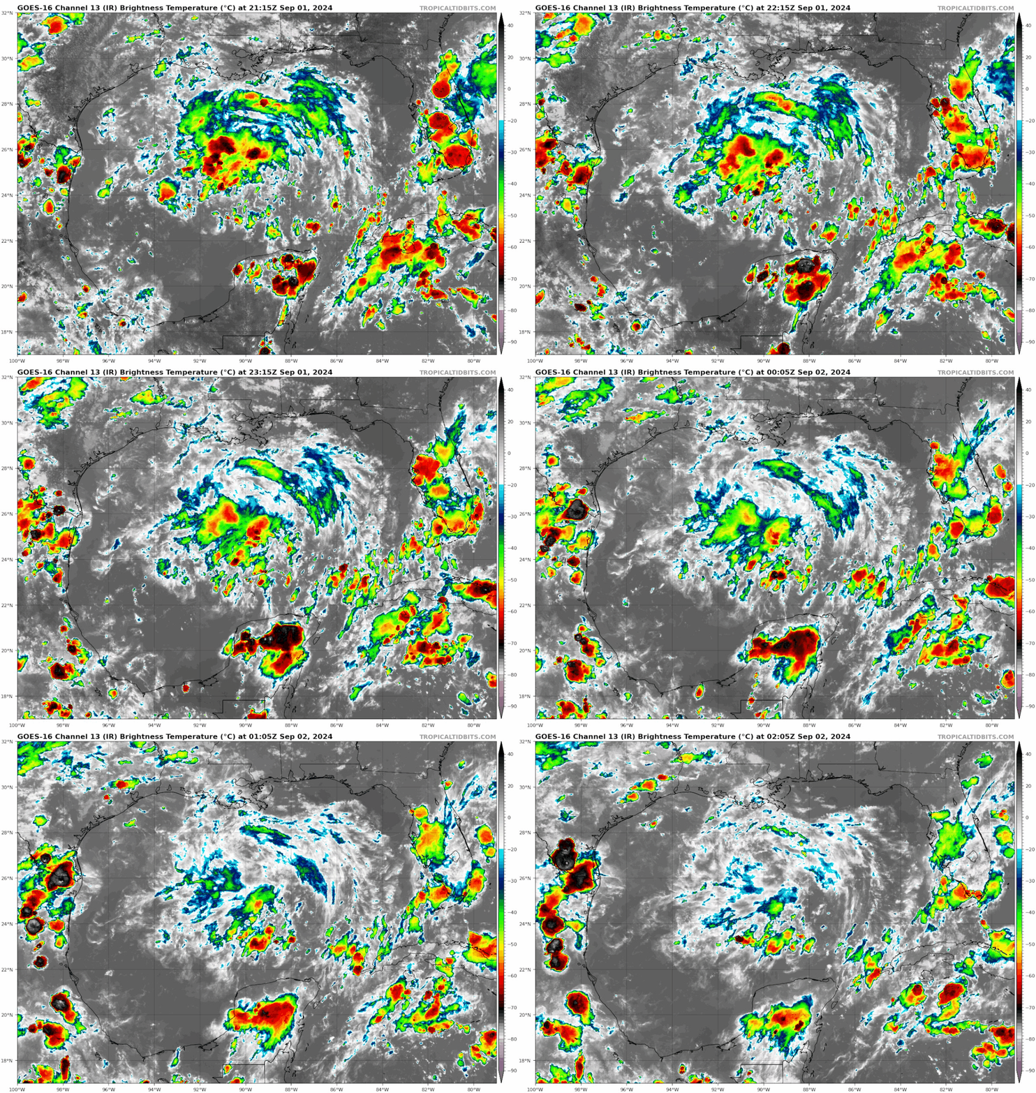
Area of disturbed weather in NW Gulf of Mexico (Is Invest 90L)

This is the general tropical discussion area. Anyone can take their shot at predicting a storms path.

Moderator: S2k Moderators

Forum rules

The posts in this forum are NOT official forecasts and should not be used as such. They are just the opinion of the poster and may or may not be backed by sound meteorological data. They are NOT endorsed by any professional institution or STORM2K. For official information, please refer to products from the National Hurricane Center and National Weather Service.

Help Support Storm2K
Message
Author
TomballEd
Category 2
Category 2
Posts: 686
Age: 61
Joined: Wed Aug 16, 2023 4:52 pm
Location: Spring/Klein area, not Tomball

Re: Area of disturbed weather in NW Gulf of Mexico (10/10)

#101 Postby TomballEd » Sun Sep 01, 2024 3:58 pm

Hammy wrote:
Stratton23 wrote:Hammy the NAM is utter garbage with tropical development, its really only useful for winter, temperature and that sort of stuff


This is very true, when we're talking the track, because it overdevelops storms--but it's extremely useful in knowing when something is (or rather, isn't) going to develop.

I've used and familiarized myself with it for over a decade now, and it's ALWAYS, without fail, picked up these close to home storms well before any of the models do--it has spun up things that don't form, but not once has it actually missed a storm--if something's going to form in the Gulf, it's always the first to show it.

Given how hypersensitive this model is, if even it isn't showing development, then there isn't likely going to be any, the same way the UKMET is a near-certainty when it actually does show development (given it has the opposite issue of frequently missing storms)


It might have been Humberto where the NAM, joined by the Canadian, at that time called 'The Crazy Uncle' (they have made improvements) were the first to see development.
1 likes   

User avatar
Hammy
Category 5
Category 5
Posts: 5849
Age: 41
Joined: Fri May 25, 2012 5:25 pm
Contact:

Re: Area of disturbed weather in NW Gulf of Mexico (10/10)

#102 Postby Hammy » Sun Sep 01, 2024 4:35 pm

TomballEd wrote:
Hammy wrote:
Stratton23 wrote:Hammy the NAM is utter garbage with tropical development, its really only useful for winter, temperature and that sort of stuff


This is very true, when we're talking the track, because it overdevelops storms--but it's extremely useful in knowing when something is (or rather, isn't) going to develop.

I've used and familiarized myself with it for over a decade now, and it's ALWAYS, without fail, picked up these close to home storms well before any of the models do--it has spun up things that don't form, but not once has it actually missed a storm--if something's going to form in the Gulf, it's always the first to show it.

Given how hypersensitive this model is, if even it isn't showing development, then there isn't likely going to be any, the same way the UKMET is a near-certainty when it actually does show development (given it has the opposite issue of frequently missing storms)


It might have been Humberto where the NAM, joined by the Canadian, at that time called 'The Crazy Uncle' (they have made improvements) were the first to see development.


Humberto, Emily in 2017, Gordon in 18, Imelda in 19, Bertha in 20, Mindy in 21 and Colin in 22 are among the ones I can name off the top of my head that it caught before the global models
2 likes   
The above post is not official and should not be used as such. It is the opinion of the poster and may or may not be backed by sound meteorological data. It is not endorsed by any professional institution or storm2k.org. For official information, please refer to the NHC and NWS products.

User avatar
Steve
S2K Supporter
S2K Supporter
Posts: 9620
Joined: Sat Apr 05, 2003 11:41 pm
Location: Not a state-caster

Re: Area of disturbed weather in NW Gulf of Mexico (10/10)

#103 Postby Steve » Sun Sep 01, 2024 4:43 pm

Hammy wrote:There's still way too much shear (an issue we've seen in the Gulf for weeks now)

The NAM isn't even showing development, and until it does this is DOA


It’s also on the edge of the Nam range as is usually seen by lows jumping around every hour or two on its runs. Nam is better north of 29.
0 likes   

User avatar
cycloneye
Admin
Admin
Posts: 145263
Age: 68
Joined: Thu Oct 10, 2002 10:54 am
Location: San Juan, Puerto Rico

Re: Area of disturbed weather in NW Gulf of Mexico (10/10)

#104 Postby cycloneye » Sun Sep 01, 2024 6:32 pm

Northwestern Gulf of Mexico:
A broad area of low pressure just offshore of the upper Texas coast
continues to produce some disorganized shower and thunderstorm
activity near the coasts of Texas and Louisiana and over the
adjacent waters of the northwestern Gulf of Mexico. This system is
expected to meander near the coast for the next couple of days, and
some slow development is possible if it remains offshore. By
Tuesday, the system is forecast to move inland, and further
development is not expected. Regardless, heavy rains could cause
some flash flooding across portions of coastal Louisiana and the
upper Texas coast during the next couple of days.
* Formation chance through 48 hours...low...10 percent.
* Formation chance through 7 days...low...10 percent.
0 likes   
Visit the Caribbean-Central America Weather Thread where you can find at first post web cams,radars
and observations from Caribbean basin members Click Here

User avatar
Teban54
Category 5
Category 5
Posts: 3204
Joined: Sat May 19, 2018 1:19 pm

Re: Area of disturbed weather in NW Gulf of Mexico (10/10)

#105 Postby Teban54 » Sun Sep 01, 2024 9:22 pm

Teban54 wrote:Here's the 3km NAM run for clarification purposes. Its current depictions are:

  • The convection we're seeing right now dies in a couple hours. This may imply they're partially shear-induced, even though associated with a mid-level vortex (as Frank mentioned above).
  • The current low-level vort just offshore Texas drifts SW towards Corpus Christi during the next 36 hours or so.
  • However, during the same time frame, the mid-level vort that's currently in central Gulf also gets better defined on its own, while remaining largely stationary. Another low-level vort shows up underneath it in the next 10 hours, but gets pushed to the W much faster than mid-level.
  • Beyond 36 hrs, the COC that's now a bit west of Corpus Christi does try to develop a mid-level rotation, but it's too late as the system is already inland.

https://i.postimg.cc/XqbvKMD0/nam3km-ir-eus-fh1-56.gif

The poof moment as forecast by 3km NAM indeed verified. While shear has certainly dropped, that may give further credence to the idea that some of the convection earlier may have been shear-induced.

Image
0 likes   

User avatar
Teban54
Category 5
Category 5
Posts: 3204
Joined: Sat May 19, 2018 1:19 pm

Re: Area of disturbed weather in NW Gulf of Mexico (10/10)

#106 Postby Teban54 » Mon Sep 02, 2024 1:31 am

Still at 10/10, and area of formation does not capture the MLC in the middle of the Gulf.

1. Northwestern Gulf of Mexico:
A broad area of low pressure just offshore of the upper Texas coast
continues to produce some disorganized shower activity near the
coast and over the adjacent waters of the northwestern Gulf of
Mexico. This system is expected to meander near the coast for the
next couple of days, and some slow development is possible if it
remains offshore. By Tuesday, the system is forecast to move inland,
and further development is not expected. Regardless, heavy rains
could cause some flash flooding across portions of the Texas coast
during the next couple of days.
* Formation chance through 48 hours...low...10 percent.
* Formation chance through 7 days...low...10 percent.
0 likes   

ChrisH-UK
Category 2
Category 2
Posts: 623
Joined: Sat May 29, 2021 8:22 am

Re: Area of disturbed weather in NW Gulf of Mexico (10/10)

#107 Postby ChrisH-UK » Mon Sep 02, 2024 3:39 am

Looks like its has moved south of New Orleans the low level rotation is still there but the shear is blowing away any convection and looks like it will remain like that for the next few days unless it moves west towards Texas and out of the shear.

Image
0 likes   

User avatar
Nimbus
Category 5
Category 5
Posts: 5300
Joined: Mon Jul 19, 2004 10:54 am

Re: Area of disturbed weather in NW Gulf of Mexico (10/10)

#108 Postby Nimbus » Mon Sep 02, 2024 5:45 am

The surface pressure at buoy 42002 lowered its cycle low to 29.78 inches.
That is where we usually start seeing persistent shower activity and more rapid development.
Forecast to move inland though so it would be just a rainmaker if the development scenario follows forecast.
1 likes   

User avatar
cycloneye
Admin
Admin
Posts: 145263
Age: 68
Joined: Thu Oct 10, 2002 10:54 am
Location: San Juan, Puerto Rico

Re: Area of disturbed weather in NW Gulf of Mexico (10/10)

#109 Postby cycloneye » Mon Sep 02, 2024 7:26 am

Northwestern Gulf of Mexico:
A broad and weak area of low pressure just offshore of the middle
Texas coast continues to produce some disorganized shower activity
along portions of the coast of Texas and over the adjacent waters of
the northwestern Gulf of Mexico. This system is expected to meander
for another day or so, and some slow development is possible if it
remains offshore. On Tuesday, the low is forecast to move inland,
and further development is not expected. Regardless, heavy rains
could cause some flash flooding across portions of the Texas coast
during the next couple of days.
* Formation chance through 48 hours...low...10 percent.
* Formation chance through 7 days...low...10 percent.
0 likes   
Visit the Caribbean-Central America Weather Thread where you can find at first post web cams,radars
and observations from Caribbean basin members Click Here

Nederlander
S2K Supporter
S2K Supporter
Posts: 1250
Joined: Sat Jul 19, 2008 4:28 pm
Location: Conroe, TX

Re: Area of disturbed weather in NW Gulf of Mexico (10/10)

#110 Postby Nederlander » Mon Sep 02, 2024 7:35 am

ChrisH-UK wrote:Looks like its has moved south of New Orleans the low level rotation is still there but the shear is blowing away any convection and looks like it will remain like that for the next few days unless it moves west towards Texas and out of the shear.

[url]https://imagizer.imageshack.com/img924/9572/UoNLay.gif [/url]


New Orleans? The low pressure area being discussed is offshore near the coastal bend area of Texas.
0 likes   

underthwx
Category 5
Category 5
Posts: 2360
Joined: Sat Jul 30, 2011 2:14 pm
Location: Brazoria County Texas

Re: Area of disturbed weather in NW Gulf of Mexico (10/10)

#111 Postby underthwx » Mon Sep 02, 2024 9:19 am

ChrisH-UK wrote:Looks like its has moved south of New Orleans the low level rotation is still there but the shear is blowing away any convection and looks like it will remain like that for the next few days unless it moves west towards Texas and out of the shear.

[url]https://imagizer.imageshack.com/img924/9572/UoNLay.gif [/url]

Or hopefully it will move inland as indicated by the NHC....before any development....the cloud cover is welcome tho....cooler temps...
0 likes   

underthwx
Category 5
Category 5
Posts: 2360
Joined: Sat Jul 30, 2011 2:14 pm
Location: Brazoria County Texas

Re: Area of disturbed weather in NW Gulf of Mexico (10/10)

#112 Postby underthwx » Mon Sep 02, 2024 9:26 am

Teban54 wrote:
Teban54 wrote:Here's the 3km NAM run for clarification purposes. Its current depictions are:

  • The convection we're seeing right now dies in a couple hours. This may imply they're partially shear-induced, even though associated with a mid-level vortex (as Frank mentioned above).
  • The current low-level vort just offshore Texas drifts SW towards Corpus Christi during the next 36 hours or so.
  • However, during the same time frame, the mid-level vort that's currently in central Gulf also gets better defined on its own, while remaining largely stationary. Another low-level vort shows up underneath it in the next 10 hours, but gets pushed to the W much faster than mid-level.
  • Beyond 36 hrs, the COC that's now a bit west of Corpus Christi does try to develop a mid-level rotation, but it's too late as the system is already inland.

https://i.postimg.cc/XqbvKMD0/nam3km-ir-eus-fh1-56.gif

The poof moment as forecast by 3km NAM indeed verified. While shear has certainly dropped, that may give further credence to the idea that some of the convection earlier may have been shear-induced.

https://i.postimg.cc/25YBYKDy/goes16-ir-gom.gif

Teban....is shear what is keeping this broad low from developing?....
0 likes   

ChrisH-UK
Category 2
Category 2
Posts: 623
Joined: Sat May 29, 2021 8:22 am

Re: Area of disturbed weather in NW Gulf of Mexico (10/10)

#113 Postby ChrisH-UK » Mon Sep 02, 2024 9:39 am

Nederlander wrote:
ChrisH-UK wrote:Looks like its has moved south of New Orleans the low level rotation is still there but the shear is blowing away any convection and looks like it will remain like that for the next few days unless it moves west towards Texas and out of the shear.

[url]https://imagizer.imageshack.com/img924/9572/UoNLay.gif [/url]


New Orleans? The low pressure area being discussed is offshore near the coastal bend area of Texas.


Well to me they looks to be 2 low pressure areas one off the coast and one south of the mississippi delta, the latest gfs run seems to explain it with one coming on land and the second one spinning up and coming in behind it.

Here's the GFS 850 vorticity

Image

And now the sun is up we can better see what is going on.

Image
1 likes   

crimi481
Category 2
Category 2
Posts: 602
Joined: Thu Sep 09, 2004 4:47 pm

Re: Area of disturbed weather in NW Gulf of Mexico (10/10)

#114 Postby crimi481 » Mon Sep 02, 2024 9:54 am

I will place my wager on the central Gulf system becoming a named storm in time
0 likes   

TomballEd
Category 2
Category 2
Posts: 686
Age: 61
Joined: Wed Aug 16, 2023 4:52 pm
Location: Spring/Klein area, not Tomball

Re: Area of disturbed weather in NW Gulf of Mexico (10/10)

#115 Postby TomballEd » Mon Sep 02, 2024 10:24 am

I'll place my bet of Monopoly money there will be no name. There is low level vorticity off the lower Texas coast, but there is no mid level reflection

A non-tropical low with convection nearly stationary over the Gulf in late August into September would almost certainly try to spin up in a normal year. Something is very different about this year. (There is another thread). April like static stability, for whatever reason, is probably a direct cause.
0 likes   

Frank P
S2K Supporter
S2K Supporter
Posts: 2774
Joined: Fri Aug 29, 2003 10:52 am
Location: Biloxi Beach, Ms
Contact:

Re: Area of disturbed weather in NW Gulf of Mexico (10/10)

#116 Postby Frank P » Mon Sep 02, 2024 12:31 pm

Any other year I would place money on that sat image developing in the GOM, and if you were to show me this image before August 10th, I would have placed big money, especially in the year that was forecast to be extremely active. But since Ernesto nothing has been able to spin up anywhere: nada, zip, zero, niente. Strange times indeed mama... I am leaning towards nothing legit being named out of either of these systems...
1 likes   

Stormcenter
S2K Supporter
S2K Supporter
Posts: 6683
Joined: Wed Sep 03, 2003 11:27 am
Location: Houston, TX

Re: Area of disturbed weather in NW Gulf of Mexico (10/10)

#117 Postby Stormcenter » Mon Sep 02, 2024 12:37 pm

TomballEd wrote:I'll place my bet of Monopoly money there will be no name. There is low level vorticity off the lower Texas coast, but there is no mid level reflection


Yes this is very true…..no doubt any other season we’d
have a developing storm in the GOM right now.


A non-tropical low with convection nearly stationary over the Gulf in late August into September would almost certainly try to spin up in a normal year. Something is very different about this year. (There is another thread). April like static stability, for whatever reason, is probably a direct cause.
0 likes   

Stormcenter
S2K Supporter
S2K Supporter
Posts: 6683
Joined: Wed Sep 03, 2003 11:27 am
Location: Houston, TX

Re: Area of disturbed weather in NW Gulf of Mexico (10/10)

#118 Postby Stormcenter » Mon Sep 02, 2024 12:38 pm

Exactly!!!!

Frank P wrote:Any other year I would place money on that sat image developing in the GOM, and if you were to show me this image before August 10th, I would have placed big money, especially in the year that was forecast to be extremely active. But since Ernesto nothing has been able to spin up anywhere: nada, zip, zero, niente. Strange times indeed mama... I am leaning towards nothing legit being named out of either of these systems...
0 likes   

User avatar
Teban54
Category 5
Category 5
Posts: 3204
Joined: Sat May 19, 2018 1:19 pm

Re: Area of disturbed weather in NW Gulf of Mexico (10/10)

#119 Postby Teban54 » Mon Sep 02, 2024 12:49 pm

I mean, isn't part of the problem that the low-level center is simply too close to the coast? I'm not sure if I'd attribute everything about this to issues with the season.

(For anyone looking at the mid-level rotation in the central GoM, it probably would have had a much easier time working down to the surface if the low-level vort offshore Texas wasn't already in place.)
0 likes   

User avatar
cycloneye
Admin
Admin
Posts: 145263
Age: 68
Joined: Thu Oct 10, 2002 10:54 am
Location: San Juan, Puerto Rico

Re: Area of disturbed weather in NW Gulf of Mexico (0/0)

#120 Postby cycloneye » Mon Sep 02, 2024 1:20 pm

Northwestern Gulf of Mexico:
A broad and weak area of low pressure just offshore of the middle
Texas coast continues to produce some disorganized shower activity
along portions of the coast of Texas and over the adjacent waters of
the northwestern Gulf of Mexico. This system is expected to move
inland early Tuesday, and development is not expected. Regardless,
heavy rains could cause some flash flooding across portions of the
Texas coast during the next day or two.
* Formation chance through 48 hours...low...near 0 percent.
* Formation chance through 7 days...low...near 0 percent.
0 likes   
Visit the Caribbean-Central America Weather Thread where you can find at first post web cams,radars
and observations from Caribbean basin members Click Here


Return to “Talkin' Tropics”

Who is online

Users browsing this forum: Ulf and 12 guests