Possible GOM/Caribbean development

This is the general tropical discussion area. Anyone can take their shot at predicting a storms path.

Moderator: S2k Moderators

Forum rules

The posts in this forum are NOT official forecasts and should not be used as such. They are just the opinion of the poster and may or may not be backed by sound meteorological data. They are NOT endorsed by any professional institution or STORM2K. For official information, please refer to products from the National Hurricane Center and National Weather Service.

Help Support Storm2K
Message
Author
User avatar
HURAKAN
Professional-Met
Professional-Met
Posts: 46086
Age: 38
Joined: Thu May 20, 2004 4:34 pm
Location: Key West, FL
Contact:

#101 Postby HURAKAN » Tue Jun 01, 2010 7:55 am

Image

Loop
0 likes   

User avatar
Blown Away
S2K Supporter
S2K Supporter
Posts: 10152
Joined: Wed May 26, 2004 6:17 am

Re: Possible GOM/Caribbean development

#102 Postby Blown Away » Tue Jun 01, 2010 8:54 am

Image

Making a comeback!!
0 likes   
Hurricane Eye Experience: David 79, Irene 99, Frances 04, Jeanne 04, Wilma 05... EYE COMING MY WAY IN 2024…
Hurricane Brush Experience: Andrew 92, Erin 95, Floyd 99, Matthew 16, Irma 17, Ian 22, Nicole 22…

User avatar
KWT
Category 5
Category 5
Posts: 31415
Joined: Tue Aug 17, 2004 11:02 am
Location: UK!!!

#103 Postby KWT » Tue Jun 01, 2010 9:01 am

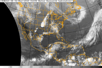
Looking at the IR the system really is right on the edge of the higher shear, you can see little convective cells getting sheared to pieces just 75-150 miles further of the system so the system has got to stay exactly where it is.

If we can keep this system going a little while longer then we could well get an invest out of this.
0 likes   
Personal Forecast Disclaimer:
The posts in this forum are NOT official forecast and should not be used as such. They are just the opinion of the poster and may or may not be backed by sound meteorological data. They are NOT endorsed by any professional institution or storm2k.org. For official information, please refer to the NHC and NWS products

User avatar
Cdeck81
Tropical Low
Tropical Low
Posts: 20
Age: 28
Joined: Sat May 29, 2010 9:40 pm
Location: Beaumont, TX

Re: Possible GOM/Caribbean development

#104 Postby Cdeck81 » Tue Jun 01, 2010 9:55 am

I don't see this becoming anything...
0 likes   

User avatar
HURAKAN
Professional-Met
Professional-Met
Posts: 46086
Age: 38
Joined: Thu May 20, 2004 4:34 pm
Location: Key West, FL
Contact:

#105 Postby HURAKAN » Tue Jun 01, 2010 10:05 am

Image

Vorticity now over water
0 likes   

tolakram
Admin
Admin
Posts: 20012
Age: 62
Joined: Sun Aug 27, 2006 8:23 pm
Location: Florence, KY (name is Mark)

Re: Possible GOM/Caribbean development

#106 Postby tolakram » Tue Jun 01, 2010 10:10 am

Visible 15 minute frames

http://wwwghcc.msfc.nasa.gov/cgi-bin/ge ... mframes=15

Looks like one tower left and numerous outflow boundaries.

What's most striking, to me, is the vigorous inflow coming from the SE. Notice how it's flowing directly into the blob while everything else is moving generally east to west.
0 likes   
M a r k
- - - - -
Join us in chat: Storm2K Chatroom Invite. Android and IOS apps also available.

The posts in this forum are NOT official forecasts and should not be used as such. Posts are NOT endorsed by any professional institution or STORM2K.org. For official information and forecasts, please refer to NHC and NWS products.

User avatar
KWT
Category 5
Category 5
Posts: 31415
Joined: Tue Aug 17, 2004 11:02 am
Location: UK!!!

#107 Postby KWT » Tue Jun 01, 2010 10:14 am

Yeah that loop there shows what your saying there very nicely, also the northern part of the convection is getting very nicely fanned out to the ENE by the jet streak to the north.

Looks like its holding steady for now anyway.
0 likes   
Personal Forecast Disclaimer:
The posts in this forum are NOT official forecast and should not be used as such. They are just the opinion of the poster and may or may not be backed by sound meteorological data. They are NOT endorsed by any professional institution or storm2k.org. For official information, please refer to the NHC and NWS products

User avatar
NDG
S2K Supporter
S2K Supporter
Posts: 15446
Joined: Sun Jul 09, 2006 10:14 pm
Location: Orlando, FL

Re: Possible GOM/Caribbean development

#108 Postby NDG » Tue Jun 01, 2010 10:15 am

I am still able to see the very weak circulation that was present yesterday just east of Belize.
Surface pressures have not fallen, if anything they are a little higher than yesterday. I guess convection has not died off yet because there's still a nice inflow into those storms from the SE.

Image
0 likes   

User avatar
robbielyn
Category 5
Category 5
Posts: 1298
Joined: Wed May 07, 2003 9:45 am
Location: brooksville, fl

#109 Postby robbielyn » Tue Jun 01, 2010 10:58 am

JB says cant develop d/t shear north of its present location being too strong wont make ts again however bring heavy rains to south fl.
0 likes   
Robbielyn McCrary
I know just about enough to sound like I know what I'm talking about sometimes. But for your safety please follow the nhc for truly professional forecasting. :D

User avatar
cycloneye
Admin
Admin
Posts: 145568
Age: 68
Joined: Thu Oct 10, 2002 10:54 am
Location: San Juan, Puerto Rico

Re: Possible GOM/Caribbean development

#110 Postby cycloneye » Tue Jun 01, 2010 12:08 pm

Is invest 91L so the thread is locked. Go to Active Storms forum to continue the discussions.

viewtopic.php?f=59&t=108104&p=1986794#p1986794
0 likes   
Visit the Caribbean-Central America Weather Thread where you can find at first post web cams,radars
and observations from Caribbean basin members Click Here


Return to “Talkin' Tropics”

Who is online

Users browsing this forum: Cpv17, IsabelaWeather, Killjoy12, ljmac75 and 67 guests