Personal Forecast Discussion of 04L (DENNIS)..Reposted

This is the general tropical discussion area. Anyone can take their shot at predicting a storms path.

Moderator: S2k Moderators

Forum rules

The posts in this forum are NOT official forecasts and should not be used as such. They are just the opinion of the poster and may or may not be backed by sound meteorological data. They are NOT endorsed by any professional institution or STORM2K. For official information, please refer to products from the National Hurricane Center and National Weather Service.

Help Support Storm2K
Message
Author
DoctorHurricane2003

Personal Forecast Discussion of 04L (DENNIS)..Reposted

#1 Postby DoctorHurricane2003 » Thu Jul 07, 2005 12:09 am

S2K DISCLAIMER: The following post is NOT an official forecast and should not be used as such. It is just the opinion of the poster and may or may not be backed by sound meteorological data. It is NOT endorsed by any professional institution including storm2k.org For Official Information please refer to the NHC and NWS products.

PERSONAL DISCLAIMER: For all official information, please visit the National Hurricane Center website at http://www.nhc.noaa.gov/ . For all local information, including information on evacuations and preparedness, please go to http://www.srh.noaa.gov/ and follow the link to your appropriate location.

GRAPHIC DISCLAIMER: The graphic is for visualization purposes only and is NOT endorsed by S2K, NHC, or NOAA.

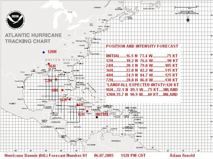
WED 06.07.2005 1154 PM CDT

Dennis has become much better organized throughout the day today and is currently a category 1 hurricane on the saffir-simpson scale. Dennis is moving toward the WNW, and slowing down a bit. Current intensification trends could lead to a rapid development phase quite soon, and Dennis could become a major hurricane tomorrow. I expect Dennis will continue to intensify and reach strong category 4 strength in the Gulf of Mexico, where he may begin eyewall replacement cycles and/or start to feel some light southwesterly shear (the result of this is noted in the graphic as a landfall intensity of 120 KT). Current track trends have changed little, and am currently forecasting a brush of Jamaica to the north, a strike in western Cuba, and a landfall along the N Central Gulf Coast Sun-Mon. Dennis is a large storm and it is noted that effects will spread away from the center at great distances. Please stay tuned to your local television or radio station for updates on evacuations and hurricane preparedness tips. ALL residents along the Gulf Coast need to monitor the track of Dennis very closely.

Image


Reposted as photobucket was using old graphic.
0 likes   

User avatar
Hurricaneman
Category 5
Category 5
Posts: 7404
Age: 45
Joined: Tue Aug 31, 2004 3:24 pm
Location: central florida

#2 Postby Hurricaneman » Thu Jul 07, 2005 12:10 am

That would be a borderline cat4/5
0 likes   

Droop12
Category 1
Category 1
Posts: 377
Joined: Thu Oct 07, 2004 9:57 pm
Location: Indianapolis

#3 Postby Droop12 » Thu Jul 07, 2005 12:14 am

Good work Doc, love the map its very well done. Unfourtanetly, looks like our area could be in for it. Keep up the good work though.
0 likes   


Return to “Talkin' Tropics”

Who is online

Users browsing this forum: AnnularCane, wwizard and 563 guests