

I decided to compile some links related to monitoring and predicting the MJO so that everyone can follow it on their own.
First, The CDC (Climate Diagnostics center) has a GREAT page dedicated to experimental MJO predictions. Links below:
Links to experimental MJO predictions (courtesy of the CDC):
http://www.cdc.noaa.gov/map/images/mjo/index.html
http://www.cdc.noaa.gov/map/images/mjo/ ... otals.html
http://www.cdc.noaa.gov/map/images/mjo/index.html
http://www.cdc.noaa.gov/map/images/mjo/ ... anoms.html
http://www.cdc.noaa.gov/map/images/mjo/index_hovs.html
MJO discussions:
http://www.cdc.noaa.gov/map/images/mjo/ ... sions.html
Monitoring the MJO:
Time-Longitude sections:
850mb zonal wind:
http://www.cpc.ncep.noaa.gov/products/i ... _tlon.html
200H velocity potential:
http://www.cpc.ncep.noaa.gov/products/i ... _tlon.html
OLR anomalies (Outgoing Longwave Radiation):
http://www.cpc.ncep.noaa.gov/products/i ... loneq.html
5-day Averages:
500mb height anomalies
http://www.cpc.ncep.noaa.gov/products/i ... ights.html
200mb height/wind:
http://www.cpc.ncep.noaa.gov/products/i ... winds.html
Assorted Animations:
http://www.cpc.ncep.noaa.gov/products/i ... 0anim.html
http://www.cpc.ncep.noaa.gov/products/p ... nthly.html
Eastern hemisphere:
http://www.cpc.ncep.noaa.gov/products/p ... ic_eh.html
Western Hemisphere:
http://www.cpc.ncep.noaa.gov/products/p ... optic.html
5-day and 15-day running mean:
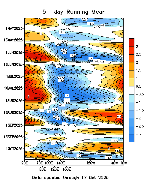
5-day:
http://www.cpc.ncep.noaa.gov/products/p ... _order.gif
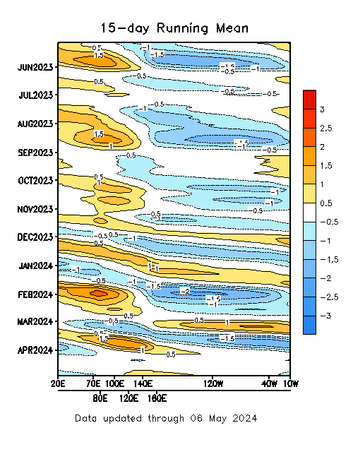
15-day:
http://www.cpc.ncep.noaa.gov/products/p ... _order.gif
MJO impacts:
http://www.cpc.ncep.noaa.gov/products/p ... tails.html
MJO archives 1978-current:
http://www.cpc.ncep.noaa.gov/products/p ... entad.html
ENJOY.
Easy Access MJO links for everyone.
Moderator: S2k Moderators
Forum rules

The posts in this forum are NOT official forecasts and should not be used as such. They are just the opinion of the poster and may or may not be backed by sound meteorological data. They are NOT endorsed by any professional institution or STORM2K. For official information, please refer to products from the National Hurricane Center and National Weather Service.


-
cycloneye

- Admin

- Posts: 148791
- Age: 69
- Joined: Thu Oct 10, 2002 10:54 am
- Location: San Juan, Puerto Rico
http://www.cpc.ncep.noaa.gov/products/p ... nthly.html
The latest data shows that in the atlantic the dry phase of MJO is on full status and you can see how inactive it is meanwhile hurricane Darby formed with a wet phase of MJO see the diference? But when mid august arrives also the wet phase of MJO will spill into the atlantic meaning favorable enviroment when the heart of the season comes.
The latest data shows that in the atlantic the dry phase of MJO is on full status and you can see how inactive it is meanwhile hurricane Darby formed with a wet phase of MJO see the diference? But when mid august arrives also the wet phase of MJO will spill into the atlantic meaning favorable enviroment when the heart of the season comes.
0 likes
Visit the Caribbean-Central America Weather Thread where you can find at first post web cams,radars
and observations from Caribbean basin members Click Here
and observations from Caribbean basin members Click Here
Who is online
Users browsing this forum: MarioProtVI, Steve and 131 guests