170 knots based off FL reductions in the weaker quad and TDR data suggesting winds up to 15 knots stronger in the northeast.
~891 mbar works as peak pressure at 12z given it was 892 and rising shortly thereafter.
How strong was Hurricane Melissa 2025?
Moderator: S2k Moderators
Forum rules

The posts in this forum are NOT official forecasts and should not be used as such. They are just the opinion of the poster and may or may not be backed by sound meteorological data. They are NOT endorsed by any professional institution or STORM2K. For official information, please refer to products from the National Hurricane Center and National Weather Service.
-
Yellow Evan

- Professional-Met

- Posts: 16200
- Age: 27
- Joined: Fri Jul 15, 2011 12:48 pm
- Location: Henderson, Nevada/Honolulu, HI
- Contact:

Re: How strong was Hurricane Melissa 2025?
The wind damage I've seen from Melissa '25 is absolutely jaw-dropping. No question this is some of the worst wind-damage from an Atlantic landfall since 1935, definitely a high-end Cat 5 with winds over 175 mph.
Just unreal, images from various posts on X.


Just unreal, images from various posts on X.
2 likes
Georges '98, Irene '99, Frances '04, Jeanne '04, Katrina '05, Wilma '05, Gustav '08, Isaac '12, Matthew '16, Florence '18, Michael '18, Ian '22
-
Easterlywave

- Tropical Wave

- Posts: 3
- Age: 78
- Joined: Wed Oct 29, 2025 11:55 am
- Contact:
Re: How strong was Hurricane Melissa 2025?
FireRat wrote:The wind damage I've seen from Melissa '25 is absolutely jaw-dropping. No question this is some of the worst wind-damage from an Atlantic landfall since 1935, definitely a high-end Cat 5 with winds over 175 mph.
Just unreal, images from various posts on X.
https://i.ibb.co/k25RxL14/G5-ICQ0-WW8-AA4fj-G.jpg
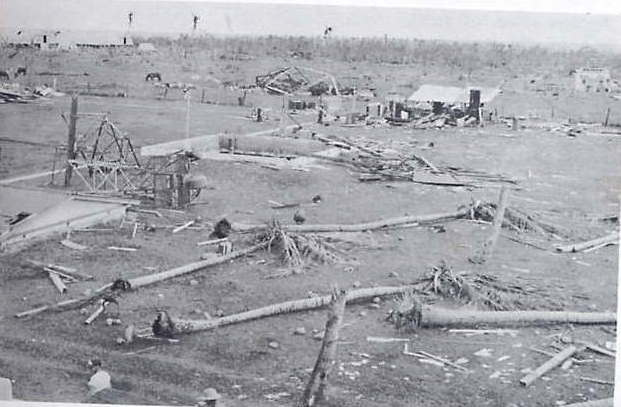
Those images from Jamaica look like Hiroshima after atom bomb was dropped in1945. Also reminds me of reports of Hurricane Janet, 1955, where at least 175 mph winds (the anemometer blew away at that point) tore Chetumel, Mx apart. Janet flattened Swan Island shortly before that. The only recon. plane to be lost in the Atlantic happened in the W. Carib. and 914 pressure was recorded at one point. Below is Swan Island,
3 likes
A Pioneer of hurricane chasing: 1966---> Created the 1st. hurricane and storm chasing business ever: 1982. https://www.canebeard.com/hurricane_chaser.html
Re: How strong was Hurricane Melissa 2025?
Easterlywave wrote:FireRat wrote:The wind damage I've seen from Melissa '25 is absolutely jaw-dropping. No question this is some of the worst wind-damage from an Atlantic landfall since 1935, definitely a high-end Cat 5 with winds over 175 mph.
Just unreal, images from various posts on X.
https://i.ibb.co/k25RxL14/G5-ICQ0-WW8-AA4fj-G.jpg
Those images from Jamaica look like Hiroshima after atom bomb was dropped in1945. Also reminds me of reports of Hurricane Janet, 1955, where at least 175 mph winds (the anemometer blew away at that point) tore Chetumel, Mx apart. Janet flattened Swan Island shortly before that. The only recon. plane to be lost in the Atlantic happened in the W. Carib. and 914 pressure was recorded at one point. Below is Swan Island,
[url]https://i.postimg.cc/KzVHb5R8/swan-island.jpg [/url]
Wow! Janet was a beast!! Never seen such extreme damage from that storm before, certainly up there with the strongest landfalls of all time. Swan Island got flattened! Truly sad about that recon plane, nasty hurricane.
0 likes
Georges '98, Irene '99, Frances '04, Jeanne '04, Katrina '05, Wilma '05, Gustav '08, Isaac '12, Matthew '16, Florence '18, Michael '18, Ian '22

Re: How strong was Hurricane Melissa 2025?
Josh has released his long-awaited Hurricane Melissa report. One of his barometers recorded a minimum pressure of 926.0mb at 17:20z, placed at 18.0438N 77.9105W. His other three barometers bottomed out at 927.1-927.3mb.
https://static1.squarespace.com/static/ ... SA2025.pdf
Since recon provided us with the pressure gradient ahead of landfall, it shouldn’t be too difficult to work backwards towards the center using Josh’s measurement and determine the minimum landfall pressure. Since I don’t have that pressure gradient data, for now I’ve focused on obtaining more precise estimates of Melissa’s position and distance from Josh’s barometer. I used Google Maps with his most zoomed-in map as reference, but I may still be a few hundredths of a degree off with my estimates. This is what I get:
—17:00z: Melissa at 18.1000N/77.9968W, 5.95 nmi from Kestrel Meter No 936.
—17:20z: Melissa at 18.1331N/77.9968W, 7.18 nmi from Kestrel Meter No 936.
2 likes
Irene '11 Sandy '12 Hermine '16 5/15/2018 Derecho Fay '20 Isaias '20 Elsa '21 Henri '21 Ida '21
I am only a meteorology enthusiast who knows a decent amount about tropical cyclones. Look to the professional mets, the NHC, or your local weather office for the best information.
I am only a meteorology enthusiast who knows a decent amount about tropical cyclones. Look to the professional mets, the NHC, or your local weather office for the best information.
-
MarioProtVI
- Category 5

- Posts: 1028
- Age: 24
- Joined: Sun Sep 29, 2019 7:33 pm
- Location: New Jersey
Re: How strong was Hurricane Melissa 2025?
aspen wrote:Josh has released his long-awaited Hurricane Melissa report. One of his barometers recorded a minimum pressure of 926.0mb at 17:20z, placed at 18.0438N 77.9105W. His other three barometers bottomed out at 927.1-927.3mb.
https://static1.squarespace.com/static/ ... SA2025.pdf
Since recon provided us with the pressure gradient ahead of landfall, it shouldn’t be too difficult to work backwards towards the center using Josh’s measurement and determine the minimum landfall pressure. Since I don’t have that pressure gradient data, for now I’ve focused on obtaining more precise estimates of Melissa’s position and distance from Josh’s barometer. I used Google Maps with his most zoomed-in map as reference, but I may still be a few hundredths of a degree off with my estimates. This is what I get:
—17:00z: Melissa at 18.1000N/77.9968W, 5.95 nmi from Kestrel Meter No 936.
—17:20z: Melissa at 18.1331N/77.9968W, 7.18 nmi from Kestrel Meter No 936.
Using calculations, this gives out an estimated pressure of 905.8 mb. Given this, it definitely seems to confirm Melissa weakened some before landfall. Using this, and checking with CKZ, I would peg the landfall intensity at 150 kt / 906 mb. Lets see if NHC goes with this, as they have used Josh’s analysis many times before.
1 likes
Re: How strong was Hurricane Melissa 2025?
MarioProtVI wrote:aspen wrote:Josh has released his long-awaited Hurricane Melissa report. One of his barometers recorded a minimum pressure of 926.0mb at 17:20z, placed at 18.0438N 77.9105W. His other three barometers bottomed out at 927.1-927.3mb.
https://static1.squarespace.com/static/ ... SA2025.pdf
Since recon provided us with the pressure gradient ahead of landfall, it shouldn’t be too difficult to work backwards towards the center using Josh’s measurement and determine the minimum landfall pressure. Since I don’t have that pressure gradient data, for now I’ve focused on obtaining more precise estimates of Melissa’s position and distance from Josh’s barometer. I used Google Maps with his most zoomed-in map as reference, but I may still be a few hundredths of a degree off with my estimates. This is what I get:
—17:00z: Melissa at 18.1000N/77.9968W, 5.95 nmi from Kestrel Meter No 936.
—17:20z: Melissa at 18.1331N/77.9968W, 7.18 nmi from Kestrel Meter No 936.
Using calculations, this gives out an estimated pressure of 905.8 mb. Given this, it definitely seems to confirm Melissa weakened some before landfall. Using this, and checking with CKZ, I would peg the landfall intensity at 150 kt / 906 mb. Lets see if NHC goes with this, as they have used Josh’s analysis many times before.
That would be a 3-4 mb/hr filling rate if that holds up. A little higher than I would’ve expected, even with the warming convection in the inner CDO. The eye still maintained a good structure up to 1 hr before landfall.
I went back to the recon thread to see if I could compare Josh’s measurement with anything from AF or NOAA. The latter had the most consistent extrapolated measurements during its NW eyewall penetration. Using the data points at 13:44:30z (comparable pressure to Josh’s observations) and 13:46:30z (lowest FL winds, likely center), I got a pressure difference of 32.6mb (927.7mb to 895.1mb) across a distance of 0.086 degrees. At 17:00z, Josh was 0.103 degrees SE of Melissa’s center. So this might still support a sub-900 landfall if this comparison is adequate. What were the calculations you used to yield 905.8mb?
0 likes
Irene '11 Sandy '12 Hermine '16 5/15/2018 Derecho Fay '20 Isaias '20 Elsa '21 Henri '21 Ida '21
I am only a meteorology enthusiast who knows a decent amount about tropical cyclones. Look to the professional mets, the NHC, or your local weather office for the best information.
I am only a meteorology enthusiast who knows a decent amount about tropical cyclones. Look to the professional mets, the NHC, or your local weather office for the best information.
-
MarioProtVI
- Category 5
- Posts: 1028
- Age: 24
- Joined: Sun Sep 29, 2019 7:33 pm
- Location: New Jersey
Re: How strong was Hurricane Melissa 2025?
aspen wrote:MarioProtVI wrote:aspen wrote:Josh has released his long-awaited Hurricane Melissa report. One of his barometers recorded a minimum pressure of 926.0mb at 17:20z, placed at 18.0438N 77.9105W. His other three barometers bottomed out at 927.1-927.3mb.
https://static1.squarespace.com/static/ ... SA2025.pdf
Since recon provided us with the pressure gradient ahead of landfall, it shouldn’t be too difficult to work backwards towards the center using Josh’s measurement and determine the minimum landfall pressure. Since I don’t have that pressure gradient data, for now I’ve focused on obtaining more precise estimates of Melissa’s position and distance from Josh’s barometer. I used Google Maps with his most zoomed-in map as reference, but I may still be a few hundredths of a degree off with my estimates. This is what I get:
—17:00z: Melissa at 18.1000N/77.9968W, 5.95 nmi from Kestrel Meter No 936.
—17:20z: Melissa at 18.1331N/77.9968W, 7.18 nmi from Kestrel Meter No 936.
Using calculations, this gives out an estimated pressure of 905.8 mb. Given this, it definitely seems to confirm Melissa weakened some before landfall. Using this, and checking with CKZ, I would peg the landfall intensity at 150 kt / 906 mb. Lets see if NHC goes with this, as they have used Josh’s analysis many times before.
That would be a 3-4 mb/hr filling rate if that holds up. A little higher than I would’ve expected, even with the warming convection in the inner CDO. The eye still maintained a good structure up to 1 hr before landfall.
I went back to the recon thread to see if I could compare Josh’s measurement with anything from AF or NOAA. The latter had the most consistent extrapolated measurements during its NW eyewall penetration. Using the data points at 13:44:30z (comparable pressure to Josh’s observations) and 13:46:30z (lowest FL winds, likely center), I got a pressure difference of 32.6mb (927.7mb to 895.1mb) across a distance of 0.086 degrees. At 17:00z, Josh was 0.103 degrees SE of Melissa’s center. So this might still support a sub-900 landfall if this comparison is adequate. What were the calculations you used to yield 905.8mb?
926.0 mb, 5 mi distance, 8 nmi RMW, 1006 mb ROCI. Though I calculated that before Josh replied to someone saying the RMW was most likely 5 nmi. However I don’t believe 5 nmi works because that gives out 891 which is not representative at all. Hence, I think the true RMW was most likely 6 nmi, of which that gives out 899.8 or ~900 mb for a landfall. The monkey wrenc seems to be how much was this following the only trend we saw before landfall, as we only had two fixes, that being 892 at 1302z and 894 at 1346z, which suggests ~3 mb/hr filling rate until landfall at 17z, which would be around roughly ~903 mb. It really sucks that we couldn’t get constant recon up until just before landfall so we’d have a better grasp on how much it filled into landfall, given NHC only kept 160 kt/892 mb at landfall for continuity purposes it seems (which is fine, just makes the post analysis a headache).
3 likes
Who is online
Users browsing this forum: CrazyC83, pepecool20 and 47 guests