2024 Indicators: SST's, MSLP, Shear, SAL, Steering, Instability (Day 16+ Climate Models)

This is the general tropical discussion area. Anyone can take their shot at predicting a storms path.

Moderator: S2k Moderators

Forum rules

The posts in this forum are NOT official forecasts and should not be used as such. They are just the opinion of the poster and may or may not be backed by sound meteorological data. They are NOT endorsed by any professional institution or STORM2K. For official information, please refer to products from the National Hurricane Center and National Weather Service.

Help Support Storm2K
Message
Author
zzzh
Category 2
Category 2
Posts: 553
Joined: Thu Sep 02, 2021 1:13 pm

Re: RE: Re: 2024 Indicators: SST's, MSLP, Shear, SAL, Steering, Instability (Day 16+ Climate Models)

#1021 Postby zzzh » Mon May 20, 2024 2:35 pm

DorkyMcDorkface wrote:
Woofde wrote:
zzzh wrote:https://i.imgur.com/InQdSJI.gif
I'd recommend against using that product. It included regions like south America and Africa in there, which can't represent the shear magnitude in the MDR.
Is there another similar product that doesn't have such biases?

Wondering about this too. Would be nice. If my coding skills weren't so rudimentary (and if I simply weren't so lazy) I probably could throw something together.

I can help with the code if you need :D
The problem with my end is that the ERA5 dataset size is too big for my computer to handle it, I can only plot the shear for 2024 but without a climatology line.
1 likes   

User avatar
weeniepatrol
Category 3
Category 3
Posts: 868
Joined: Sat Aug 22, 2020 5:30 pm
Location: WA State

Re: 2024 Indicators: SST's, MSLP, Shear, SAL, Steering, Instability (Day 16+ Climate Models)

#1022 Postby weeniepatrol » Mon May 20, 2024 3:48 pm

From today's weekly CPC MJO update:

Image
1 likes   

User avatar
Woofde
Category 1
Category 1
Posts: 289
Joined: Tue Jul 06, 2021 11:33 am

Re: 2024 Indicators: SST's, MSLP, Shear, SAL, Steering, Instability (Day 16+ Climate Models)

#1023 Postby Woofde » Tue May 21, 2024 1:10 am

skyline385 wrote:
Woofde wrote:
skyline385 wrote:
The plot here is for OHC though not SST. OHCs don't directly influence TCG or RI but can be a factor where too much OHC reduces the effect of upwelling and hence reducing the effect of upwelling for slow moving systems.

OHC is especially important for stronger systems right? If I remember correctly, they interact much deeper in the water column than weaker systems. I would imagine it increases the potential top end of the intensity spectrum.


There isn't any special interaction with deeper waters, its all about how much water is being upwelled. Stronger systems have stronger winds and upwell more water but if they are moving fast, its not much of a factor. Lee travelled over modest OHC (60-80 KJ/sq.cm) and still explosively blew up to a C5 (third fastest to get to C5 in the NATL). Dorian is an example on the other spectrum where it pretty much stalled and the OHC helped sustain it but again that was because it stalled. It also depends on the size of the system, Dorian was a small system with a small radius of the most extreme winds so that also played into how much water was being upwelled. Remember Dorian did gradually start to weaken once it stalled over the Bahamas as the OHC was being depleted. It was also pretty much parked over the Gulf stream so that played a factor in sustaining it as well. Any system moving at a decent pace generally can work with even the most modest OHC as long as other conditions are favourable.

Image
I totally agree about the upwelling part being important, but cyclones also don't just interact with the surface of the water. I found the article I was reading earlier. The idea is that a stronger storm is going to be pulling heat from deeper waters, leading to more latent heat release. I tend to think of upwelling as a specific case where a storm has been sitting on an area long enough to exhaust heat from an area. That's definitely an area, as you said where OHC is critical.

I was more referring to the case where a storm is moving at a solid pace, even then two patches of identical SSTs may lead to two different rates of intensification. A great example of this was Katrina going over the loop eddy in the Gulf. Those eddys aren't really shown with a typical SST map yet they lead to an explosion in intensity. Only a look under the surface of the ocean reveals their nature. A given system may be able to work with moderate OHC, but that doesn't mean OHC isn't important for intensification. It's just another puzzle piece for figuring out the bigger picture.

If you have time, the paper really digs into the details and gives some solid examples. They improved the SHIPS model using such approach.

https://www.aoml.noaa.gov/phod/docs/I-Ilin.pdf
0 likes   

User avatar
skyline385
Category 5
Category 5
Posts: 2518
Age: 33
Joined: Wed Aug 26, 2020 11:15 pm
Location: Houston TX

Re: RE: Re: RE: Re: 2024 Indicators: SST's, MSLP, Shear, SAL, Steering, Instability (Day 16+ Climate Models)

#1024 Postby skyline385 » Tue May 21, 2024 3:55 am

Woofde wrote:
skyline385 wrote:
Woofde wrote:OHC is especially important for stronger systems right? If I remember correctly, they interact much deeper in the water column than weaker systems. I would imagine it increases the potential top end of the intensity spectrum.


There isn't any special interaction with deeper waters, its all about how much water is being upwelled. Stronger systems have stronger winds and upwell more water but if they are moving fast, its not much of a factor. Lee travelled over modest OHC (60-80 KJ/sq.cm) and still explosively blew up to a C5 (third fastest to get to C5 in the NATL). Dorian is an example on the other spectrum where it pretty much stalled and the OHC helped sustain it but again that was because it stalled. It also depends on the size of the system, Dorian was a small system with a small radius of the most extreme winds so that also played into how much water was being upwelled. Remember Dorian did gradually start to weaken once it stalled over the Bahamas as the OHC was being depleted. It was also pretty much parked over the Gulf stream so that played a factor in sustaining it as well. Any system moving at a decent pace generally can work with even the most modest OHC as long as other conditions are favourable.

[url]https://i.postimg.cc/8z2cXc4H/image.png [/url]
I totally agree about the upwelling part being important, but cyclones also don't just interact with the surface of the water. I found the article I was reading earlier. The idea is that a stronger storm is going to be pulling heat from deeper waters, leading to more latent heat release. I tend to think of upwelling as a specific case where a storm has been sitting on an area long enough to exhaust heat from an area. That's definitely an area, as you said where OHC is critical.

I was more referring to the case where a storm is moving at a solid pace, even then two patches of identical SSTs may lead to two different rates of intensification. A great example of this was Katrina going over the loop eddy in the Gulf. Those eddys aren't really shown with a typical SST map yet they lead to an explosion in intensity. Only a look under the surface of the ocean reveals their nature. A given system may be able to work with moderate OHC, but that doesn't mean OHC isn't important for intensification. It's just another puzzle piece for figuring out the bigger picture.

If you have time, the paper really digs into the details and gives some solid examples. They improved the SHIPS model using such approach.

https://www.aoml.noaa.gov/phod/docs/I-Ilin.pdf


The article you linked pretty much explains what I said. Here are some important points:

Surface warm ocean features, such as Loop Current rings, exhibit a subsurface warm layer (e.g., the depth of the 26 C isotherm, D26) that is much deeper than their surrounding waters and, consequently, their associated TCHP is much higher. This deep, subsurface warm layer can constrain a cyclone’s self-induced ocean surface cooling and limit the normal negative intensity feedback, which then results in intensification (Cione and Uhlhorn 2003; Lin et al. 2005, 2008).


Remember, Katrina used here was moving relatively slowly while turning around in the Gulf (forward speed was just 5kt) while also continuing to extract heat from the same waters it passed over because of it's turn. The loop current is infamous for the reason Katrina and many other GoM systems blow up because it continuously keeps supplying very warm waters for any system where upwelling might be even remotely affecting it.

Based on 10 years of systematic analyses, results show that faster-moving typhoons can intensify to category-5 intensity over relatively lower upper-ocean heat content or TCHP (shallower layer of subsurface warm water) while slower-moving typhoons require much more TCHP for intensification to category 5 (Lin et al. 2009b). It has been found that a cyclone’s self-induced ocean cooling negative feedback is also a function of the translation speed, and there is much less ocean cooling induced when a cyclone travels faster. A faster-moving storm can ‘afford’ to intensify to category 5 over relatively shallower layer of warm water or lower TCHP.
1 likes   

User avatar
cycloneye
Admin
Admin
Posts: 139479
Age: 67
Joined: Thu Oct 10, 2002 10:54 am
Location: San Juan, Puerto Rico

Re: 2024 Indicators: SST's, MSLP, Shear, SAL, Steering, Instability (Day 16+ Climate Models)

#1025 Postby cycloneye » Tue May 21, 2024 11:25 am

1 likes   
Visit the Caribbean-Central America Weather Thread where you can find at first post web cams,radars
and observations from Caribbean basin members Click Here

User avatar
cycloneye
Admin
Admin
Posts: 139479
Age: 67
Joined: Thu Oct 10, 2002 10:54 am
Location: San Juan, Puerto Rico

Re: 2024 Indicators: SST's, MSLP, Shear, SAL, Steering, Instability (Day 16+ Climate Models)

#1026 Postby cycloneye » Tue May 21, 2024 12:08 pm

Interesting data about mostly quiet before the peak of the season.

 https://x.com/wx_tiger/status/1792961196523696179


3 likes   
Visit the Caribbean-Central America Weather Thread where you can find at first post web cams,radars
and observations from Caribbean basin members Click Here

Stratton23
Category 2
Category 2
Posts: 595
Joined: Fri Jul 21, 2023 10:59 pm
Location: College Station, Tx

Re: 2024 Indicators: SST's, MSLP, Shear, SAL, Steering, Instability (Day 16+ Climate Models)

#1027 Postby Stratton23 » Tue May 21, 2024 2:18 pm

A couple of 30 degree celcius readings showing up in the bay of campache and off the florida coast now… It is truly amazing to see how fast the GOM us warming up, definitely very concerned
1 likes   

User avatar
Category5Kaiju
Category 5
Category 5
Posts: 3417
Age: 22
Joined: Thu Dec 24, 2020 12:45 pm
Location: Seattle

Re: 2024 Indicators: SST's, MSLP, Shear, SAL, Steering, Instability (Day 16+ Climate Models)

#1028 Postby Category5Kaiju » Tue May 21, 2024 5:42 pm

I've seen so many "wow I can't believe this is happening" moments in the Atlantic during the past recent hurricane seasons that I'll admit that I'm starting to adopt a mentality of trying not to be surprised when something unbelievable happens.

With that being said and with what seem to be unusually favorable conditions setting up for this hurricane season, I'm going to try not to be surprised if we end up seeing a near-major or fully major hurricane in June or July, like 1926's Nassau Hurricane, 1933's Trinidad Hurricane, Dennis/Emily, or Alex 2010. :lol:
3 likes   
Unless explicitly stated, all information covered in my posts is based on my opinions and observations. Please refer to a professional meteorologist or an accredited weather research agency otherwise, especially if serious decisions must be made in the event of a potentially life-threatening tropical storm or hurricane.

User avatar
StPeteMike
Category 1
Category 1
Posts: 379
Joined: Thu Jun 07, 2018 11:26 pm

Re: 2024 Indicators: SST's, MSLP, Shear, SAL, Steering, Instability (Day 16+ Climate Models)

#1029 Postby StPeteMike » Tue May 21, 2024 6:10 pm

Category5Kaiju wrote:I've seen so many "wow I can't believe this is happening" moments in the Atlantic during the past recent hurricane seasons that I'll admit that I'm starting to adopt a mentality of trying not to be surprised when something unbelievable happens.

With that being said and with what seem to be unusually favorable conditions setting up for this hurricane season, I'm going to try not to be surprised if we end up seeing a near-major or fully major hurricane in June or July, like 1926's Nassau Hurricane, 1933's Trinidad Hurricane, Dennis/Emily, or Alex 2010. :lol:

If there is a year, this is the year. If the Caribbean can decrease shear by end of June, I think we will see one.
0 likes   
The above post is not official and should not be used as such. It is the opinion of the poster and may or may not be backed by sound meteorological data. It is not endorsed by any professional institution or storm2k.org. For official information, please refer to the NHC and NWS products.

User avatar
Woofde
Category 1
Category 1
Posts: 289
Joined: Tue Jul 06, 2021 11:33 am

Re: 2024 Indicators: SST's, MSLP, Shear, SAL, Steering, Instability (Day 16+ Climate Models)

#1030 Postby Woofde » Tue May 21, 2024 10:23 pm

weeniepatrol wrote:From today's weekly CPC MJO update:

Image
It's the first real shot at a storm this season. A little MJO push can go a long ways. Given another 2 weeks and the ocean still won't be ideal, but the ceiling for such a hypothetical system is a lot higher than any other year.Image
2 likes   

User avatar
Category5Kaiju
Category 5
Category 5
Posts: 3417
Age: 22
Joined: Thu Dec 24, 2020 12:45 pm
Location: Seattle

Re: 2024 Indicators: SST's, MSLP, Shear, SAL, Steering, Instability (Day 16+ Climate Models)

#1031 Postby Category5Kaiju » Wed May 22, 2024 12:47 pm

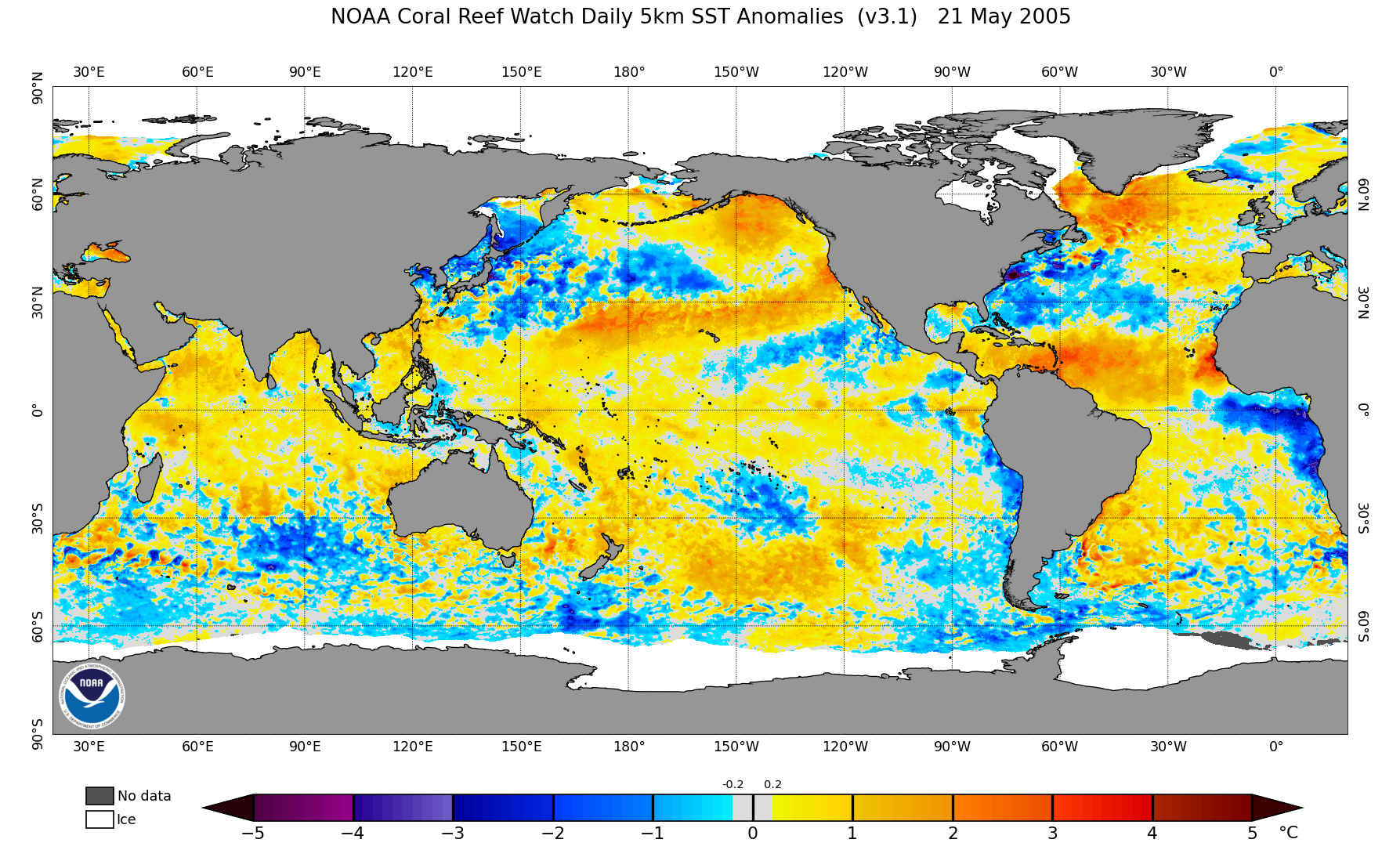
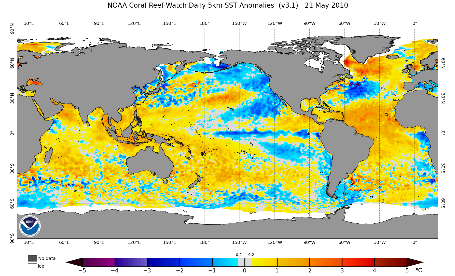
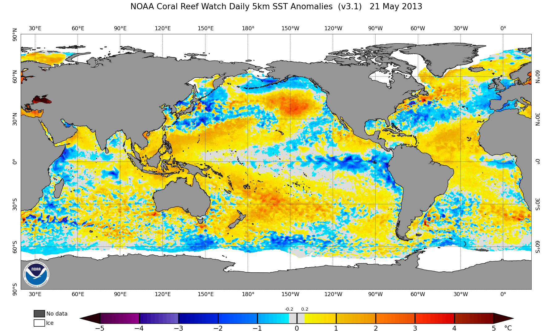
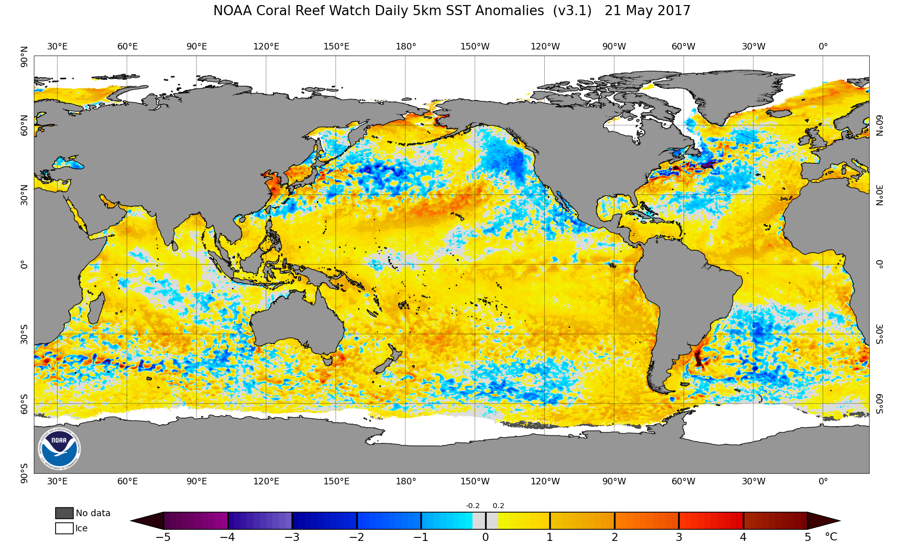
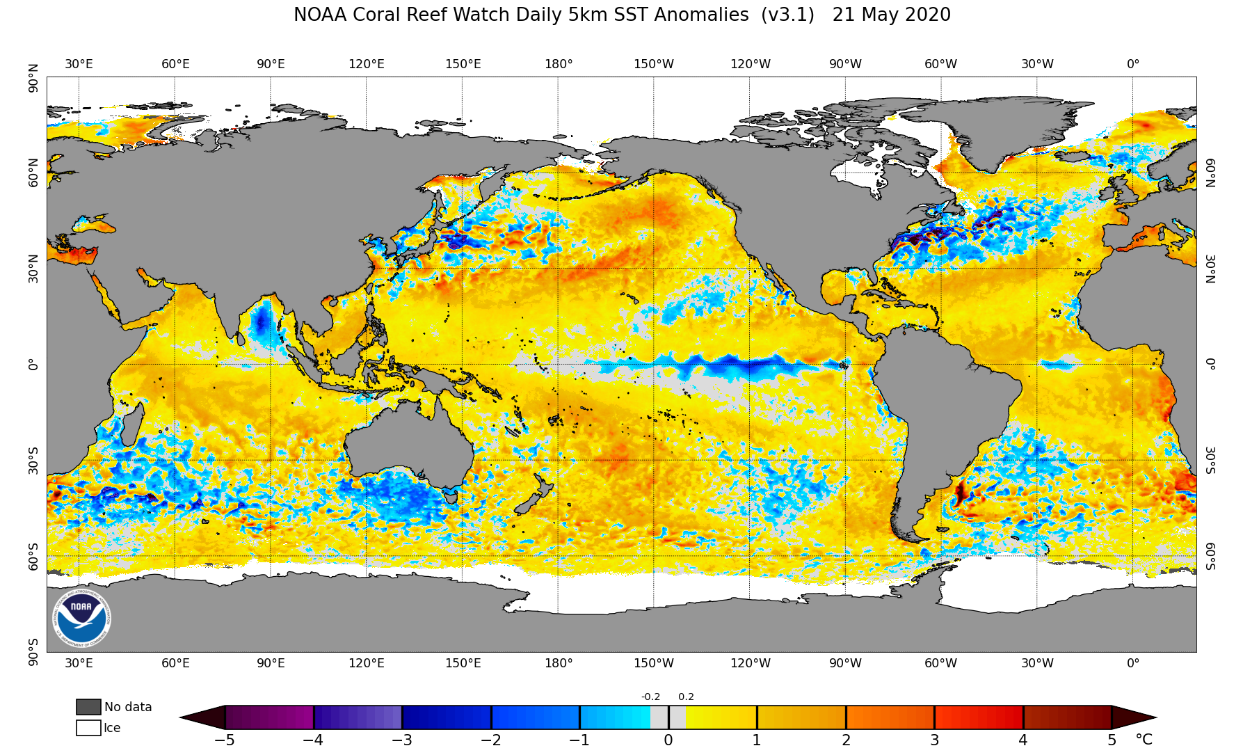
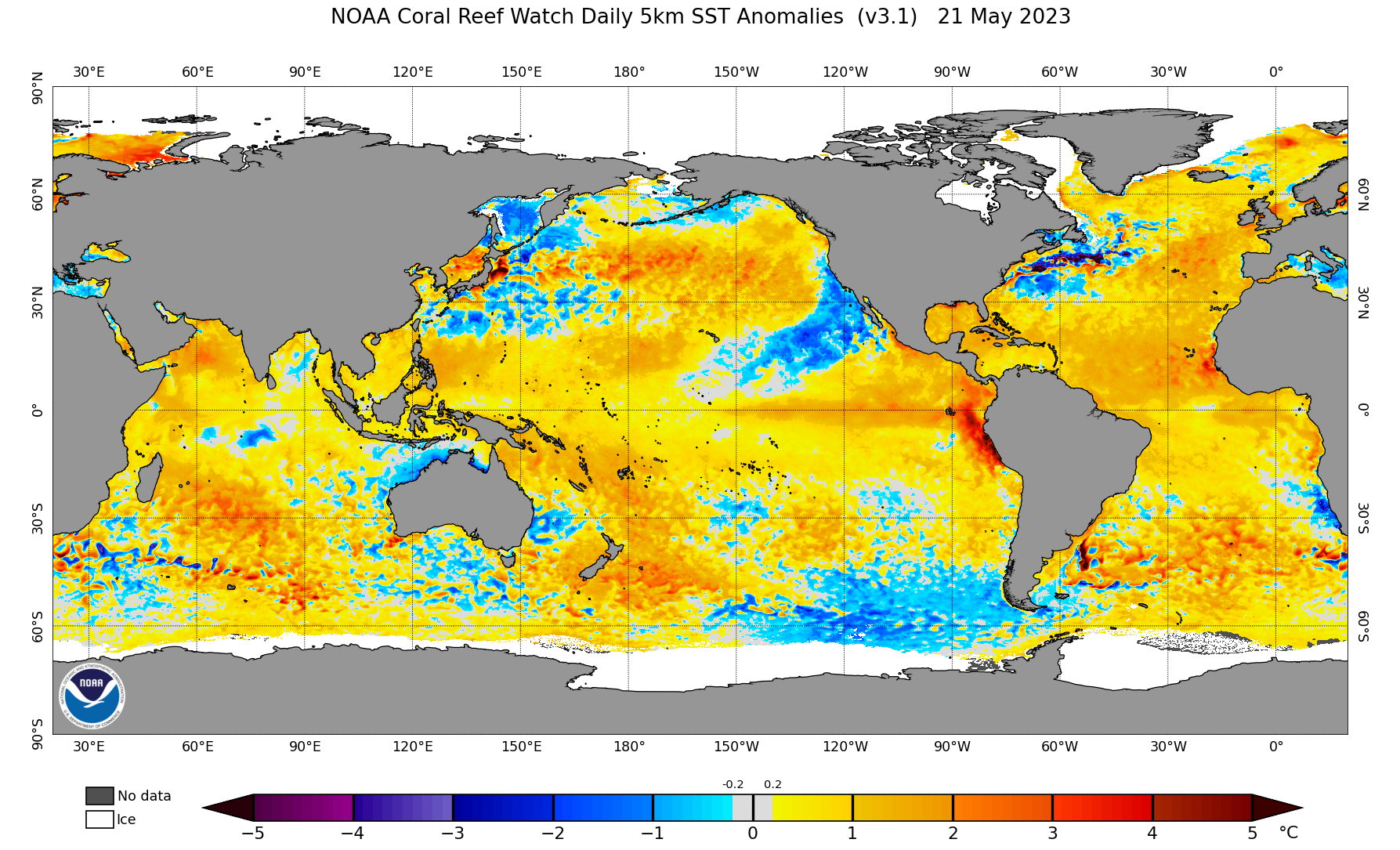
Just so we're clear:

2005:
Image

2010:
Image

2013:
Image

2017:
Image

2020:
Image

2023:
Image

And now, 2024:
Image
0 likes   
Unless explicitly stated, all information covered in my posts is based on my opinions and observations. Please refer to a professional meteorologist or an accredited weather research agency otherwise, especially if serious decisions must be made in the event of a potentially life-threatening tropical storm or hurricane.


Stratton23
Category 2
Category 2
Posts: 595
Joined: Fri Jul 21, 2023 10:59 pm
Location: College Station, Tx

Re: 2024 Indicators: SST's, MSLP, Shear, SAL, Steering, Instability (Day 16+ Climate Models)

#1033 Postby Stratton23 » Wed May 22, 2024 3:03 pm

The atlantic, GOM and the Caribbean right now are like someone leaving the bath water faucet on hot, but forgetting to turn it off, I swear every day its warming up even faster, seeing more 30 degree isotherm readings showing up in the southern gulf, I honestly could see multiple major hurricanes getting into the gulf this season
1 likes   

User avatar
cycloneye
Admin
Admin
Posts: 139479
Age: 67
Joined: Thu Oct 10, 2002 10:54 am
Location: San Juan, Puerto Rico

Re: 2024 Indicators: SST's, MSLP, Shear, SAL, Steering, Instability (Day 16+ Climate Models)

#1034 Postby cycloneye » Thu May 23, 2024 7:41 am

0 likes   
Visit the Caribbean-Central America Weather Thread where you can find at first post web cams,radars
and observations from Caribbean basin members Click Here

User avatar
NDG
S2K Supporter
S2K Supporter
Posts: 14934
Joined: Sun Jul 09, 2006 10:14 pm
Location: Orlando, FL

Re: 2024 Indicators: SST's, MSLP, Shear, SAL, Steering, Instability (Day 16+ Climate Models)

#1035 Postby NDG » Thu May 23, 2024 8:07 am

Crazy how below average shear is over the eastern Caribbean despite the MJO not being in our part of the world.
I have never seen the eastern Caribbean SSTs so warm this time of the year in the 28-30C range, when is usually in the 26-28C range at the most, not even this time in 2017. Definitely signs that this will be a hot spot.
Image
Image
0 likes   


User avatar
cycloneye
Admin
Admin
Posts: 139479
Age: 67
Joined: Thu Oct 10, 2002 10:54 am
Location: San Juan, Puerto Rico

Re: 2024 Indicators: SST's, MSLP, Shear, SAL, Steering, Instability (Day 16+ Climate Models)

#1037 Postby cycloneye » Thu May 23, 2024 10:09 am

1 likes   
Visit the Caribbean-Central America Weather Thread where you can find at first post web cams,radars
and observations from Caribbean basin members Click Here

User avatar
cycloneye
Admin
Admin
Posts: 139479
Age: 67
Joined: Thu Oct 10, 2002 10:54 am
Location: San Juan, Puerto Rico

Re: 2024 Indicators: SST's, MSLP, Shear, SAL, Steering, Instability (Day 16+ Climate Models)

#1038 Postby cycloneye » Thu May 23, 2024 12:33 pm

3 likes   
Visit the Caribbean-Central America Weather Thread where you can find at first post web cams,radars
and observations from Caribbean basin members Click Here

User avatar
Teban54
Category 5
Category 5
Posts: 1979
Joined: Sat May 19, 2018 1:19 pm

Re: 2024 Indicators: SST's, MSLP, Shear, SAL, Steering, Instability (Day 16+ Climate Models)

#1039 Postby Teban54 » Thu May 23, 2024 6:47 pm

0 likes   

User avatar
cycloneye
Admin
Admin
Posts: 139479
Age: 67
Joined: Thu Oct 10, 2002 10:54 am
Location: San Juan, Puerto Rico

Re: 2024 Indicators: SST's, MSLP, Shear, SAL, Steering, Instability (Day 16+ Climate Models)

#1040 Postby cycloneye » Thu May 23, 2024 7:08 pm

2014 beats 2010 on the warm sst's.

 https://x.com/philklotzbach/status/1793785444817404152


0 likes   
Visit the Caribbean-Central America Weather Thread where you can find at first post web cams,radars
and observations from Caribbean basin members Click Here


Return to “Talkin' Tropics”

Who is online

Users browsing this forum: Google Adsense [Bot], kevin, SteveM, tolakram and 27 guests