2024 Global Model Runs Discussion (Out thru day 16)
Moderator: S2k Moderators
Forum rules

The posts in this forum are NOT official forecasts and should not be used as such. They are just the opinion of the poster and may or may not be backed by sound meteorological data. They are NOT endorsed by any professional institution or STORM2K. For official information, please refer to products from the National Hurricane Center and National Weather Service.
-
AnnularCane

- S2K Supporter

- Posts: 2646
- Joined: Thu Jun 08, 2006 9:18 am
- Location: Wytheville, VA
Re: 2024 Global Model Runs Discussion (Out thru day 16)
I sort of feel like someday one of these "phantom" GFS storms will turn out to be the real thing.
0 likes
"But it never rained rain. It never snowed snow. And it never blew just wind. It rained things like soup and juice. It snowed mashed potatoes and green peas. And sometimes the wind blew in storms of hamburgers." -- Judi Barrett, Cloudy with a Chance of Meatballs
-
jlauderdal
- S2K Supporter
- Posts: 6776
- Joined: Wed May 19, 2004 5:46 am
- Location: NE Fort Lauderdale
- Contact:
Re: RE: Re: 2024 Global Model Runs Discussion (Out thru day 16)
The pattern is looking favorable in early june.skyline385 wrote:ChrisH-UK wrote:skyline385 wrote:GFS GFS'ing
Jokes aside, still a sign that we are slowly getting into favorable conditions as models start showing hints of future development.
[url]https://i.ibb.co/7zwyk1z/gfs-mslp-pcpn-atl-64.png [/url]
Looks like GFS is shifted it into the pacific, still way way off.
[url]https://imagizer.imageshack.com/v2/640x480q70/923/Y8QIuQ.png [/url]
Yea that's just how max range GFS will be and why it's notoriously unreliable. As I mentioned earlier, systems beginning to pop up on long range is more of a sign that conditions are becoming favorable and not that something is guaranteed to form, especially when it's the GFS at max range in the Caribbean.
0 likes
-
cycloneye

- Admin

- Posts: 139291
- Age: 67
- Joined: Thu Oct 10, 2002 10:54 am
- Location: San Juan, Puerto Rico
Re: 2024 Global Model Runs Discussion (Out thru day 16)
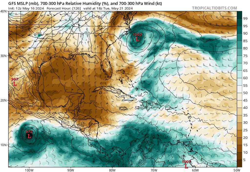
And now there are three. The Euro is left to join the others. Let's hope if this becomes a real thing, does not go to Acapulco.

1 likes
Visit the Caribbean-Central America Weather Thread where you can find at first post web cams,radars
and observations from Caribbean basin members Click Here
and observations from Caribbean basin members Click Here
-
skyline385

- Category 5

- Posts: 2498
- Age: 33
- Joined: Wed Aug 26, 2020 11:15 pm
- Location: Houston TX
Re: RE: Re: 2024 Global Model Runs Discussion (Out thru day 16)
jlauderdal wrote:The pattern is looking favorable in early june.skyline385 wrote:ChrisH-UK wrote:
Looks like GFS is shifted it into the pacific, still way way off.
[url]https://imagizer.imageshack.com/v2/640x480q70/923/Y8QIuQ.png [/url]
Yea that's just how max range GFS will be and why it's notoriously unreliable. As I mentioned earlier, systems beginning to pop up on long range is more of a sign that conditions are becoming favorable and not that something is guaranteed to form, especially when it's the GFS at max range in the Caribbean.
Indeed, EPS still shows the MJO moving in early June
0 likes
-
jlauderdal
- S2K Supporter
- Posts: 6776
- Joined: Wed May 19, 2004 5:46 am
- Location: NE Fort Lauderdale
- Contact:
Re: RE: Re: RE: Re: 2024 Global Model Runs Discussion (Out thru day 16)
Si Senorskyline385 wrote:jlauderdal wrote:The pattern is looking favorable in early june.skyline385 wrote:
Yea that's just how max range GFS will be and why it's notoriously unreliable. As I mentioned earlier, systems beginning to pop up on long range is more of a sign that conditions are becoming favorable and not that something is guaranteed to form, especially when it's the GFS at max range in the Caribbean.
Indeed, EPS still shows the MJO moving in early June
Start the genny everyone, if it needs service, this is the time. The seasonal forecasts must be taken seriousely, big numbers even if they underachieve. Also, donate what you can, it all adds up.
j
0 likes
-
weeniepatrol

- Category 3

- Posts: 865
- Joined: Sat Aug 22, 2020 5:30 pm
- Location: WA State
Re: 2024 Global Model Runs Discussion (Out thru day 16)
skyline385 wrote:GFS GFS'ing
Jokes aside, still a sign that we are slowly getting into favorable conditions as models start showing hints of future development.
[url]https://i.ibb.co/7zwyk1z/gfs-mslp-pcpn-atl-64.png [/url]
Phantom season has begun, folks. Welcome to 2024
1 likes
-
crownweather

- S2K Supporter
- Posts: 578
- Age: 49
- Joined: Sat Aug 12, 2006 9:21 am
- Location: Sturbridge, Massachusetts
- Contact:
Re: 2024 Global Model Runs Discussion (Out thru day 16)

Phantom season continues on the GFS model with a system in the Bahamas Memorial Day weekend.
Sent from my iPhone using Tapatalk
0 likes
Rob Lightbown
Crown Weather Services
https://crownweather.com
Crown Weather Services
https://crownweather.com
-
AnnularCane
- S2K Supporter
- Posts: 2646
- Joined: Thu Jun 08, 2006 9:18 am
- Location: Wytheville, VA
Re: 2024 Global Model Runs Discussion (Out thru day 16)
crownweather wrote:https://uploads.tapatalk-cdn.com/20240511/1380dad0a896a048ff3f71696ec53bcf.jpg
Phantom season continues on the GFS model with a system in the Bahamas Memorial Day weekend.
Sent from my iPhone using Tapatalk
And a swirly thing in the EPAC.
1 likes
"But it never rained rain. It never snowed snow. And it never blew just wind. It rained things like soup and juice. It snowed mashed potatoes and green peas. And sometimes the wind blew in storms of hamburgers." -- Judi Barrett, Cloudy with a Chance of Meatballs
-
Stratton23
- Category 2

- Posts: 574
- Joined: Fri Jul 21, 2023 10:59 pm
- Location: College Station, Tx
Re: 2024 Global Model Runs Discussion (Out thru day 16)
Favorable MJO phase moving in first week of june, while it could be another phantom system from the GFS, I do believe it is at least seeing the potential for a spin up in the W. Caribbean at the end of the month, it just blows my mind how warm the caribbean is right now
0 likes
-
skyline385
- Category 5
- Posts: 2498
- Age: 33
- Joined: Wed Aug 26, 2020 11:15 pm
- Location: Houston TX
Re: 2024 Global Model Runs Discussion (Out thru day 16)
Stratton23 wrote:Favorable MJO phase moving in first week of june, while it could be another phantom system from the GFS, I do believe it is at least seeing the potential for a spin up in the W. Caribbean at the end of the month, it just blows my mind how warm the caribbean is right now
IMO its not the case of a typical GFS phantom as we usually see. EPS and GEFS both show the MJO moving in and extended EPS has a 10-30% chance for a TD in the Caribbean around that time period. Now it could be the GFS Caribbean bias which develops it too much or too quickly but the potential is there.
1 likes

Re: 2024 Global Model Runs Discussion (Out thru day 16)
AnnularCane wrote:I sort of feel like someday one of these "phantom" GFS storms will turn out to be the real thing.
If one develops, the timeline generally will be pushed back and pushed back.
Of course I don't pay attention to these GFS phantom storms until another model sees something.
0 likes
-
skyline385
- Category 5
- Posts: 2498
- Age: 33
- Joined: Wed Aug 26, 2020 11:15 pm
- Location: Houston TX
Re: 2024 Global Model Runs Discussion (Out thru day 16)
Hmm GFS showing what looks like our first TW in less than a week. It would be right around climo in mid-May.

0 likes
-
skyline385
- Category 5
- Posts: 2498
- Age: 33
- Joined: Wed Aug 26, 2020 11:15 pm
- Location: Houston TX
Re: 2024 Global Model Runs Discussion (Out thru day 16)
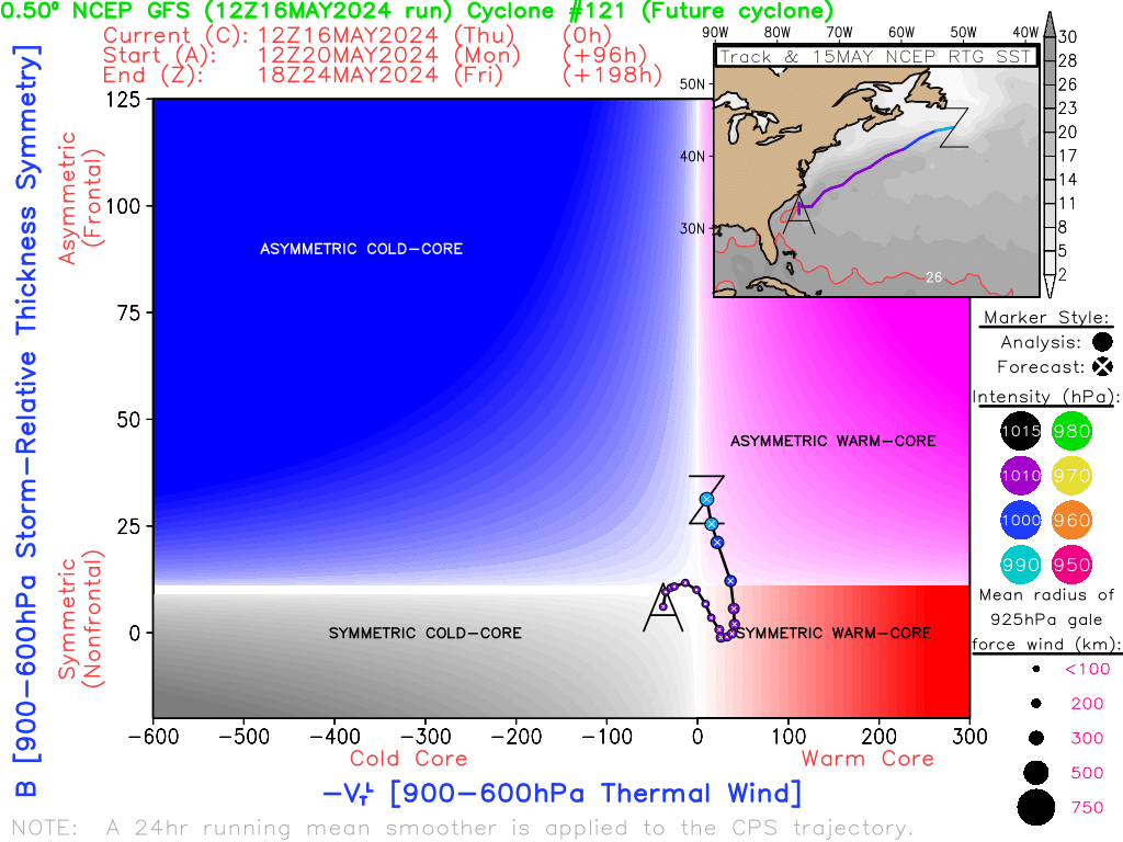
Phase diagrams also suggesting a warm core and this is where random spins up tend to happen this time in the season. Temps are slightly lower than usual there because of the cold pool but the loop current could still do its thing. Also on the other models as well.
1 likes


Re: 2024 Global Model Runs Discussion (Out thru day 16)
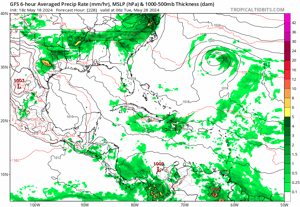
GFS is now showing a tropical wave moving North in the eastern Caribbean developing into a tropical depression/storm within 120 hours. This might be our first system of the season.
1 likes

Re: 2024 Global Model Runs Discussion (Out thru day 16)
tiger_deF wrote:GFS is now showing a tropical wave moving North in the eastern Caribbean developing into a tropical depression/storm within 120 hours. This might be our first system of the season.
Could happen, especially in this new era of flash tropical cyclone designations we've seen questionable short-lived spin-ups tagged on the merits of a few recon measurements. Looking at the GFS 850 mb vorticity forecast maps, the GFS has had a few recent model runs showing a clear cyclonic spin just north of Panama, right where the ITCZ seems to bulge up from the EPAC and over northern S. American. That coupled by a sharp trough dropping southward and a LARGE upper high building over the Eastern Caribbean, the disturbance mid-level vorticity itself would appear to drift or organize as it lifts northeastward while getting nudged under the building anticyclonic flow however remaining in a shear zone. I could better see a slim chance at short term development by this feature just south of Hispaniola and Puerto Rico and flooding potential that could pose a risk. I think that a Northeast moving disturbance just north of the Islands might see slightly better upper air conditions but only up to about 25N latitude where there would be a significant SST drop-off. Maybe there will be some increasing model support, but I think it's likely ceiling would be a short-lived 1-2 day TD (based on current day official nomenclature) but atm, I don't think this disturbance will quite merit what I would define as a T.D.
0 likes
Personal Forecast Disclaimer:
The posts in this forum are NOT official forecast and should not be used as such. They are just the opinion of the poster and may or may not be backed by sound meteorological data. They are NOT endorsed by any professional institution or storm2k.org. For official information, please refer to the NHC and NWS products.
The posts in this forum are NOT official forecast and should not be used as such. They are just the opinion of the poster and may or may not be backed by sound meteorological data. They are NOT endorsed by any professional institution or storm2k.org. For official information, please refer to the NHC and NWS products.
-
Hurricane2022

- Category 4

- Posts: 942
- Joined: Tue Aug 23, 2022 11:38 pm
- Location: Araçatuba, Brazil
Re: 2024 Global Model Runs Discussion (Out thru day 16)
Everybody loves GFS. 


0 likes
Sorry for the bad English sometimes...!
For reliable and detailed information for any meteorological phenomenon, please consult the National Hurricane Center, Joint Typhoon Warning Center , or your local Meteo Center.
--------
Una cvm Christo, pro Christo, et in Christo. Sit nomen Domini benedictvm.
For reliable and detailed information for any meteorological phenomenon, please consult the National Hurricane Center, Joint Typhoon Warning Center , or your local Meteo Center.
--------
Una cvm Christo, pro Christo, et in Christo. Sit nomen Domini benedictvm.
-
Category5Kaiju

- Category 5
- Posts: 3397
- Age: 22
- Joined: Thu Dec 24, 2020 12:45 pm
- Location: Seattle
Re: 2024 Global Model Runs Discussion (Out thru day 16)
Of course it’s probably just another phantom storm. I’m sure we’re no stranger to that.
But….hey, if there was ever a year that features that kind of system, it’s probably going to be this year lol
3 likes
Unless explicitly stated, all information covered in my posts is based on my opinions and observations. Please refer to a professional meteorologist or an accredited weather research agency otherwise, especially if serious decisions must be made in the event of a potentially life-threatening tropical storm or hurricane.
-
NotSparta

- Professional-Met

- Posts: 1655
- Age: 22
- Joined: Fri Aug 18, 2017 8:24 am
- Location: Naples, FL
- Contact:
Re: 2024 Global Model Runs Discussion (Out thru day 16)
Phantom time? Welcome to the 2024 hurricane season, folks
1 likes
This post was probably an opinion of mine, and in no way is official. Please refer to http://www.hurricanes.gov for official tropical analysis and advisories.
My website, with lots of tropical wx graphics, including satellite and recon: http://cyclonicwx.com
My website, with lots of tropical wx graphics, including satellite and recon: http://cyclonicwx.com
-
Blown Away

- S2K Supporter
- Posts: 9867
- Joined: Wed May 26, 2004 6:17 am
Re: 2024 Global Model Runs Discussion (Out thru day 16)
AnnularCane wrote:I sort of feel like someday one of these "phantom" GFS storms will turn out to be the real thing.
Welcome to the start of the 2024 Atlantic Hurricane Season… The GFS is on point with a May long range Central American Gyre solid phantom Cat 2 hovering around in the Caribbean!!!
3 likes
Hurricane Eye Experience: David 79, Irene 99, Frances 04, Jeanne 04, Wilma 05... EYE COMING MY WAY IN 2024…
Hurricane Brush Experience: Andrew 92, Erin 95, Floyd 99, Matthew 16, Irma 17, Ian 22, Nicole 22…
Hurricane Brush Experience: Andrew 92, Erin 95, Floyd 99, Matthew 16, Irma 17, Ian 22, Nicole 22…
-
skyline385
- Category 5
- Posts: 2498
- Age: 33
- Joined: Wed Aug 26, 2020 11:15 pm
- Location: Houston TX
Re: 2024 Global Model Runs Discussion (Out thru day 16)
First phantom of the season, the 2024 season begins now. The GFS trying to recreate Ian with that outflow lol
1 likes
Who is online
Users browsing this forum: Emmett_Brown, Google Adsense [Bot], jhpigott, ouragans, TheWisestofAll and 31 guests